Kawishiwi River Triangle
by sralig
Trip Type:
Paddling Canoe
Entry Date:
08/27/2020
Entry & Exit Point:
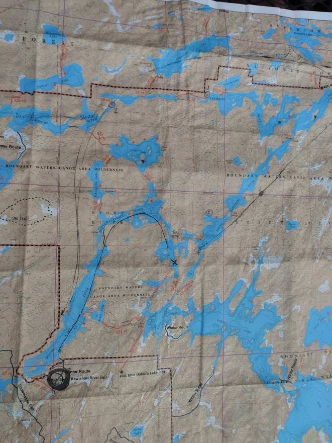
South Kawishiwi River (EP 32)
Number of Days:
4
Group Size:
2
Trip Introduction:
We selected this route for the river (avoid windy lakes), rocky shorelines (enjoy clear water), and portages around rapids. It was a huge success. For the second year in a row, we are lucky to have perfect weather and a dreamy trip in the wilderness.
Discuss Trip:
View Discussion Thread (10 messages)
Day 1 of 4
Wednesday, August 26, 2020
Kristin and I leave Saint Paul at noon to drive up to Ely. We stop at Betty’s Pies and are pleased to find it not too crowded, although COVID safety precautions are still in place so we order to-go and sit at a picnic table outside. We’re lucky to have gorgeous weather, blue sky, and a great view of the big lake. The vegetarian “backpacker” burger is a hit and we follow it up with our fruit servings for the day: slices of Blackberry Peach, Strawberry Rhubarb, and Raspberry Rhubarb pie to share.
We get to Ely around 6 pm and check in at the Paddle Inn. I find the pink tiled bathroom pretty darn charming and the motel style set up makes social distancing a breeze.
There’s still plenty of daylight left, so we wander out to find the “pillow rocks.” It’s a nice walk through town neighborhoods and the rock formation is cool, if a bit mystifying as a tourist attraction. We keep walking into town and pick up some drinks and treats to enjoy on our motel ‘porch.’
Thursday, August 27
When my alarm goes off at 6 AM I am instantly wide awake and eager to get going. Kristin and I drink a pitiful pot of free motel coffee, finish leftover pie, and head over to Piragis Outfitters to pick up map, canoe, and assorted gear. We make a quick stop at Northern Grounds for good coffee, bagels and a first study of our new map. We also enjoy speculating about the purpose and contents of “Loony’s Northwoods Emporium: Home of the Unusual” next door.
 By 8 AM, we turn onto the gravel road (“Spruce”) and approach Entry Point #32 South Kawishiwi River. I text my sister that I’m “turning off comms” and turn on airplane mode to save my phone battery for lots and lots of pictures.
Our plan is to complete the Kawishiwi River Triangle route in four days. A girl at the outfitter assures us she did it all in one day, but she is clearly much tougher and cooler than us. The first night, we hope to camp near the northeast corner. Kristin circles several potential campsites in the area.
 The entry portage is a long one, by our standards at least: 147 rods, or about ½ a mile. I am determined to make up for my laziness last year, when Kristin carried the canoe all but twice, so I claim the first portage and we agree to alternate thereafter. I am pleasantly surprised to find that it is not as miserable as I remembered; I would even call the first 100 or so rods enjoyable! Kristin is a good portage entertainer; over the course of the next four days I will learn a lot about Greek gods, astrology, sharks (good), and bears (bad). We finally round the last bend, take in the first of many stunning, sparkling vistas of the trip, and load the canoe around 10 AM.
We head north up the river about three miles, nearly to the point where the river will curve to the east. The next portage is a sweet little baby one that doesn’t even have a rod number listed on the map. We consider trying to float the rapids without getting out of the water, but decide it’s not worth a risk so early in the journey. It’s an easy two-person haul up and over a small hill, no bench-pressing-balancing-acts needed. It’s now noon and we perch on the rocks near the rapids for a hearty snack break. There is a campsite right here that I think would be nice for people who want an easy trip, without venturing as deep as we prefer. The sound of the babbling rapids would be pleasant and when we return this way, we’ll spot an otter and three noisy ducks. As we load up to continue our journey, another canoe approaches from the north and we meet the Honeymooners, a well-dressed couple in their 40s on their tenth anniversary in the boundary waters. They alert us to an ideal campsite they call the “taj mahal” around the riverbend, at the next set of rapids.
When considering route options way back in February, I selected this river route in an effort to avoid the perils we faced last year on Little Indian Sioux’s big windy lakes. The sun comes out and the wind picks up a little bit on this wider stretch of river, but the paddling is not bad at all.
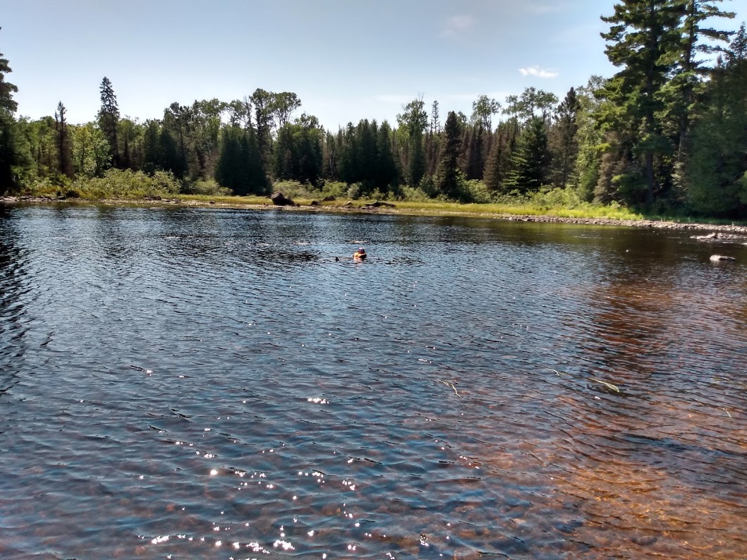
 About two miles later, we come to the first spot marked “rapids” on the map. This may be my favorite location in our four day journey. This is what the Honeymooners called the “taj mahal.” Although the map doesn’t indicate a portage here, we don’t see a clear path through by sea. The water parts around an island at the end of a pinch point. To the west, there is a narrow, fast-moving current with big boulders poking up. To the east, there is a wide, shallow channel with a rocky bottom. After attempting to traverse the westward passage, we reverse course, fearing a sharp collision with the big rocks. Instead, we choose the wide, shallow passage. We pull up at the mouth of it and Kristin climbs out into knee-deep, clear water and pulls the canoe with her hands to where I can also get out. This lightens the boat enough that we can manually float it over the rocks, walking slowly alongside. I don’t know why this is so much fun, but I feel like a kid at the best playground in the world. There’s a couple with a yellow dog on a distant shore watching us; we wave and the dog barks joyfully.
At this point, we could continue south on the river to a section the map has thrillingly stamped “DANGEROUS WATERS,” or turn left up the east leg of the Kawishiwi River Triangle. Much though I’m tempted by curiosity to at least peek at the “DANGEROUS WATERS,” we will stick to the plan and explore safer territory.
Kristin takes the next portage, a little 30 rod one that carries us past yet another small rapids. Who knew rapids are so fun? Every one so far has been stunningly beautiful. This is the emotional equivalent to a beautiful mountain vista at the end of a hard hike, but we get them all the time here! This portage is short but steep; one steep climb up and one steep climb down. We agree this is ideal - it feels like an accomplishment, but not a slog. On the other side, we find a wide, shallow bay with a rocky bottom. We decide to stick around for lunch and a swim in the sun-warmed, unbelievably clear water of the bay. The rocks are slick and the water doesn’t quite get deep enough for it to be my favorite swim, but dunking my head underwater makes the trip feel more real.
 Soon after, we reach the next short portage just on the other end of this wide part in the river. This one was so easy I hardly remember it, although I remember thinking we should have picked this one for our swim, with its deeper water and sandy beach. This portage marks the end of the route we’ll see twice; although we didn’t know it then, we would end up revisiting everything up to this point again two days later, in our hunt for an unoccupied campsite.
There’s a long paddle and one more rapids/portage in our path before we reach the northeast corner of the triangle where we plan to camp that night. I’m starting to lose track of where we’re at, but I enjoy paddling and looking around and getting lost in my thoughts. Kristin has the map and the navigation under control. She has been silent for a while. I start paying attention again as we pass one, then another, and another campsite, their current occupants clearly staking claim with bright tents and tendrils of smoke from campfires. We seem to be circling a long string of large, swampy islands. The sun is hanging low, hot and bright in the sky and it’s starting to seem like time to find solid land and set up camp.
When I ask Kristin for a navigation update, it’s clear she’s a little worried we’re running out of options. We start discussing backup plans if we find the next few campsites ahead are also taken. Should we land wherever possible if we get really desperate? Should we try to buddy up with an occupied campsite before then? I joke that we should let down anchor and sleep in the canoe. Kristin is not amused.
At this point, we are paddling west on the top leg of the triangle - well past where we expected to stop on the first day. We have a few hours of sunlight left so things are not too desperate, but we’re reaching a point where we will either have a long stretch ahead of us with no campsites and no guarantees, or we have a long trek back to the last unoccupied spot. As we round an island and see our last two options do in fact have campers already, our hearts drop and our hungry bellies grumble. The water is very still and the river is calm under a cloudless dusk. Kristin pulls out the map to consult with me, although her navigation skills are excellent and I trust her word on the situation. A solitary fisherman a short distance away notices our predicament, and calls over. His words carry easily across the quiet water. He asks us if we’re looking for a campsite. He tells us that he just came from the west and he thinks there are a few options over there, about a 30 minute paddle away in the direction we’re already heading - there are three campsites and he only saw one couple. We shout our thanks for the good news, and hustle onward.
Although I’m hopeful that we’ll find his words are true, I watch the shoreline for any worst-case-scenario places to at least pull up the canoe and string up a hammock for the night. It’s against the BWCA rules, but we can’t stay on the water ‘til morning. In any event, there are no good options along here - the terrain juts up steep and high above the water (averaging a height about ~1,500 feet, according to the map) where it’s not boggy swamp.
When at last we reach a bay with the final three red-dotted campsites on the map, we find the older couple the fisherman had mentioned. They are at the first campsite, which is immediately next to a 20 rod portage to a second campsite on Conchu Lake. It seems likely that if there is any free camp left on this river, it’s the one that is on the other side of a dead-end portage. (Who wants to haul 40 pounds of kevlar on their head just for a campsite??) We pull up and ask the couple if they know if it is available. They think so, but they’re not positive as they have themselves just arrived. We pull in the canoe and Kristin runs up the trail to scout ahead while I wait with the canoe and eavesdrop on the older couple. Their elderly golden retriever gently picks his way down to the shoreline and looks at me calmly with age-filmed eyes. Kristin soon reemerges but doesn’t have a clearer answer. She says the trail seemed really overgrown and she didn’t see a campsite at the end of it - it’s possible it’s only accessible by canoe on the other side. We decide to risk leaving this one in order to check out the very last option a short distance away. The couple jokes that they will scare off anyone who comes for it, in case we need to come back.
As Kristin navigates us to the next red dot, I paddle hard in the back of the boat, my heart pounding in fearful anticipation of glimpsing brightly colored polyester or the hull of a beached canoe. I squint warily at a large white figure on the shore ahead until it resolves into a sun-bleached tree trunk. Happily, every second we get closer to the shore the more clear it becomes that this site is free. We have found a safe, rule-abiding home for the night!
I’m shocked there is still daylight at this point, but we have a few hours left in which to set up camp. This seems like a good spot, with a short climb up big, terraced stones covered in lichen and moss. It’s a little challenging to find a spot clear of dead fir trees, however, and at one point Kristin calls over “Sarah? This tree is making weird noises.” I laugh and continue unpacking until she says in a wavering voice, “Sarah - come listen to this tree.” As I approach curiously, I start to hear it too - there is a continuous, chewing drone coming from the tree and it is surrounded by piles of sawdust. I feel a full body-shudder and back away. Termites? Some type of wood-boring beetle? Something has killed all the fir trees at this campsite and their tall skeletons are gray and drab. Now that I know what I’m hearing, that chewing sound surrounds us.
Kristin finally finds a pair of living trees from which to hang her hammock, some distance away from camp and above a precipitous drop over water. Likewise, our hunt for a bear-bag tree leads us down a steep hill and across a small ditch. Not the easiest campsite, but we’re glad for a place to plant ourselves after a long first day.
Kristin and I leave Saint Paul at noon to drive up to Ely. We stop at Betty’s Pies and are pleased to find it not too crowded, although COVID safety precautions are still in place so we order to-go and sit at a picnic table outside. We’re lucky to have gorgeous weather, blue sky, and a great view of the big lake. The vegetarian “backpacker” burger is a hit and we follow it up with our fruit servings for the day: slices of Blackberry Peach, Strawberry Rhubarb, and Raspberry Rhubarb pie to share.
We get to Ely around 6 pm and check in at the Paddle Inn. I find the pink tiled bathroom pretty darn charming and the motel style set up makes social distancing a breeze.
There’s still plenty of daylight left, so we wander out to find the “pillow rocks.” It’s a nice walk through town neighborhoods and the rock formation is cool, if a bit mystifying as a tourist attraction. We keep walking into town and pick up some drinks and treats to enjoy on our motel ‘porch.’
Thursday, August 27
When my alarm goes off at 6 AM I am instantly wide awake and eager to get going. Kristin and I drink a pitiful pot of free motel coffee, finish leftover pie, and head over to Piragis Outfitters to pick up map, canoe, and assorted gear. We make a quick stop at Northern Grounds for good coffee, bagels and a first study of our new map. We also enjoy speculating about the purpose and contents of “Loony’s Northwoods Emporium: Home of the Unusual” next door.
Our plan is to complete the Kawishiwi River Triangle route in four days. A girl at the outfitter assures us she did it all in one day, but she is clearly much tougher and cooler than us. The first night, we hope to camp near the northeast corner. Kristin circles several potential campsites in the area.
We head north up the river about three miles, nearly to the point where the river will curve to the east. The next portage is a sweet little baby one that doesn’t even have a rod number listed on the map. We consider trying to float the rapids without getting out of the water, but decide it’s not worth a risk so early in the journey. It’s an easy two-person haul up and over a small hill, no bench-pressing-balancing-acts needed. It’s now noon and we perch on the rocks near the rapids for a hearty snack break. There is a campsite right here that I think would be nice for people who want an easy trip, without venturing as deep as we prefer. The sound of the babbling rapids would be pleasant and when we return this way, we’ll spot an otter and three noisy ducks. As we load up to continue our journey, another canoe approaches from the north and we meet the Honeymooners, a well-dressed couple in their 40s on their tenth anniversary in the boundary waters. They alert us to an ideal campsite they call the “taj mahal” around the riverbend, at the next set of rapids.
When considering route options way back in February, I selected this river route in an effort to avoid the perils we faced last year on Little Indian Sioux’s big windy lakes. The sun comes out and the wind picks up a little bit on this wider stretch of river, but the paddling is not bad at all.
At this point, we could continue south on the river to a section the map has thrillingly stamped “DANGEROUS WATERS,” or turn left up the east leg of the Kawishiwi River Triangle. Much though I’m tempted by curiosity to at least peek at the “DANGEROUS WATERS,” we will stick to the plan and explore safer territory.
Kristin takes the next portage, a little 30 rod one that carries us past yet another small rapids. Who knew rapids are so fun? Every one so far has been stunningly beautiful. This is the emotional equivalent to a beautiful mountain vista at the end of a hard hike, but we get them all the time here! This portage is short but steep; one steep climb up and one steep climb down. We agree this is ideal - it feels like an accomplishment, but not a slog. On the other side, we find a wide, shallow bay with a rocky bottom. We decide to stick around for lunch and a swim in the sun-warmed, unbelievably clear water of the bay. The rocks are slick and the water doesn’t quite get deep enough for it to be my favorite swim, but dunking my head underwater makes the trip feel more real.
There’s a long paddle and one more rapids/portage in our path before we reach the northeast corner of the triangle where we plan to camp that night. I’m starting to lose track of where we’re at, but I enjoy paddling and looking around and getting lost in my thoughts. Kristin has the map and the navigation under control. She has been silent for a while. I start paying attention again as we pass one, then another, and another campsite, their current occupants clearly staking claim with bright tents and tendrils of smoke from campfires. We seem to be circling a long string of large, swampy islands. The sun is hanging low, hot and bright in the sky and it’s starting to seem like time to find solid land and set up camp.
When I ask Kristin for a navigation update, it’s clear she’s a little worried we’re running out of options. We start discussing backup plans if we find the next few campsites ahead are also taken. Should we land wherever possible if we get really desperate? Should we try to buddy up with an occupied campsite before then? I joke that we should let down anchor and sleep in the canoe. Kristin is not amused.
At this point, we are paddling west on the top leg of the triangle - well past where we expected to stop on the first day. We have a few hours of sunlight left so things are not too desperate, but we’re reaching a point where we will either have a long stretch ahead of us with no campsites and no guarantees, or we have a long trek back to the last unoccupied spot. As we round an island and see our last two options do in fact have campers already, our hearts drop and our hungry bellies grumble. The water is very still and the river is calm under a cloudless dusk. Kristin pulls out the map to consult with me, although her navigation skills are excellent and I trust her word on the situation. A solitary fisherman a short distance away notices our predicament, and calls over. His words carry easily across the quiet water. He asks us if we’re looking for a campsite. He tells us that he just came from the west and he thinks there are a few options over there, about a 30 minute paddle away in the direction we’re already heading - there are three campsites and he only saw one couple. We shout our thanks for the good news, and hustle onward.
Although I’m hopeful that we’ll find his words are true, I watch the shoreline for any worst-case-scenario places to at least pull up the canoe and string up a hammock for the night. It’s against the BWCA rules, but we can’t stay on the water ‘til morning. In any event, there are no good options along here - the terrain juts up steep and high above the water (averaging a height about ~1,500 feet, according to the map) where it’s not boggy swamp.
When at last we reach a bay with the final three red-dotted campsites on the map, we find the older couple the fisherman had mentioned. They are at the first campsite, which is immediately next to a 20 rod portage to a second campsite on Conchu Lake. It seems likely that if there is any free camp left on this river, it’s the one that is on the other side of a dead-end portage. (Who wants to haul 40 pounds of kevlar on their head just for a campsite??) We pull up and ask the couple if they know if it is available. They think so, but they’re not positive as they have themselves just arrived. We pull in the canoe and Kristin runs up the trail to scout ahead while I wait with the canoe and eavesdrop on the older couple. Their elderly golden retriever gently picks his way down to the shoreline and looks at me calmly with age-filmed eyes. Kristin soon reemerges but doesn’t have a clearer answer. She says the trail seemed really overgrown and she didn’t see a campsite at the end of it - it’s possible it’s only accessible by canoe on the other side. We decide to risk leaving this one in order to check out the very last option a short distance away. The couple jokes that they will scare off anyone who comes for it, in case we need to come back.
As Kristin navigates us to the next red dot, I paddle hard in the back of the boat, my heart pounding in fearful anticipation of glimpsing brightly colored polyester or the hull of a beached canoe. I squint warily at a large white figure on the shore ahead until it resolves into a sun-bleached tree trunk. Happily, every second we get closer to the shore the more clear it becomes that this site is free. We have found a safe, rule-abiding home for the night!
I’m shocked there is still daylight at this point, but we have a few hours left in which to set up camp. This seems like a good spot, with a short climb up big, terraced stones covered in lichen and moss. It’s a little challenging to find a spot clear of dead fir trees, however, and at one point Kristin calls over “Sarah? This tree is making weird noises.” I laugh and continue unpacking until she says in a wavering voice, “Sarah - come listen to this tree.” As I approach curiously, I start to hear it too - there is a continuous, chewing drone coming from the tree and it is surrounded by piles of sawdust. I feel a full body-shudder and back away. Termites? Some type of wood-boring beetle? Something has killed all the fir trees at this campsite and their tall skeletons are gray and drab. Now that I know what I’m hearing, that chewing sound surrounds us.
Kristin finally finds a pair of living trees from which to hang her hammock, some distance away from camp and above a precipitous drop over water. Likewise, our hunt for a bear-bag tree leads us down a steep hill and across a small ditch. Not the easiest campsite, but we’re glad for a place to plant ourselves after a long first day.
 Donate - BWCA.com