Kawishiwi River Triangle
by sralig
Trip Type:
Paddling Canoe
Entry Date:
08/27/2020
Entry & Exit Point:
South Kawishiwi River (EP 32)
Number of Days:
4
Group Size:
2
Discuss Trip:
View Discussion Thread (10 messages)
Day 3 of 4
Saturday, August 29
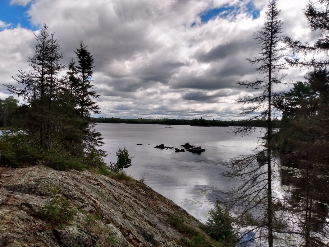 This time it’s our turn to look for the portage to Clear Lake, which fortunately gives us no trouble. I’m lucky to travel with such a good navigator! It’s my turn to carry the canoe and it’s another long one: 160 rods. The view at the end is well worth it. I think this is the best one yet! We’re in a wide bay, decorated with lots of big boulder-islands that make me think of Ariel’s iconic perch in The Little Mermaid. There’s a small cliff to the right that we scramble up for an even better look at the gorgeous scenery. This lake is big but shallow and filled with islands. Like rapids, islands are just fun!
We paddle across Clear Lake, hugging the southern shore. We could turn directly south here and portage into Eskwagama Lake, but by crossing the lake now we’ll save ourselves a long portage in the end. The lake is windier than the river has been, and it’s hard to hold the canoe steady while we wait for two young men to unload ahead of us. They chivalrously linger to help us unload, but we’re old hat at this by now and proud of our own competence.
 This (100 rod) portage is a little different from the others so far. The ground is boggy, with hummocks of flattened grass that ooze muddy water with every step. We find ourselves surrounded by shrubby vegetation, tall grasses, and thorny raspberry bushes. Halfway in, the path enters dense pine forest with low branches that scrape across the hull of the canoe, a particularly nasty torture for anyone with their head stuck inside it. Lucky for me, that’s Kristin.
We encounter the young men again at the end of this portage and ask them where they plan to camp. It’s still early morning, but we hope to avoid a repeat of the first night by staking an early claim. After this portage, we will come full circle with the bottom of the Kawishiwi River Triangle, so we’re in a good position to make our exit on Sunday. The man with the handlebar mustache pulls his map from a pocket in his lifejacket and shows us where he has circled several campsites upriver.
We are a couple of miles north of the ‘taj mahal’ and it’s not circled on his map, so Kristin and I aim for that one. We’re heading in the same direction as the men and it feels companionable to know it’s our new friends in the boat across the distance. In fact, when we reach the ‘taj mahal’ rapids, we find the men have pulled close to shore and are looking ahead uncertainly, not sure how to pass through. Kristin and I explain our solution from the first day, when we walked the canoe over the shallow channel, but they choose to brave the other side.
Unfortunately, a large group of teens and one small white fluffy dog are setting up camp at the ‘taj mahal’ campsite. As Kristin and I stand ankle deep on the rocks of the shallow channel, we see one girl up above us taking a selfie. Kristin calls up to ask her where they came from, and if they knew of any available campsites but the instagram girl brushes her off.
At this point, our casual search for a campsite turns into an awkward competition with the mustachioed men from the boggy portage. There are two campsites left in this area of the river and the four of us battle the wind to race east and claim a spot. Of course, the first one we pass is occupied by a large orange tent and several hammocks snapping in the wind. We exchange good-natured jibes with the men and Kristin and I gleefully paddle our hardest.
In the end, we are defeated by our own worst ‘Minnesota Nice’ demons, as we round the bend almost simultaneously, with our canoe a hairsbreadth closest to the final campsite, and the men shout to ask us if we want to take it. As if it’s theirs to offer! We offer to race them to it and they say we can have it. Some insanity compels us to decline, but they continue to shout condolence offers like “last chance! Are you sure?” as we paddle away in search of the next option.
Of course, it’s still early in the day and half the fun of paddling is doing so with a purpose and a mission. The mustaches can spend their afternoon fishing. Boring! We’re on the hunt!
Our next option requires a re-trek of the 30 rod up-down hilly portage where we stopped to swim on Day 1. This takes us back to a section of the river where heading south would take us to the “DANGEROUS WATERS.” The map shows a campsite fairly nearby but in the southward direction.
Kristin is focused intensely on the map, watching for this southern campsite and wary of loud rapids to our left, when we feel a bump and hear the dreaded scraaaaaaaape of rock-on-kevlar. The canoe stops moving and no amount of paddling helps dislodge us. We are beached on a huge, sharp rock just inches under the surface of the water.
Kristin sticks her leg over the side and gets her foot on the top of the rock, trying to push us off. The canoe tips alarmingly to the other side. I ask if she can put her weight on the rock, which might be enough to free us, but it’s too sharp for that and a risky maneuver anyway. I suggest that she lean back in the canoe to try to distribute her weight back to the middle, while I paddle - this seems to help a little, but not enough to free us. Again, she reaches out with one foot to try pushing and this time it does the trick. We’re free! But also feeling a little spooked and chastened for our overconfidence.
We round the cove slowly in search of the southern campsite. We hug the shore and scrutinize every break in the trees for a fire grate, trail, or other obvious landmark. As we near the rapids, it seems clear that there isn’t a campsite on this side of them. Perhaps we’re meant to go through them? I haven’t seen the map in a while. In the stern, I try to hold us steady while Kristin takes a closer look at it. With frustration and no little anxiety in her voice, she tells me there is no portage marked here, and suggests that maybe the dot is slightly askew on the map. Maybe the rapids are supposed to be obviously passable and we're just being weenies. It’s very windy and it feels like the current is sucking us in. It’s clear that Kristin’s confidence is faltering after our run-in with the devil rock a few minutes earlier, so I try to stay upbeat and suggest we check out the other side.
We let the wind and water pull us into this sharp-rocked channel, but feeling like we have little control over the boat and high risk, we lose confidence halfway through and Kristin kicks out her leg one more time to steady us against a boulder while I ping-pong our stern between two others with the handle of my paddle. While we’re half-stabilized here, Kristin asks me to take a look at the map and provide a second opinion.
I love looking at the map at the end of the day, but I’m next to useless at orienteering. This time is no exception. I can tell Kristin needs me to be a better teammate, so I kneel down and stretch forward carefully while she hands it back to me. It takes a long moment for my eyes to find where we are now and I read it backwards on the first attempt, thinking we are on the west side of the 30 rod portage instead of the east. When I finally figure it out, I share Kristin’s frustration. There should be a campsite Right. Here. On this side of the rapids!
Kristin wants to search the shore again, but I don’t see how we could have missed it. I argue that we ought to move on. There are two more sites about a mile north of us and we’re burning daylight.
We still have to extricate ourselves from these rapids where we’re precariously stabilized, and now both wind and current are against us. As we push and paddle ferociously backwards, a sharp gust of wind tears my hat off my head and into the water, and threatens to pull my paddle out of my hands as well. Kristin catches the hat and shoves it under her seat. As we backtrack, we keep an eye on the shore, just in case we did miss a clearing in the trees above us before. Later that night, Kristin will remember that this red dot was marked with a big ‘X’ on the map the two men were using. We can only assume that means it has been decommissioned since our map was printed.
As we turn north, the wind eases up a small amount and we continue to hug the shoreline. There’s one big bulbous section of river to cross. It’s still early afternoon, but I hope these campsites are free so we don’t have a repeat of our first desperate night, or a long journey back out on Sunday.
Our luck starts to turn when Kristin spots movement in the water ahead, and we see three little otter faces poke up. The otters look at us for a long moment, vanish, and then continue splashing and playing a few yards farther ahead. We stop paddling just to watch them for many long minutes until they are finally out of sight.
When we reach the north end of this bulb in the river, we find both campsites are free. We select the one at the northern tip of a large, calm cove. After missing the ‘taj mahal,’ passing up the one for mustache boys, and simply not finding the last one, we discover that our luck has led us to the most dreamy possible campsite of all. This one has large clearings covered in soft reddish cedar needles from impossibly tall trees. The fire grate is in a clearing slightly above water level, and there are many intriguing trails leading to a variety of tent pads nearby. One trail leads up a series of small hills to a flat stone terrace high above the water. Here we decide to have a late lunch. We sit and gaze at nature’s beauty for a long time in silence. Over and over, the sun warms us almost to the point of discomfort, then ducks behind a cloud until we feel a chill and crave its warmth again. Kristin says she wouldn’t change a thing about it, except to wish for a comfy chair and a cold beer. Eventually, I pull out my book and Kristin and I take turns dozing and reading chapters out loud.
 When the sun-warmed lethargy wears off, it is late afternoon. We set up camp quickly, fight off a gang of shockingly brave and avaricious chipmunks, and haul the canoe back into the water for one more easy evening paddle. Although we must have seen this part of the river on Thursday, it all seems brand new to me. We poke along the shoreline, pausing often in the calm water just to watch and listen. As the sun inches lower, it becomes too painfully bright to look west, so we cling to the eastern shore and soak in the last rays. We pause for a long time listening to something just beyond our vision shaking the trees and tapping rocks or shells. An eagle rides the vents high above.
Eventually it becomes necessary to cross the river to the west, and I shiver as the shadow of the treeline falls over us and the temperature drops perceptibly. The sky turns lighter and the few clouds glow pink and orange. As dusk falls, we land our boat and we each rush off to find warm, dry clothes. Kristin gets a fire going while I filter water and we wait for our dinners to re-hydrate. The moon is almost too bright to see the stars but I can make out a few constellations. There is no shortage of dry cedar wood, and we take turns once again - one of us reading out loud by headlamp while the other pokes at the fire and watches moonlight ripple on the river.
Unlike the previous morning, I wake up several times on Saturday and decide to keep dozing. I feel luxurious and vaguely guilty. Eventually, sure that it must be almost noon (in reality it’s closer to 8 AM), I hear Kristin puttering around and the hiss of the camp stove. As we sit and drink our coffee, several fishermen pass by and wave up at us.
We paddle across Clear Lake, hugging the southern shore. We could turn directly south here and portage into Eskwagama Lake, but by crossing the lake now we’ll save ourselves a long portage in the end. The lake is windier than the river has been, and it’s hard to hold the canoe steady while we wait for two young men to unload ahead of us. They chivalrously linger to help us unload, but we’re old hat at this by now and proud of our own competence.
We encounter the young men again at the end of this portage and ask them where they plan to camp. It’s still early morning, but we hope to avoid a repeat of the first night by staking an early claim. After this portage, we will come full circle with the bottom of the Kawishiwi River Triangle, so we’re in a good position to make our exit on Sunday. The man with the handlebar mustache pulls his map from a pocket in his lifejacket and shows us where he has circled several campsites upriver.
We are a couple of miles north of the ‘taj mahal’ and it’s not circled on his map, so Kristin and I aim for that one. We’re heading in the same direction as the men and it feels companionable to know it’s our new friends in the boat across the distance. In fact, when we reach the ‘taj mahal’ rapids, we find the men have pulled close to shore and are looking ahead uncertainly, not sure how to pass through. Kristin and I explain our solution from the first day, when we walked the canoe over the shallow channel, but they choose to brave the other side.
Unfortunately, a large group of teens and one small white fluffy dog are setting up camp at the ‘taj mahal’ campsite. As Kristin and I stand ankle deep on the rocks of the shallow channel, we see one girl up above us taking a selfie. Kristin calls up to ask her where they came from, and if they knew of any available campsites but the instagram girl brushes her off.
At this point, our casual search for a campsite turns into an awkward competition with the mustachioed men from the boggy portage. There are two campsites left in this area of the river and the four of us battle the wind to race east and claim a spot. Of course, the first one we pass is occupied by a large orange tent and several hammocks snapping in the wind. We exchange good-natured jibes with the men and Kristin and I gleefully paddle our hardest.
In the end, we are defeated by our own worst ‘Minnesota Nice’ demons, as we round the bend almost simultaneously, with our canoe a hairsbreadth closest to the final campsite, and the men shout to ask us if we want to take it. As if it’s theirs to offer! We offer to race them to it and they say we can have it. Some insanity compels us to decline, but they continue to shout condolence offers like “last chance! Are you sure?” as we paddle away in search of the next option.
Of course, it’s still early in the day and half the fun of paddling is doing so with a purpose and a mission. The mustaches can spend their afternoon fishing. Boring! We’re on the hunt!
Our next option requires a re-trek of the 30 rod up-down hilly portage where we stopped to swim on Day 1. This takes us back to a section of the river where heading south would take us to the “DANGEROUS WATERS.” The map shows a campsite fairly nearby but in the southward direction.
Kristin is focused intensely on the map, watching for this southern campsite and wary of loud rapids to our left, when we feel a bump and hear the dreaded scraaaaaaaape of rock-on-kevlar. The canoe stops moving and no amount of paddling helps dislodge us. We are beached on a huge, sharp rock just inches under the surface of the water.
Kristin sticks her leg over the side and gets her foot on the top of the rock, trying to push us off. The canoe tips alarmingly to the other side. I ask if she can put her weight on the rock, which might be enough to free us, but it’s too sharp for that and a risky maneuver anyway. I suggest that she lean back in the canoe to try to distribute her weight back to the middle, while I paddle - this seems to help a little, but not enough to free us. Again, she reaches out with one foot to try pushing and this time it does the trick. We’re free! But also feeling a little spooked and chastened for our overconfidence.
We round the cove slowly in search of the southern campsite. We hug the shore and scrutinize every break in the trees for a fire grate, trail, or other obvious landmark. As we near the rapids, it seems clear that there isn’t a campsite on this side of them. Perhaps we’re meant to go through them? I haven’t seen the map in a while. In the stern, I try to hold us steady while Kristin takes a closer look at it. With frustration and no little anxiety in her voice, she tells me there is no portage marked here, and suggests that maybe the dot is slightly askew on the map. Maybe the rapids are supposed to be obviously passable and we're just being weenies. It’s very windy and it feels like the current is sucking us in. It’s clear that Kristin’s confidence is faltering after our run-in with the devil rock a few minutes earlier, so I try to stay upbeat and suggest we check out the other side.
We let the wind and water pull us into this sharp-rocked channel, but feeling like we have little control over the boat and high risk, we lose confidence halfway through and Kristin kicks out her leg one more time to steady us against a boulder while I ping-pong our stern between two others with the handle of my paddle. While we’re half-stabilized here, Kristin asks me to take a look at the map and provide a second opinion.
I love looking at the map at the end of the day, but I’m next to useless at orienteering. This time is no exception. I can tell Kristin needs me to be a better teammate, so I kneel down and stretch forward carefully while she hands it back to me. It takes a long moment for my eyes to find where we are now and I read it backwards on the first attempt, thinking we are on the west side of the 30 rod portage instead of the east. When I finally figure it out, I share Kristin’s frustration. There should be a campsite Right. Here. On this side of the rapids!
Kristin wants to search the shore again, but I don’t see how we could have missed it. I argue that we ought to move on. There are two more sites about a mile north of us and we’re burning daylight.
We still have to extricate ourselves from these rapids where we’re precariously stabilized, and now both wind and current are against us. As we push and paddle ferociously backwards, a sharp gust of wind tears my hat off my head and into the water, and threatens to pull my paddle out of my hands as well. Kristin catches the hat and shoves it under her seat. As we backtrack, we keep an eye on the shore, just in case we did miss a clearing in the trees above us before. Later that night, Kristin will remember that this red dot was marked with a big ‘X’ on the map the two men were using. We can only assume that means it has been decommissioned since our map was printed.
As we turn north, the wind eases up a small amount and we continue to hug the shoreline. There’s one big bulbous section of river to cross. It’s still early afternoon, but I hope these campsites are free so we don’t have a repeat of our first desperate night, or a long journey back out on Sunday.
Our luck starts to turn when Kristin spots movement in the water ahead, and we see three little otter faces poke up. The otters look at us for a long moment, vanish, and then continue splashing and playing a few yards farther ahead. We stop paddling just to watch them for many long minutes until they are finally out of sight.
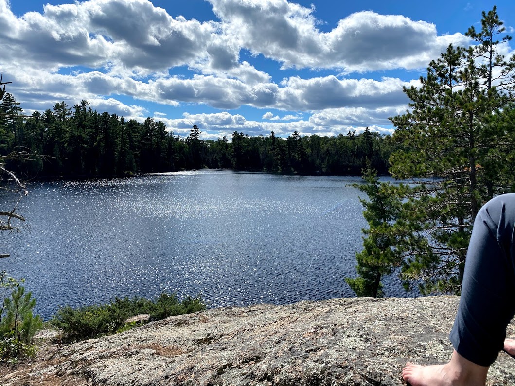
When we reach the north end of this bulb in the river, we find both campsites are free. We select the one at the northern tip of a large, calm cove. After missing the ‘taj mahal,’ passing up the one for mustache boys, and simply not finding the last one, we discover that our luck has led us to the most dreamy possible campsite of all. This one has large clearings covered in soft reddish cedar needles from impossibly tall trees. The fire grate is in a clearing slightly above water level, and there are many intriguing trails leading to a variety of tent pads nearby. One trail leads up a series of small hills to a flat stone terrace high above the water. Here we decide to have a late lunch. We sit and gaze at nature’s beauty for a long time in silence. Over and over, the sun warms us almost to the point of discomfort, then ducks behind a cloud until we feel a chill and crave its warmth again. Kristin says she wouldn’t change a thing about it, except to wish for a comfy chair and a cold beer. Eventually, I pull out my book and Kristin and I take turns dozing and reading chapters out loud.
Eventually it becomes necessary to cross the river to the west, and I shiver as the shadow of the treeline falls over us and the temperature drops perceptibly. The sky turns lighter and the few clouds glow pink and orange. As dusk falls, we land our boat and we each rush off to find warm, dry clothes. Kristin gets a fire going while I filter water and we wait for our dinners to re-hydrate. The moon is almost too bright to see the stars but I can make out a few constellations. There is no shortage of dry cedar wood, and we take turns once again - one of us reading out loud by headlamp while the other pokes at the fire and watches moonlight ripple on the river.
 Donate - BWCA.com