BWCA Entry Point, Route, and Trip Report Blog
July 14 2025
Entry Point 32 - South Kawishiwi River
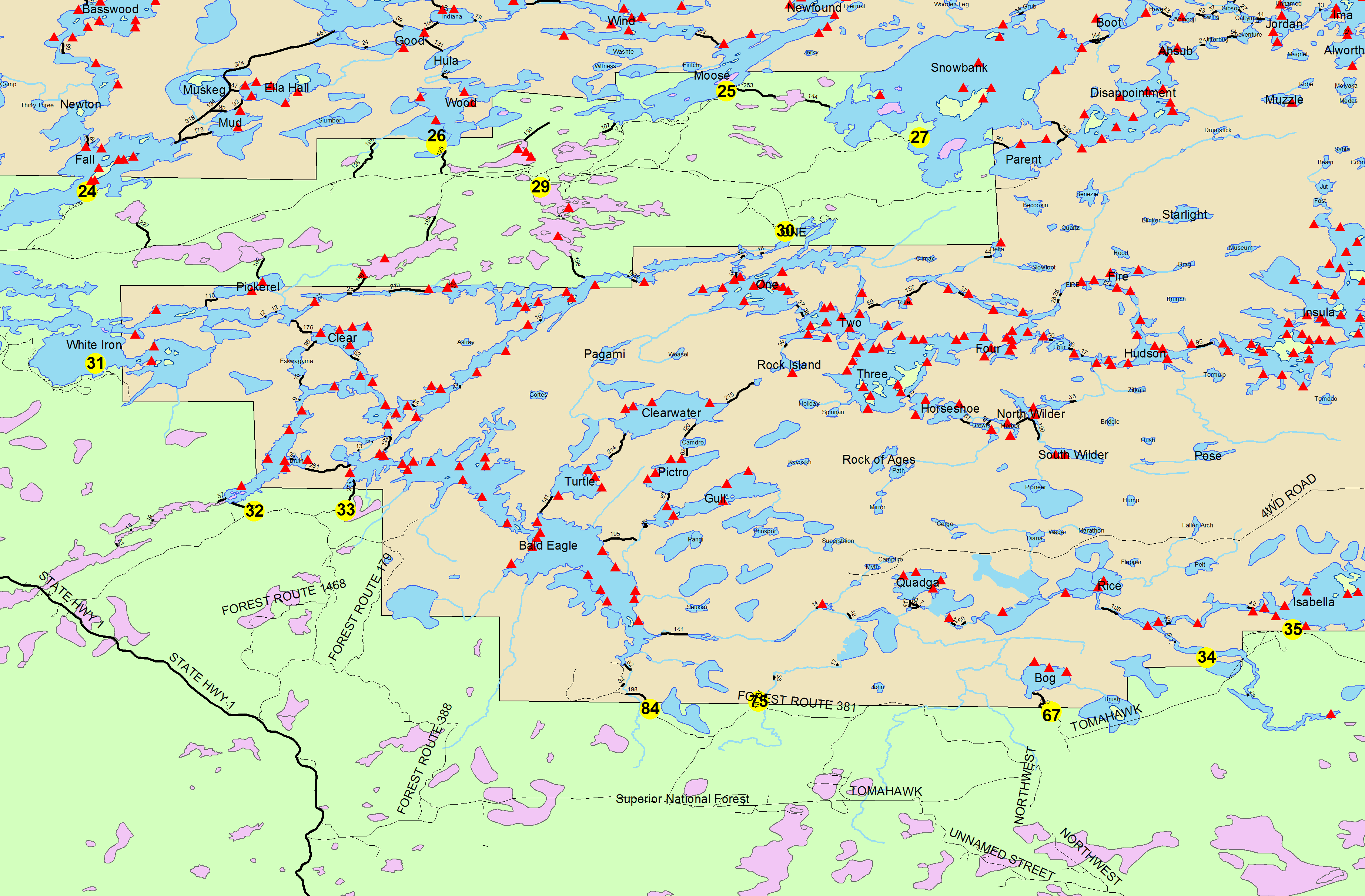
South Kawishiwi River entry point allows overnight paddle only. This entry point is supported by Kawishiwi Ranger Station near the city of Ely, MN. The distance from ranger station to entry point is 21 miles. Access is a 140-rod portage to the river.
Number of Permits per Day: 2
Elevation: 1201 feet
Latitude: 47.8419
Longitude: -91.6632
South Kawishiwi River - 32
Number of Permits per Day: 2
Elevation: 1201 feet
Latitude: 47.8419
Longitude: -91.6632
South Kawishiwi River - 32
August 2004 - South Kawishiwi/Clearwater Loop
by canoerone
Trip Report
Entry Date:
August 02, 2004
Entry Point:
South Kawishiwi River
Exit Point:
Little Gabbro Lake (33)
Number of Days:
7
Group Size:
5
Trip Introduction:
Our group consisted of four men and one teenage boy. Two were experienced trippers and three were rookies. Our seven day trip was planned to enter the Boundary Waters Canoe Area (BWCA) at Entry 32, proceed up the South Kawishiwi River, enter Little Gabbro Lake from the north, paddle through Gabbro Lake, Bald Eagle Lake, Turtle Lake, Clearwater Lake, Camdre Lake, Pietro Lake, Gull Lake and back through Bald Eagle, the Gabbros and exit the BWCA through Entry 33.
We left Fort Worth, TX at 6:00 am July 31 and drove to Ames, IA for the night. The next day we drove on to Babbitt, MN, secured a motel room for the night and then checked in with our outfitter (Duane’s Outfitting). Jim Hanson, at Duane’s, was quite adept in getting us in and out with all of our necessary gear and questions answered.
Report
DAY ONE: On August 2 we arrived back at Duane’s Outfitting about 6:30 am and, after a quick cup of coffee and a sweet roll, were soon on our way to the entry point. Jim dropped us off about 7:30 am at Entry 32 (South Kawishiwi River). The carry to the river amounts to 140 rods of mostly rolling terrain with lots of rocks and roots. The last 20 rods is downhill and over a boardwalk to the river. Put-in is tight and restricts loading to one canoe at a time.
The paddle up the beautiful South Kawishiwi River was an enjoyable way to get our “sea legs” under us and to get used to our canoe mate. About 2-3/4 miles up the river we had a quick five rod portage around a small rapid. The portage path on the left bank was flat and wide, allowing us a partial unload and four-carry the balance of equipment in the canoes.
We paddled on another 2-1/4 miles or so to the 125 rod portage to Little Gabbro Lake. With the water levels low, this portage and most of the portages encountered on our trip had very shallow water landing and leaving. The portage to Little Gabbro seemed longer than the stated 125 rods. It is a reasonably good path climbing the first 50 rods then a steeper section of about 10 rods. It then flattens out until the last 10 rods where it descends steeply to the lake. The lake side was shallow and sandy so we got wet feet, but not muddy.
Little Gabbro Lake is a relatively shallow lake about 150 acres in size that supports four campsites. The channel to the east provides access to the much larger Gabbro Lake.
Gabbro Lake is about 2-1/2 miles long (about 900 acres) with most of its depth over 15 feet. Gabbro supports nine campsites. The east end of Gabbro has a channel that connects to Bald Eagle Lake. Traveling east usually requires a short portage around a small rapid. Traveling west out of Bald Eagle this rapid is often run by experienced paddlers.
We had planned to camp half way down Gabbro Lake on the first day, but all campsites were taken well before lunch. This forced us to continue on to Bald Eagle Lake. We did the short portage around the drain for Bald Eagle, walked the canoes through very shallow water just passed the drain and continued down the lake looking for an empty campsite.
Bald Eagle Lake is a pretty lake that stretches east from Gabbro for about 3-1/2 miles (about 1200 acres). It has a 36’ max. depth and hosts 13 campsites. Caution when crossing Bald Eagle, its waves can be quite impressive.
We were almost to the point of giving up on finding a campsite on Bald Eagle and heading back to the long portage to Turtle Lake when we found a little used campsite hidden behind an island. It was not a choice campsite. The low water and rocks made getting close to shore a problem. This made unloading and loading a chore, but under the circumstances we were tickled to find a place to stop. It had been a much longer first-day paddle than what we had planned.
DAY TWO: We awoke early, had a quick breakfast and broke camp. Since we were so far down Bald Eagle from our planned portage to Turtle Lake and very close to the return portage from Gull Lake, we decided to reverse our planned loop and headed for the Gull Lake portage.
We had a little trouble locating the portage and once found faced another shallow/muddy unload. The 190 rod portage climbs steeply for the first 50 rods then is rolling for the next 50 rods. A gradual descent drops steeply the last few rods as is gets to Gull Creek. This portage path was very rocky and required much care where you placed your feet. The creek-side exit was very small and would handle only one canoe at a time. Many rocks in front of the narrow exit made getting out into the creek with loaded canoes a real challenge.
The short paddle up Gull Creek was a pleasant change from the miles of into-the-wind lake travel we had been experiencing. We made our way up the creek to the portage to Gull Lake and again found very shallow water and lots of mud. The 40 rod portage from the creek to Gull Lake was steep for the first 10 rods, levels off and then drops into gull Lake.
Gull Lake is a larger lake about 2-1/4 miles long (about 500 acres) situated in the hills north of Bald Eagle. Maximum depth is 31 feet. It has five established campsites.
We located a pretty nice campsite on Gull and quickly had camp setup. We had planned a layover day on Gull and ended up glad we did. The fishing on Gull was much better than we had expected for an August trip. Quite a few pike and smallmouth bass were caught and released.
DAY THREE: Awoke to a north breeze with a little touch of Fall in it. The breeze made it a little difficult to fish from the canoes, but we still managed to boat and release enough to keep our interest high.
DAY FOUR: This was to be a travel day so we awoke early to find the lake engulfed in a pea soup thick fog. We broke camp and got on the lake about 7:00 am. Finding the portage on the other side of the lake in a dense fog was interesting, but did not present any undo problems.
The 60 rod portage from Gull to Pietro Lake is pretty much a lousy trail. It is basically flat, but even in dry weather was still very muddy.
Pietro Lake is a pretty lake with clear water. It is about 1-1/2 miles long (about 340 acres) with a maximum depth of 31 feet. It supports four campsites.
We continued on, paddling across Pietro into a north breeze. The portage out of Pietro to Camdre Lake is a ways down the bank from the location shown on the maps (both Fisher and McKensie) and a little hard to spot. The 65 rod portage is in pretty good shape, but seemed to be little used. It climbs steeply the first 20 rods and then levels off and gradually drops down to Camdre. The short paddle (1/4 mile) across Camdre was a little break between portages.
Camdre Lake is small and shallow. ¼ mile across (about 50 acres), it has no game fish and no campsites. Note: The McKensie map wrongly shows the portage to Clearwater in the northeast corner of the lake. The Fisher map shows it correctly in the northwest corner of the lake.
The 125 rod portage from Camdre to Clearwater Lake was very shallow on both ends. Unloading and loading was again a wet, muddy affair. The portage path is little used, narrow, rocky and muddy in spots. It rises over a small hill and then gradually drops to Clearwater.
Clearwater Lake is large (2 miles long and about 650 acres) and deep with remarkably clear water. It is a pretty lake with four campsites.
We found a nice campsite on Clearwater and proceeded to setup camp. The clear water and bright sunshine made it a real challenge for the fishermen. One average size largemouth bass was all that they caught in Clearwater. We won’t waste our time fishing the next time through that lake.
DAY FIVE: We left the camp on Clearwater about 7:30 am and again had to paddle into the wind to get to the Turtle Lake portage. The 200 rod portage climbs steadily for the first 60 rods then levels off pretty much for the next 80 rods. It then descends gradually into Turtle. The trail is not traveled much and is very rocky and muddy in spots. About 2/3 the way across there is a muddy section of about five rods that can’t be avoided. The Turtle side of the portage is very shallow with knee deep mud that slowed our progress.
Turtle Lake is a shallow lake (15’ max.) about 1-1/4 mile across (about 340 acres) with distinctly cloudy water. It has four campsites. The campsite on the northern island is very nice. The only game fish in Turtle are pike.
All of the campsites on Turtle were vacant so we opted for the island site. It sits well above the water level and provides a beautiful view of the lake. Fishing on Turtle was good. We didn’t catch huge numbers, but the pike we caught were large. The largest was 37” long and weighed 11 pounds. With the good fishing and great campsite, we decided to make Turtle another layover lake.
DAY SIX: We awoke this morning to a beautiful rainbow right out in front of our campsite. It was quite a thrill to awake to God’s handiwork like that. The breeze this day was cooler and a light rain started to fall at about 8:00 am. The rain stopped at lunch time, but the wind continued to blow. We spent much of the afternoon playing Spades in the tent. After supper the wind subsided enough to allow the fishermen one more opportunity to catch a few fish. Late evening was spent doing some preliminary packing for our trip out the next day.
DAY SEVEN: We left camp about 7:00 am with the weather cool and overcast. It seems that some days it doesn’t matter what direction you are paddling, the wind is always in your face. This was one of those days. We paddled across Turtle to the Bald Eagle portage to find another shallow/rocky entry. The 186 rod portage climbs steeply the first 30 rods then is slightly downhill for the next 120 rods. The last part drops sharply down into Bald Eagle Lake. The portage exit is very shallow and muddy.
Mist fell on our group as we paddled across Bald Eagle, while we did the short portage into Gabbro, across Gabbro and Little Gabbro. The mist stopped as we approached the portage out to Entry 33. The portage landing was a bit crowded so we took advantage of a nearby campsite to pause and have a bite of lunch. This gave the portage crowd time to pass through and since we were ahead of schedule, allowed us to kill some time.
The 200 rod carry from Little Gabbro to Entry 33 has a nice landing area (no wet muddy feet here!). The path climbs the first 20 rods and then is rolling the rest of the way. This is an excellent trail with only a few rocky spots. Probably the best trail we traveled all week. For its length, it is not a difficult portage.
Duane’s picked us up at Entry 33 about 2:15 pm. We hated to have it end so quickly, but a great time was had by all. Good weather, good fishing and good companions in the BWCA – it made for a great week.
discuss this trip report (6 comments) - last post on September 17, 2019