| Previous Messages: |
| OutdoorEnthusiast79 |
08/11/2020 04:53PM
Thanks for all the information, everyone. Much appreciated. From the sounds of it, I'm sure I'll find a nice site and have some good fishing.
|
| dentondoc |
08/10/2020 04:21PM
Argo: "
UTM is the only way I can do it. I don't know from where you're all getting these site numbers. "
Argo -
Sorry, I must have been replying when you made your correction.
The site numbers, at least for most people, are coming from a fairly popular canoeing site that has been around for a few years. For me, I was acquainted with the original developer since we were both associated with another canoe board. That board shared a lot of material among the members. The database containing all of the known campsites in Quetico was among the items shared, each with "number" designation (e.g., "AC" from my previous post). Board members, over the years, contributed information about these campsites, so this was a "community" effort.
So, when I am planning a canoe trip, I just hop on my personal computer, load mapping software that already has campsites, portages and a few other informational items listed. I create a subset for each trip and download that to my GPS and print a copy on waterproof paper for my trip maps.
dd
This is a sample map from a recent trip.

|
| Argo |
08/10/2020 12:13PM
dentondoc: "Jackfish: "Argo: "E 587854 N 5387986
In a protected bay with a good rock landing."
Pat, what do those numbers represent? Is the campsite you're referencing marked online or on a map?"
They appear to be UTM coordinates. However, when plotted, I get a point north of campsite AC (very near Cirrus) despite using a couple of different "base" adjustments. AC's position is 15 U 587775 5386934; base reference WGS 84.
dd"
Correct. Clumsy of me!
|
| dentondoc |
08/10/2020 11:41AM
Jackfish: "Argo: "E 587854 N 5387986
In a protected bay with a good rock landing."
Pat, what do those numbers represent? Is the campsite you're referencing marked online or on a map?"
They appear to be UTM coordinates. However, when plotted, I get a point north of campsite AC (very near Cirrus) despite using a couple of different "base" adjustments. AC's position is 15 U 587775 5386934; base reference WGS 84.
dd
|
| Argo |
08/10/2020 11:35AM
Jackfish: "Argo: "E 587854
N 5387986
In a protected bay with a good rock landing."
Pat, what do those numbers represent? Is the campsite you're referencing marked online or on a map?"
CORRECTION - that should read 5386986
They are UTM grid references found on many Canadian topo maps. They are simply metric readings used by applying a grid over the map in sq metric blocks. Northings represent distances from the equator. This site is 5,386,986 meters from the equator. Eastings are a little more complex and are based on a starting point associated with a particular map's longitudinal grid reference which in this case is 15U. There many sites that can convert waypoints from one system to another. Your GPS will do it too.
UTM is the only way I can do it. I don't know from where you're all getting these site numbers.
|
| Jackfish |
08/10/2020 11:12AM
Argo: "E 587854
N 5387986
In a protected bay with a good rock landing."
Pat, what do those numbers represent? Is the campsite you're referencing marked online or on a map?
|
| dentondoc |
08/10/2020 10:45AM
If the above reference is for campsite AC (north side; good rock landing), it is a very good campsite and I've stayed there (perhaps a decade ago). However, when I went by there in 2019, there was a huge log laying across the campsite and directly on top of the firepit. Unless it has been removed (would likely require a chain saw), I'd pass on this one.
I have stayed on the mid-lake island campsite (BJ). The east side landing is a slot in the rock face and can be a little tricky with an easterly wind. However, you can land on the west side when the rare easterly wind prevails. This is a large campsite with several tent pad and hammock hanging options. Most of the site lies to the north of the landing, but there area some nice viewing spots toward the south on the west side. The firepit is against a rock face and protected from westerly winds.
Campsite BC, on a smaller island south of BJ is serviceable for a small group. It has a so-so landing and a couple of fairly good tent pads. Its back in the trees a bit so, I'd think limited air movement. There is a mating pair of bald eagles that use this island as a nesting site. So, you would have at least auditory "entertainment" when the nest is occupied by fledglings.
You should be able to do the Grand Slam on this lake. I don't recall catching smallies on my last trip, but did catch the other three. If you decide the camp in the area of BC or BJ, I'd fish the area ("bay") south of there. You can usually turn up a few walleye there. While I did catch a laker east of the BJ's island last year, but I'd typically spend more time drift fishing the center of the lake west of BJ for trout. Then there is the submerged ridge line (5-20 feet deep) that begins at a tiny island (or rock outcrop) that is NE of BJ and generally runs on a line SSE. Depths on either side run 40-60 feet (or more).
dd
|
| Argo |
08/10/2020 08:16AM
E 587854
N 5387986
In a protected bay with a good rock landing.
|
| OutdoorEnthusiast79 |
08/10/2020 06:35AM
Thanks for the info, much appreciated. I am also contemplating the central part of the lake, and will also keep my eyes open for other sites. Just thought the west end might be best as it would likely be a little more sheltered from prevailing wind, and I will be heading out that way as well.
|
| billconner |
08/10/2020 05:33AM
Wish I could help. IIRC I stayed at 9X and my profile photo be was taken near there. BC was my goal, but taken. Wish I could find my trip report here but can't. There are sites not on the maps, so keep your eyes open.
|
| Jackfish |
08/09/2020 09:44PM
Paging BillConner to the white courtesy phone.
|
| OutdoorEnthusiast79 |
08/09/2020 06:58PM
Planning on heading to Kasakokwog Lake next weekend for a few nights. I wanted to see if anyone had any information on campsites on that lake. I was specifically interested in site 9G, on the small western most island. Any information on any of the other sites would also be appreciated. Thanks.
|
 Boundary Waters Quetico Forum
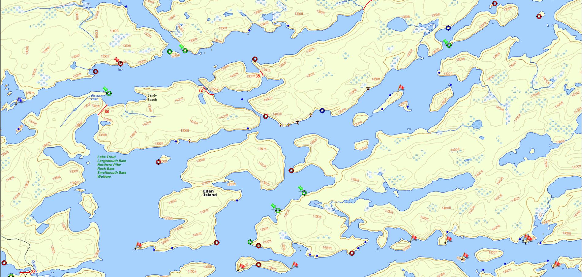
 Search BWCA.com
 Donate