|
||||
 Boundary Waters Quetico Forum Quetico Forum Stupid question - where exactly is the Nym Lake put-in? Reply Boundary Waters Quetico Forum Quetico Forum Stupid question - where exactly is the Nym Lake put-in? Reply
|
| Previous Messages: | |
| Author | Message Text |
| Eyedocron |
08/10/2022 07:23PM When I read the original question, I recalled having a picture of the Nym Lake sign at the floating dock. Hope you have, or have had, a great trip! |
| rick00001967 |
08/10/2022 05:32PMDancesWithTrees: "Hello again everyone. Haven't posted in a while, and haven't been to the Q in about 14 years. Haven't been to Nym in far longer. for what it's worth.....i was in and out of nym this past weekend. if i remember correctly i think from the Batchewaung portage to the dock is roughly about a 30 degree heading. i could see the green sign (someone posted a pic above) from really far away on a sunny day. i can def confirm the proper parking lot is the area circled on the right of the pic posted above. there is a floating rubber dock there. it is a short uphill walk to the lot from the dock. the lot has a cover sitting area and toilets as well. it is only a few minutes drive out to the highway. it sure is a busy place. there was about 30 vehicles in the lot when i got there on saturday. |
| rick00001967 |
08/05/2022 11:34AM great timing for this question. i was just looking for this exact information. thx all. |
| DancesWithTrees |
08/02/2022 08:42AM Thanks everyone - sounds like the eastern/northeastern one of the three is the "correct" one for Quetico, and where the Quetico parking lot is. Someone is dropping our car there *for* us so we won't know the roads/lots situation ahead of time. We just know the outfitter will drive away in our car from Beaverhouse, and park it at Nym Lake. If we were dropping our own car off there, we could just walk down from the lot to mark where the dock/entry/exit point is. |
| LarryS48 |
08/02/2022 08:10AMtumblehome: "It is not the middle one. It is the right circle. The two points are only a few hundred yards apart. The Green Quetico sign is visible from a long distance. IT is 4’ x4’. Agreed! The middle one is for locals going to Nym. The one on the right (further northeast) is for people with permits going into Quetico. I am not sure what would happen if you parked in the wrong lot. I doubt the park wants its lot filling up with boat trailers. I also suspect that the Atikokan civic organizations that provided the boat ramp don’t want their lot full of cars from canoe trippers. |
| tumblehome |
08/02/2022 06:37AM It is not the middle one. It is the right circle. The two points are only a few hundred yards apart. The Green Quetico sign is visible from a long distance. IT is 4’ x4’. There is a tall antenna on the peninsula so when you see the antenna you know you are heading to the right spot. As mentioned, there is an official Nym Lake Quetico parking lot and there is a well marked sign on the gravel road that points you to turn left to the parking lot. The Quetico parking lot is unmistakable with a small pavilion with historical and cultural panel boards under it. Tom |
| LarryS48 |
08/02/2022 03:37AM I believe the middle one is the access for locals to put boats in. The part of the road you see there going into the water is a boat ramp. The one on the East is the one with the floating dock. There is actually a short portage from the parking lot to the dock. From the water watch for the sign and paddle back into the bay. When driving your car in, I believe the sign said something like Quetico Paddlers access. Make sure you coordinate with the person who parks the car so you know which one the car is at. The first time I was there, I stopped at the boat ramp but saw no dock but there was a parking lot. Then a Quetico Portage crew paddled by and went into the bay heading to the dock. We followed and found the expected dock. |
| Old salt |
08/01/2022 10:02PM It’s the middle one on the peninsula. Look for the sign as pictured. Have fun! |
| DancesWithTrees |
08/01/2022 09:13PM
Thanks. Right. Nym Lake Road ends in various places on that peninsula. Which of the many fingers of the peninsula (and road) is where this floating dock is? I see Nym Lake Road with about 3 different end points with open areas, all at different parts of that peninsula, near the shoreline. Here is a screen shot of what I see, with various road end points in white, to illustrate. I circled three areas that look like maybe where the landing is, in yellow. Do you happen to know the specific point and/or road end (yellow circle area) is the put-in / take-out? 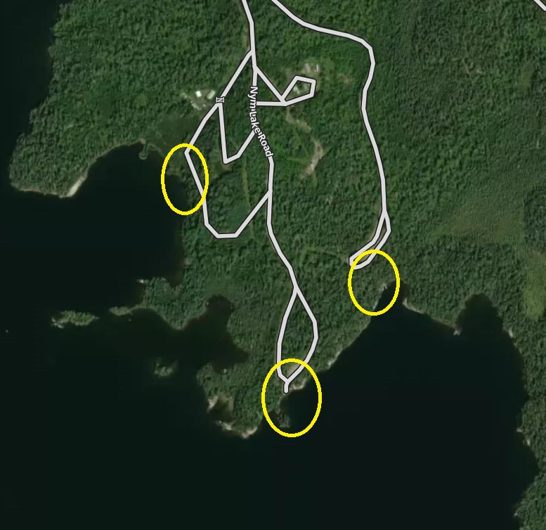
|
| Eyedocron |
08/01/2022 07:24PM Nym: From the road. Go a short distance east from the Atikokan turn off, The Nym Lake road is nicely marked and a short distance to the parking lot. Even has an outhouse. The short downhill portage to the lake is on the SE side of the lot and there is even a floating dock. From the south (presumably Batch...) go up the narrows in the NW corner of the lake. When Batch... opens up wider again, head NE to where the north shore on the left and a large peninsula on the right meet. There is your single portage to Nym. Don't take the double portage slightly west of there that goes through a swampy pond. At the Nym end, head NNE between islands and past an island canoeing camp with cabins. There is a wide inlet with the Nym Lake sign and the floating dock on the left. If you go to the east side of the wide peninsula, you went too far. 
|
| DancesWithTrees |
08/01/2022 06:39PM Hello again everyone. Haven't posted in a while, and haven't been to the Q in about 14 years. Haven't been to Nym in far longer. Where exactly is the put-in at Nym? We are doing a one-way from Beaverhouse to Nym, someone is leaving our car in the Nym lot for us. But the last time we took out at Nym I remember spending a long time trying to find the darn take-out. And since we won't see it ahead of time and need to find it from the water, it would be great if I could pinpoint it on a map before I leave. I've searched Google Maps and other online maps and layers, and cannot find a good answer. The "end of Nym Lake Road" isn't terribly helpful since the road has branches to a bunch of places kinda near the shoreline. Anyone have a map image or precise location of the take-out? I would greatly appreciate it! |
 Search BWCA.com
 Donate