|
 Boundary Waters Quetico ForumFishing ForumDry Lake Trail -- winter lake access?
|
 Forum Sponsor

Author
Text
")
09/20/2019 02:16PM
Hi folks. For those who have hiked the Dry Lake Trail outside Ely -- If I leave from the Bass Lake Trailhead and branch off West toward Little Dry and the Dry Lake Trail -- how close does one come to the shoreline of Little Dry while looping around, or to the western shoreline of Dry?
I'm planning on ice fishing Dry and possibly High this winter. I'm trying to determine if I need to hike the trail all the way up to the North end of Dry to connect to the High/Dry portage in order to get on the lake, or if there will be an opportunity earlier to break off the trail and out onto the ice to walk a more direct line? Ideally I'd be able to cut across Little Dry.
Thanks!

09/20/2019 08:54PM
I would walk the portage to bass. Walk across Bass to the short steep portage to Dry then walk across Dry to the portage to High. That would the fastest way in. I’ve fished both lakes during the spring and fall and would be interested in how you do. I’ve done better on High. Seems like High is now stocked with Rainbows only. I will be going in there next weekend to try my luck on Rainbows.
09/20/2019 10:51PM
Thanks egknuti!
So it's looking to be approx 1 mile to get to the shore of Dry, another .5 mile across Dry, and another .25 across the portage to High. Good info to have.
What I was hoping for was to go .5 mile on the Dry Lake Trail to the southern edge of Little Dry and start making a trek NE from there, but it's only about .5 mile shorter to the Dry/High portage so not a huge deal I guess.
I've been in touch with DNR folks up there, they plan to resume the brookie and splake stocking schedule as soon as they can get their stock re-established at the hatchery. There have been issues with disease. In the meantime they've been using rainbows. They have tried to outsource some brook and splake but there aren't enough to go around. Apparently 4,000 adult splake were stocked in High this past May, so that's something.
09/22/2019 08:56AM
I have to agree the easiest way into Dry lake would be by crossing Bass lake. Especially if hauling fishing gear. There is a fair amount of snowmobile travel from Little long onto Bass and into Low lake. So the trail would be packed along with much of the lake. The portage into Dry lake is east of the creek-falls flowing into Bass. Beware there is bad ice around that area. Also bad ice between Bass and Low. If snow condition are low you could drive up the Cloquet line and park at Low lake.
You can drive to High lake and there are a few cabins and a home on it. However I am not aware of a way to get on High from the north without crossing private property.
You can drive to High lake and there are a few cabins and a home on it. However I am not aware of a way to get on High from the north without crossing private property.
Raised by wolves!
09/23/2019 10:06AM
Bushpilot: "The portage into Dry lake is east of the creek-falls flowing into Bass. Beware there is bad ice around that area."
Thanks for the heads-up, Bushpilot. Assume the ice would be worst nearest to the creek/falls themselves. Do you have any advice? Head to shore a ways East of the portage and work the shoreline back toward the portage?
Bushpilot: "You can drive to High lake and there are a few cabins and a home on it. However I am not aware of a way to get on High from the north without crossing private property."
egknuti: "There is a mile portage on the east side of High, however; I do not believe the road is plowed during the winter. "
Assuming you're both referring to "Forest Road" that heads E/NE from the Echo Trail? I can't find any map that shows a portage on the North or East side of High. That cabin on the NE part of the lake is my dream. :)
09/23/2019 06:09PM
Yes the ice is worst at the falls and it varies by the amount of water flow. I have seen open from the size of a basketball court to the size of a car. The early ice better than the spring ice there. Yes go east of it and walk west along the shore. Sometimes the snow machines will water skip there so don't let there tracks determine how you travel.
Like I said you would have to cross private property to get on the lake from the north. There is a road - driveway off the Echo trail to what was or maybe still is the "Johnsons place". From the air it looks like a junk yard and I am not sure what goes on there. There is a road to the north of the lake, High Lake Road fs rd #460. That road goes to two driveway to the two cabins on the east side of the lake. I know of no way to get to the lake from the High lake road without going through the front yard of the cabin owners. Many years ago it "seemed" okay for winter travelers to go through seasonal cabins driveways. I won't do it these days.
As far as your dream cabin. This cabin on High Lake is for sale.
Like I said you would have to cross private property to get on the lake from the north. There is a road - driveway off the Echo trail to what was or maybe still is the "Johnsons place". From the air it looks like a junk yard and I am not sure what goes on there. There is a road to the north of the lake, High Lake Road fs rd #460. That road goes to two driveway to the two cabins on the east side of the lake. I know of no way to get to the lake from the High lake road without going through the front yard of the cabin owners. Many years ago it "seemed" okay for winter travelers to go through seasonal cabins driveways. I won't do it these days.
As far as your dream cabin.
 This cabin on High Lake is for sale.
Raised by wolves!
09/23/2019 06:47PM
I really appreciate both of you taking the time to answer my questions. Such a great thing to get some local knowledge as I am going off maps and web searches and there is only so much detail a guy can ascertain on his own.
As for that cabin, just gorgeous. Though I think I will wait for the one across the bay with a dock! ;)
Also, yes I have seen that “compound” on google maps. It’s like a tiny dirt road leading back to a surprising number of small buildings.
I will not be trying my luck on fs road 460.
As for that cabin, just gorgeous. Though I think I will wait for the one across the bay with a dock! ;)
Also, yes I have seen that “compound” on google maps. It’s like a tiny dirt road leading back to a surprising number of small buildings.
I will not be trying my luck on fs road 460.
09/23/2019 08:37PM
I think I said the mile portage was on the east side of the lake. It’s actually on the west side. I’ve hiking a portion of it from the lake. It’s located where the small creek or river enters the west basin. I’m not sure where it starts from the forest road. The DNR does not mention that it crosses private land. Given that, I’d still enter the way I mentioned in my previous post.
09/24/2019 06:27PM
I asked my brother in-law about the portage from the north and he said he has never used it. He did say there is a trail that goes south from the High lake road and figured that might be it. Than he forwarded me this link with the portage info. It mentions the portage that egknuti talks about. I will add a bad wind storm went through the area a couple of summers ago and who knows if it has been cleared.
The only private property on High lake is on the far east and west ends.
The only private property on High lake is on the far east and west ends.
Raised by wolves!
")


10/23/2019 10:04AM
I've exchanged a couple emails with USFS folks in the Kawishiwi office, and got a little more info on the planned new access to High Lake.
First off, if it matters -- this was not the forest service's idea, but the DNR's. The DNR approached USFS with the project. The USFS did an environmental analysis and approved the project, but the DNR is still very much in charge. As one USFS employee told me "our intention is to let them fund it. It’s on their plate as far as I know." I've reached out to the DNR to try to get some kind of a time-table for the project and any additional details they can offer.
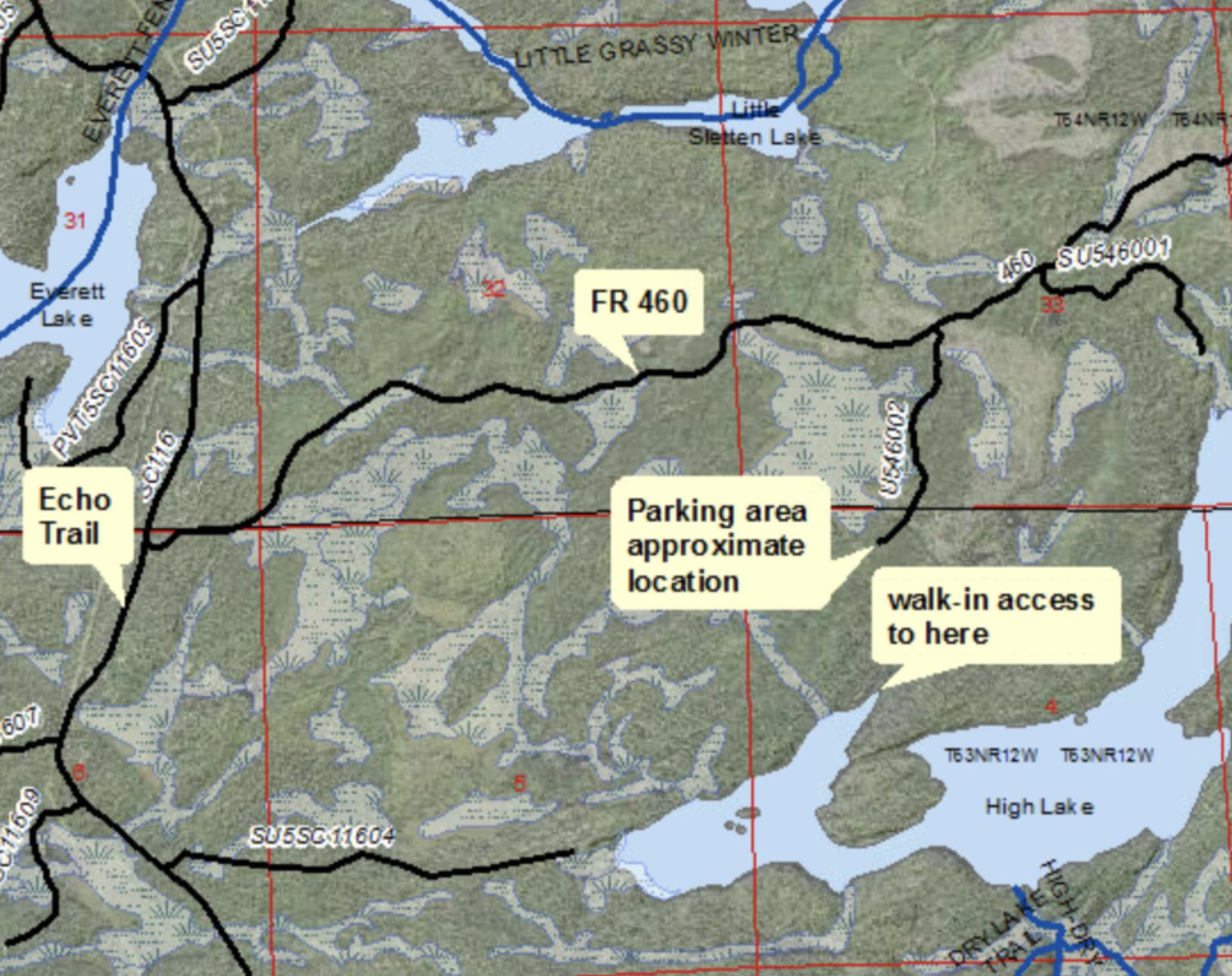
As far as I can tell the plan is simply to improve the existing portage from the north off Forest Road 460. This is the "approximately one mile portage" listed 2nd on the DNR lakefinder page for High, mentioned above by Bush Pilot. From the map shared with me it looks like they intend to turn that portage into a road that terminates in a parking lot about 1/3 of a mile from the far NE bay of the western basin.

First off, if it matters -- this was not the forest service's idea, but the DNR's. The DNR approached USFS with the project. The USFS did an environmental analysis and approved the project, but the DNR is still very much in charge. As one USFS employee told me "our intention is to let them fund it. It’s on their plate as far as I know." I've reached out to the DNR to try to get some kind of a time-table for the project and any additional details they can offer.
As far as I can tell the plan is simply to improve the existing portage from the north off Forest Road 460. This is the "approximately one mile portage" listed 2nd on the DNR lakefinder page for High, mentioned above by Bush Pilot. From the map shared with me it looks like they intend to turn that portage into a road that terminates in a parking lot about 1/3 of a mile from the far NE bay of the western basin.
10/23/2019 07:58PM
Steve Johnson still lives at his High Lake "village". He's a back-to-the-land guy that's lived out there for years and years. I think he's improved his Echo Trail access to the point that he can run a four wheeler. For most of the time he's lived there he carried almost everything out himself. Lives as much as he can by what he can grow, gather or hunt. Built his own little shanty town by salvage and harvest. Interesting guy. Guides in the summer for Piragis but I think this might be his last year.
Nobody exists on purpose, nobody belongs anywhere, everybody’s going to die.

Subscribe to Thread
Become a member of the bwca.com community to subscribe to thread and get email updates when new posts are added. Sign up Here
Community Links
 Search BWCA.com
 Donate
 Featured Sponsor
