bwcadan: "I am interested and have a question too. A sister in law says that "there is an edge to every storm". I think she is referring to the actual precipition area as the storm passes by. Meaning that if two people were walking down the side walks on either side of a street, only one would get any drops/flakes. How do you define an edge of a storm. Info regarding size of a storm and any records of sizes for storms small or large would be interesting to me as well.
I think basically what you are referring to is a "front"-- most likely cold fronts but sometimes MUCH less likely warm fronts or even occluded fronts. I would define the edge of a storm (think a summer thunderstorm ) as the following--- warm air being shoved out of the way by cooler air (this is a classic cold front and reason for A lot (though not all by a long stretch ) a LOT of weather and precip. But I can't delve too deeply here without likely making this question out to be too confusing so will focus on "cold frontal precip".
The reason for the cut off from one side of the street to the other is simply movement of air masses- and, air pressure. It takes time for any air mass to move a "distance" and show force - cold air advection (movement of a colder air mass to an area with a warmer air mass at the surface-- but please remember this not only goes on at the surface, but also elevated) but to keep the matter as simple as possible lets just focus on the surface- or where humans live. Basically what's going on in a cold front is denser air (cold) and comes in like a wedge under the warmer air and thus producing clouds/precip from the upwelling of the warm/moist air. (basically clouds) Depending on the severity of the cold moving in vs. warm AND the upper levels of the atmosphere will determine the severity of the "weather" produced. For this question - again- lets just focus on the surface cold air moving UNDER the warm air. There will be a "front" and literally you are correct for a certain amount of time- one side of the street will see nothing and the other side see precip. Obviously many variables involved in this, but most important would be the speed of the cold front. And this is not linear and involves A TON of atmospheric physics - but on a weather 101 level, since a cold air advection is "making" the precip - and moving into warm air at a certain speed, you WILL see one side of the street see the precip-weather, before the other side. But it's nearly certain the other side of the street that saw no weather is about to VERY SOON. In my 25 years of weather and observing , I've seen MAYBE 1-2 times the precip actually stop and retreat from where it came from. That would be an occluded front and a strong sign that the storm system is weakening. I hope this helps. This is most likely in the winter- not summer for reasons that I will not get into on here.
As far as sizes of storms- or just think of a "disturbed atmosphere" with a lot of junk going on under the clouds (precip,wind.pressure changes etc). The largest storms on earth are mid latitude cyclones. They FAR outdo tropical cyclones (Hurricanes) in the amount of land/ocean/humans affected. One of the largest that I know of was the 1993
Storm of the Century -- this 1993 event pushed me more to go into weather as a career. It moved me.
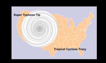
But for Tropical Cyclones - and "maybe" stronger with actually "energy" taken from the atmosphere and put into action compared to mid latitude cyclones the largest/powerful on sf miles affected is Typhoon TIP in 1979 -- she was a beast and if i had to vote for actual energy dissipated (power)- it's TIP- but 95% of Typhoons/Canes are not like this -- many more mid latitude cyclones ( due to #) cause more havoc than Tropical systems- but TIP is an atmospheric marvel --
Typhoon Tip
 Boundary Waters Quetico Forum
")


 Search BWCA.com
 Donate