|
 Boundary Waters Quetico ForumGroup Forum: Woodland Caribou Provincial ParkWoodland Caribou Fires:
|
Author
Text
")


07/03/2021 05:31PM
CLOSURE UPDATE: As RED16 continues to grow, the following routes have been closed: Artery Lake, Mary’s Lake, Barclay Lake. The Artery Lake access point is also closed. Sabourin, Thicketwood, Dutch River, and Bigshell Lake routes continue to be closed. For up to date forest fire information, please visit www.ontario.ca/page/forest-fires
Woodland Caribou Provincial Park
YestiSmSteprodoSenaeys cactuonmmrrfr 4hunemd:f5g6 PM ·
Updated Closures - HAGGART and LEANO Zones closed effective July 2nd at 17:00 CST. The East, Mid Central, and Gammon Zones continue to be open. Paddlers please be advised to check www.ontario.ca/pages/forest-fires.
07/04/2021 08:04AM
https://cwfis.cfs.nrcan.gc.ca/interactive-map Interactive canada fire map (select overlays) for info
You can see specific days on this map. Click in fire perimeter to see size. Musclow increased almost 50 percent in a day. Entering recent burn areas does not seem to be slowing the spread of either fire.
You can see specific days on this map. Click in fire perimeter to see size. Musclow increased almost 50 percent in a day. Entering recent burn areas does not seem to be slowing the spread of either fire.
https://www.youtube.com/user/TheNorthwoodsman1
07/05/2021 08:47AM
...thanks for showing fire maps/and past histories of fire...We have noted on Welkin Lake areas where the 2006 landscape was burnt again in a more recent fire....it will be interesting to watch the large fire in the southwest corner as it moves up the west shore of Talon as that received burns in past histories...our first WCCP experience was in 1989 as we paddled from Red Lake to Lake Winnipeg via the Gammon/Bloodvein...fire in the Optic/Telescope region and Rostoul/Hansen area was from the previous years...we've been back to the WCCP yearly since that first experience, spending time pondering fire directions, regrowth, bird/moose/caribou tracks, and overeating blueberries... 
07/08/2021 05:59AM
So hard to look at the fire map and see that much burning. I count 13 separate fires inside the park's borders.
Seems like the northern limiting factor for the big one in the SW is the 2016 burn.
I had wanted to see Irregular lake, as only a small part of its vast shorelines had burned in 2016, but if the map is correct it's now 100%, including all of its dozens of islands.
Seems like the northern limiting factor for the big one in the SW is the 2016 burn.
I had wanted to see Irregular lake, as only a small part of its vast shorelines had burned in 2016, but if the map is correct it's now 100%, including all of its dozens of islands.
"I don't care what you believe. I care what you can prove." -Philosopher & Mathematician JJJ
07/08/2021 08:38AM
I am keeping an eye on the unburned NW area from Craven to Walking Stick. If I get back to WCPP that route I did a few times is where I am heading. Long portages and not maintained but a group a few years ago went through and found their way without the GPS tracks.
https://www.youtube.com/user/TheNorthwoodsman1
07/13/2021 09:44AM
hobbydog: "There are not going to be many places left in WCPP that have not burned in the last 5 years. "
Was thinking the exact same thing - 2016 to today, I believe we're well over 50% of the park burned.
The ON fire map reflects significant growth and connecting of separate fires in the north.
Forecast looks like there is no real relief in sight up there, and more temps around 90F.
I'd estimate that ~30% of the park has burned this year.
Marten, Walking Stick seems safe. For now.
"I don't care what you believe. I care what you can prove." -Philosopher & Mathematician JJJ
07/13/2021 12:23PM
I can’t help but wonder why so much of WCPP has burned so recently compared to someplace like Quetico? Does WCPP get fewer fire fighting resources because of the location? Is it just dumb luck, or due to excessive blowdown, or fuel build up due to past suppression success? Does it get more hot, dry winds blowing off the Manitoba prairie? Anyone have any ideas?
07/13/2021 01:08PM
...often one reads about the Woodland being at the edge of the prairie with some of the plants that fit in the prairie...so the climate is warmer and drier even in the normal year. Examples of plants: prairie stemmed golden rod, prairie crocus that give clues to a drier/warmer climate...at times park notes call this place as Prairie Boreal like the forests to west rather than wetter climates to the east...add the events like the snow down of jack pine a decade ago, the pine bark beetles that become active after fires on the surviving trees and one has more fuels for fire. The climate produces the "dry" lightning events that fuel strikes of lightning but little rain...the area is also fairly well drained/the water runs off at a good clip (despite my sampling of knee bogs) with shallower soils/thanks to the events of Lake Agassiz in the last glaciers...then, there seems to a shift to less snowfall over the last decade...while everyone can remember the big years of snow, the years have gradually produced less stored moisture in the form of moisture....fire certainly has been a landscaper for the WCCP but it appears more fuels, less rain, more fronts with less moisture have added more fire....the regrowth of places has always amazed us: in 1989 the hills north of Rostoul were showing granite, now a thick forest of jack pine...our first trip through Aegean brought a lake that had been burnt on the western half...now the jack pines have regrown and spaced out while the east and northern parts are burnt or been hit by pine beetles....Haggart which burnt in 2016?? has a nice regrowth of birch...in late September 2019 we made the comment that fall colors would be a great yellow of birch in the near future...what we have noticed is fire in recent fire like around Welkin/Beamish and from the updated fire maps other places like the west shores of Talon, areas near Optic...some of the areas in the northeast north of Linge towards Big Shell appear to be areas that haven't burnt for awhile so there are fuels from the older forest/lichens of the area...lots of stuff happening...interesting to hear other views 

")

07/13/2021 01:52PM
WCPP is very prone to forest fires as it is a drier climate than Quetico and areas to the east. The Oct. 2012 "Snowdown" event that took down a lot of Jack Pine and took the tops out of more. This weakened the trees and the insects moved in and killed a lot. This meaning a lot more dead wood to fuel a lightning strike. The park has a policy of letting lightning fires burn and not put them out. In extra dry years like this things can get out of hand and then too big to put out. Fire is necessary in WCPP for proper long term management. They need to let some things burn but certainly are not happy about the massive hectares consumed in the last five years. The park is there for the Caribou but this much recent burn is not in their best interest. Lichens of the older forests is what they need for winter survival.
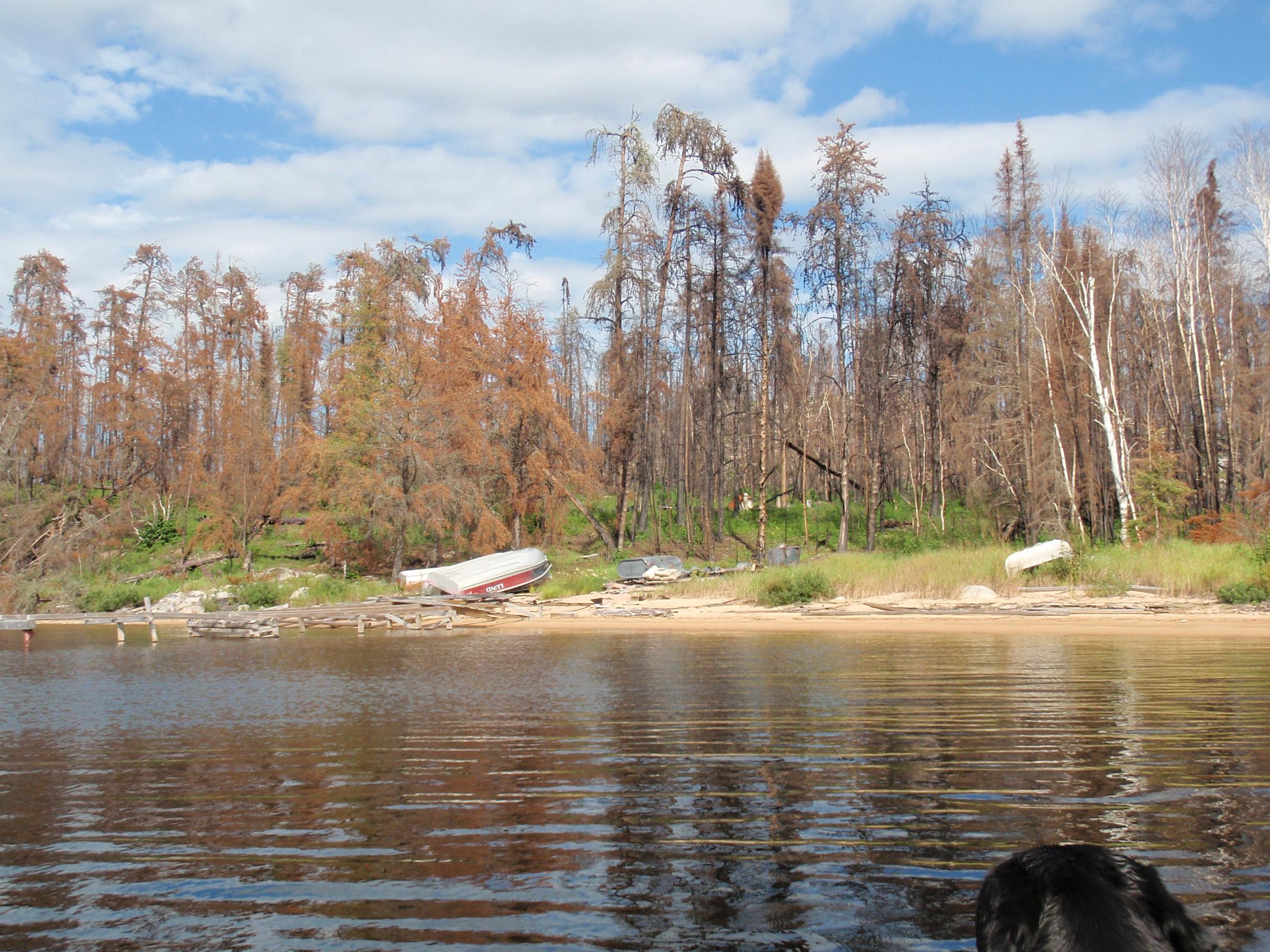
I had hoped that the Craven to Walking Stick area would escape but now see that it will be on fire soon. It was some of the oldest forest that I traveled in up there and was due for a burn. A lake I dubbed "Billy Can" because of a really old camp I came across will be transformed this week. Probably shed a tear as I watch the old video.
Bushwhack through "Billy Can Lake" in NW WCPP.
https://www.youtube.com/user/TheNorthwoodsman1
07/13/2021 04:38PM
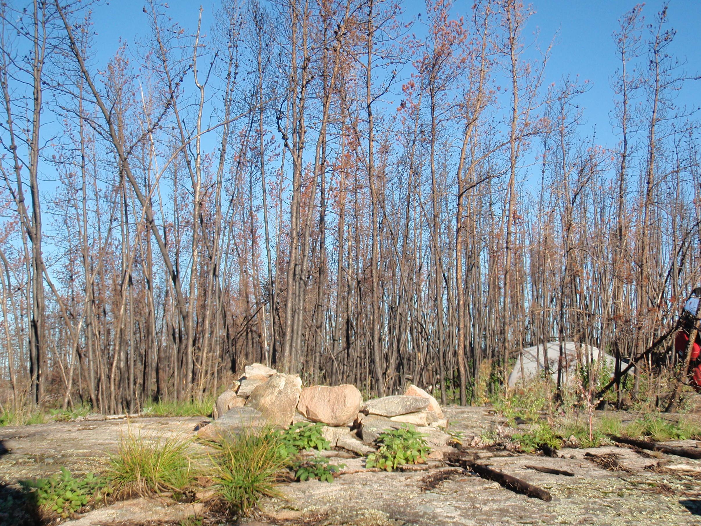
It really is a different type of forest and even without the recent issues mentioned, jackpines by their nature are more susceptible to crown fires. Add snowdowns, beetles and climate change and you get some really hot fires. I was amazed at how hard it burned in the 2016 fire around Haggert Lake. Much of the west is going through the same thing. In my recent trips west, I looked at the amount of pine beetle damage on steep slopes and thought to myself that this will be really bad when it burns . We are seeing that now.
We only see a very short period of time in our lifespans in relation to the big picture. As the climate warms I assume things never get quite back to the way it was. More birch and aspen? Does fire back off for awhile now that so much fuel is gone? Will the park see less traffic with all the recent fires?
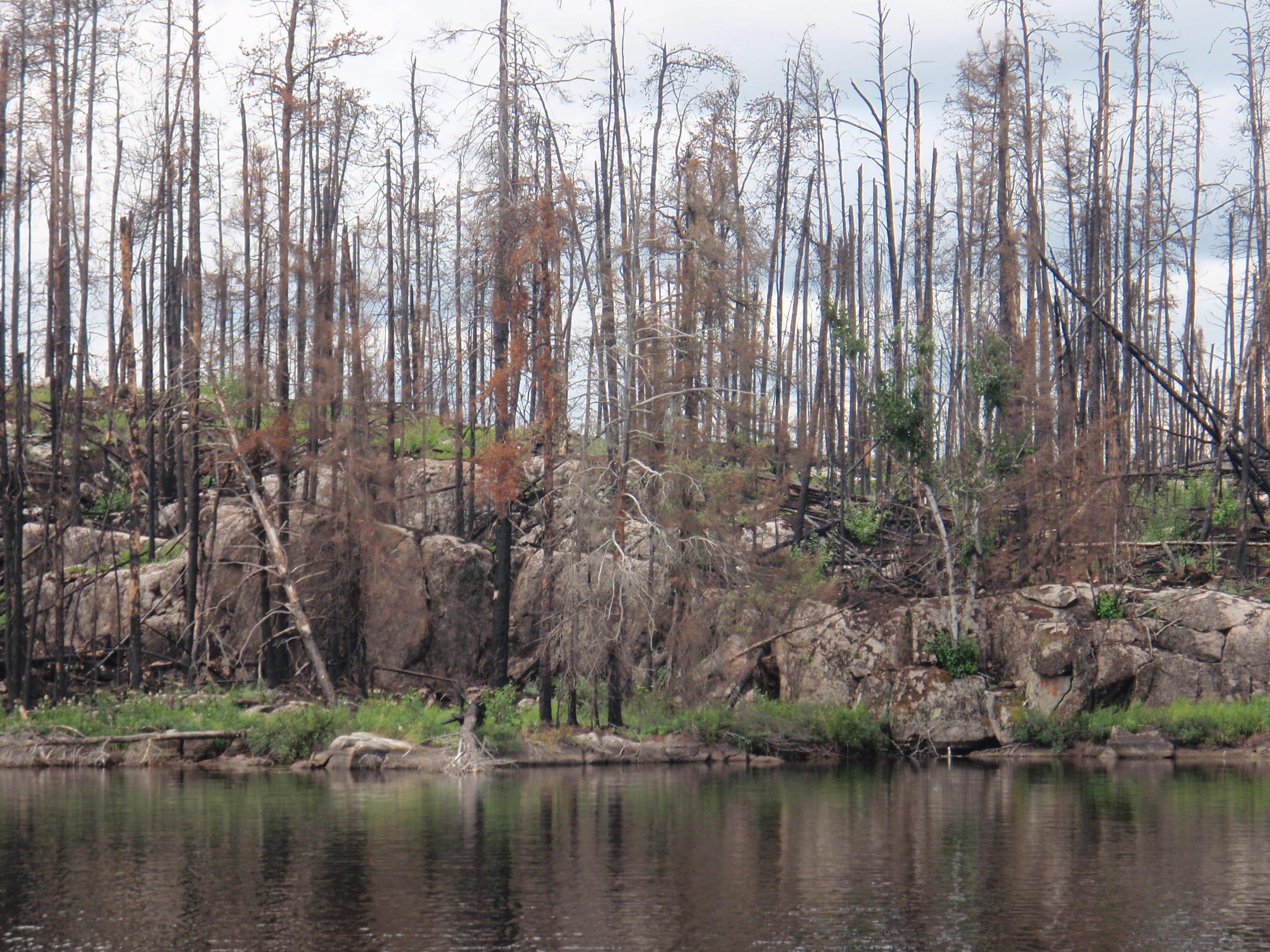
Haggert Lake area fall 2016.

We only see a very short period of time in our lifespans in relation to the big picture. As the climate warms I assume things never get quite back to the way it was. More birch and aspen? Does fire back off for awhile now that so much fuel is gone? Will the park see less traffic with all the recent fires?
Haggert Lake area fall 2016.

The best thing one can do when it's raining is to let it rain. Henry Wadsworth Longfellow
07/13/2021 05:10PM
Marten: "
I had hoped that the Craven to Walking Stick area would escape but now see that it will be on fire soon. It was some of the oldest forest that I traveled in up there and was due for a burn. A lake I dubbed "Billy Can" because of a really old camp I came across will be transformed this week. Probably shed a tear as I watch the old video.
Bushwhack through "Billy Can Lake" in NW WCPP. "
My favorite portage in the park was the 1500 meter from Craven to Ford. I really hope it is spared.

The best thing one can do when it's raining is to let it rain. Henry Wadsworth Longfellow
07/13/2021 07:06PM
hobbydog: "My favorite portage in the park was the 1500 meter from Craven to Ford. I really hope it is spared.
"
That looks a lot like what Albert called the Enchanted Portage, on the south end of Dunstan.
Lovely.
Burned completely in 2018.
If the maps are right (and they're likely at least a little out-of-date) there is fire 2km north of Ford, but the Craven to Ford portage may still live.
"I don't care what you believe. I care what you can prove." -Philosopher & Mathematician JJJ
07/13/2021 09:27PM
sns: "hobbydog: "My favorite portage in the park was the 1500 meter from Craven to Ford. I really hope it is spared.
That looks a lot like what Albert called the Enchanted Portage, on the south end of Dunstan.
Lovely.
Burned completely in 2018.
If the maps are right (and they're likely at least a little out-of-date) there is fire 2km north of Ford, but the Craven to Ford portage may still live."
I did the enchanted portage in 2015, I thought this one was much nicer. Now the 2km one to Artery, that one can burn. It was no fun.
The best thing one can do when it's raining is to let it rain. Henry Wadsworth Longfellow
07/14/2021 08:05AM
Fire map update this morning shows that the east side is now blowing up: virtually the entire Anchor addition to the park, all the way to the western shores of Domain, has burned.
We are getting close to 50% of the park burned in the last 6-7 weeks.
We are getting close to 50% of the park burned in the last 6-7 weeks.
"I don't care what you believe. I care what you can prove." -Philosopher & Mathematician JJJ
07/14/2021 04:57PM
What a day, I do not know what was worse. The routine colonoscopy or looking at the updated fire map. Worst is not seeing any end in sight.
So many "values" meaning outposts and lodges have had the fire move past them that resources have to be spread pretty thin. Next door in Atikaki we witnessed the fire crews coming in and installing gas powered water pumps connected to a big sprinkler head to protect values. When the fire approaches they drop in and start the pumps.
Makes me wonder if they are going to be able to save Harlan's Olive Lake Eco Lodge. Fire is moving in slowly from the east and west. Winds have been fairly light from what I have gleaned from the weather sites. A 50 K wind would turn this into a huge disaster. Hard to imagine breathing all the smoke that has moved past Red Lake this week.
https://www.youtube.com/user/TheNorthwoodsman1
07/14/2021 06:28PM
Sabourin Lodge dodged Red016 in late June (lost two cabins - aerial photos on their FB page show how close it was).
Harlan's place - if the map is current & accurate - is likely within 1km of the fire, as is the Domain Lake outpost & the places on Donald.
The outpost on Thicketwood would have been at risk - map shows it within the burn zone.
Same for Knox Lake & Optic Lake. There's a structure on Burntwood (apt name) in the burn zone but I am not sure if it is a commercial operation.
And several more outposts on border lakes where the outpost itself is outside the park.
:-(
"I don't care what you believe. I care what you can prove." -Philosopher & Mathematician JJJ
08/05/2021 01:02PM
Marten, looks like the NE end of Walking Stick may now be at immediate risk.
I have noticed one aspect of the ON fire map that is confusing:
Mexican Hat, which clearly was ~50% in the burn zone a few weeks back, now is not included. I do not know if this is an adjustment to earlier estimates, or if older fire areas once out are removed from the map. Anyone know? Similarly, the West end of Domain Lake now is not included in the fire perimeter, but it definitely was a couple weeks ago.
"I don't care what you believe. I care what you can prove." -Philosopher & Mathematician JJJ
08/06/2021 09:42AM
I have been using the interactive map link listed above for my daily study of the fires. That link shows all of Canada and works better for me because my new playground has been over in Manitoba's Atikaki park. There are a few differences like the ones you mentioned. When this is over WCPP will probably do as in the past and have a report on fire intensity covering the burned areas. I do note that the area got about 14 millimeter (.6 of an inch) of rain over the last few days. On the map I use there were no hotspots showing at all yesterday. Fire is not out but the rain really tamed it down. More is needed or it will be heating up again shortly. A lot of bulldozed fire line to on the east.
A few of my favorite spots like Joey Lake west of Indian House, Twin Lakes and Moose Lake in the NW and most of Walking Stick will still provide some shade and trees to hang hammocks. My new area of travel in Atikaki has been spared so far.
A few of my favorite spots like Joey Lake west of Indian House, Twin Lakes and Moose Lake in the NW and most of Walking Stick will still provide some shade and trees to hang hammocks. My new area of travel in Atikaki has been spared so far.
https://www.youtube.com/user/TheNorthwoodsman1
08/09/2021 09:33AM
Marten,
This map shows just Ontario but is a valuable resource for me.
Zoom in to 10km or closer to see the 'fires' blow up to the true extent of the devastation!
It is an absolute mess this year. Such a shame that this all happens in one calendar year.
Looks to be almost everything burnt that wasn't already burned from the past 10 years.
A new fire has started in the NW corner above Ted's lake now. Hopefully that can be contained.
Be well, Be safe - plan for next year!
Glen
(mywoodlandjourneys)
Ontario Forest Fire Map
08/09/2021 09:36AM
Hi sns,
If you select “out” fires you will see the fire perimeter around MH and Domain. I guarantee MH and Lower Glenn were hit hard, I saw it with my own eyes in June.
Ian
If you select “out” fires you will see the fire perimeter around MH and Domain. I guarantee MH and Lower Glenn were hit hard, I saw it with my own eyes in June.
Ian
sns: "Marten, looks like the NE end of Walking Stick may now be at immediate risk.
I have noticed one aspect of the ON fire map that is confusing:
Mexican Hat, which clearly was ~50% in the burn zone a few weeks back, now is not included. I do not know if this is an adjustment to earlier estimates, or if older fire areas once out are removed from the map. Anyone know? Similarly, the West end of Domain Lake now is not included in the fire perimeter, but it definitely was a couple weeks ago."
08/17/2021 05:35PM
While it is not showing on the Ontario fire map yet, the FIRMS map shows hotspots on the east side of Mexican Hat. Possible that it is now entirely burned.
"I don't care what you believe. I care what you can prove." -Philosopher & Mathematician JJJ
08/25/2021 07:55AM
While Quetico and the BWCA have missed all the rain areas to the north including WCPP are now much wetter. Manitoba has lifted it last closure of Atikaki Provincial Park.
Manitoba press release lifting travel restriction for Atikaki Provincial Park
Manitoba press release lifting travel restriction for Atikaki Provincial Park
https://www.youtube.com/user/TheNorthwoodsman1
08/25/2021 10:13AM
If you need a place to paddle with all the changes this summer I offer you this report on Atikaki Provincial Park in Manitoba. Accurate maps are not available and the official park map is only useful for general route finding. At this trip report you can download my GPX file of my info for Atikaki. It contains all my info for Atikaki Provincial Park from all my trips there.
NOTE THAT IF A WAYPOINT NAME HAS A "?" MARK IT MEANS I HAVE NOT BEEN TO THAT PORTAGE TO VERIFY IT. All others I have traveled through and the portages were open. Atikaki trip report with GPX file you can download
NOTE THAT IF A WAYPOINT NAME HAS A "?" MARK IT MEANS I HAVE NOT BEEN TO THAT PORTAGE TO VERIFY IT. All others I have traveled through and the portages were open. Atikaki trip report with GPX file you can download
https://www.youtube.com/user/TheNorthwoodsman1
09/05/2021 09:39PM
Awesome info Marten!
I was resigned to do BWCA this fall and then it, too closed. I should add that Wabakimi is also another place to explore, I'm headed there for the first time next week. It might have been a lot busier this summer! But like WCPP, it only gets about 700 paddlers a year, and from Duluth it is only 30 miles farther away than WCPP.
The area of my next trip to WCPP didn't get hit too bad this summer, so next spring I will have the difficult decision, do I return to Wabakimi, WCPP, or try some of the northern entry points in Quetico? Don't think I will get the RABC permit and do southern Quetico again for awhile...
But WCPP, man those fires! I can't believe Wrist burned again. When I was there last, there was a super thick regrowth of 6-10' jack pines. We camped on a rock there in 2018 and the island site in 2019. The portage to Jigsaw was hard to find and follow due to the previous fire (and mismarked on a map) . And now it burned again! Wow. We built and rebuilt a lot of cairns on burned portages in 2019 and it's crazy it burned again. But the previous burns in that area left a lot of fuels 3" and up still on the ground to burn again.
Joe

Subscribe to Thread
Become a member of the bwca.com community to subscribe to thread and get email updates when new posts are added. Sign up Here
Community Links
 Search BWCA.com
 Donate
 Featured Sponsor
