|
 Boundary Waters Quetico ForumListening Point - General Discussion Mapping software
|
 Forum Sponsor

Author
Text
")

06/06/2023 01:09PM
Does anyone use mapping software to document their trips? I would like to be able to see all of the past trips I have done on one map so I can plan for areas I have not visited. Bonus if I could click on individual past routes and upload notes/pictures. Similar to the trip reports section of this site, but with mapping included. I use a SPOT beacon, but don't find the included mapping to be what I am looking for. Any suggestions?
Thank you!
-jmchev
Thank you!
-jmchev
06/06/2023 04:32PM
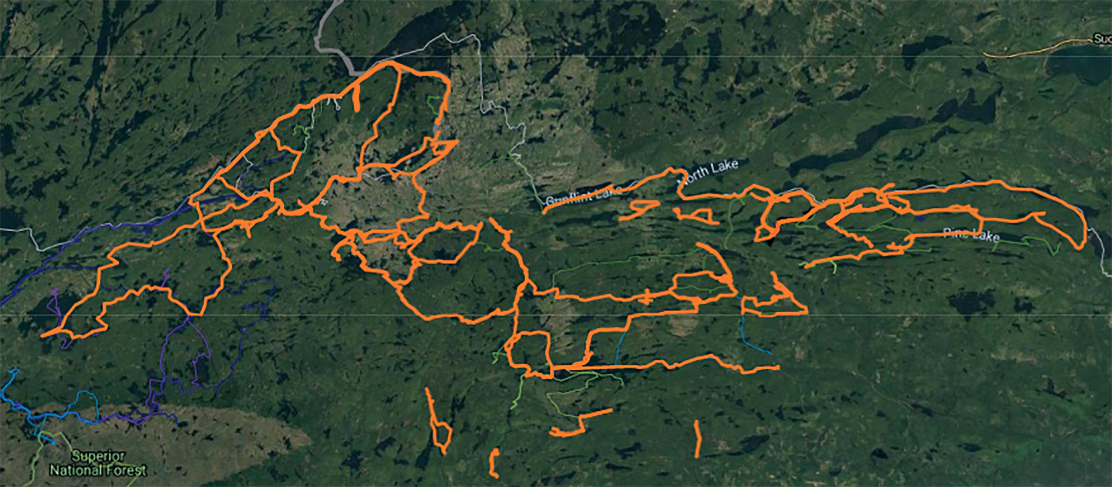
It's far from perfect, but I keep mine in google my maps. I color code it then by year and make a segment for each travel day so I can track number of travel days to a season. It responds reasonably well to file uploads so I have placed the bwca boundary on it as well as campsites and entry points. 
"Once you have heard the music of the Boundary Waters, you will yearn for it until you can yearn no more." - Miron Heinselman

06/06/2023 07:39PM
I do this with Google Earth Pro (the desktop app, not the web app). Easier than learning how to use GIS software like ArcGIS or QGIS. It will let you upload tracks, add notes to said track, upload waypoints and pictures, add additional map layers, and even more.
Bonus is that you can also add portage and campsite locations. It's my all-in-one tool for trip planning.
Bonus is that you can also add portage and campsite locations. It's my all-in-one tool for trip planning.

09/21/2024 02:48PM
I really hate contributing to the delinquency of the digitally-addicted. ;-)
But I am compelled by a humanitarian spirit to point out a feature in QGIS that I just stumbled onto, after using the app for more than a decade. You can generate a georeferenced PDF map (usable in Avenza and the like) with a couple of mouse clicks, once you have created the map in QGIS.
QGIS is available here (I am not available for tutorials):
QGIS homepage
Ignore the title of the following query. A response actually contains a straightforward description of the process for creating georeferenced (geospatial) maps:
No option to make GeoPDF from layout view in QGIS
09/23/2024 08:45AM
mhart: "I've used onX hunt maps on my iphone before. It allows you to track, place waypoints, etc. You can download the maps ahead of time so you can use it offline. The maps show campsites and portages. "
Just in case you are like me and have used onX as a free user, they have gone to a pay-only system now as of just a few weeks ago. You can still see your old tracks, waypoints, etc, but you can't interact with them in any way or add any new points or use offline maps without paying the annual fee.
")

09/23/2024 10:14AM
I use a Garmin InReach unit. Each day when on a trip I start the tracking feature and that does a few things. This summer this was a critical feature that I used for my fishing trip in central Ontario. We fished a different lake each day that we drove to on dirt logging roads. So many turns to get lost on these roads. But with the InReach I could leave a breadcrumb trail to follow back to camp. I also could see exactly where I was fishing or stopping for a shore lunch. After the trip I save the tracking points and label it for later viewing on my iPad in the Garmin Explore App.
"So many lakes, so little time." WWJD
09/23/2024 05:22PM
I've been preparing my own maps with google earth for a long time. Since I started learning ArcGIS a few years back I've been using that to make more complicated maps. I've also started exploring OnX Backcountry (its like OnX Hunt, but marketed to non-hunting recreation users) and I like it. I've traded out my Gaia sub for an OnX one. You can get data from a lot of places. The Minnesota Geospatial Commons is a great place to get data layers, as are ESRI and you can even pull layers off of Open Street Map for use in your program of choice.
Thanks, Takk
09/25/2024 08:46PM
jmchev: "Does anyone use mapping software to document their trips? I would like to be able to see all of the past trips I have done on one map so I can plan for areas I have not visited. Bonus if I could click on individual past routes and upload notes/pictures. Similar to the trip reports section of this site, but with mapping included. I use a SPOT beacon, but don't find the included mapping to be what I am looking for. Any suggestions?My software for planning and archiving BWCA trips.
Thank you!
-jmchev"

Subscribe to Thread
Become a member of the bwca.com community to subscribe to thread and get email updates when new posts are added. Sign up Here
 Search BWCA.com
 Donate