|
 Boundary Waters Quetico ForumListening Point - General Discussion Forest Fire Recovery
|
 Forum Sponsor
Author
Text
")


05/08/2025 09:42AM
For those that know more than me. What does recovery look like. I was just looking at JAP (now Paulsen) lake on Google Earth. JAP was previously one of my favorites (pre-fire), but alot of the scenic value is lost now in my opinion. Anyways I was curious about the forest recovery. From the the satellite images on Google Earth - it looks like there's been no recovery. Why? Is there a period in forest recovery where it seems to get worse first? What's the typical timeline? Pictures Below
2003 JAP Lake - Pre Fire
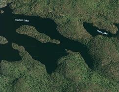
2011 JAP Lake - 4 years post fire

2020 JAP Lake - 13 years post fire

2003 JAP Lake - Pre Fire

2011 JAP Lake - 4 years post fire

2020 JAP Lake - 13 years post fire

"When used separately, women and alcohol can be a lot of fun. But if you mix them, they can turn you into a dumbass." - Red Foreman
05/08/2025 09:42PM
As I believe Amarillojim was implying, the timing of season for the photos can make a huge difference in what you see. The 2003 looks to be a late spring-early summer photo. The 2011 is an early spring "leaf-off" photo. Bright minty green = leaves just opening or fresh growth in wet grassy areas. Short young trees with few branches and leaves just starting to open up have made exposed rock surfaces are readily visible in that one. I don't have my glasses with me now but the last one looks like the color or brightness of it needs to be touched up a bit or maybe it is part of a series taken when photo conditions weren't so great. Air photos are fascinating.
05/09/2025 06:56AM
I travel a lot to the French River in the north part of Georgian Bay in Ontario. It's an area that was devastated by a large wildfire several years ago. Ironically this fire was caused by a machine used to build a wind farm. This area is much more rocky than Quetico. It's characterized by a lot of bald granite with islands of Juniper bushes. I always wondered how those islands formed in seemingly bald granite but never gave it much thought. On inspection after the forest fire, these bushes were completely burned away exposing shallow mounds of 1 ft sized stone. Obviously the debris gathers in there and transforms into enough soil for the juniper plants to germinate.
Not really germaine to your question but an interesting side note on how these areas were naturally formed.
Not really germaine to your question but an interesting side note on how these areas were naturally formed.
05/09/2025 07:17AM
The second two post fire are spring April and May. More so I was looking at the lack of tree growth. There's basically not difference from right after the fire to approaching 20 years later. I would have expected to see more tree growth...and it's basically the same.
Paddling the greenwood fire area, which is more recent, there's been no recovery. Pagami is mixed, like Egknuti noted. There are areas where I see more regrowth and areas where not so much.
You might be on to something, the intensity of the fire likely plays a role. Some of my absolute favorite areas have burned in the last 20 years and i'd love to see them start getting back...unfortunately probably not in my lifetime.
"When used separately, women and alcohol can be a lot of fun. But if you mix them, they can turn you into a dumbass." - Red Foreman
05/09/2025 08:13AM
Kinda related, I've seen lots of re-growth in the Little Sag/Crooked Lakes area in the last 15 years. Its starting to look likes its old self again.
"Miller owns that field, Locke that, and the Mannings the woodland beyond. But none of them owns the landscape." - R.W.Emmerson.
05/09/2025 02:25PM
If there is no substantial regrowth years down the line, it is usually a function of fire intensity. Some fires can burn so hot, they literally incinerate most or all of the topsoil, particularly in areas where the soil layer is thin to begin with. For instance, there are old burn scars in the Wyoming and Colorado mountains I'm familiar with that have little reforestation 20 years later, while nearby spots in the same burn area and at the same elevation, aspect, etc. have some regrowth. If there is lack of regeneration years later, I bet fire intensity and impact on soil is a likely candidate.
Disclaimer - not a forester or botanist or anything like that, just based on what I've read and observed. Compounding my likely ignorance is the fact I've never been to BWCA or Quetico! But that oversight is soon to be remedied - leaving for first canoe country trip to Q 4 weeks from right now!
Disclaimer - not a forester or botanist or anything like that, just based on what I've read and observed. Compounding my likely ignorance is the fact I've never been to BWCA or Quetico! But that oversight is soon to be remedied - leaving for first canoe country trip to Q 4 weeks from right now!
05/10/2025 04:46PM
After the Ham Lake fire in 2007, I was doing volunteer rebuilding work at Wilderness Canoe Base Camp near the end of the Gunflint Trail. I was there for about a week in October of that year. At the same time, we met a PhD student in forestry from the U of MN who was setting up some research sites on burned over locations on camp property. As I recall, he was planning to do an extended study on early forest regeneration after a fire. I wish I had followed up on his findings which would have been interesting.

Subscribe to Thread
Become a member of the bwca.com community to subscribe to thread and get email updates when new posts are added. Sign up Here
 Search BWCA.com
 Donate