|
 Boundary Waters Quetico ForumGroup Forum: Woodland Caribou Provincial ParkMexican Hat lake help
|
Author
Text
")

06/26/2012 04:13PM
Our group will make it's first WCPP trip next June. As of right now it looks like a Leano entry with a Mexican Hat base camp and then day trip in different directions from there. I do have a few questions, if you guys will oblige.
1. Mexican Hat lake would compare in size to what BW lake.
2. Travel time from Leano to Mexican hat under the average conditions.
Thanks in advance. We are not totally committed to a route and the possibility of a fly-in paddle out route is for sure on the table. Primary goal is to get a good feel for WCPP and sample all the different kinds of fishing.
06/26/2012 08:07PM
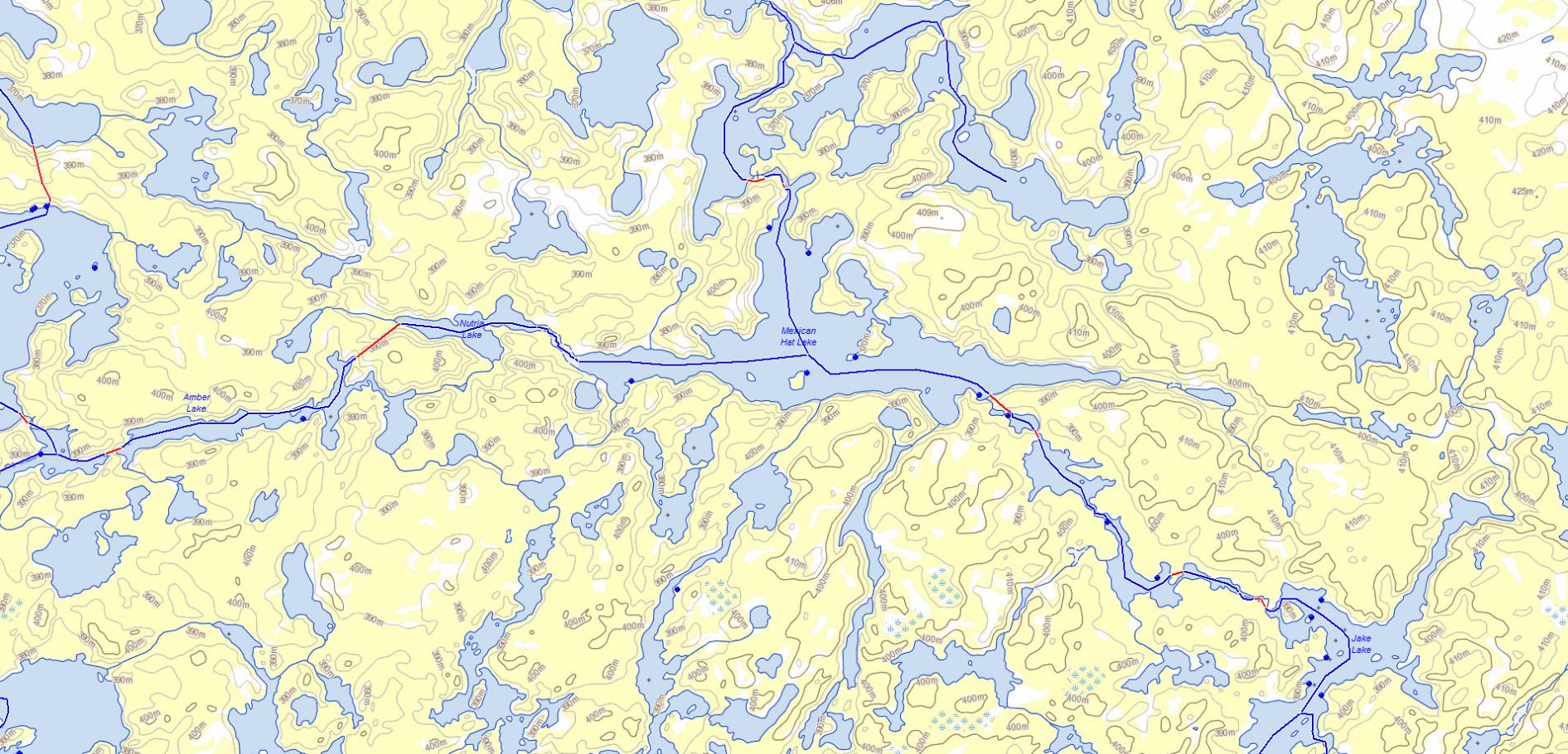
Mexican Hat is about 3 miles long, so it's on the order of Fourtown or Parent.
It's about 15 miles from the Leano entry. It's definitely reachable in a day, though it depends on your motivation level, experience, and the weather. Obviously you would need to camp somewhere close the night before, as you're not going to be able to drive 70 miles of bad road and then make 15 miles in a canoe. I tend not to go so far on my first day but that's just me (and my family).
There's quite a few short portages. None real difficult, but the landings are challenging, at least when I've been there. They kind of wear you down as well.
Enjoy your trip!
")

06/26/2012 10:14PM
Kanoes is Correct, It is about 45 miles to Leano Entry. The first 10 miles or so not so bad, the last 35 can be rough depending on the weather, prior to or during your drive!
I would say stay on Lunch Lake or Jake Lake.
Lunch Lake has 3 good sites, the best one is on the Island in the Middle of Lunch Lake.
Watch your EXIT off Lunch Lake on way to Jake Lake, you come around a corner and have to vear to the RIGHT, You will hear a gigantic waterfall, and It is a bit of a tricky landing.
Jake Lake has 5 campsites, The best one is on the Big Point Sticking out on the Middle West side. If you make it to here, that is a good distance for day 1 in my opinion.
It is so beautiful, that I would take my time and soak up the beauty!!
There are several nusisance (short) portages and small waters after Jake Lake on way to Mexican Hat. Bing, Bing Bing all in a row.
The campsites on Mexican Hat are one right across from the waterfall, A+ Site, and one on a point on middle of lake on the North Side.
Wind should not be much of an issue as the trip to Lunch Lake, is pretty protected waters for the most part. If water levels are good, do yourself a favor and paddle to the WEST end of Mexican Hat, and go into Nutria Lake, If water level's are shallow it can be a bear, but if water levels are good, go do it...It is a BEAUTIFUL secluded little lake, worth many photo's.
Have Fun and email me if you have questions
SunCatcher
"WWJD"

06/27/2012 07:49PM
quote marsonite: "Is it 45 from Red Lake? I was measuring from Ear Falls (skipping Red Lake), and I guess the whole 70 isn't bad. At any rate, 45 or 70, it'd take more energy than I have to drive that road and then paddle/portage 15 miles. "
I think the road from Ear Falls is getting to bad to travel. Besides, your going to want to visit Harlan's hardware/ sports shop in Red Lake. The days of taking little toyota cars in there are over I'd say. No one is maintianing the road anymore except maybe a resort or two up to their place. Harlan put a lift kit in his truck for the trips out to Leano.
Nctry
06/27/2012 09:37PM
quote nctry: "quote marsonite: "Is it 45 from Red Lake? I was measuring from Ear Falls (skipping Red Lake), and I guess the whole 70 isn't bad. At any rate, 45 or 70, it'd take more energy than I have to drive that road and then paddle/portage 15 miles. "
I think the road from Ear Falls is getting to bad to travel. Besides, your going to want to visit Harlan's hardware/ sports shop in Red Lake. The days of taking little toyota cars in there are over I'd say. No one is maintianing the road anymore except maybe a resort or two up to their place. Harlan put a lift kit in his truck for the trips out to Leano."
good info! so i have to beg to get my wifes tundra again, for next spring? :)
06/28/2012 06:09AM
quote nctry: "quote marsonite: "Is it 45 from Red Lake? I was measuring from Ear Falls (skipping Red Lake), and I guess the whole 70 isn't bad. At any rate, 45 or 70, it'd take more energy than I have to drive that road and then paddle/portage 15 miles. "
I think the road from Ear Falls is getting to bad to travel. Besides, your going to want to visit Harlan's hardware/ sports shop in Red Lake. The days of taking little toyota cars in there are over I'd say. No one is maintianing the road anymore except maybe a resort or two up to their place. Harlan put a lift kit in his truck for the trips out to Leano."
That's really a shame. My last trip up there was something like 4 years ago and I drove it in a Honda Civic.
06/28/2012 10:36AM
We are leaving for that trip in just 21 days!!!
We'll be staying in Red Lake the night before put in, and then Harlan is going to shuttle us in his truck.
Thanks for campsite tips!!
We'll be staying in Red Lake the night before put in, and then Harlan is going to shuttle us in his truck.
Thanks for campsite tips!!
LNT - The road to success is always under construction. http://hikingillinois.blogspot.com/
07/02/2012 12:45AM
Making Mexican Hat in one day would be a lot of work, there are many portages, and you'd miss camping on the best lake along the route IMO, Jake, attempting it would detract from enjoying the area, this is not the BWCAW where you are racing to get away from the put in and everyone else, you'll be lucky to see anybody else, consequently, flying in to Mexican Hat makes no sense to me, you'd be paying to fly into the crowded area (by Woodland standards) and avoid the truly secluded area, which is the perimeter, the crowded areas are the main river area to the north of Mexiacn Hat, the lot at Leano was empty when I put in, there were two other vehicles when I left. There were planes constantly flying to the river system.
I don't think there is much difference in road conditions between Ear Falls & Red Lake, the advantage coming from Red Lake is that it is 25 fewer miles of washboard. The drive from Ear Falls to Red Lake is nicely paved and pleasant.
I don't think there is much difference in road conditions between Ear Falls & Red Lake, the advantage coming from Red Lake is that it is 25 fewer miles of washboard. The drive from Ear Falls to Red Lake is nicely paved and pleasant.
let science, not politics decide, ... but whose science?
07/02/2012 07:47AM
I really wasn't considering flying in to Mexican Hat lake. The fly in option would be to a lake somewhere else. I meant that as more of a statement that we are non committed at this point as to where we go in the park.
Mexican Hat seems like a logical lake to base out of due to the distance from Leano. However since we are driving 16 hours to get there, I am certainly not limiting myself to a set idea of what is to be. Nor is a 250.00 flight going to be an issue from keeping us out of a great area.
So with all that said, where would you suggest for walleye and lakers with good seclusion. We are not interested in seeing boat traffic or airplanes all day.
07/08/2012 01:05PM
OK! I just finished printing a set of MNR LIO 1:49000 topo maps of our entire route.
If anyone wants, you can look here and play around with it.
Ontario MNR LIO Make-A-Map
If anyone wants, you can look here and play around with it.
Ontario MNR LIO Make-A-Map
LNT - The road to success is always under construction. http://hikingillinois.blogspot.com/
08/15/2012 11:54AM
quote jcavenagh: "OK! I just finished printing a set of MNR LIO 1:49000 topo maps of our entire route."
Actually, I prefer Toporama maps downloaded from
GeoGratis:
Of course, the downloaded maps don't have any portage or campsite markings and they are in a green tint (rather than yellow, which I find easier to read through a map case), but they do have the requisite detail.
dd
"If you can keep your head when all about you are losing theirs" chances are you missed something. (Inspired by Rudyard Kipling.)

Subscribe to Thread
Become a member of the bwca.com community to subscribe to thread and get email updates when new posts are added. Sign up Here
Community Links
 Search BWCA.com
 Donate
 Featured Sponsor
