|
 Boundary Waters Quetico ForumGroup Forum: WabakimiGrahman road to Wabakimi
|
 Forum Sponsor

Author
Text
")

09/06/2014 04:20AM
Just got back from trying to get into Wabakimi from off the Grahman road, can't be done folks, very large gapping hole where the road used to be, seems someone with a large piece of road construction equipment removed a section of the road. I have'nt been in that area for about 5 years but I think we were about 3-5 miles short of the portage into the north end of Harmon lake, which dumps into Wapakamski. The BrightSands river goes west on Wapi then turns into AlanWater river at the rail crossing at Alan Water station. Next year we will go into the Brightsands River at the BrightSands bridge, portage into the south end of Harmon then go north through Harmon to Wapi. FRED
Grant me the senility to forget the people I never liked, the good fourtune to remember the ones do, and the eyesight to tell the differance.

09/09/2014 02:52AM
I dont have my maps at work but I do believe the BrightSands bridge is south of Little Sparkling lake. I did some really in depth looking at maps and talking to my Brother-in-law [who has made a lot of trips to the north end of Harmon Lake] and he was pretty sure we overshot the short logging road that take you to the portage into the north end of Harmon Lake probably 3-4 miles, but on the way back to the Bright Sands I never saw a logging road that was well used or any of the roads looked familar, we even walked a couple for aways and they were'nt the right ones. FRED
Grant me the senility to forget the people I never liked, the good fourtune to remember the ones do, and the eyesight to tell the differance.
09/09/2014 02:53PM
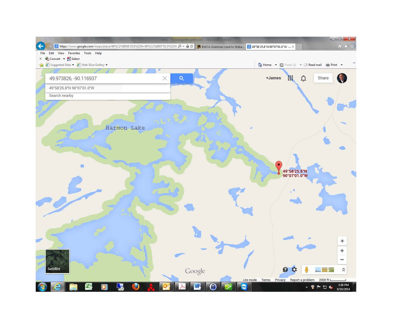
Were you looking for the Harmon Lake boat launch at 49.973826, -90.116937?
I see a photo linked to that spot on google maps.
It looks to be about 27 miles to Allenwater Bridge outpost.
Have you left your vehicle here in the past?
Is there a spot to park?
This intrigues me.
I see a photo linked to that spot on google maps.
It looks to be about 27 miles to Allenwater Bridge outpost.
Have you left your vehicle here in the past?
Is there a spot to park?
This intrigues me.
LNT - The road to success is always under construction. http://hikingillinois.blogspot.com/
09/10/2014 02:37AM
The boat landing I think your refering to goes into Harmon towards the southern end, we were looking for the logging road that leads to the portage into Harmon that is actually on the further northeast corner of Harmon,then it's a 5-7 mile paddle, shoot or portage a short rapids and your into Wapi [which is were we were going] FRED
Grant me the senility to forget the people I never liked, the good fourtune to remember the ones do, and the eyesight to tell the differance.
09/10/2014 08:01AM
It is 6 miles from the coordinates I got from google into Wapi. Google maps has a mileage measuring tool. The Graham road seems to pass about 1000 feet east of Harmon Lake at that farthest northeast point.
Have you left you vehicle parked there for extended period of time?
Have you left you vehicle parked there for extended period of time?
LNT - The road to success is always under construction. http://hikingillinois.blogspot.com/
09/10/2014 10:18AM
quote FOG51: "Next year we will go into the Brightsands River at the BrightSands bridge, portage into the south end of Harmon then go north through Harmon to Wapi."FRED: Organizers of The Wabakimi Project would welcome the opportunity to assist you in route planning for next year's trip. Contact "Uncle" Phil (pjcotton@tbaytel.net).
09/10/2014 10:53PM
That is the spot I was looking for, there is an old logging road that goes west about a quater mile to a portage [around 1000 feet or so] that goes down into that bay on Harmon Lake. The portage is good and wide with lots of rocks, some mud and a fairly steep hill at the bottom. In the 80's and early 90's we pulled our boats down to the lake with our 4wheel drive trucks, the last few years we went we used our ATVs. I missed the road because I had'nt been there for 5-6 years and the woods reclaims itself pretty fast up there. I'm toying with the idea of going back to Wapi the first week of October,probably going solo any intrest in going? For years we left our trucks parked in the bush and only once had them bothered and that was the time we were portageing in and a large group of fathers and childern from the cities were going out, when we got back to the truck all our canoe tie down ropes were gone from in the topper [couldn't lock it] not saying they took them but our ropes were gone and so were they. I left my truck at the BrightSands bridge last week for 8 days. FRED
Grant me the senility to forget the people I never liked, the good fourtune to remember the ones do, and the eyesight to tell the differance.
09/11/2014 07:43AM
Fred - Thanks for asking, but October is no good for me. I have commitments to my son's marching band. I am on the board of the band boosters and that is their competition season.
I am just surprised to find that a road can get you just about right to the water. I am thinking about maybe trying it in July or August. Wapi is pretty big water. I am intrigued by maybe going up through Allanwater and into Wabakimi for a few days. But I am not sure I can do it next year.
I have a white water rafting trip that a buddy is putting together next summer somewhere out west, Colorado, Snake, Columbia or something along those lines. I have to see what the timing is on that and then I can think about something up north.
LNT - The road to success is always under construction. http://hikingillinois.blogspot.com/

09/13/2014 08:43PM
quote HighnDry: "Wabakimi in October sounds interesting. Wonder if the weather will hold?"
The weather would likely be quite cool. In September it often starts to cool markedly. However, Uncle Phil once told me the latest he had ever paddled in the Wabakimi area was in November. So I suppose it could be possible with the right conditions.
09/13/2014 08:50PM
We spent 8 days on the BrightSands about 3 weeks ago and saw one small fishing boat on B.S. and one canoe at one of the rapids, the canoe folks appeared to be daytripping as we did'nt see any packs just a big red dog. There is 2 boats chached on Robert Lake but they have been there for years and the portage was close to being grown over. The Rude to BS portage showed signs of being used lightly. There is a fly-in lodge on Montairy and their fishermen do rarely travel onto the B.S. Considerable less trafic than 10 years ago. The island campsite we used to use now has a 3 foot bush growing beside the firepit. I think the B.S. River is still used fairly heavily in the spring by the locals, but they usually camp before the falls ,portage their boats to the bottom and walk back and forth to camp each night....So my answer is yes you will see boats in the spring , slim chance near to Labor Day, but all the locals we have meet up there are friendly folks. FRED
Grant me the senility to forget the people I never liked, the good fourtune to remember the ones do, and the eyesight to tell the differance.
09/13/2014 09:14PM
We were up on the B.S. three weeks ago and saw one small boat [locals] fishing at the top of the falls and one canoe at the second set of falls, they appeared to be day tripping at least we didn't see any packs above the gunwales but the lined up the rapids wereas we did the short 100 ft portage. I think the locals still fish the B.S. in the spring but they usually camp above the falls, portage their boats down to the bottom then walk the portage back to cmp each night. We used to see a few hardy souls that portaged their boats in from the fly-in camp on Montairy, but only saw a few and never the same group twice in the same week. The campsites, except the one we stayed on, dont look like they had been used in years except for the rare tripper and definetly not base campers. Do not know what I did wrong but I replied hit he submit buttom and my reply vanished so I re-replied, hit the submit button and got a two-fer deal FRED
Grant me the senility to forget the people I never liked, the good fourtune to remember the ones do, and the eyesight to tell the differance.
09/14/2014 09:20AM
quote HighnDry: "Wabakimi in October sounds interesting. Wonder if the weather will hold?"For the past few years, Fall weather has come early to Northwestern Ontario. This past week, we've had overnight freezing temperatures on several occasions. Be prepared! Dress warm!
09/14/2014 09:23AM
quote FOG51: "For years we left our trucks parked in the bush and only once had them bothered . . . "Vandalism or theft is not the only concern one should have about leaving a vehicle unattended in remote areas of Northern Ontario where there is no cell phone service. A flat battery or a slow leak in more than one tire are not uncommon occurrences. You may be rescued by a passing hunter or angler but are you prepared to take that chance? Have a back-up plan or carry an emergency device such as SPOT or a sat phone.
09/17/2014 04:34PM
Fred - I would bet that you drove to 49.997825, -90.084829. That spot is about 2 miles north of the Harmon lake put in. On Google maps there is a 2011 photo showing it as a Washout.
Washout
Washout
LNT - The road to success is always under construction. http://hikingillinois.blogspot.com/
09/18/2014 07:28PM
Hey, Fred, and anyone else with experience in this area, is there float plane traffic in July and/or August? If so, can you estimate frequency? 1/day, 2/week, or ???
I spent 10 days in WCPP this August and float plane activity was heavy, i.e. more than 5 over flights per day at each of our camp sites.
I spent 10 days in WCPP this August and float plane activity was heavy, i.e. more than 5 over flights per day at each of our camp sites.
LNT - The road to success is always under construction. http://hikingillinois.blogspot.com/

Subscribe to Thread
Become a member of the bwca.com community to subscribe to thread and get email updates when new posts are added. Sign up Here
Community Links
 Search BWCA.com
 Donate
 Featured Sponsor
