Quetico September 2009
by Ho Ho

I woke up at dawn to the sound a few late-season white-throats faintly singing, and something else that sounded like a winter wren, but a little off. In September the birds sing in a way that tells you that the cold and dark and silent time of year is on its way. There's something very satisfying about it.
When I got out of the tent at 6:30, it was overcast, warm, humid, and still. Coffee in hand, I spied a spotted sandpiper (in its spotless nonbreeding plumage) bobbing by the water -

I followed the sandpiper around the shore, but it escaped further attempts at shooting (with the camera). I settled in with more coffee looking back at the tent site -

The only "improvement" at this campsite was a small fire ring, which someone had used to support the lone seating log -

While we were still having breakfast, the couple at the island across the way silently broke camp and paddled off. After breakfast we went for a swim and then broke camp ourselves. We had discussed the possibility of paddling up to the eastern part of Saganagons to explore and camp before following the border route back to the Moose Chain, but we decided we should use this opportunity to visit Silver Falls instead. The last time I saw Silver Falls was 1976, and David had never been.
We left camp at 10:30. We stopped to check out the island where the couple had been camped and confirmed that it was a very nice elevated site. Then we followed the shoreline around the point into the head of the next western bay of Saganagons -

Across that bay, we paused by an island splashed with orange lichen. Shan Walshe says this lichen is another sign of greenstone country's non-acidic rocks -

We continued into the southern reaches of Saganagons and were surprised not to see anyone. We figured that groups entering the park through Cache Bay should be coming up into these waters sometime midday. But if they did, they somehow snuck past us. The tree in the picture below marks the narrows into the long bay stretching down to the Silver Falls portage -

Just past the narrows we pulled over at a little isthmus between the two southernmost bays of Saganagons. Until we got there, I didn't notice on the map how close the two bays are to each other at this spot. With water levels just a little higher, you could float through -

Your correspondent -

There were quite a few wildflowers at this spot. If I recall correctly, these were emerging from the shallow water -

Something big and spiky -

I think this is a member of the sunflower family -

After our pit and wildflower stop, we continued toward the portage to Silver Falls. On the way we passed the outlet and last rapids of the stream that flows into Saganagons downstream from Silver Falls, which I guess is really the first leg of the Maligne River -

Arriving at the Silver Falls portage, we tied the canoe well off to the side so it would not be in the way of the hordes we expected to see passing through -

Leaving our gear behind, we hiked up the portage. Wow, what a great trail! After a few days in the interior you forget what a well-worn path is like. There are a few small rock faces and the like to begin the hazing process for people entering Quetico here, but mostly it's a smooth woods tread through a wonderful forest, with the sound of crashing water in the background. The falls are at the far end from where we started. This is where giant Saganaga Lake rushes over the brink to begin the long journey to Hudson's Bay -
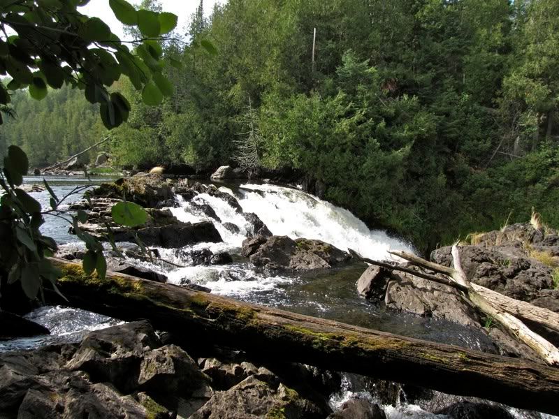
Crashing down -

Splashing onward -

Here's a little video of the falls. I couldn't get the video to embed, but if you click on the thumbnail it will take you to the video on Photobucket. If you like you can then switch to full-screen mode. Don't forget the sound. Then hit the "back" button on your browser when you're done to get back here -

After taking in the falls from various angles, we retraced our steps to our canoe. I was still amazed not to have seen anyone here. Back on the water, we backtracked past the outlet and rapids of the Maligne, to a portage to the Unnamed Pond that is between those very rapids and Silver Falls. The landing for this portage was kind of faint, but a junco flashed its white outer tail feathers to show us the way. Looking back from the landing at the southern tip of Saganagons -

This portage is rocky and apparently not that heavily used. I almost slipped and killed myself but managed to stay upright -

At the other end is a small pocket of flat water downstream from Silver Falls and just above the last rapids into Saganagons. The falls are a ways upstream from here, with powerful rapids tumbling down into this little stretch of still water. There's a campsite in here where we stopped for lunch. We tied off our canoe and looked upstream at the water that had poured over Silver Falls not too long before, perhaps while we were watching -

The last rapids coming downstream above the campsite -

The rocks along the shore here are very ragged. They reminded me of the terrain just below the Great Falls of the Potomac north of Washington. I think this is the result of the ancient action of the falls eroding the super-hard rock. Slowly the falls move upstream as they erode the rocks downstream, leaving this behind -

Abstract -

After lunch we headed to the portage to Lilypad Lake. This carry turned out to be a doozy, the price of our detour to see Silver Falls (which was well worth it). There is a creek meandering up from the Unnamed Pond where we had lunch toward the portage to Lilypad, and you are supposed to paddle up this creek to the portage. The problem was there was almost no water in the creek, so we couldn't paddle through to the beginning of the portage. It took us a while to figure that out, though. At first we thought we were at the actual portage when the creek gave out, though we weren't quite sure which side of the creek the portage was on -

We scouted a bit, and decided we would carry the gear a short distance, then reload the canoe and paddle further up the creek. Here's David getting ready for the first leg of the carry -

The muck swallowed my legs on both trips over that first stretch. Once we had all the gear over to the place we planned to start paddling again, we assessed the situation and decided it was too risky to try to paddle, as we could get stuck in man-eating mud and never get out alive. So we carried the gear over a beaten, soggy path through the grasses up to the end of the creek where the real portage starts. Here David is getting ready for the next leg of the carry. He has the paddles in the pack so he has his hands free to take pictures, because for reasons that are too complicated to explain, the camera was not available during the trip back between loads when picture-taking normally occurs -

Me carrying the canoe through leg-devouring grasses, photographed by David walking behind with two paddles sticking up out of his pack -

Zoom lenses, you have to love them -

Another vid (click on thumbnail, select full screen and sound if desired, hit back on browser to return here when done) -

Weeks later, we arrived at the beginning of the real portage -

It turned out to be a pleasant path through the woods and deposited us in short order at Lilypad Lake -

Out on Lilypad, we paddled along the western shore, where we passed the end of the other portage into the lake from the other southern bay of Saganagons. For those of you taking notes at home, that may be an easier way to get here. Which is why I'm glad we went this way. Lilypad is a nice, very clear lake. It supposedly has a campsite at the narrows, but the site looked pretty austere even by my standards. Paddling in that direction -

The southern arm of Lilypad is very shallow, clear, and delightful. Soon we came to the portage to Jasper Lake. Thankfully, we arrived at the real portage without any mucky grass to fight our way through. The portage starts off over a open rock -

It then continues through the woods, where we found one wet patch, but it was not bad in this dry season. Otherwise it was smooth sailing. Arriving at Jasper Lake -

We had thought about continuing to Ottertrack Lake to camp today, but once we were on Jasper, we decided we would stay on it if we had the lake to ourselves and found a good site. We paddled over to check out the site on the largest island in the lake and decided to stay. The tent and fire area of this site is a climb up to the middle of island, in a somewhat dusty clearing, mostly enclosed by trees, but with a good view to the east -

The takeout for the campsite at the south end of the island had a great spot for a swim, which we really enjoyed after our sunny mucky grassy portaging. The day stayed plenty warm. We waited for shade at the fire ring, then cranked up the stove to make dinner -

I kind of wanted a beer with dinner, but alas, the bar was not serving. I had to console myself with the beauty of the spot -

Ahh -

After dinner we went for a paddle along the southwest shores of the lake. There's another small campsite down by this big landmark tree -

Jasper is ringed by dead trees right at the shoreline. We figured they were killed by a rise in water level at some point in the past (those darn beavers!). I read a report somewhere that described the effect as depressing, but I found it beautiful. The passage of time might have made a difference, because today, at least, the dead trees are clothed in old man's beard and other lichens and glowed a subtle green in the low evening light -

A beaver slapped his tail at us when we paddled into the western bay of the lake. The dead trees stood sentinel in the evening sky -

Back at camp, we rearranged some rocks and logs to build some seating at the viewpoint looking east, where we settled in for our nightly round of Maker's Mark. The dew started falling early, while it was still very warm. It didn't seem that humid, but dew fall like that usually means it won't cool off too much at night, dashing our hopes for cold sleeping weather. But the warmth was nice while we sat on our perch, looking up at the stars, meteors and satellites that filled the night sky.
Once again we got in the tent about 9:00 and read maybe till 10:00. Even after we turned the lights out, the loons of Jasper stayed loudly vocal all night long.
 Donate - BWCA.com