BWCA Entry Point, Route, and Trip Report Blog
April 27 2024
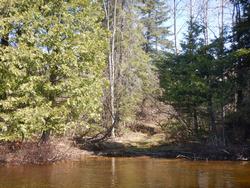
Entry Point 80 - Larch Creek

Number of Permits per Day: 1
Elevation: 1217 feet
Latitude: 48.1270
Longitude: -90.8304
Larch Creek - 80
Ironing out the wrinkles in my soul
Entry Date:
May 13, 2023
Entry Point:
Snake River
Number of Days:
3
Group Size:
1
#84 Snake River is probably the closest BWCA entry point to where I currently live, so the inherent convenience factor played a huge role in choosing this route. I usually loathe to be out anywhere on fishing opener but, I only had a small window of time available, and this happened to be the weekend.
My van is locked, loaded & ready to roll the night before and helps ensure a 0’dark thirty departure. The Tomahawk Road literally runs right out of town so I’m almost instantaneously ‘off the grid’ as I rumble along the still shadowy gravel on my way towards Snake River entry point #84. There are still some small clumps of snow desperately lingering in the ditches along the way as the sun is just beginning to peek over the horizon just before I turn off the Tomahawk Road down the Little Isabella/Snake River spur trail.
It has been another long hard winter with record snowfalls in many areas here in northern Minnesota. The road ahead is littered with remnants of the fallen trees and branches that, thankfully, have been sufficiently cleared to make unfettered thoroughfare possible. At the “T” I take a hard left and the road becomes even more rustic. In fact, I’d venture to guess this is perhaps the least developed drive to any entry point in the Boundary Waters. In a few areas the bottom of my van inadvertently, though unavoidably, becomes a little shinier but, I’m able to meticulously proceed onwards all the way to the parking lot without serious incident or damage. 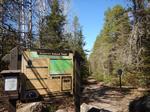
No sooner do I get out of my van to begin unloading than I hear another vehicle approaching. It’s a father & son heading in for a day trip to do some fishing. While they are incredibly friendly and I do enjoy our brief conversation. Not too long after, yet another vehicle pulls in; a day hiker & his dog. While I don't begrudge any of these people for doing what they're doing; still, these remote early morning encounters further confirm why I normally like to avoid being out on fishing opener weekend.

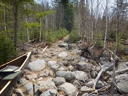
To the business at hand...The path starts out in fine fashion as back in the 1960's it was a road back to an old logging camp. Certainly this has got to be one of the straightest portages I'll ever encounter, at least until reaching the well-constructed bridge just before the site of the old logging camp where the trail then turns down a root & boulder laden hill tracing the course of the aptly named Snake River. Coming back for my second load, the almost imperceptible gradient of the straight stretch back up to the parking lot now generates a deeper breathing cadence. Except, of course, in the very level wet and muddy mid-section. 
I’ve used this entry a few times in the past so, I can tell the water level is still high but not exceedingly so. Lingering patches of foam hint that the water was higher not so very long ago. The upper reaches of this ‘river’ are more creek like as the constricted banks don’t allow much room for maneuverability. Often, I find the best course of action is to just grab some of the overhanging branches and pull myself ahead. Still, I’m making ever steady progress and soon arrive at the first portage.

There is a clearly obvious grassy landing here on the eastern (right side) shore. I cannot see the entirety of the flume, so I crawl out to check things over. The trail is overgrown but easily followed for its 15-20 rod length, save for the abysmal gauntlet of shiny smooth roots throughout. After assessing that the waterway is free of obstruction, I gingerly shuffle back across. It’s a quick uneventful run-down the small rapids where the Black Pearl picks up a few new minor scrapes along the way before quietly gliding off into a now widening waterway. 
The floodplain near the confluence of the Isabella River is soon encountered. Maps show that there is supposed to be at least one other portage around this area but, I don’t see anything that even resembles a need for getting out, so I contentedly paddle on.
Just below where the last rapids of the Isabella River wash out is the father/son duo ’d met earlier as well as another group of fishermen. I’m not here to fish, just curious about the portage and the campsite on the upstream side. For my solo last spring, in through Island River EP #34, I had the over ambitious goal of day tripping to this end of the river. High flood waters & windy conditions conspired to convince me, quite easily, that would not be a prudent strategy.
So, being it’s still quite early, I feel the tug to revisit these ‘old haunts’ and recall the ghosts of trips gone by. The last time I did this portage has forever been emblazoned in the deep recesses of my memory. It’s not that it was/is the most difficult path, it was just a portage where we did not conserve the energy or motivation to undertake it after an exhilarating, though very long, day. We wrongly surmised the camp near the upstream side of this trail would assuredly be open and thus were forced to undergo one last long agonizing portage upon finding it occupied. To this day, I don’t think I’ve ever been so happy to be finished with a portage?!
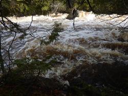
The portage is pretty much as I remembered it. Along it’s steadily climbing course, it runs tantalizingly close to the shores of the river, where the swift crashing & bubbling of the ever-cascading water provides a motivational backdrop to get across so as to go back and see what's making all the noise. Since I am without burden this morning, I soon veer off and bushwhack down to the river’s edge where I am treated to a still very full and root beer hued waterway shrouded by some impressive shoreline cedar trees. It’s early, in both the day & season, so the bugs are not an issue while I linger here relishing the sounds and smells of this much anticipated & overdue re-visitation I’ve been graced with today. 
Working my way back on to the portage trail, I encounter a number of large downed trees across the path. Since I’m just hiking, they don’t present too much of an annoyance but, certainly would if I had been bringing the Black Pearl or my pack across. I note that the landing on the upstream side is precariously close to the top of the rapids before cutting off up the spur trail to the campsite.
This is/was the site we had hoped for so long ago. For the first time I finally get to set my eyes on what we bypassed. It’s a nice elevated site with a few excellent grassy tent pads and is not totally burnt out. There’s a panoramic view back up the river that can be contemplated from an ideal sitting rock just up from the fire grate area. The log seating could use an upgrade (and there are a few serviceable replacements already cut near camp), and another huge drawback is that there is currently a huge widow maker leaning in the near vicinity of the best tent pads. I devote some extra time sitting out on the rock knob looking back upstream, fondly reminiscing about the trip through here so long ago.


I’m not sure where, exactly, cartographers would say the Isabella River ends and Bald Eagle Lake begins but, I surmise it to be shortly after passing by north of the currently occupied campsite #1726. I mention it because it is here that an actual bald eagle regally soars just overhead. Instantly an unexpected tingling sensation runs down my back and I become certain of the significance of this event. Let me be clear, I’ve seen countless bald eagles including more than I can count in canoe country but, I will get to the noteworthiness of this particular siting later.
Traveling up the campsite rich eastern seaboard of Bald Eagle, I check out a few of them along the way. The next one, #1727 (in particular) catches my fancy and it is with some regret I press ever northward as getting at least somewhat off the beaten path is a primary factor in choosing camp. With the current high waters, I can paddle very near the otherwise rocky shorelines. There is an ever so gentle breeze that does little to hinder progress but, since the shores are rimmed with lush cedar trees, the intoxicating aromatic indulgence that it proffers up is truly invigorating.

Soon I turn into the tiny bay where the portage landing for Gull Lake is situated. Normally, this is a troublesome boulder garden but, with the high water, I glide right in with nary a scratch. Although a bit damp, there is a roomy staging area here and I take a moment to gather my wits about me before undertaking this notorious portage.

For me, one of the principal reasons I so enjoy traveling in canoe country is the obvious relation it has with Christian Spirituality by transforming the suffering of deprivation & labor into exultant joy. Let’s face it; most people would NEVER subject themselves and their leisure time to even camping in a tent much less also dragging their food, clothing & shelter across as little as a short easy bug free portage and then exuberantly call it some bizarre version of therapeutic joy. Yet, that’s essentially what anyone who enjoys spending time up here is doing! So, at least in a small way, the transforming of my labors here can help me grow spiritually by preparing & strengthening me for the undoubted struggles that still await me in all other areas on my life.
Of course, all analogies fall short on at least some level and this is a freely chosen endeavor not a random unforeseen event. And, I’m not trying to suggest or trivialize that because I’m doing a tough portage means I (or anyone else) will ‘magically’ be able to adroitly deal with things like an accident, illness or death etc. without plunging into the depths of emotions. But I do believe the type of transformation I detail here certainly promotes spiritual growth and will help to give me a deeper understanding, a sense of fortitude and a better perspective when those type of things do roll around. Most especially when I allow Christ to walk with me through those experiences - small & big.
The trail is initially wet, faint, rocky though easily followed and I soon encounter several nice sized cedars including one substantial upland specimen on the south side of the trail just after the first big climb. These noteworthy cedars aside, much of the portage passes through newly sprouting birch forest where there appears to be no shortage of ruffed grouse. Closer to the creek end there is a neat opening where the trail passes over an immense rock knob before dropping steeply down a rugged path to an undersized, cumbersome landing. There is an impressive nearly sheer granite rise just across the creek.


Yet again I have no trouble as there is sufficient water for enjoyable landing & navigation. The small tamarack trees are just beginning to needle, and I immediately think ahead to how ablaze in color this creek passage will be in October. There is a small beaver dam & hut very near my next portage. And, the resident beaver has carelessly let some of his chewed sticks drift down stream so, I grab a prized specimen for my ‘pokey’ stick once I reach camp. Also, there is a high ridge just across the waterway. On the top sits a large solitary boulder and for some reason I get the uneasy feeling that it’s somehow watching me! Maybe that last portage took more out of me than I realize? :) 
The landing here is a little mushy but otherwise unremarkable. There is a short climb right off the bat and then some very minor undulation along a boulder laden, burnt over trail. Island campsite #1740 can be seen from this bouldery landing and I set course for that potential new home post haste. 
Conventional wisdom has it that this is one of the better sites in this burnt-out area. And I must concur that it is indeed just that; as it does not appear to have been ravaged by the fires of the past decade or so. Still, there is just something lacking for me here today and I decide to push on. On the way to the portage to Pietro Lake I also quickly determine that site #1740 is even quite a bit less appealing. However, the large sheer cliffs looming across the bay behind camp intrigue me so I paddle over for a closer, more thorough inspection.
It’s a reasonably easy trek to the top of this granite escarpment as the fires cleared this area out pretty good. I take a few moments to enjoy the incredible vista across Gull Lake before heading back down to continue my journey.


The landing for the portage into Pietro is exceedingly mushy. And, as I proceed down the trail, I encounter a few more well-defined mud holes which are then followed up by the occasional knobby boulder. The path is very level and I’m shocked to see a couple sizable mounds of snow still holding sway near the boulder infested landing on Pietro.
Pietro Lake has had the great misfortune of having had 2 major wildfires ravage its shores in the past generation. And to be sure, the regeneration of the surrounding forest is still something of a work in progress. I don’t think too many have recently targeted this lake as a destination which kind of inspires me to spend some time here if possible.
As I begin a clockwise circuit around the lake, the site nearest the portage in from Gull soon comes into view. I paddle up and quickly assess this slightly elevated site as worthy of being my new home for the next couple of days. An exquisite flat area with room for at least a couple tents is tucked back in the shaded corner. An emerging stand of jack pine behind camp and the shoreline has a dozen or so up & coming cedar trees which will really fill in this site beautifully in the coming years. There is a very tiny island just out from camp that adds to the scenery and an easily accessible massive rock rise behind camp that provides an overlook of the lake but, with the trees growing this will likely soon be minimized. There is an active beaver lodge in the small back bay and some loons are soon checking me out as well. This site will only get better with time if the trees are left alone and I’m happy to call it home for the next couple of nights.


There isn’t much for firewood in & around camp so, taking full advantage of camping in a recent burn zone, I paddle a very short distance NE up the shoreline and pull out several of the still standing, dried out skeletal remains of several old cedar & spruce trees. Soon, I am putting my recently acquired beaver stick to its intended use as I savor the flickering, ambient glow of a warming fire during a rapidly cooling evening under an elegantly starlit sky.


~Snake River, Isabella River, Bald Eagle Lake, Gull Lake, Pietro Lake
A sunny though cool, crisp morning with only a smattering of wispy clouds in the sky. After a hearty breakfast I load up for my day trip. Conflagration is a word that comes to mind when trying to pithily describe Pietro Lake. There’s clear evidence the forest is coming back but, the number of dead, downed and bleached trees that can be easily contemplated from my vantage point out on the lake is staggering. As I work my way to the Camdre Lake portage I search out the other campsites on the lake. There’s a definite trail where site #1737 is supposed to be but I have my doubts. Walking a short distance into the woods, I soon discover a fire grate but the trees, shrubs & grass are so dense here that I consider this more of an abandoned fire grate than a campsite.

As I close in on the location of the portage, it’s obvious the intensity of the fire must have been at, or near, its peak as it seems even the soil in this area seems to have been burnt. I’m utterly flabbergasted as I paddle past what I presume is a rock cairn; which in fact turns out to be a neat little campsite table. The fire grate is literally a few feet off the lakeshore next to it. (Although, I am here during very high water so presumably some real estate would gain back under normal conditions.) I don’t stop here but, with all the downed timber surrounding this odd couple I cannot fathom where a serviceable tent pad would be.

The landing for the Camdre portage would but all be impossible to spot from any distance out on the lake. It is however within easy eyeshot of the aforementioned camp #1738 - It’s not even obvious once you see the trail but, you need to be close to do have any chance. The re-emerging foliage in this area isn’t sprouting up in thick clusters but rather a tree here a shrub over there etc. Generally speaking, the path is discernible but, I could envision it would currently be easy to wander off without realizing it. I think this affords a unique opportunity to explore off the beaten path (if time allows?) without having to bushwhack as you can freely move about unhindered by tangles of brush & branches – in my experience a rare situation in BWCA. The portage itself is basically an up & over. I won’t say the hill on this portage is too severe but, it is enough to stop me at about mid trail and pull off my wool over-shirt. There is a nice green grassy landing on the Camdre end.
 Camdre openly reveals near complete devastation by the fires as well and I just make a beeline to the portage into Clearwater Lake. This landing is near a beaver hut and is another mushy one. This trail surmounts another pretty good hill but, it appears I’m traveling in the right direction so as to avoid the long climb out of Clearwater on a sometimes-wet path. For the time being; there are somewhat decent overlooks of each lake at various points along the way and the Clearwater landing affords a beautiful view of that body of water and the small islands just out from shore. The portages in this loop of lakes are challenging by BWCA standards but, they’re nothing wildly crazy. However, with all due respect to the Black Pearl, I am really beginning to feel the extra burden of the drop seat and muse the possibility of shedding several pounds of unnecessary weight and perhaps one day traveling with a true solo canoe. The spirit is indeed willing but the flesh is weak. It’s a sobering thought that it appears father time may be catching up to me?

Even though much of it has been burned over, Clearwater still exudes a special beauty. Perhaps just coming in from 2 lakes that absolutely got leveled help to make it seem to shine all the brighter? I also think it gets overlooked; because it is sandwiched a relatively short distance in between 2 exceedingly poplar entry points (Lake One #30 & Little Gabbro #33), one may tend to surmise this area is normally densely populated by mere default traffic funneling in. However, in addition to the burn, the long difficult portages in/out help give this lake a certain added mystique and a very strong likelihood for solitude. There’s now a bit of a breeze blowing across the water but, it does little to hinder my progress as I paddle to the NE corner of the lake to begin my search for the portage into Judd Lake.
Here on Clearwater Lake, it appears there will be something of a sandy beach (under normal water levels) where straight away I happen upon the landing for the Judd Lake portage, which is right where the maps say it is in the extreme NE corner of the lake.
There’s a diminutive creek to cross near the lakeshore and then a big climb up out of Clearwater – which affords a marginal overlook when gazing back. The exceedingly brushy trail rollicks over bare rock knobs, mud holes, ups, downs, twists, turns etc. There's a nice overlook of Judd Lake at that end but it's kind of deceptive because I think I’m almost there and then the trail keeps switching back and takes longer than I think it should to reach the lakeshore. Basically, it has a little bit of everything that reminds me of a shorter version of the Paulson to Sea Gull portage. Currently, I think the biggest obstacle will be dealing with the continual scratching of branches if bringing a canoe across. For those that might be interested? I shot a video of the entire trail starting at Judd Lake – it's about 20 minutes long.
Back on the crystal-clear waters of the fittingly named Clearwater Lake, I work my way westward along the northern shoreline as the unseasonably warm temperature continues to climb. The 3rd site west of the Judd portage is, in my opinion, the premier site located within the quintet of lakes located NE of Bald Eagle Lake. It is elevated with good views & tent pads and a smooth sitting rock with a nearby sandy area to the west for swimming. There're even some old artifacts propped up as a wind break around the fire grate.


It looks awfully ‘moosey’ as I near the origins of the Pagami Creek fire but, none show themselves here today. The portage into Turtle seems a lot less arduous than others in this immediate vicinity as I don’t notice as much of a gradient along this long path. Still the high midday sun relentlessly beating down uninhibited on my black canoe helmet dishes out a different kind of punishment. Fortunately, there is a wide canopied green cedar tree at the Turtle Lake landing with which to prop myself against and cool off in the luxuriant shade its currently bestowing on this weary traveler. I do battle with a few bugs but, providentially they are not yet at the peak of their powers. 
After refreshing myself, I undertake getting out past this landing. It appears the boardwalk is in complete disrepair as I note several planks floating out on the water. Not sure what this will mean once the water level recedes? Endowed with countless islands of various sizes peppered across its waters, Turtle Lake is a site to behold and is the most scenic of the lakes I’ve visited today. Unfortunately, the campsites on the lake don’t offer much in the way of amenities as the Island site appears abandoned and the 2 mid-lake camps are barely adequate for smaller groups. As should be expected, I do happen upon a couple of turtles sunning themselves, and then spot the first person I’ve seen since leaving Bald Eagle Lake the other day; a solo traveler out fishing who appears to be staying at the campsite just off the portage out.


This end of the portage has a neat huge overhanging rock escarpment just off the trail where there is also something of a small cave. It also boasts a large flat sitting rock which would serve well for staging packs too. There’s a steep climb out of Turtle but it’s noticeably shorter than the extensive descent down to Bald Eagle so, I feel I got the better end of the bargain traveling in this direction for this portage as well. Having now completed all the portages in this loop, I feel this one is assuredly the most grueling. (Not factoring in the Judd trail.)

Coming out of the burn zone makes the vibrant green backdrop of Bald Eagle Lake appear to be The Garden of Eden. Speaking of which, I now return to the story of the bald eagle fly by from yesterday. The reason it gave me chills is because part of my motivation for doing this trip was to pay tribute to a departed fellow paddler known as “dicecupmaker” on bwca.com.
A bit about who he was: Anyone who had been a member there prior to his passing certainly knew of Mitch; as I don’t believe any member bled the orange & black of bwca.com as fervently. He graciously donated homemade leather can coolers to the monthly photo winners and made custom leather work for several others too. Not to mention the novel bearpaw awards to those achieving that status. He was most certainly proud of his boys & I had the good fortune to meet his friend CarolynS @ last falls wingnight and learn more about him. One of his sayings was that canoe country “irons out the wrinkles in his soul” (which ties in quite nicely with the spiritual aspects of this trip already mentioned) and that the iconic bald eagle was his favorite symbol of this area.
I don’t believe Mitch ever actually paddled Bald Eagle Lake but, since the bald eagle meant so much to him; apparently some of his ashes were spread in the vicinity of the island near the channel into Gabbro Lake so, seeing that eagle where & when I did seem like way more than just a coincidence. I dutifully paddle over to a convenient landing where it almost seems like this may have been a campsite at one time. I locate a shaded area with a large tree for a back rest and pull out my Saint John Paul II rosary ring. The thought that is put on my heart while praying is that I don’t think any of us fully realize the overflow of love we all unwittingly generate in the world. Not by necessarily doing anything particularly grandiose but, just by simply being ourselves. May God grant eternal rest and allow his perpetual light shine upon you Mitch! 


Afterwards, I retrace my route from yesterday back to camp, noting the snow is still precariously hanging on by Pietro Lake. Ironically, shortly after returning to camp I feel something on my hand after sitting down. It’s a mosquito!!! It’s only one and I don’t have further problems with any others, but it still speaks to the hardiness of these perpetual pests with snow literally still on the ground just a few hundred yards away. It’s a noticeably warmer evening tonight as I am also appreciative of another glittering star filled blanket covering the sky.


~Pietro Lake, Camdre Lake, Clearwater Lake, Turtle Lake, Bald Eagle Lake, Gull Lake

A couple of trumpeter swans greet me at the landing back into Gull Lake this morning. Since the water is still above normal levels I decide to see if I can skip the portage into the creek and just paddle through. High cliffs rise off the shorelines here and I can also see the last beaver dam just before the portage landing. It's pretty much free sailing until just before the dam I need to half hop out and give the Black Pearl one little push to get through. Easy peazey!

Of course, I’ve had a chance to get my portage legs back in shape and my pack is noticeably lighter but, the portage back to Bald Eagle Lake certainly seem easier when traveling in this direction even with the ruffed grouse still on high alert. There is some ‘walleye chop’ out on the lake that is fortuitously mostly blowing in the direction I need to go. Providentially the occupied campsites from my entry day are now vacant and & I briefly stop to check them out on my paddle back to the entry point. #1726 at the end of the Isabella River/beginning of Bald Eagle Lake; was where my brother & I ended up after completing the infamous portage so, it was neat to reminisce one last time. Ironically, I think the site is more accommodating than I remember!


The floodplain at the confluence makes it a little confusing to find the true channel back into the Snake River but, I don’t have any serious delay. I need to use the one and only short portage back up stream on my return trip. And, In short order I’m back at the entry point landing.
As I’m bringing my first load back, I run across a friendly group of 4 just entering. We all pass by each other again as I head back for my last load and we stop and chat as I give them some current info etc. Soon after we part ways, curiously there is another loaded down traveler headed in my direction and then another! They did not come from the river landing I was at so I ask them where they are coming from. Apparently, there is an extension just past the old logging camp that runs all the way past where the 2nd portage should be. They tell me they heard this was put in illegally by someone but, it’s kind of a what's done is done scenario so.... Under the current conditions I don’t think this would save any time/sweat equity but, I suppose later in the summer with lower water it might? Anyways we have an enjoyable further conversation before finally parting ways.
At the junction of Highway 1 and the Tomahawk Road, in remembrance of this trip, I take a quick shot of the bottle cooler Mitch made for me. After that, I head to The Boathouse for a burger & beer.

This was a short though challenging trip that, once I pushed past Bald Eagle Lake, provided almost complete solitude even on an unofficial state holiday weekend. I don't think the Snake River sees a lot of usage and I'm sure it would be a tougher paddle come summer - probably why that trail extension was cut. Still it's a viable alternative route to this poplar area and I looked at the narrow waterway as adding to the adventure. I hope I was able to show Mitch a good trip as I carried his memory with me throughout my travels. As mentioned, seeing that bald eagle when & where I did clued me in that Mitch was indeed watching over me. Essentially this was a good warmup for the paddling season ahead as I was able to add the first 2023 lake/river names to the list in the Black Pearl. And, more importantly, a spiritually rich adventure.


~Pietro Lake, Gull Lake, Bald Eagle Lake, Isabella River, Snake River