BWCA Entry Point, Route, and Trip Report Blog
April 27 2024
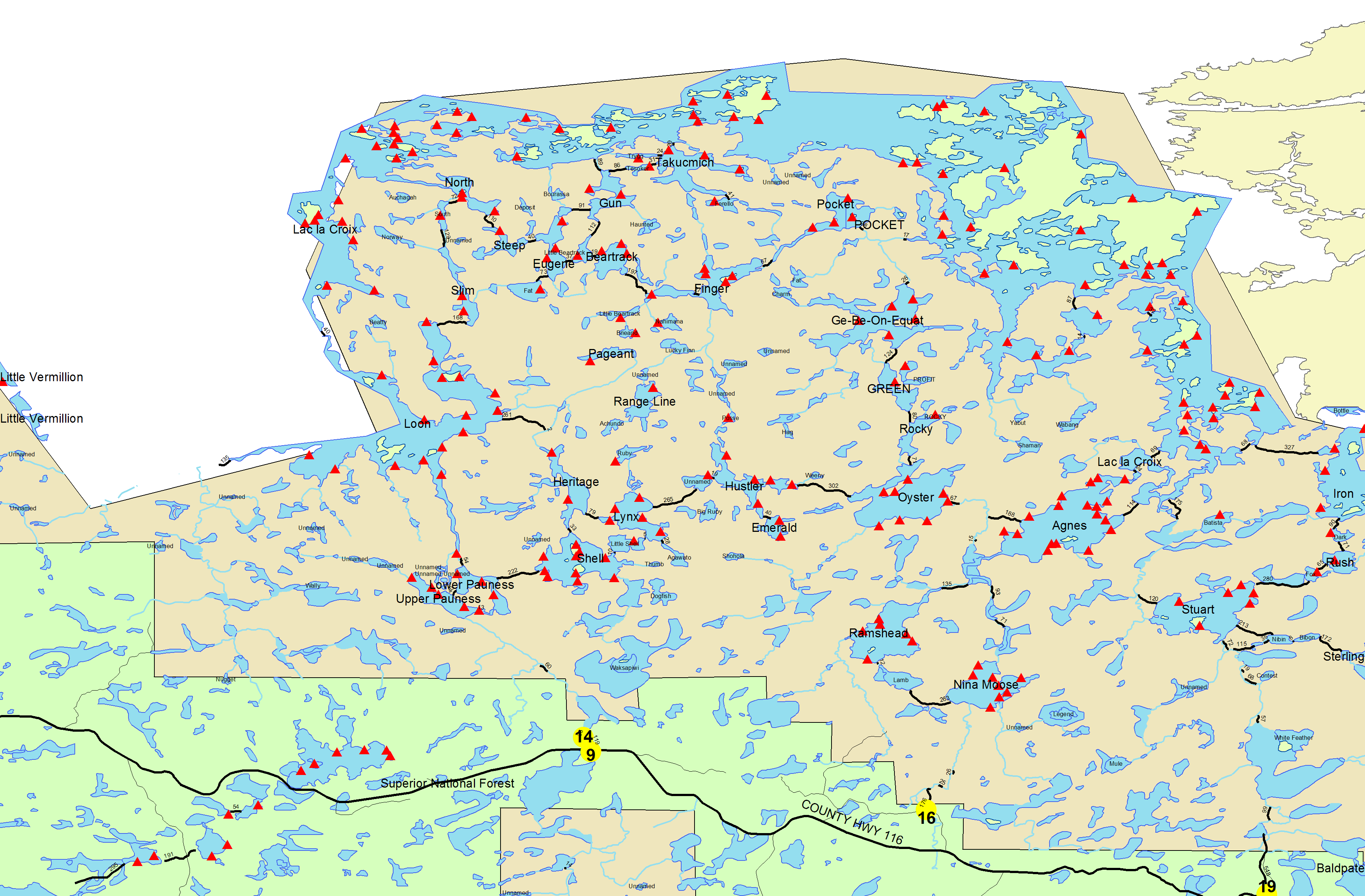
Entry Point 14 - Little Indian Sioux River North
Number of Permits per Day: 6
Elevation: 1364 feet
Latitude: 48.1466
Longitude: -92.2103
Shell, Lynx, Hustler, Oyster to EP 16
Entry Date:
July 26, 2017
Entry Point:
Little Indian Sioux River (north)
Exit Point:
Moose/Portage River (north) (16)
Number of Days:
7
Group Size:
4
The 216-rod portage into Shell was flooded for 20-30 yards near its midpoint. We reloaded canoes and paddled it, but also saw a young couple portage straight through the waist-deep water. I saw a rose-breasted grosbeak watching us from a birch. A challenge launching the canoes on a very muddy shore. The sites on Con Island (which looked nice) were taken, so we checked out the smaller island before deciding on the southernmost site. Strong, steady northern wind. Many tent pads available. The water is cloudy and almost as red as Pine Lake. The lake bottom here is shallow and muddy. No action casting from the shore, nor from the canoe. The evening mosquito swarm was vast and fierce. They settled down ever so slightly in the dark of night. We watched the red crescent moon set behind the trees, then went to bed.
Casting from shore I only got a hit from one of the larger rock bass. The latrine is full of water and feces to within 6” of the brim. Many people have used alternate spots and have done a poor job of cleaning up after themselves. One of our group found a second, emptier, latrine. Muskrat scat on the shore (fresh and aged), and we saw what we thought was an otter looking at us from the water. Bear scat in the campsite. Red pine, jack pine, white pine, spruce, fir.
Easy 15-rod portage to Little Shell. Crossed paths with a portaging group. Another group was relaxing on the shore of Little Shell, and the one campsite was occupied. High water, so we floated straight into Lynx, skipping the 4-rod portage. The two southern sites were taken. The western site looked nice but perhaps too near some swampy waters (still scarred by the mosquitos of Shell). The NW site had a very steep ascent into camp. Paddling across the lake to the NE site we saw lightning strike three times, so the search was terminated there. We quickly set up tents, but the storm stayed to the north of us, blowing east, without a drop of rain. The water is quite clear, and gets deep fast off the shore of our campsite. Some rocky structures underwater. Caught a small eater walleye from the shore of camp, but mostly snags and tiny rock bass. Not too much luck fishing from the canoes, but we got a big smallmouth to complete the dinner. The mosquito swarm never appeared in full force. A protective cloud of dragonflies swarmed the shore, eating the mosquitos before they could reach our camp.
The campsite is mostly red pine with some jack pine and cedar. Birch, white pine, and spruce also around. Red squirrels very active. Many blueberries, a couple serviceberries, and sarsaparilla. Flies are a menace at this site, making up for the reduced number of mosquitos. Saw a large turtle head come up for a breath. Many small fish splashing at the surface.
Short paddle to the pretty serious 280-rod portage to Ruby Lake. Well-maintained trail. Muddy spots were shallow, and no bugs on the trail until emerging at Ruby Lake. Brutal ascent halfway through the trail. Ruby is a beautiful small lake. 70+ feet deep in the middle, exceptionally clear water, and many bass. There's a single campsite that I would consider for a future trip. Fished a bit and made the 10-rod portage to Hustler. The northern campsite seemed too small and close to shore (the fire grate right at the water). The two north shore campsites were occupied but looked good. We chose the southern site, which is small but nice. Isolated from the other camps as well as the route between the two portages. Beautiful water for a much-needed swim after the hard portage. Darker water than Lynx. The site is on a rock face that drops deep quickly. Blueberries and jack pines. Red oak and maple saplings. White pine are abundant around this lake. Flies and mosquitos. A lone carpenter ant.
Fished the south arm by canoe. Mostly smallmouth bass, and mostly too small to keep, but one of us caught a nice pike (returned to the lake). Plenty of flies during the day, and plenty of mosquitos at night. The mosquitos are brutal. Frogs and toads overrun the campsite once the sun goes down. A nice, remote lake, so we took a layover day here.
Fishing the island in the middle of the lake we caught a few nice smallies for lunch. Abundant blueberries on the rocky shores if you make a special trip by canoe. A group of five loons put on a show in front of our campsite in the evening. A lone herring gull had a territorial dispute with them, flew away, and circled back to drop a vindictive shit. Heard perhaps a beaver plop into the water at nightfall. Brush too thick to hike any farther than the latrine.
Short paddle to the portage over to Oyster. It was longer than the portage in, but easier. Flatter, and well worn. Lowland near the Oyster side was flooded, but there were logs laid out a few inches below the water, and I walked right through. Chose the campsite at the narrowest point of the peninsula. Very large and open with a more exposed rock and grass area as well as a woodsy area covered by small red pines. Lots of cedar, also spruce. Easy access to both sides of the peninsula allows more variety for swimming, fishing, and viewing. Water on both sides is shallow. Mud floor with rocks closer to shore. Large rocks on the east side. Cold water nearer the surface on the shallow east side. Straight out it gets down to 130 feet. Mosquitos were especially bad at night. Listened to barred owls asking “who cooks for you?” from the tent.
Another layover day. Trolled the lake for trout, but had no luck, and a strong wind tired us out. Portaged across camp (another advantage of the site) to the west side for more wind break and fished the shore. Nobody got a hit, but I got a sunburn. Swimming I found a deep-diving rapala and an old glass soap bottle on the bottom. Mosquitos terrible again on the second night.
The Oyster River was passable in the high water (members of our party had crawled through it on a previous trip), and it was a nice change of pace from the lakes. Many dragonflies, flies, and other insects. Ditch weed growing at a portage. Didn't notice Ramshead Creek as we passed it. I guess it was more overgrown than we expected. At the first Nina Moose River portage we encountered the first of many groups along today's route. The next, 70-rod, portage was along some nice rapids, and it looked like it might have a good swimming hole for a day with more free time. The day was hot, but we were trying to make time. Cut across Nina Moose Lake to the Moose River. A different character than the grassy Oyster River. Saw a couple deer. Velvety antlers on the buck. Just as we thought we were at the entry point we discovered there was an extra short portage not indicated on the map. The 160-rod portage out was not bad.~Upper Pauness Lake, Lower Pauness Lake, Shell Lake, Little Shell Lake, Lynx Lake, Ruby Lake, Hustler Lake, Oyster Lake, Nina Moose Lake