BWCA Entry Point, Route, and Trip Report Blog
April 27 2024
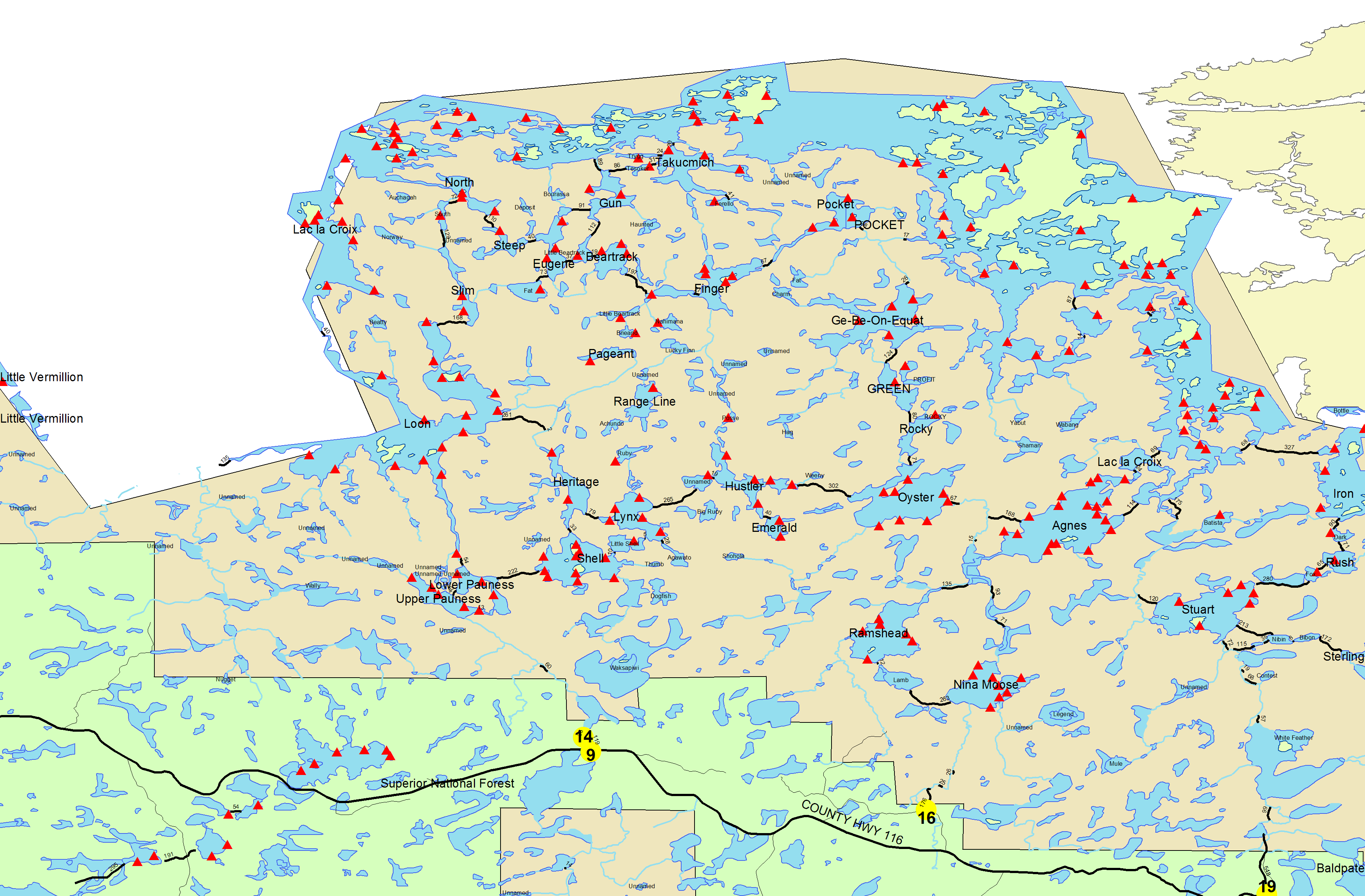
Entry Point 14 - Little Indian Sioux River North
Number of Permits per Day: 6
Elevation: 1364 feet
Latitude: 48.1466
Longitude: -92.2103
EP 14 to EP 16 Northern Loop
Entry Date:
June 15, 2013
Entry Point:
Little Indian Sioux River (north)
Exit Point:
Moose/Portage River (north) (16)
Number of Days:
6
Group Size:
6
After waiting through a Saturday morning rush at Briton’s Café for a big breakfast, we headed out the Echo Trail to EP #14, Little Indian Sioux River. The drive took at least an hour. As soon as getting everything unloaded from the truck and trailer, two members took the truck and trailer to EP #16, Moose/Portage River (about 9 miles away), and parked them there because that would be our exit point in six days. The car shuttle crew returned to EP 14, hiked down the trail to the river, and joined the rest of the group. We hit the water about noon, and arrived at our campsite at East Loon Bay (#24) about 5:00 p.m. We had a little problem on the way finding the 40 rod portage from Upper Pauness to Lower Pauness, and had to backtrack after missing it, but other than that, no problems. We covered about 12 miles. Campsite #24 on East Loon Bay was a nice one with tall pine trees and nicely cushioned tent pads.
We got off at 8:00 a.m. and warmed up with the 168 rod difficult portage from Little Loon to Slim. Once into Slim Lake, we easily found the beginning point of the Slim to Fat portage. We had decided to just carry packs the first trip in case we ended up abandoning our efforts. We started off on the trail (yes, there is a trail) and found the early split to the right up a hill. About one-fourth of the way from Slim to Fat, the trail became obliterated by a large area of downed trees and we got off of the trail. We bushwacked through the woods for about 20 minutes and finally ran into the trail again and made it to Fat Lake with just the normal issues of downed trees in the trail. There were no big elevation changes and in most places the trail was plain to see, albeit not wide or maintained. At some points there was not sufficient clearance in the trees, so you had to drag the canoes through on the ground. I actually did see some saw-cut trees along the trail near the Fat end, so somebody has done some maintenance on it. The animals have used the trail a lot as there were many species’ scat along the way. Our measurement of the portage was around 300 rods, but that included some extra distance due to getting off the trail. On the deadhead trip we were able to mark the way better so we would not get lost the second trip. On the second trip, my son and I each carried one of the canoes and two persons carried the third. We all had our difficulties. My son and I both got off the trail at different points because we could not see where we were going, with the canoes over our heads obstructing our vision. We both had to backtrack and drag the canoes some. We thankfully made it to the Fat side and collapsed for some rest and water. A big rain shower came for about an hour and we ate lunch under a canoe at the portage trailhead. We did three smaller portages and made it to a very nice campsite (#93) on the north side of Bear Track Lake by 5 p.m. We only covered nine miles that day, but did lots of portaging.
We had a good day of paddling into Lac La Croix via Pocket Lake and River. We lunched at campsite #146 immediately east of the Pocket mouth. At lunch, we discussed the course we intended to take toward Fish Stake Narrows. On the way toward Fish Stake Narrows, the trailing canoes went off course before the leading canoe knew it, and we were separated. The leading canoe stayed put in the middle of the lake and waited about 30 minutes and eventually the trailing canoes came along, having realized the error of their ways. The rest of the way through Fish Stake Narrows we stayed together. The wind was practically non-existent on LLC that afternoon, so the paddling was easy. We stopped by the pictographs on Coleman Island on way to our afternoon campsite (#171). I do not recommend that campsite. It had a huge sloped flat boulder going down from the fire grate to the lake, which got very slippery when wet. The tent pads were not that great, either. We covered 14 miles that day.
We started the day with a most enjoyable excursion to Warrior Hill. We spent about an hour and a half on the Hill enjoying the view. We had no Canadian permits, as I imagine most visitors there do not. You can debate the wisdom of that, but that is for another forum. After the Warrior Hill diversion, we headed south through Boulder Bay. We took the snaky river passage to avoid a 65 rod portage which I do not think saved any time in the long run. We stopped for lunch in Lake Agnes just after the 24 rod portage, and then pushed on to Nina Moose Lake where we camped at a beautiful spot (#1817). We spent two nights there as we had built a layover day into our schedule. We covered 15 miles on the day
We slept in a little and enjoyed our scheduled day of “rest”. However, five of us in two canoes decided to try a “pleasure” excursion down Portage River and take the east fork to Legend Lake. We made it as far as the unnamed smaller lake west of Legend Lake, which was no small feat in itself. After a big river blockage that require dragging over 7 or 8 large trees, the river became smaller and winding through marshy areas. Almost every bend of the stream required getting out and stepping in the muck to get the canoes through. We could tell we were getting close to the first, unnamed lake, and we just hiked the last 300 feet through the muck and marsh. It was an underwhelming, desolate, muddy pond, half-full of large trees cut down by beavers. Although we brought lunch that was no fitting place to eat it so we took it back to camp with us. Anybody who has made it to Legend Lake from Nina Moose deserves a lot of credit. Our unsuccessful morning excursion was about three miles of paddling and a lot of muck walking. For an afternoon excursion that day, four members explored and climbed the high rock on the west side of Nina Moose Lake, elevation around 1400 feet above sea level. It provided a very nice view of the lake and rivers leading into it. Excursion distance: two miles. It was sunny and almost 80 degrees this day and ideal for napping on the big lakeside rock in front of the campsite. One of the tent sites had some levelness issues but we turned the tent a different direction and that fixed the problem for the second night there. The second night, it rained for 12 hours but we were prepared for it and had everything not in a dry bag under tarps. One of the tarp stakes gave way in the night because of soft soil and had to be corrected by the earliest risers. The rain let up about 6 a.m., so we could get up, eat, and packed to leave.
The last day’s journey was only about five miles and three or four short portages. Some might have been done walking the canoes over the obstructions, or even paddling entirely. The worst portage was a very short unmarked portage about 15 or 20 rods that was 80% full of mud. That would definitely be one to avoid if you can because five out of six in our group slipped and fell in the mud on the trail or lost a shoe in the mud. That little portage had the worst footing of any of the previous 20 or 21 portages on our six day trip. Not a good way to go out on your last day. The last portage out is 176 rods but an easy trail. The traffic heading out on the water that day was very heavy. It seemed like more than six groups entering EP 16 that day, or they all entered within an hour of each other, because the river was already full of groups heading down stream and the portage was teeming with young people who seemed ill-prepared for the adventures awaiting them. When I heard the next five days were going to be rainy, I had even more sympathy for them and especially their leaders. They were already struggling mightily on the portage to the river. [paragraph break]We had the best weather and paddling conditions of any BWCA trip I have done. The highs were in the 60s or 70s every day and lows around 50. It rained a little one afternoon and a lot one night but other than that, no complaints whatsoever. Likewise, I have no complaints about the bugs. As we were entering on Day 1, some people exiting were complaining about the terrible mosquitoes and black flies. We had very few problems with either, but we took a lot of precautions such as Permethrin treatment of clothing, spraying exposed skin with 98% DEET, spraying clothing with a lower percentage DEET, wearing hats and head nets, long sleeve shirts, and keeping pants tucked in socks. We also kept a fire burning most of the time at our campsites.