Boundary Waters Trip Reports, Blog, BWCA, BWCAW, Quetico Park

BWCA Entry Point, Route, and Trip Report Blog

March 19 2024

Entry Point 23 - Mudro Lake

Mudro Lake entry point allows overnight paddle only. This entry point is supported by Kawishiwi Ranger Station near the city of Ely, MN. The distance from ranger station to entry point is 19 miles. Three accesses into Mudro Lake involve portages ranging from 20–185 rods.Easiest access is from private la nd with parking fee.

Number of Permits per Day: 5
Elevation: 1166 feet
Latitude: 48.0356
Longitude: -91.8301
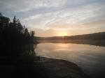
On the Water- Monday July 20th-
On the water late considering how far we need to go today. Up the Horse river to the falls by 6pm. Started raining and NO campsites available. Mudrow-Alruss-Tin can Mike-Horse Lake-Horse River-Basswood. 13 miles by water. (not counting portages)

Tuesday July 21st-
Rain all night, all morning and all day. Went north by petroglyphs, table rock and the the Crocked Lake Narrows across Thursday bay to campsite. Basswood-Crooked Lake-Wednesday Bay-Thursday Bay. 11 miles in the rain.

Wednesday July 22nd-
Up early and calm winds to take advantage of, considering the big water we have to cross. Found beaver dam to lift over and did a portage from hell between Pandos lake and Chippewa Lake. VERY steep and slippery after rain. Many mud holes. Then the mile portage after Wagosh Lake to Gun Lake. Never saw another soul in a canoe or campsite the entire day! Thursday bay-Friday Bay-Pandos Lake-Chippewa Lake-Wagosh lake-Gun Lake. 11 miles by water.

Thursday July 23rd-
Finally had a dry night. got everything dry!!! A few portages today to Fourtown Lake campsite. Easy day by comparison. Gun Lake-Fairy Lake-Boot Lake-Fourtown Lake. 6 miles. Put the long miles at the first of the week for a buffer for contingencies!

Friday July 24th-
Last day. Stormed last night bad. A few portages today with one bad one between Fourtown Lake and Mudrow lake. To entry point by 1pm. Ready for a hot shower! 4 miles

Total-
45 miles by water
13 miles by portage (3 trips each)
58 miles total.

A trip of many firsts.

by georgiaphisherman
Trip Report

Entry Date: May 28, 2011
Entry Point: Mudro Lake
Exit Point: Moose/Portage River (north) (16)
Number of Days: 5
Group Size: 1

Trip Introduction:
The long awaited trip to the Boundary Waters was finally upon me. All of the planning and dreaming was finally here. While driving from Georgia to Ely, I had many thoughts running through my head. What am I going to see/catch/experience? What unexpected challenges would I encounter? Bugs? Weather? Am I crazy for going solo on my first trip to the BW? The original plans for the trip included 3 other guys, and one guy who was questionable. A divorce was the cause for the first guy to cancel, then a job change claimed the next, a baby claimed the next, and the last guy (a week prior) had a flare up with a recurring illness. In the end, it was just myself. My biggest concern wasn’t going solo, but how was I going to convince my wife that I should do this alone? When I first started planning this trip, my wife said to me “As long as you have someone to go with you…” Well now I had a week to convince her! I decided my best shot was to buy a PLB, which would be useful for me on the trip, as well as a good bargaining chip. After many discussions, she finally relented and the trip was on!!! I drove a straight 24 hours to Ely from Atlanta. The combination of energy drinks and adrenaline fueled my drive. As I approached Ely, I got a glimpse of a lake from the highway,and all of my trepidation about going solo disappeared. What a beautiful place! Next, I contacted Mark at Jordan’s Outfitters to let him know I was in town. I met up with Mark at his place, and we chatted about my plans, went over maps, fishing spots, best campsites, etc… Everything was set for my morning departure.

Day 1 of 5


Saturday, May 28, 2011 Before entering Mudro Lake, there is a nice small meandering creek, which was perfect for me to get accustomed to my rented Q16 Solo canoe. This canoe was exactly what I wanted in a canoe for my first trip to the BW. Yeah it was a beast in the wind, not incredibly efficient, but was very stable and fast enough. Leaving Mudro, I entered Sandpit, then Tin Can Mike, on my way to the Horse River. While on the Horse River, a thunderstorm passed over. This was interesting because I had to get off of the water in the middle of the Horse. Luckily, the storm passed after about thirty minutes. I have to admit, sitting in the woods with a thunderstorm directly overhead is definitely unnerving. After gathering my gear, I set out to find an open campsite. I found an open campsite on Horse Lake, just across from Lower Basswood Falls. On a side note, I would definitely recommend this campsite for a great vantage point for watching the sun come up in the morning. After setting up camp, taking some photos of a rainbow, and eating, I started to fish. My goal for this trip was to take a route that would enable me to get a good sample of the BW, and to catch a walleye, smallmouth, and a northern (the BW hat trick). Well, after fishing for 15 or so minutes I caught a small Northern. This was my first Northern. I fished for a little longer before hitting the hay. So far, the Boundary Waters is everything I hope it would be: boundless beauty, awesome fishing, and a paddler’s paradise.

Day 1 Summary: Mudro-Sandpit-Tin Can Mike-Horse River-Horse Lake I put in around 9:00 a.m. and was at camp around 5:00. There were a few points along the Horse River where I had to portage around some rock gardens that were exposed, due to low water. If I were in my own canoe I would have paddled through the rocks, but I wanted to baby the Kevlar canoe.


Day 2 of 5


Sunday, May 29, 2011 I awoke to an awesome sunrise. This place embodies serenity. My goal was to get an early start, before any winds picked up. Well the winds were never a problem. Sunday turned out to be a picture perfect day. Blue bird skies, no wind, and beautiful scenery. My day began by portaging around Lower Basswood Falls. Next, the pictos on Crooked Lake. Seeing the pictos made me appreciate not only the history of this place, but also how valuable wilderness areas are. I can't help but think that I was seeing the BW in a similar, unaltered condition as the person who put those pictos on that rock bluff...truly awesome. The rest of the day was spent traveling along the US/Canada border. I was thankful for the good weather, for I had to cross some big bays. Had it been windy I would have opted to stay close to the bank, which would have taken a lot more time. I saw a lot of ducks today, mostly loons and mergansers. I caught my first smallmouth ever. Somehow I have never caught a smallmouth. Fishing back home, I usually catch largemouth, spotted bass, crappie, and trout, but never have I caught a smallie, so another first for me on this trip. I am blown away with this place...this place harbors unbelievable beauty.

Day 2 Summary: Horse Lake-Crooked Lake

Broke camp around 6:00 and set up camp in Sunday Bay. How appropriate to camp in Sunday Bay on Sunday. There is no place I would have rather been then right where I was.


Day 3 of 5


Monday, May 30, 2011 The fair weather was nice while it lasted, but for the rest of the trip I had some rough weather, primarily strong winds. A storm system moved in and brought cold air and WIND. I got an early start, but before I knew it I was paddling in some very rough water. White caps everywhere, big swells, and strong winds, but my canoe performed nicely. I did struggle to keep the canoe on track, but the Q16 was as stable as a tandem (which it is, minus one seat). Even with the strong winds, I still managed to get to Iron Lake, portaging around Curtain Falls. I hoped to camp on Iron, but I was unable to find a campsite. No one was breaking camp because the weather was so terrible. Here I was wet, cold, and ready to get off of the water, but I had to continue on.

Mark told me to avoid the 320 rod portage from Iron to Boulder Bay. He advised me to take to Bottle Portage instead. However, because the weather was so terrible, I had no choice but to take the longer portage. This trail was lightly traveled, by humans at least. I saw fresh wolf, moose, and bear tracks on this trail. The trail was a little sloppy, but relatively flat. I found the first open campsite in Boulder Bay, which was a five-star site. I set-up camp, ate, and caught some smallies and walleye from the bank. My only complaint so far was how dirty the campsite was. There were orange peels, sunflower seed shells, and other trash everywhere. After cleaning up camp, I explored around the area for a bit, and hit the hay.

Day 3 Summary: Crooked-Iron-LLC

Regardless of the wind, I was able to cover a lot of water. One disadvantage to getting an early start is that you can leave a nice campsite and then get stuck in some nasty weather with no where to go. I realize that I could have just setup camp in an undesignated area, but there were enough islands on Iron that provided protection, thus allowing me to avoid the open water on my way to Boulder Bay.


Day 4 of 5


Tuesday, May 31, 2011 I was hopeful that when I got up this morning that the storm would have passed through. Unfortunately, the storm was here to stay for a little longer. After being stuck out in the nasty weather the day before, I decided to hang around camp for a while. I looked over the map, and decided that the prevailing winds were coming out of the west, and my route provide plenty of protection from the winds. Around 1 p.m. I was antsy to get out and keep making progress. I left Boulder Bay and headed for Lake Agnes. When I got to Agnes, the winds had changed direction completely, and they were coming straight across Agnes. Agnes look like an ocean. The winds were so strong that I could not paddle forward. I had to get off the water, so I found a clearing and hung out on that clearing all day, all the meantime I kept kicking myself for leaving a five-star campsite. Next time I'm here, I will definitely slow down. At points the wind was so strong that it lifted the canoe off the ground and blew it a few feet into some shrubs. This was a serious storm. Being windbound, I had no choice but to camp in an nondesignated area.

Day 4 Summary: LLC-Agnes

Note to self: don't leave a premium campsite when the wind is relentlessly howling.


Day 5 of 5


Wednesday, June 01, 2011 PLEASE have let this storm passed was my first thought when I woke up. Well, I was not so lucky. However, instead of the wind blowing steadily with no breaks, there were small 2-3 minute breaks, which enabled me to leave the undesignate area, and push forward. All I have to say is Agnes seemed like it was a hundred miles long, but I finally reached the mouth of the Nina Moose River. Hoping that the river would be protected from the winds, I entered with no such luck. At the mouth of the Nina Moose, the wind were so strong I was being blown all over the place, but I kept trudging on. Finally, I got deep enough into the river to get some protection from the wind. I entered Nina Moose Lake, where the winds were tame. I saw some folks who had just arive and couldn't believe how strong the winds were on Nina Moose. I couldn't help but think that they had no idea what it was like yesterday. Entering Moose River, I was getting close to the trip coming to a close. After several small portages, I was back to my truck.

Day 5 Summary: Agnes to EP 16. Trip time 6 hours, but with a strong wind.

Trip Summary: This trip was a trip of many firsts. First trip to the BWCA. First solo trip. First time canoe tripping. First Northern Pike. First Smallmouth. I absolutely loved this place. Although I experienced many firsts on this trip, I know that it will not be the last.

After getting back to civilization, I checked the Weather Channel's history and the winds were in the 40 mph range, with gusts in the high 50s. Not exactly paddlecraft weather, but none the less a PERFECT FIRST TRIP.


Routes
Trip Reports
a
.
Routes
Trip Reports
Routes
Trip Reports
Routes
Trip Reports
.
Routes
Trip Reports
Routes
Trip Reports
x
Routes
Trip Reports
fd
hgc
Routes
Trip Reports
Routes
Trip Reports
Routes
Trip Reports
Routes
Trip Reports
Routes
Trip Reports