|
 Boundary Waters Quetico ForumListening Point - General Discussion Little-known pictograph sites
|
 Forum Sponsor

Author
Text
")

09/16/2019 04:30PM
I'm interested in finding information about little-known BWCA/Quetico pictographs not currently discussed in any of the best pictograph books or websites, such as Magic On The Rocks by Michael Furtman, the Northwoods Memories Pictograph Bulletins, or this blog page and this blog page.
As Inspector13 notes in an old thread, the Minnesota Archaeological Society has documents citing BWCA pictographs. Some of these include descriptions by State Geologist Newton Winchell, AJ Hill, and TH Lewis from 1911, and Armin Arndt from 1935. An especially interesting article, Visions in Stone: The Rock Art of Minnesota by Michael Dudzik lists pictographs and petroglyph sites in Minnesota, including pictographs at Seagull, Fishdance, Crooked, and Crooked Lake #1, Island River, Jordan, Polly, Kekekabic, Hegman, King Williams Narrows, Burntside, Rocky Lake, Beatty Portage, Red Rock Lake, and the Granite River.
Some of these pictograph locations are very well known, others are completely undocumented in any publicly available source. For example, no one I have ever talked to knows anything about pictographs on Polly Lake. To my knowledge, there are no details anywhere about the reported pictograph(s) on the Granite River. The Northwoods Memories site mentions plans to publish information about pictographs on Ottertrack Lake, but no further details are given. In short, I suspect that there remain many little-known pictograph sites in the BWCA/Quetico, and I'm very curious about tips on where to find them and what's out there.
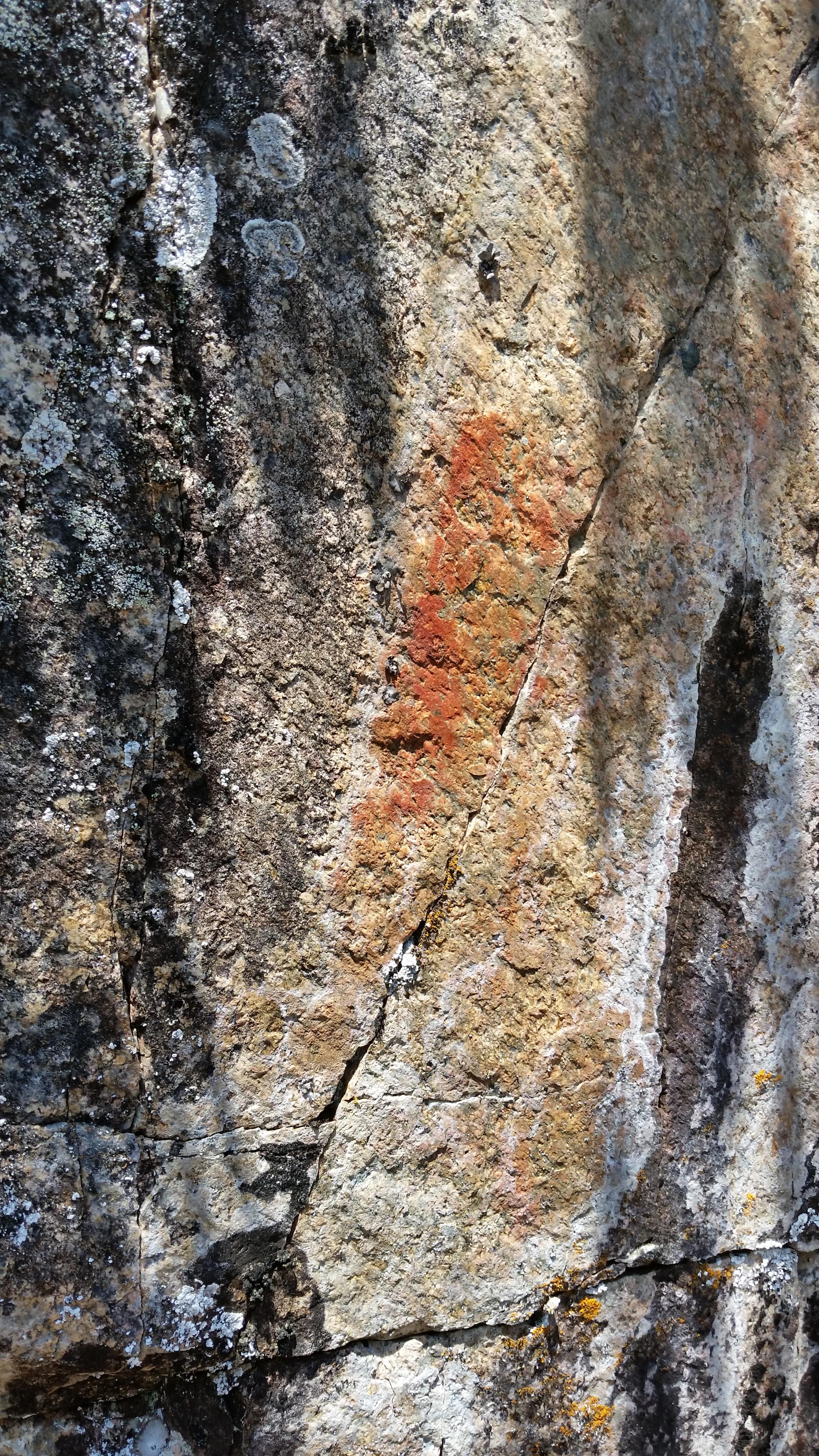
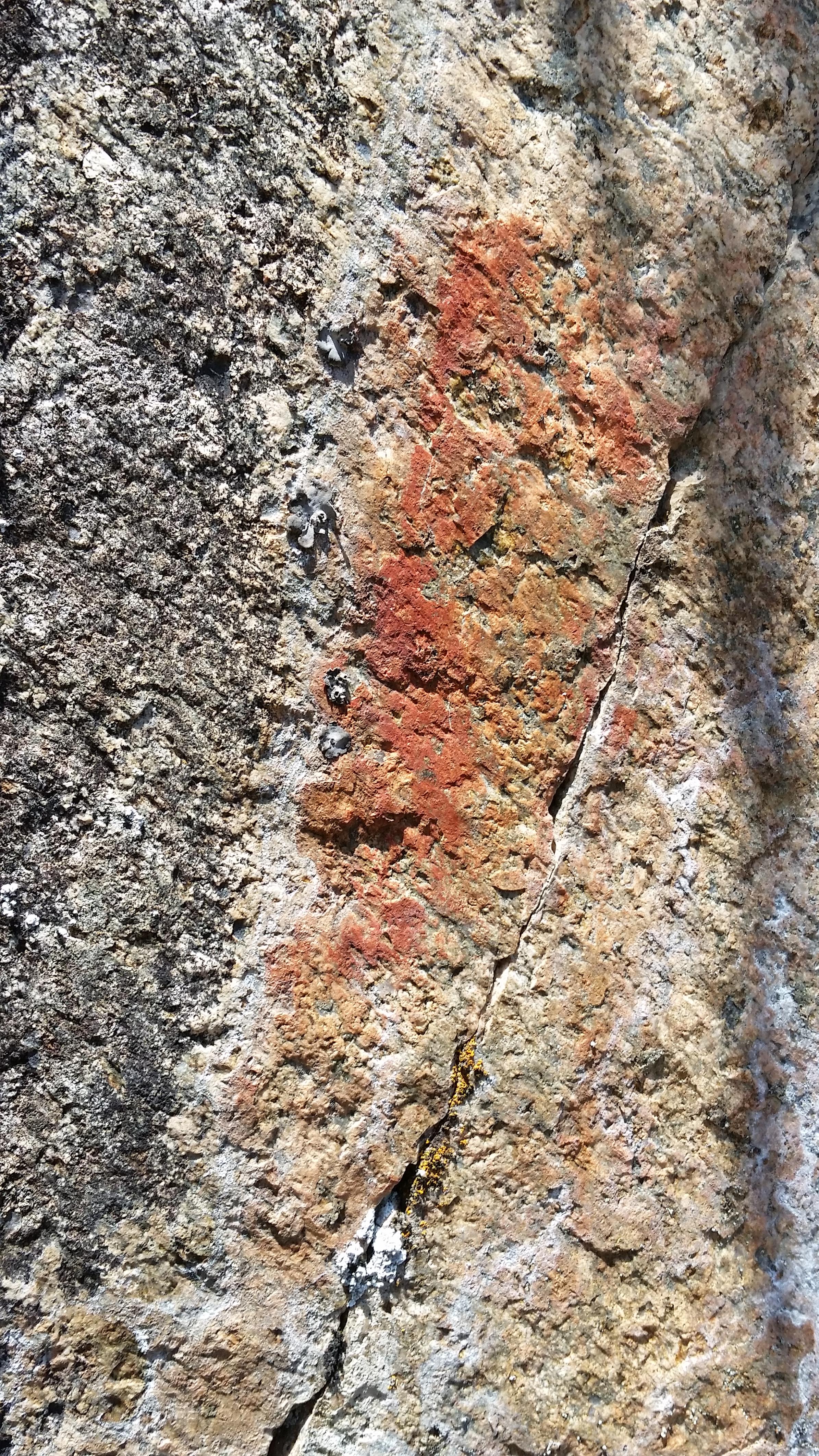
Last month during a trip on the Granite River I searched for pictographs along the way, since both the Northwoods Memories site and the Michael Dudzik document mention pictograph(s) in the Granite Lake/Granite River area. The only apparent pictograph I found was a nondescript smear located a few feet above the water on a cliff overhang along the border near Granite Lake at LAT/LONG 48.147733, -90.778563. See pictures below of this possible Granite River pictograph. Has anyone else noticed this pictograph? Are there any others in the Granite River area that I missed?


As Inspector13 notes in an old thread, the Minnesota Archaeological Society has documents citing BWCA pictographs. Some of these include descriptions by State Geologist Newton Winchell, AJ Hill, and TH Lewis from 1911, and Armin Arndt from 1935. An especially interesting article, Visions in Stone: The Rock Art of Minnesota by Michael Dudzik lists pictographs and petroglyph sites in Minnesota, including pictographs at Seagull, Fishdance, Crooked, and Crooked Lake #1, Island River, Jordan, Polly, Kekekabic, Hegman, King Williams Narrows, Burntside, Rocky Lake, Beatty Portage, Red Rock Lake, and the Granite River.
Some of these pictograph locations are very well known, others are completely undocumented in any publicly available source. For example, no one I have ever talked to knows anything about pictographs on Polly Lake. To my knowledge, there are no details anywhere about the reported pictograph(s) on the Granite River. The Northwoods Memories site mentions plans to publish information about pictographs on Ottertrack Lake, but no further details are given. In short, I suspect that there remain many little-known pictograph sites in the BWCA/Quetico, and I'm very curious about tips on where to find them and what's out there.
Last month during a trip on the Granite River I searched for pictographs along the way, since both the Northwoods Memories site and the Michael Dudzik document mention pictograph(s) in the Granite Lake/Granite River area. The only apparent pictograph I found was a nondescript smear located a few feet above the water on a cliff overhang along the border near Granite Lake at LAT/LONG 48.147733, -90.778563. See pictures below of this possible Granite River pictograph. Has anyone else noticed this pictograph? Are there any others in the Granite River area that I missed?

09/16/2019 05:52PM
Bushpilot: "There are some on the east end Burntside lake just outside of Ely. However they are on private property, so the location is kept on the down low out of respect for the property owner. "
Yes, I knew about the Burntside pictographs, but I didn't mention them here because of the private property issue. I believe Michael Furtman's book gives enough clues to find them.


09/17/2019 12:13AM
Fishdance Lake. Kinda cool. Nice area too. Not spectacular or anything. Not sure what your expectations are. Gotta look close in the most logical spot, then you’re like, yo, I see em now! High five me old hand on a rock face.
Something about a cryptic message from a person from a culture long past...
A worthy pursuit. Doesn’t matter why. Have fun.
Cheers, scat
Something about a cryptic message from a person from a culture long past...
A worthy pursuit. Doesn’t matter why. Have fun.
Cheers, scat

09/18/2019 09:16AM
It would have been more helpful of me to have at least named the sources I read, rather than typing those vague references. Perhaps I had been influenced by the redacted documents. I doubt I could find them again either.
That doesn’t look like lichen to me, and the Dudzik paper does list the Granite River pictos as indistinct, so maybe that’s it. Its placement is also a common characteristic of most of the them in the BW.
09/18/2019 11:26AM
inspector13: "It would have been more helpful of me to have at least named the sources I read, rather than typing those vague references. Perhaps I had been influenced by the redacted documents. I doubt I could find them again either.
That doesn’t look like lichen to me, and the Dudzik paper does list the Granite River pictos as indistinct, so maybe that’s it. Its placement is also a common characteristic of most of the them in the BW."
Thanks Inspector13 for your thoughts. If you ever manage to dig up those documents, please link them here. Would be neat to read! I'm hoping to get in touch with the Superior National Forest archaeologists... perhaps they can help me with my questions.
By the way, I noticed in your comments in the old thread that you seemed to think the Dudzik document was describing a petroglyph at Curtain Falls in the BWCA. For the record, that reference was to Curtain Falls in the Saint Croix River Dalles, perhaps the same one mentioned by jwartman59 above? There are no petroglyphs in the BWCA, and just a single caribou petroglyph in the Quetico on Agnes Lake.
Related question: Does anyone have details on the northeastern MN petroglyphs at Nett Lake and near the Rainy River, shown in the Dudzik document?
09/18/2019 01:40PM
My confusion probably came from seeing a picture of the Agnes Lake petroglyphs and not remembering their location. I do remember reading this redacted version of American Indian Rock Art and seeing the version you linked also.
Have you seen these pictures for the Nett Lake pictos?
1
2
09/18/2019 04:23PM
Good stuff! Thanks for the links. I had not seen those cool historic photos from the Nett Lake, Spirit Island site. Here's another Nett Lake photo which really puts the petroglyphs into their context.
Do you know anything about the partially redacted "Manitou" petroglyph site, which appears from the Dudzik map to be located somewhere near Birchdale MN?
Do you know anything about the partially redacted "Manitou" petroglyph site, which appears from the Dudzik map to be located somewhere near Birchdale MN?
09/19/2019 08:11AM
Kelso: "Good stuff! Thanks for the links. I had not seen those cool historic photos from the Nett Lake, Spirit Island site. Here's another Nett Lake photo which really puts the petroglyphs into their context.
Do you know anything about the partially redacted "Manitou" petroglyph site, which appears from the Dudzik map to be located somewhere near Birchdale MN?"
I was about to change my terminology to "images" after seeing the pictures I linked here. It gets confusing when the wrong word is used.
There is more info on the Nett Lake images in the book Wisconsin Archeologist on pages 146 and 147. Notice that the petroglyphs were there before the Bois Forte Band arrived.
I’m guessing the "Manitou" reference is for Manitou Rapids. These people also thought that but didn’t find anything.
09/19/2019 10:30AM
I like that theory about Manitou Rapids. Dewdney (pg 114) writes, "Mishipizhiw is also a supernatural creature, highly dangerous, who inhabits the rapids on some streams; for instance, the Manitou Rapids on the Rainy River, near Emo." This leads me to wonder if Dewdney heard stories about Manitou Rapids, but for some reason didn't find anything or didn't check, so the petroglyph wasn't confirmed until the 1988 State Archaeologist site report.
09/19/2019 10:59AM
By the way, while trying to find more info on the Rainy River glyphs I saw that pictos were found on the west side of Surveyor’s Island, a couple miles up from Kettle Falls, in Rainy Lake. (See pp 116-117)
Currently they look like two indistinct smears, but a former commercial fisherman on that lake said they were identifiable as two hand prints well into the 20th century. Higher up the rock face from those are a couple of forms mostly obscured by lichen growth. I wonder what the Granite River one was...
09/19/2019 11:20AM
inspector13: "By the way, while trying to find more info on the Rainy River glyphs I saw that pictos were found on the west side of Surveyor’s Island, a couple miles up from Kettle Falls, in Rainy Lake. (See pp 116-117)
Currently they look like two indistinct smears, but a former commercial fisherman on that lake said they were identifiable as two hand prints well into the 20th century. Higher up the rock face from those are a couple of forms mostly obscured by lichen growth. I wonder what the Granite River one was? "
Yes, I saw that document too. Based on that document and the Dewdney Book, I get the impression that there are many unpublicized picto sites in/near Voyageurs National Park, especially on the Canadian side of Namakan Lake... someday I'll have to spend time searching the islands and bays of Namakan, since I've never paused there while paddling through.
Related: Do you know anything about the King William's Narrows site? Can't find any sources indicating the precise location.
Starting to build a Google Map with locations of all the picto sites I've heard about:
09/19/2019 12:59PM
Cool.
Kelso:"Related: Do you know anything about the King William's Narrows site? Can't find any sources indicating the precise location. "
I don’t, but it looks like the people at Crane Lake Wilderness Lodge or Nelson’s Resort might know. I saw a trip report that implies they are located north of the King Narrows campsite by “Face in the Rock”. (Probably a mimetolith somewhere in the narrows.)
Edit: A book by Grace Rajnovich called Reading Rock Art: Interpreting the Indian Rock Paintings of the Canadian Shield shows sites as far north and west as the Churchill River and Lac La Ronge in Saskatchewan. Lots in the vicinity of Lake of the Woods too.
09/26/2019 10:47AM
Some updates on the picto research:
- The Granite Lake pictograph images shown above in the original post are the correct site, confirmed to me by Lee Johnson (Superior National Forest Archaeologist) and Bob Evans (Northwoods Memories). Bob Evans informed me that he has used image enhancement to identify additional images at the Granite Lake site not visible with the naked eye. This information will be included in a book he hopes to publish in the coming year.
- Lee Johnson confirmed that there is an authentic pictograph on Polly Lake. He recalled that it was located "on the NE side close to a river or creek opening".
- Johnson described the well-known but highly unusual anthropomorphic pictograph at Island River as "a reduction image made by scraping moss, greenish in color".
- Johnson and Evans both believe that the recently reported pictographs near a campsite on South Hegman Lake are modern fakes.
- Johnson also believes that the handprints on the boulder in the campsite on Finger Lake is a modern fake.
- Johnson has never heard of the Red Rock Lake pictograph mentioned in the Dudzik document.
- Johnson confirmed that there are indeed authentic pictographs on Ottertrack Lake on the Canadian side near the Benny Ambrose memorial plaque.
- Johnson described to me a single "butterfly-shaped" pictograph image that I was not aware of located on Jackfish Bay of Basswood Lake "northwest of the Pipestone Bay opening".
09/26/2019 01:13PM
Kelso: "- Lee Johnson confirmed that there is an authentic pictograph on Polly Lake. He recalled that it was located "on the NE side close to a river or creek opening"."
So probably in Polly’s eastern arm? There’s a creek coming in one of the bays from the east.
10/01/2019 08:01PM
I recall possibly seeing something on the stretch coming into Jordan from the east side. Ones like on crooked I always wondered why they put on the map. They really aren’t much to see comparably. I wonder who went home with red hands from finger lake. Speaking of finger, I wonder if there was a print left!
Nctry
10/01/2019 08:39PM
Kelso: "g".
- Johnson described the well-known but highly unusual anthropomorphic pictograph at Island River as "a reduction image made by scraping moss, greenish in color".
"."
The last time I was at the Island river pictographs you could see someone's initials scraped into the lichen. "JWC". About 5 years ago.

Raised by wolves!

Subscribe to Thread
Become a member of the bwca.com community to subscribe to thread and get email updates when new posts are added. Sign up Here
Community Links
 Search BWCA.com
 Donate
 Featured Sponsor
