|
 Boundary Waters Quetico ForumWinter Camping and ActivitiesAtikokan to Ely
|
Author
Text
")

12/10/2019 01:16PM
Hi All,
Looking for thoughts on a potential Atikokan to Ely Winter Route. Last year my brother and I did a 40+ mile trek from Moose Lake to Saganaga in March and we are looking for our next trek route. We have thrown around the idea of going from Atikokan to Ely as it would be a cool trip but while we have lots of experience in the BWCA (Summer & Winter) we are booth newbies when it comes to the Quetico.
Our initial thought was to pick a winter route but then do the route first in the summer. This would allow us to get familiar with the route and use a GPS device to map it all out with waypoints for portages and other POIs in the summer when it is easier and the conditions are more forgiving.
My question for the masses are the following:
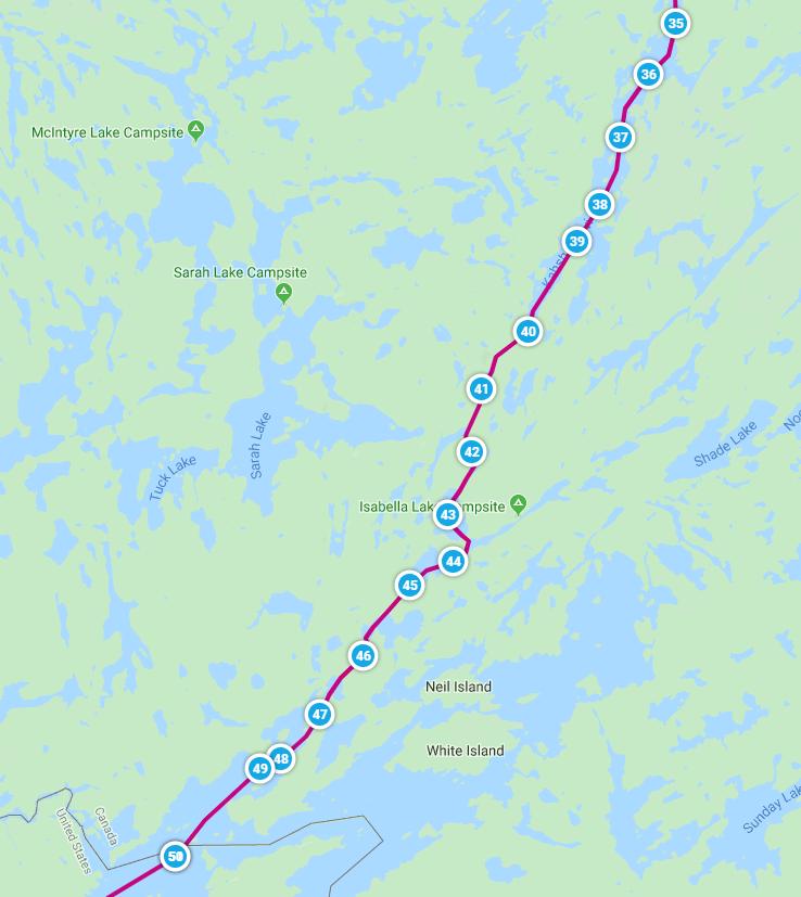
1) What is the best winter route for doing this? (Trying to minimize portages, total distance traveled, and fast moving/open water in the winter) I have attached a pictures and included a link to a map (see bottom of post) of our first draft of a route: Pickerel Lake to Fall Lake via the Kahshahpiwi Lake.
2) How does US-Canada border crossings work in the winter? Are there still stations you need to check in at in addition to having the remote border crossing permit?
3) Does anyone have experience doing a winter trip from Atikokan to Ely who would be willing to talk (email or phone)?
4) Any other advice or thoughts people have on this topic
Thanks.
Route Link (Map My Run)


Looking for thoughts on a potential Atikokan to Ely Winter Route. Last year my brother and I did a 40+ mile trek from Moose Lake to Saganaga in March and we are looking for our next trek route. We have thrown around the idea of going from Atikokan to Ely as it would be a cool trip but while we have lots of experience in the BWCA (Summer & Winter) we are booth newbies when it comes to the Quetico.
Our initial thought was to pick a winter route but then do the route first in the summer. This would allow us to get familiar with the route and use a GPS device to map it all out with waypoints for portages and other POIs in the summer when it is easier and the conditions are more forgiving.
My question for the masses are the following:
1) What is the best winter route for doing this? (Trying to minimize portages, total distance traveled, and fast moving/open water in the winter) I have attached a pictures and included a link to a map (see bottom of post) of our first draft of a route: Pickerel Lake to Fall Lake via the Kahshahpiwi Lake.
2) How does US-Canada border crossings work in the winter? Are there still stations you need to check in at in addition to having the remote border crossing permit?
3) Does anyone have experience doing a winter trip from Atikokan to Ely who would be willing to talk (email or phone)?
4) Any other advice or thoughts people have on this topic
Thanks.
Route Link (Map My Run)


Reply
Reply with Quote
Print
Top
Bottom
Previous
Next

12/10/2019 09:29PM
Not much help but if start in Canada crossing at IF or Pigeon River, you don't need an RABC.
As far as routes, they use to run a race from Ft Dawson to PP (to Ely actually but last one was to PP - too many border crossing issues). I only know it included Kashapiwi, Isabella, North Bay, and so on to PP.
I think permits are same as Sumer but call office. They can probably tell you what will be plowed. I think Ft Dawson camp ground is open year round and has yurts, but can could be mistaken.
Sounds wonderful. Wish I could keep up.
")

12/18/2019 04:17PM
billconner: "Not much help but if start in Canada crossing at IF or Pigeon River, you don't need an RABC.
As far as routes, they use to run a race from Ft Dawson to PP (to Ely actually but last one was to PP - too many border crossing issues). I only know it included Kashapiwi, Isabella, North Bay, and so on to PP.
I think permits are same as Sumer but call office. They can probably tell you what will be plowed. I think Ft Dawson camp ground is open year round and has yurts, but can could be mistaken.
Sounds wonderful. Wish I could keep up."
Winter permits are self serve at most entry points.
I know people have went from Atikoken to Canada Agnes and back. My biggest concerns and effort would be current area and slush.
If your going to do it. I highly recommend Middle of March-Long days and usually much warmer.
I have skiied up to Canadian Agnes in the winter from Moose lake entering point.
In the back of my mine it seems like someone did a article on it your proposed route.
They also do a ski marathon from Atikoken to Pickeral-than come out French lake each year. It is a one day deal.
I like the idea,do it in the summer first.
12/19/2019 02:05PM
Thanks all. The information about the Canadian side is particularly helpful. If we can piggy back off of an event or an area where there is an established winter trail that would make a big difference.
Our tentative plan would be to start in Canada. We have done all our other Winter trips in March as it is warmer and longer days. Obviously slush and snow depth are things you cannot control. One has to hope for the best and plan for the worst (and be willing to not do the trip if conditions are not right...too much slush, too much deep snow, or too cold of temperatures).
Sounds like Anges could be the more common route than Kahshahpiwi. Is there a lot of fast moving water along the route into Agnes from the Canada side? Good to know Pinetree has skied into Anges from Moose in the winter.
Been looking for articles about similar trips. Found some from other seasons and past races but no winter ones. If anyone is aware of one I would appreciate getting the link shared.
12/19/2019 02:37PM
Dumb permitting question.
So if we are starting in Canada and crossing the border at International Falls (in a car) do we need any type of permit to re-enter the US in a remote location? (Essentially a reverse RABC). Again considering doing this both in the Summer and Winter.
Thanks.
So if we are starting in Canada and crossing the border at International Falls (in a car) do we need any type of permit to re-enter the US in a remote location? (Essentially a reverse RABC). Again considering doing this both in the Summer and Winter.
Thanks.
12/19/2019 05:25PM
TuscTraveler: "Dumb permitting question.
So if we are starting in Canada and crossing the border at International Falls (in a car) do we need any type of permit to re-enter the US in a remote location? (Essentially a reverse RABC). Again considering doing this both in the Summer and Winter.
Thanks."
You don't need a permit, but you do need to report entry into the USA. You can do that at a CBP office (not sure if the one in Ely is still open, it used to just be open in the summer) or you can use the Roam App. Here's a link to the app: CBP Roam App
Make sure to have your passports with you and if you use the Roam App do it in Ely, don't drive home and try to check-in. They don't like that.
Andy
12/19/2019 06:13PM
Quetico ranger Chris Stromberg is a avid cross country skiier and back country lover, I believe his son has been formed a Outfitting group that caters to back country skiing. This was a few years ago.
But Chris would be full of great information.
But Chris would be full of great information.
12/20/2019 01:36PM
Thanks for the permitting information. We plan to have our passports on us and check in (in person or on the app). This helps a lot.
I will see if I can find Chris Stromberg online and reach out.
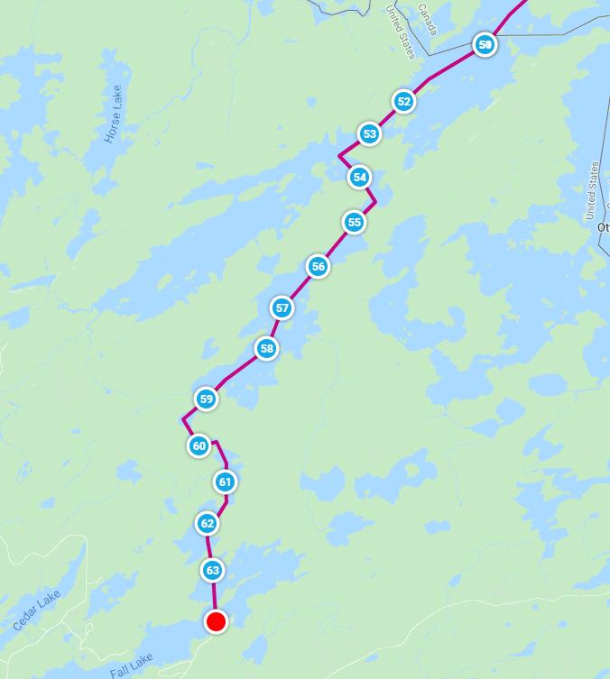
I also have updated the proposed route based on the suggestion of Lake Agnes (nice to avoid portages) and some research of the area and portages near Pickerel Lake. An outstanding route question I am now trying to answer is if the road to Stanton Bay on Pickerel Lake is plowed in the winter or if we would have to start on French Lake by the Trans Canada Highway in the Winter? (Having to start on French Lake would add 7 miles to the trip) Anyone have any idea or have contacts from Canada/Atikokan who might know?
Pickerel to Moose Lake Route (Via Agnes)
Thanks again for everyone's input.
I will see if I can find Chris Stromberg online and reach out.
I also have updated the proposed route based on the suggestion of Lake Agnes (nice to avoid portages) and some research of the area and portages near Pickerel Lake. An outstanding route question I am now trying to answer is if the road to Stanton Bay on Pickerel Lake is plowed in the winter or if we would have to start on French Lake by the Trans Canada Highway in the Winter? (Having to start on French Lake would add 7 miles to the trip) Anyone have any idea or have contacts from Canada/Atikokan who might know?
Pickerel to Moose Lake Route (Via Agnes)
Thanks again for everyone's input.
11/22/2024 05:14PM
TuscTraveler: "Thanks for the permitting information. We plan to have our passports on us and check in (in person or on the app). This helps a lot.
I will see if I can find Chris Stromberg online and reach out.
I also have updated the proposed route based on the suggestion of Lake Agnes (nice to avoid portages) and some research of the area and portages near Pickerel Lake. An outstanding route question I am now trying to answer is if the road to Stanton Bay on Pickerel Lake is plowed in the winter or if we would have to start on French Lake by the Trans Canada Highway in the Winter? (Having to start on French Lake would add 7 miles to the trip) Anyone have any idea or have contacts from Canada/Atikokan who might know?
Pickerel to Moose Lake Route (Via Agnes)
Thanks again for everyone's input. "
Did you end up doing this route? I've been looking to do something similar. How did you handle transportation? Did you leave cars at the entry and exit trailheads?
Reply
Reply with Quote
Print
Top
Bottom
Previous
Next

Subscribe to Thread
Become a member of the bwca.com community to subscribe to thread and get email updates when new posts are added. Sign up Here
Community Links
 Search BWCA.com
 Donate
 Featured Sponsor
