|
 Boundary Waters Quetico ForumTrip Planning Forum2021 Burns - Map?
|
 Forum Sponsor
Author
Text
01/21/2022 11:15AM
Anyone know where to find maps that accurately shows where last year's burns in the BWCA and Quetico were located? I'm looking to plan this year's trip and would like to minimize my time in a fresh burn. I haven't found anything great during my web searches.
Reply
Reply with Quote
Print
Top
Bottom
Previous
Next
")


01/21/2022 01:26PM
I don’t think the Fourtown fire really affected anything from a Tripping standpoint. It was just east of Fourtown but didn’t get near the other trippable lakes to the east.
Overall I’d say that nothing in the BWCA was affected negatively from a campsites burned and trees being down last year by the fires.
Parts of Quetico are affectedand will require planning around fire burned areas.
Ryan
Overall I’d say that nothing in the BWCA was affected negatively from a campsites burned and trees being down last year by the fires.
Parts of Quetico are affectedand will require planning around fire burned areas.
Ryan

01/23/2022 09:47PM
Superior National Forest Facebook page has the maps. I saved all of the pdf files. Maybe I can get them up here sometime.
Fourtown site #1099 was burned pretty badly in a backburn operation.
Fourtown site #1099 was burned pretty badly in a backburn operation.
"You can observe a lot just by watching." -- Yogi Berra
01/24/2022 07:49PM
schweady: "Superior National Forest Facebook page has the maps. I saved all of the pdf files. Maybe I can get them up here sometime.
Fourtown site #1099 was burned pretty badly in a backburn operation.
"
Here you go. As has been said, not a lot of these burn areas will affect paddling routes as much as some of the major fires of the past. We remember them as affecting a much larger area of closure than the size of the actual burn footprint.
----
I collected information on 38 named wildfires in 2021. (SNF identified 65 fires reported on the Forest in 2021, 29 of which were caused by humans.) I found maps showing fire perimeters — or at least locations — for 19 of them.
Bezhik Fire - west of Big Moose Lake
Perimeter map - May 20, 2021

Hassel, Picketts, Astray, Delta Lake Fires
Locations map - July 16, 2021

Bear Creek, Phantom Creek, Sundial South, Bunggee, Fourtown Lake, Vivid Lake, Ima, Delta Lake, Slowfoot, Agamok, Beth Fires
Locations map - August 3, 2021

Whelp Creek Fire
Perimeter map - August 20, 2021

John Ek Fire
Perimeter map - September 1, 2021

Greenwood Fire (outside of BWCAW)
Perimeter map - September 12, 2021

"You can observe a lot just by watching." -- Yogi Berra
01/24/2022 09:07PM
I was up in the Greenwood fire area in mid October, after the fire subsided. I was visiting family along Hwy 2 on Sand Lake. I know it may seem odd but I got the sense the forest was already recovering…rebounding quickly where they were perimeter burning along the road to contain the fires. I was really surprised. Yes, in the middle of a burn it can look devastating but on the edges, etc it can recover quickly/look like the damage isn’t that bad (that’s not to say it isn’t). Furthermore, not all the indicated fire area (red shade on the maps posted above) is the same.
I guess if I have a point to this post it’s that a simple map may not do justice to the reality of the situation or tell you what to expect. And things will change quickly in the wilderness. Mother Nature is amazing. A simple map can be somewhat misleading. Below is a map of the Quetico fires in 2021 that I sort of like. It does a decent job of showing and describing the relative impact on various areas that were subject to fires this past summer in Quetico. I don’t think anything like this was put together for the BWCA. Nor do I believe the BWCA had the burn area in 2021 equivalent to that of Quetico, as far as I know.

I guess if I have a point to this post it’s that a simple map may not do justice to the reality of the situation or tell you what to expect. And things will change quickly in the wilderness. Mother Nature is amazing. A simple map can be somewhat misleading. Below is a map of the Quetico fires in 2021 that I sort of like. It does a decent job of showing and describing the relative impact on various areas that were subject to fires this past summer in Quetico. I don’t think anything like this was put together for the BWCA. Nor do I believe the BWCA had the burn area in 2021 equivalent to that of Quetico, as far as I know.

02/05/2022 03:04PM
Quetico PP got pounded but a lot of the effects were in some pretty remote areas:

The image is from here: Ontario Forest Fires
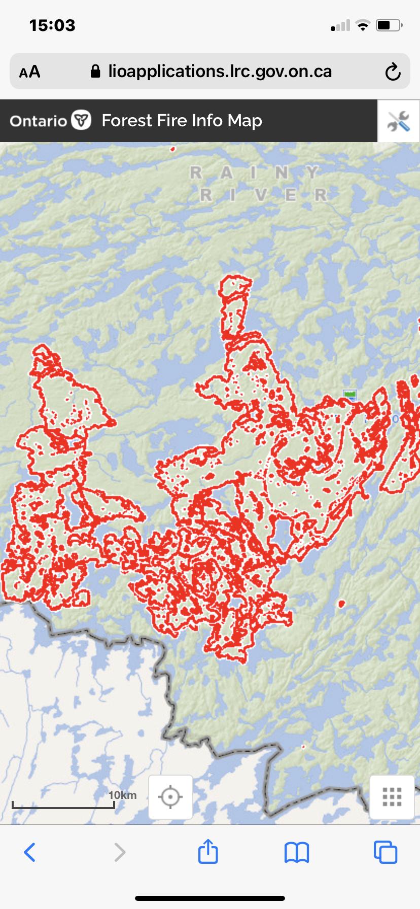
The image is from here: Ontario Forest Fires
Reply
Reply with Quote
Print
Top
Bottom
Previous
Next

Subscribe to Thread
Become a member of the bwca.com community to subscribe to thread and get email updates when new posts are added. Sign up Here
Community Links
 Search BWCA.com
 Donate
 Featured Sponsor
