|
 Boundary Waters Quetico ForumListening Point - General Discussion Flooded campgrounds and washed out road
|
Author
Text
")

05/12/2022 05:14PM
I see the NFS posted on their Facebook page some pictures from today. Looks like some roads are flooded or washed out and closed. Also Fall Lake campground has a lot of water in places.
Shouldn't have any problem with low water in the streams or lakes for a while! Forest Road 313 in the Gunflint District
Shouldn't have any problem with low water in the streams or lakes for a while! Forest Road 313 in the Gunflint District


05/13/2022 06:35AM
Wouldn't be surprised to more pics like the one above once crews can get out.
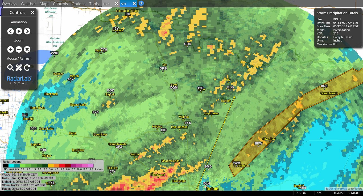
Estimated rainfall since yesterday morning.

Flash Flood Warning for the entire N SHore-
Flash Flood Warning
MNC031-075-137-131415-
/O.EXT.KDLH.FF.W.0001.000000T0000Z-220513T1415Z/
/00000.0.ER.000000T0000Z.000000T0000Z.000000T0000Z.OO/
BULLETIN - EAS ACTIVATION REQUESTED
Flash Flood Warning
National Weather Service Duluth MN
455 AM CDT Fri May 13 2022
The National Weather Service in Duluth has extended the
* Flash Flood Warning for...
Southwestern Cook County in northeastern Minnesota...
Eastern Lake County in northeastern Minnesota...
Eastern St. Louis County in northeastern Minnesota...
* Until 915 AM CDT.
* At 455 AM CDT, Doppler radar indicated thunderstorms produced
heavy rain across southern portions of the warned area. Between 1
and 2 inches of rain have fallen in the last 12 hours. Flash
flooding is ongoing or expected to begin shortly.
HAZARD...Flash flooding caused by thunderstorms.
SOURCE...Radar.
IMPACT...Flash flooding of small creeks and streams, urban
areas, highways, streets and underpasses as well as
other poor drainage and low-lying areas. The main area
of concern is Highway 61, where flash flooding may
lead to bridge washouts, especially at the Cascade
River. Flash flooding may quickly escalate once rivers
exceed culvert capacity.
* Some locations that will experience flash flooding include...
Grand Marais, Two Harbors, Silver Bay, Grand Portage, Lutsen,
Tofte, Beaver Bay, Taconite Harbor, Sugar Loaf Cove, Little
Marais, Illgen City, Finland, Split Rock Lighthouse, Castle
Danger, Hovland, Larsmont, Knife River, Alger, Temperance River
State Park and White Pine Lake.
PRECAUTIONARY/PREPAREDNESS ACTIONS...
Turn around, don`t drown when encountering flooded roads. Most flood
deaths occur in vehicles.
Be especially cautious at night when it is harder to recognize the
dangers of flooding.
Please report observed flooding to local emergency services or law
enforcement and request they pass this information to the National
Weather Service when you can do so safely.
Estimated rainfall since yesterday morning.
Flash Flood Warning for the entire N SHore-
Flash Flood Warning
MNC031-075-137-131415-
/O.EXT.KDLH.FF.W.0001.000000T0000Z-220513T1415Z/
/00000.0.ER.000000T0000Z.000000T0000Z.000000T0000Z.OO/
BULLETIN - EAS ACTIVATION REQUESTED
Flash Flood Warning
National Weather Service Duluth MN
455 AM CDT Fri May 13 2022
The National Weather Service in Duluth has extended the
* Flash Flood Warning for...
Southwestern Cook County in northeastern Minnesota...
Eastern Lake County in northeastern Minnesota...
Eastern St. Louis County in northeastern Minnesota...
* Until 915 AM CDT.
* At 455 AM CDT, Doppler radar indicated thunderstorms produced
heavy rain across southern portions of the warned area. Between 1
and 2 inches of rain have fallen in the last 12 hours. Flash
flooding is ongoing or expected to begin shortly.
HAZARD...Flash flooding caused by thunderstorms.
SOURCE...Radar.
IMPACT...Flash flooding of small creeks and streams, urban
areas, highways, streets and underpasses as well as
other poor drainage and low-lying areas. The main area
of concern is Highway 61, where flash flooding may
lead to bridge washouts, especially at the Cascade
River. Flash flooding may quickly escalate once rivers
exceed culvert capacity.
* Some locations that will experience flash flooding include...
Grand Marais, Two Harbors, Silver Bay, Grand Portage, Lutsen,
Tofte, Beaver Bay, Taconite Harbor, Sugar Loaf Cove, Little
Marais, Illgen City, Finland, Split Rock Lighthouse, Castle
Danger, Hovland, Larsmont, Knife River, Alger, Temperance River
State Park and White Pine Lake.
PRECAUTIONARY/PREPAREDNESS ACTIONS...
Turn around, don`t drown when encountering flooded roads. Most flood
deaths occur in vehicles.
Be especially cautious at night when it is harder to recognize the
dangers of flooding.
Please report observed flooding to local emergency services or law
enforcement and request they pass this information to the National
Weather Service when you can do so safely.
The two loudest sounds known to man: a gun that goes bang when it is supposed to go click and a gun that goes click when it is supposed to go bang.
05/13/2022 04:14PM
cyclones30: "SpokaneFlyer: "I was at Cascade River last night and it looks pretty bad. Water was almost up to the top of the bridge!"
Yeah, Cascade @ 61 needs a bigger bridge/tunnel. She's gonna go over the road or cut around and through the road "
Hoping I make it up to Grand Maris in a few weeks! YIKES!
If Hwy 61 does get closed because the cascade washes out Hwy 61… is there any way up to the Gunflint Trail or is 61 the only way?
“The Wilderness holds answers to more questions than we have yet learned to ask.” - Nancy Newhall

05/13/2022 06:28PM
cyclones30: "SpokaneFlyer: "I was at Cascade River last night and it looks pretty bad. Water was almost up to the top of the bridge!"
Yeah, Cascade @ 61 needs a bigger bridge/tunnel. She's gonna go over the road or cut around and through the road "
Grand Marais photographer took these videos of the Cascade just today and posted on his FaceBook page here
Very scary stuff.
We all have to believe in something. I believe I'll go paddle.
05/13/2022 07:57PM
MN_Lindsey: "If Hwy 61 does get closed because the cascade washes out Hwy 61… is there any way up to the Gunflint Trail or is 61 the only way?"
With a little effort and decent maps you can probably construct a route via F.S. roads. Seems to me I've seen signs pointing towards Lutsen around the Brule Lake area. Realizing of course that Lutsen is south of the Cascade river but there are roads that connect.
05/13/2022 08:54PM
Just drove to the cities today down the Gunflint trail. Water was across the road one spot a little north of the divide. Almost over the road in another spot. No problem though the water wasn’t even an inch deep. 
Gooseberry Falls

Gooseberry Falls
You're going to HELL and you're going to drag me with ya!! -Gunsmoke
05/13/2022 09:25PM
jhb8426: "MN_Lindsey: "If Hwy 61 does get closed because the cascade washes out Hwy 61… is there any way up to the Gunflint Trail or is 61 the only way?"
With a little effort and decent maps you can probably construct a route via F.S. roads. Seems to me I've seen signs pointing towards Lutsen around the Brule Lake area. Realizing of course that Lutsen is south of the Cascade river but there are roads that connect."
True, but a lot of those back roads are having problems of their own. Call ahead about county roads and forest roads. From last week: "Don't be the guy that apparently didn't know what 'Closed' means. It cost him a fairly large towing fee."
"You can observe a lot just by watching." -- Yogi Berra
05/13/2022 09:38PM
jhb8426: "MN_Lindsey: "If Hwy 61 does get closed because the cascade washes out Hwy 61… is there any way up to the Gunflint Trail or is 61 the only way?"
With a little effort and decent maps you can probably construct a route via F.S. roads. Seems to me I've seen signs pointing towards Lutsen around the Brule Lake area. Realizing of course that Lutsen is south of the Cascade river but there are roads that connect."
Yeah I saw that facebook post or others like it. Oh yep there is! Take CR 4 up towards Eagle Mountain to The Grade, and it connects near Devil Track Lake, and on to Grand Maria’s via Devil Track Rd ! Good idea!
I drove that exact route last year when I hiked Eagle Mountain, and then needed gas in GM… stayed at a free Forest Service campground.
Have you guys seen the footbridge at High Falls at Tettegouche! About to end up in Lake Superior!
“The Wilderness holds answers to more questions than we have yet learned to ask.” - Nancy Newhall
05/13/2022 10:09PM
Years ago I was called to search for a missing couple in SE Minnesota. They had been staying in a campground on the Zumbro River. An intense thunderstorm dumped a boatload of water on the watershed above them. The campground manager knew the danger and got everyone to safer ground.
The couple decided to leave the campground in the dark. They drove up along the river toward home and made a turn across the river. What was normally a couple of culverts was now a hole twenty feet across and ten feet deep. It would have been virtually invisible in the dark.
When I got to where their van had been found, I saw that the roof had been torn off by the water. Sadly, both of them perished and were found over the next couple of days.
05/13/2022 11:10PM
MN_Lindsey: "...and on to Grand Maria’s via Devil Track Rd ! Good idea!"
Currently closed due to flooding. boreal.org
"You can observe a lot just by watching." -- Yogi Berra
Subscribe to Thread
Become a member of the bwca.com community to subscribe to thread and get email updates when new posts are added. Sign up Here
Community Links
 Search BWCA.com
 Donate
 Featured Sponsor
