|
 Boundary Waters Quetico ForumListening Point - General Discussion Spice Lake Fire
|
 Forum Sponsor

Author
Text
")
06/13/2023 08:41PM
I'm hearing from people in the USFS that they have a fire near Ogishkemuncie Lake in the BWCA. Approximately 30 acres with a high potential of development into a larger fire. It has been described as very active according to a USFS employee who I talked to. Fire is currently burning to the Northwest from what I heard.


06/14/2023 07:48AM
adam: "Map Location
Link to FIRMS"
from the FIRMS map, it doesn't look like anything has burned on Spice. It appears its that little NW bay of Ogish that is burning. wonder why they're calling it the Spice lake fire. Also, it doesn't look like it started near any campsites but is working its way towards some. Also from the FIRMS map, it looks like the fire is moving south but that could just be an incorrect interpretation on my end.
The winds are blowing south today and tomorrow... hopefully it contains itself by running into Ogish. Fingers crossed
06/14/2023 07:54AM
jwmiller39: "adam: "Map Location
Link to FIRMS"
from the FIRMS map, it doesn't look like anything has burned on Spice. It appears its that little NW bay of Ogish that is burning. wonder why they're calling it the Spice lake fire. Also, it doesn't look like it started near any campsites but is working its way towards some. Also from the FIRMS map, it looks like the fire is moving south but that could just be an incorrect interpretation on my end."
Lol how can you even tell from that map, it is not detailed at all....

06/14/2023 08:26AM
Bing: "Actually JWMiller39 is correct. Im familiar with this area and it is in one of the last bays on the west side of ogish and not far from the portage into Annie. And the smoke in the picture in a news article from last night is going south.
"
judging by the incredible amount of smoke haze in Duluth today, the winds are definitely blowing to the south
06/14/2023 08:36AM
Bing: "Actually JWMiller39 is correct. Im familiar with this area and it is in one of the last bays on the west side of ogish and not far from the portage into Annie. And the smoke in the picture in a news article from last night is going south.
"
BWCA subreddit has an aerial photo of it presumably from later yesterday. I can't really tell from the photo what direction it's going, I dont know that lake well enough.
Aerial Photo
06/14/2023 08:47AM
jwmiller39: "Bing: "Actually JWMiller39 is correct. Im familiar with this area and it is in one of the last bays on the west side of ogish and not far from the portage into Annie. And the smoke in the picture in a news article from last night is going south.
"
judging by the incredible amount of smoke haze in Duluth today, the winds are definitely blowing to the south"
No kidding, walked outside on the deck at like 6am and had to double check my clock to make sure it was actually 6am and not 4am! It's hazy.
06/14/2023 08:57AM
jwmiller39: "that photo is of the NW bay of Ogish looking south/southwest (roughly similar direction the wind is blowing in the pic). that little peninsula sticking out north is easily identifiable "
So is this a good thing? In the sense that the fire may dead-end itself with winds blowing South? Please let that be the case to give firefighters a chance to extinguish it quickly.

06/14/2023 09:53AM
AlexanderSupertramp: "jwmiller39: "that photo is of the NW bay of Ogish looking south/southwest (roughly similar direction the wind is blowing in the pic). that little peninsula sticking out north is easily identifiable "
So is this a good thing? In the sense that the fire may dead-end itself with winds blowing South? Please let that be the case to give firefighters a chance to extinguish it quickly. "
Fire grows faster downwind but it also burns through fuels on all sides and it can spot out ahead of the main fire as well.
06/14/2023 10:09AM
Jaywalker: "
Just guessing, but could be that it's just easier to spell? Easier to say too. "
makes sense!
USFS posted another aerial picture, this time looking north, and stated the fire is between Ogish and Spice. The aerial photo shows smoke coming from that Ogish shoreline and the wind is blowing to the south. You can see Spice in the picture also.
06/14/2023 11:13AM
toastedmarshmallow12: "No. Winds are reported from the direction they are coming from and not going. Like I said, let's get information from the experts and not a random person looking at a map with very little detail. "
There is quite a bit more to fire behavior than wind direction and without all information we should refrain from predicting fire behavior. Fire is a natural part of the ecosystem. Much of the bwca fire has been heavy suppressed causing heavy fuel loading which results in catastrophic fire behavior. So letting small areas burn is helpful for suppression efforts and forest health.
06/14/2023 12:50PM
Ahahn366: "toastedmarshmallow12: "No. Winds are reported from the direction they are coming from and not going. Like I said, let's get information from the experts and not a random person looking at a map with very little detail. "
There is quite a bit more to fire behavior than wind direction and without all information we should refrain from predicting fire behavior. Fire is a natural part of the ecosystem. Much of the bwca fire has been heavy suppressed causing heavy fuel loading which results in catastrophic fire behavior. So letting small areas burn is helpful for suppression efforts and forest health.
"
These are not the conditions where they a just going to let a fire burn.
06/14/2023 01:06PM
thegildedgopher: "Just heard on NPR that we are likely headed toward a partial closure of the BWCA. Specific Area tbd. I’m nervous, we have a Friday entry on Saganaga that looks to be in jeopardy."
The unfortunate outcome for the forest aside, the outfitters are never going to catch a break up there if this shit keeps happening and I don't suspect they can all survive with all the lost income. First the permit reduction, which hit the gunflint a lot worse than anywhere else, now another closure in just two years (potentially).
This is just shitty on many levels.
06/14/2023 01:11PM
toastedmarshmallow12: "Ahahn366: "toastedmarshmallow12: "No. Winds are reported from the direction they are coming from and not going. Like I said, let's get information from the experts and not a random person looking at a map with very little detail. "
There is quite a bit more to fire behavior than wind direction and without all information we should refrain from predicting fire behavior. Fire is a natural part of the ecosystem. Much of the bwca fire has been heavy suppressed causing heavy fuel loading which results in catastrophic fire behavior. So letting small areas burn is helpful for suppression efforts and forest health.
"
These are not the conditions where they a just going to let a fire burn. "
They did with Pagami Creek. Long story - short-- within 4 days myself as a professional weather forecaster saw the writing on the wall = BLOW UP. But those in control did little or nothing or waited till it was too late. I hope it doesn't come to this again-. With RH values in the next day or two rather high at night-- their best chance of putting this thing out (if they do that) is within 48 hours.
Winds will eventually go Southerly and gusty--- imagine that. spot forecast for fire
The two loudest sounds known to man: a gun that goes bang when it is supposed to go click and a gun that goes click when it is supposed to go bang.
06/14/2023 02:05PM
WhiteWolf: "toastedmarshmallow12: "Ahahn366: "toastedmarshmallow12: "No. Winds are reported from the direction they are coming from and not going. Like I said, let's get information from the experts and not a random person looking at a map with very little detail. "
There is quite a bit more to fire behavior than wind direction and without all information we should refrain from predicting fire behavior. Fire is a natural part of the ecosystem. Much of the bwca fire has been heavy suppressed causing heavy fuel loading which results in catastrophic fire behavior. So letting small areas burn is helpful for suppression efforts and forest health.
"
These are not the conditions where they a just going to let a fire burn. "
They did with Pagami Creek. Long story - short-- within 4 days myself as a professional weather forecaster saw the writing on the wall = BLOW UP. But those in control did little or nothing or waited till it was too late. I hope it doesn't come to this again-. With RH values in the next day or two rather high at night-- their best chance of putting this thing out (if they do that) is within 48 hours.
Winds will eventually go Southerly and gusty--- imagine that.
That's not how firefighting works. They don't put fires like this out. Also, they have more things to consider than just the weather. It's already been stated that public and firefighter safety is their priority. They have been moving campers off of nearby lakes. This area also has a lot of dead trees, again firefighter safety. I would also imagine with this heavy smoke aircraft are going to have a hard time. It's clear that they recognize the potential which is why there is going to be an area closure put in place.

06/14/2023 02:25PM
AlexanderSupertramp: "thegildedgopher: "Just heard on NPR that we are likely headed toward a partial closure of the BWCA. Specific Area tbd. I’m nervous, we have a Friday entry on Saganaga that looks to be in jeopardy."
The unfortunate outcome for the forest aside, the outfitters are never going to catch a break up there if this shit keeps happening and I don't suspect they can all survive with all the lost income. First the permit reduction, which hit the gunflint a lot worse than anywhere else, now another closure in just two years (potentially).
This is just shitty on many levels. "
Yeah, the best we can do to support them is to allow them to keep deposits toward future trips but even that doesn’t replace the hole they’ll be tossed into. My outfitters up there feel like family, I’m just wishing them safety and to avoid catastrophic loss to the environment and wildlife. Nature is brutal and it sure seems like things are getting worse every year. Disheartening to say the least.
Most afternoons for the past several months I have been sitting here at my desk daydreaming about our upcoming trip, maybe sneaking a peek at maps and making to-do lists. Here I sit 48 hrs from entry and it’s all up in the air. Sometimes plans don’t work out I guess.
06/14/2023 02:37PM
toastedmarshmallow12: "Fishman53: " Currently from Gunflint webcam. Firefighters??"
Yes"
Odd place for them to be staging if they are tackling a fire over on Ogish though no? Is there another fire somewhere we dont know about yet?
You would think they would be gearing up over on Seagull, seems like that would make the most sense logistically.
06/14/2023 02:41PM
AlexanderSupertramp: "toastedmarshmallow12: "Fishman53: " Currently from Gunflint webcam. Firefighters??
Yes"
Odd place for them to be staging if they are tackling a fire over on Ogish though no? Is there another fire somewhere we dont know about yet?
You would think they would be gearing up over on Seagull or Sag."
They flew people into fires in 2021. I would guess they are doing the same this time
06/14/2023 02:44PM
toastedmarshmallow12: "AlexanderSupertramp: "toastedmarshmallow12: "Fishman53: " Currently from Gunflint webcam. Firefighters??
Yes"
Odd place for them to be staging if they are tackling a fire over on Ogish though no? Is there another fire somewhere we dont know about yet?
You would think they would be gearing up over on Seagull or Sag."
They flew people into fires in 2021. I would guess they are doing the same this time"
Oh, are there float planes that dock there permanently? Because then that would make more sense.
06/14/2023 03:01PM
AlexanderSupertramp: "....Oh, are there float planes that dock there permanently? Because then that would make more sense."
They are not normally there. The one in the back left looks like one of the SNF beavers, normally based over by Ely. The one in the right foreground I do not recognize but looks like firefighting colors.
I just looked at the webcam live and both planes were gone, then just landed and pulled in while I watched. They are definitely loading the fire crew and gear up and taking them in. I would not be surprised if they also took that bunch of aluminum canoes in too. Seems they usually given them aluminum - kevlar burns too easy.
06/14/2023 03:11PM
thegildedgopher: "Just heard on NPR that we are likely headed toward a partial closure of the BWCA. Specific Area tbd. I’m nervous, we have a Friday entry on Saganaga that looks to be in jeopardy."
More info on a closure
https://knsiradio.com/2023/06/14/wildfire-sparks-closing-of-part-of-bwca/
06/14/2023 03:17PM
anthonylane: "thegildedgopher: "Just heard on NPR that we are likely headed toward a partial closure of the BWCA. Specific Area tbd. I’m nervous, we have a Friday entry on Saganaga that looks to be in jeopardy."
More info on a closure
https://knsiradio.com/2023/06/14/wildfire-sparks-closing-of-part-of-bwca/"
They say closure but fail to specify literally any details. What the heck.
06/14/2023 03:19PM
Jaywalker: "AlexanderSupertramp: "....Oh, are there float planes that dock there permanently? Because then that would make more sense."
They are not normally there. The one in the back left looks like one of the SNF beavers, normally based over by Ely. The one in the right foreground I do not recognize but looks like firefighting colors.
I just looked at the webcam live and both planes were gone, then just landed and pulled in while I watched. They are definitely loading the fire crew and gear up and taking them in. I would not be surprised if they also took that bunch of aluminum canoes in too. Seems they usually given them aluminum - kevlar burns too easy. "
it is a big lake close to the area in need that float planes can land and take off and not break any usfs boundary rules
06/14/2023 03:56PM
Per the Duluth News:
1:45 P.M. UPDATE: Superior National Forest leaders say they’re planning a “fairly large” closure area in the BWCA citing concerns the Spice Lake Fire could grow rapidly.
It will likely include Seagull Lake entry points and will force/keep a lot of campers out.
https://www.northernnewsnow.com/2023/06/14/30-acre-wildfire-burning-boundary-waters/
06/14/2023 04:12PM
The closure of seagull would be a precaution likely because that's the primary access point for Ogish. That said, if the fire marched west (not common, many BWCA fires head east or northeast with prevailing wind) it would be into Knife quickly which would cause larger closures. The convenient thing with where this fire is located is, if it does march east, it'll hit the Cavity Lake burn pretty soon after. Now, it has been 17 years since Cavity so it is capable of burning again, not a true fire break like a more recent one, but it definitely wouldn't turn into a massive crown fire like they are concerned about in the dead balsam/budworm stands.
06/14/2023 04:34PM
Fun to see the webcam. That Beaver is one fine aircraft.... loading in gear and fire crew then strapping on a couple canoes and off they go! Bravo
While some delve deep in mustie books in quest of learning rare, Ye wise folk walk by trees and brooks and gain of wisdom there.
06/14/2023 06:46PM
thegildedgopher: "Just heard on NPR that we are likely headed toward a partial closure of the BWCA. Specific Area tbd. I’m nervous, we have a Friday entry on Saganaga that looks to be in jeopardy."
We're heading in on Sag on Saturday. Where are you headed?
06/14/2023 06:47PM
analyzer: "thegildedgopher: "Just heard on NPR that we are likely headed toward a partial closure of the BWCA. Specific Area tbd. I’m nervous, we have a Friday entry on Saganaga that looks to be in jeopardy."
We're heading in on Sag on Saturday. Where are you headed?"
We are actually staying at Sagonto just across the border. I spoke with our contact there just moments ago and he was encouraging. Apparently there are 20 hotshots coming in from Colorado tomorrow so they are not sitting on their hands. He offered to reschedule us but told me as long as I was comfortable coming to plan to keep our entry as-is for Friday. I know they have been in some very hairy situations in the past and have hosted firefighters in their camp, and he seems to have a positive outlook. Fingers crossed tomorrow is a bad day for flames and a good day for those who seek to extinguish them.
06/14/2023 07:38PM
What I'm hearing is this: The fire is in a very difficult area to fight. What the USFS will do is stage firefighters a good distance away from the fire between lakes to create a perimeter to prevent the fire from getting past a certain point. They are expecting the fire to burn over 1,000 acres according to a USFS firefighter I talked to.

06/14/2023 09:34PM
SpokaneFlyer: "What I'm hearing is this: The fire is in a very difficult area to fight. What the USFS will do is stage firefighters a good distance away from the fire between lakes to create a perimeter to prevent the fire from getting past a certain point. They are expecting the fire to burn over 1,000 acres according to a USFS firefighter I talked to."
Oh man. 1000 acres isn't that much, but it's still pretty significant, and that's if it actually stops at 1000, though you said over 1000. I picked Moose Lake as my entry for my first trip back in 2018 because the Knife/Ima/Ensign area was unspoiled by burn, among other reasons. Let's hope the fire doesn't spoil those areas. This has only accelerated my desire to take as many trips as possible before any more burn. This will likely be the new normal...
06/15/2023 04:23AM
Photo of fire basically looking due N to help some get a better understanding of actual location. Campsite #783 is easily visible in center/right of the picture. Portage to Annie is lower left.


The two loudest sounds known to man: a gun that goes bang when it is supposed to go click and a gun that goes click when it is supposed to go bang.
06/15/2023 04:52AM
Hourly weather forecast (detailed) for Spice Fire
(these can be found on my previous post link halfway down on the right-- and for any location the NWS forecast for)
Here they are without using the link-


Haines index forecast of 5 SAT PM last row. ( see chart explaining )

 !$/a
!$/a
(these can be found on my previous post link halfway down on the right-- and for any location the NWS forecast for)
Here they are without using the link-


Haines index forecast of 5 SAT PM last row. ( see chart explaining )

 !$/a
!$/aThe two loudest sounds known to man: a gun that goes bang when it is supposed to go click and a gun that goes click when it is supposed to go bang.
06/15/2023 06:39AM
jwmiller39: "Looking at permits on recreation.gov, the following EPs were changed to zero thru July 7. Could be an indication of what's getting closed tomorrow.
54 seagull, 55 sag, 56 kek east, 74 kek west, 25 moose "
I see as well that they have dropped the quotas through 7-7. I would hope that they can get this fire squashed in the next week.
Seagull Lake (OP)
Moose Lake (OP)
Saganaga Lake (OP)
06/15/2023 07:10AM
WhiteWolf: "late last night Duluth TV news reported size of fire down to 20 acres.
link "
This is encouraging, you would think at 20 acres (if that is true), they would really push to extinguish this completely in the next couple days.
Fingers crossed.
06/15/2023 07:46AM
It is my opinion from 30 years as a wildland firefighter that they will catch this fire in the next few days. Even if the reports do not show it as fully contained in that time frame.
May the rivers be crooked and winding, and your portages lonesome, leading to the most amazing view.
06/15/2023 08:07AM
adam: "jwmiller39: "Looking at permits on recreation.gov, the following EPs were changed to zero thru July 7. Could be an indication of what's getting closed tomorrow.
54 seagull, 55 sag, 56 kek east, 74 kek west, 25 moose "
I see as well that they have dropped the quotas through 7-7. I would hope that they can get this fire squashed in the next week.
Seagull Lake (OP)
Moose Lake (OP)
Saganaga Lake (OP)
"
Still being a rookie to the BWCA, when you say the dropped the quotas for those permits, did they just remove any that were available and those who have them currently are still good? We’re putting in on moose lake next Saturday, so curious.
06/15/2023 08:14AM
Gixxerjoe04: "adam: "jwmiller39: "Looking at permits on recreation.gov, the following EPs were changed to zero thru July 7. Could be an indication of what's getting closed tomorrow.
54 seagull, 55 sag, 56 kek east, 74 kek west, 25 moose "
I see as well that they have dropped the quotas through 7-7. I would hope that they can get this fire squashed in the next week.
Seagull Lake (OP)
Moose Lake (OP)
Saganaga Lake (OP)
"
Still being a rookie to the BWCA, when you say the dropped the quotas for those permits, did they just remove any that were available and those who have them currently are still good? We’re putting in on moose lake next Saturday, so curious. "
No idea what they are up to. It means that no permits that are cancelled will be made available. And implies they may cancel permits if the fire is growing out of control.
06/15/2023 09:06AM
thegildedgopher: "They haven’t yet cancelled permits. But a closure announcement of some kind is supposed to come today. I’m in limbo. Half of me wants to start packing and the other half is too anxious."
Well you might as well pack.. worst case you have to unpack. Hang on to the optimism!
06/15/2023 09:35AM
From Woodweller on a different thread-
"I talked to my son yesterday. They bailed a day early as when they got to the Annie Lake portage into Ogish, the fire was cooking to their northeast. They paddled the length of Ogish with wet bandanas over their faces, eventually camped on Alpine and paddled back out through Sea Gull yesterday. This is a photo of what they found at the end of the portage. Hope the link works."

-- my .02 --So this was the day the fire was first reported (Tuesday)-- the bluebird sky; one would think it was not caused by lightning.
The two loudest sounds known to man: a gun that goes bang when it is supposed to go click and a gun that goes click when it is supposed to go bang.
06/15/2023 10:32AM
thegildedgopher: "They haven’t yet cancelled permits. But a closure announcement of some kind is supposed to come today. I’m in limbo. Half of me wants to start packing and the other half is too anxious."
We are in the same limbo. We were going to head in on Sag on Saturday, and head west. I was going to do a bunch of packing last night, and spray my stuff with Permethrin, but everything is on hold. The wife was going to go grocery shopping, this morning, but we put that off now too. I would normally buy a pound of leeches, but don't want to sit on them if we don't go. Everything is in Limbo. Might be a late night tonight packing.
06/15/2023 10:36AM
WhiteWolf: "From Woodweller on a different thread-
-- my .02 --So this was the day the fire was first reported (Tuesday)-- the bluebird sky; one would think it was not caused by lightning. "
This was my immediate thought. Looking at the weather I would lean more toward man-made than lightning strike. Just conjecture though...hopefully they can tamp this one down before it becomes another Greenwood.
06/15/2023 10:38AM
analyzer: "thegildedgopher: "They haven’t yet cancelled permits. But a closure announcement of some kind is supposed to come today. I’m in limbo. Half of me wants to start packing and the other half is too anxious."
We are in the same limbo. We were going to head in on Sag on Saturday, and head west. I was going to do a bunch of packing last night, and spray my stuff with Permethrin, but everything is on hold. The wife was going to go grocery shopping, this morning, but we put that off now too. I would normally buy a pound of leeches, but don't want to sit on them if we don't go. Everything is in Limbo. Might be a late night tonight packing."
Thankfully we pack pretty light and since we’re in a motorboat I have all the gear stowed or in Rubbermaid bins ready to go. I went ahead and just sprayed a couple sets of clothing in the backyard, figure I’ll be in the woods one way or another in the next month.
We are also in a slightly different situation. As guests of a Canadian resort we are “permit exempt.” I show up at the Gunflint ranger station, give them a secret passcode (seriously) and they give us our exemption paperwork. So I’m not sure if a “bwca closure” would affect us. I’ve never been in this situation before so I’m playing it by ear. Will wait for the announcement and call the ranger station if necessary. My 16yo finished school yesterday and was pretty bummed to learn the trip might not happen. And my old man doesn’t get PTO from work so he’s not thrilled. I’m just trying to be the calm one, nothing we can do to change the outcome.
I was considering driving the long way around but I don’t think there is any boat access to sag from the Canadian side. Pretty much the northern lights portage and that’s it. And our boat is too heavy to portage.
06/15/2023 11:30AM
WhiteWolf: "
-- my .02 --So this was the day the fire was first reported (Tuesday)-- the bluebird sky; one would think it was not caused by lightning. "
There is always a chance that there was a lightning strike days or even week or two before that just smoldered until the right ember found access to the right dead spruce limb. If there was a small amount of smoke paddlers may have assumed it to be from a campsite. Wasn't the Pagami Creek fire just a couple smoldering trees for about 2-3 weeks until the right conditions arrived? I hope they are able to figure out the cause.
I know there are websites that show live lightning strikes. Anyone know if they have historical data?
And by the way, that is an amazing photo!
06/15/2023 11:53AM
Jaywalker: "WhiteWolf: "
-- my .02 --So this was the day the fire was first reported (Tuesday)-- the bluebird sky; one would think it was not caused by lightning. "
There is always a chance that there was a lightning strike days or even week or two before that just smoldered until the right ember found access to the right dead spruce limb. If there was a small amount of smoke paddlers may have assumed it to be from a campsite. Wasn't the Pagami Creek fire just a couple smoldering trees for about 2-3 weeks until the right conditions arrived? I hope they are able to figure out the cause.
I know there are websites that show live lightning strikes. Anyone know if they have historical data?
And by the way, that is an amazing photo!"
For lightning historical data- you can check out the following link;
If you click on the little calendar deal in the upper left you can archive by day.
I would not trust it in a courtroom however,, years of experience using lightning trackers for my job and that one is not very accurate.
One of the best is SPARK- a lightning tracker on Weather Bug (a weather app used my many android users). Very accurate for a free app. But it doesn't have a archive / historical data that I'am aware of.
The two loudest sounds known to man: a gun that goes bang when it is supposed to go click and a gun that goes click when it is supposed to go bang.
06/15/2023 12:07PM
WhiteWolf: "Jaywalker: "WhiteWolf: "
-- my .02 --So this was the day the fire was first reported (Tuesday)-- the bluebird sky; one would think it was not caused by lightning. "
There is always a chance that there was a lightning strike days or even week or two before that just smoldered until the right ember found access to the right dead spruce limb. If there was a small amount of smoke paddlers may have assumed it to be from a campsite. Wasn't the Pagami Creek fire just a couple smoldering trees for about 2-3 weeks until the right conditions arrived? I hope they are able to figure out the cause.
I know there are websites that show live lightning strikes. Anyone know if they have historical data?
And by the way, that is an amazing photo!"
For lightning historical data- you can check out the following link;
If you click on the little calendar deal in the upper left you can archive by day.
I would not trust it in a courtroom however,, years of experience using lightning trackers for my job and that one is not very accurate.
One of the best is SPARK- a lightning tracker on Weather Bug (a weather app used my many android users). Very accurate for a free app. But it doesn't have a archive / historical data that I'am aware of."
That map you linked to does show a lightning strike near Jenny on June 1. Even if that's not the exact strike, those maps help know when lightning was hitting ground in a particular area. From there, as others mentioned, fires can smolder awhile. Lightning hits a tree, current goes to ground, and then it can smolder in the duff for weeks sometimes. It's not out of the question that this one sat in the ground awhile before conditions were right or that ground smoldering ran into the right dead balsam and climbed from there. Small fires, especially those underground, can go undetected for quite awhile.
06/15/2023 02:59PM
thegildedgopher: "I'm starting to think they are going to announce the closure right as I complete the 5.5 hour drive to the end of the trail..."
Then I’d get on the website and find a permit somewhere else and still go haha. Our group has a 14 hour drive a week from today, pto put in for and the wives already planned for it, by god we’ll find somewhere to go fishing up there haha.
06/15/2023 03:54PM
Gixxerjoe04: "thegildedgopher: "I'm starting to think they are going to announce the closure right as I complete the 5.5 hour drive to the end of the trail..."
Then I’d get on the website and find a permit somewhere else and still go haha. Our group has a 14 hour drive a week from today, pto put in for and the wives already planned for it, by god we’ll find somewhere to go fishing up there haha."
Just not possible. Have a 70yo in our group who can’t portage or paddle, so it’s a motorboat trip. Considerable money wrapped up in resort and fishing guide. I can’t cancel those without penalty unless the USFS closes the area. We’ll just stick with it until we’re told we can’t, and reschedule if we must.
06/15/2023 03:57PM
thegildedgopher: "I'm starting to think they are going to announce the closure right as I complete the 5.5 hour drive to the end of the trail..."
Yep, you'll pull into the parking lot, load the canoe, and as you're walking back from one last trip to the biffy, the ranger will be standing there with the bad news.
Best of luck.
Entry points are pretty picked over, but there are more for Friday, then Saturday.
06/15/2023 06:07PM
The aerial photos show how clean/deep the fire burned. ( meaning it is super dry out there) It is very lucky that the fire happened in this area of Ogish. Had it started in another place without the lake and light winds to keep it in check I think it would be off to the races now.
Reminds me of how deep and clean the Pagami fire burned. I spent 2 weeks on that fire.
Reminds me of how deep and clean the Pagami fire burned. I spent 2 weeks on that fire.
May the rivers be crooked and winding, and your portages lonesome, leading to the most amazing view.
06/15/2023 06:51PM
For those that have more experience than I — the fact that that USFS said yesterday that a closure would be announced today, and then no such closure was announced — is that a sign that things are not as bad as they had feared, or should I not read into that at all? Maybe just the inefficiency of the government? We are set to leave from St. Paul in the dark tomorrow am.
06/15/2023 06:57PM
LindenTree: "It is my opinion from 30 years as a wildland firefighter that they will catch this fire in the next few days. Even if the reports do not show it as fully contained in that time frame."
Yep, that p code is like a credit card that the SNF won't have to pay back.
06/15/2023 07:05PM
thegildedgopher: "analyzer: "thegildedgopher: "They haven’t yet cancelled permits. But a closure announcement of some kind is supposed to come today. I’m in limbo. Half of me wants to start packing and the other half is too anxious."
We are in the same limbo. We were going to head in on Sag on Saturday, and head west. I was going to do a bunch of packing last night, and spray my stuff with Permethrin, but everything is on hold. The wife was going to go grocery shopping, this morning, but we put that off now too. I would normally buy a pound of leeches, but don't want to sit on them if we don't go. Everything is in Limbo. Might be a late night tonight packing."
Thankfully we pack pretty light and since we’re in a motorboat I have all the gear stowed or in Rubbermaid bins ready to go. I went ahead and just sprayed a couple sets of clothing in the backyard, figure I’ll be in the woods one way or another in the next month.
We are also in a slightly different situation. As guests of a Canadian resort we are “permit exempt.” I show up at the Gunflint ranger station, give them a secret passcode (seriously) and they give us our exemption paperwork. So I’m not sure if a “bwca closure” would affect us. I’ve never been in this situation before so I’m playing it by ear. Will wait for the announcement and call the ranger station if necessary. My 16yo finished school yesterday and was pretty bummed to learn the trip might not happen. And my old man doesn’t get PTO from work so he’s not thrilled. I’m just trying to be the calm one, nothing we can do to change the outcome.
I was considering driving the long way around but I don’t think there is any boat access to sag from the Canadian side. Pretty much the northern lights portage and that’s it. And our boat is too heavy to portage."
If they put a closure in it would be for public safety so I would expect you would be impacted
06/15/2023 07:51PM
thegildedgopher: "For those that have more experience than I — the fact that that USFS said yesterday that a closure would be announced today, and then no such closure was announced — is that a sign that things are not as bad as they had feared, or should I not read into that at all? Maybe just the inefficiency of the government? We are set to leave from St. Paul in the dark tomorrow am."
send it bro

")
06/15/2023 09:34PM
Boundary Waters Canoe Area Wilderness wildfire prompts Forest Service closures
A portion of lands in the BWCAW in the Superior National Forest will be closed starting Friday, June 16 due to the Spice Lake wildfire.
A photo of the fire near Spice Lake in the BWCAW taken Wednesday from a helicopter apppears to show some charred areas and smoke but little active fire activity. Contributed / U.S. Forest Service
By Staff reports
Today at 9:04 PM
Share
News reporting
DULUTH — Due to the Spice Lake wildfire in the Superior National Forest, a portion of the Boundary Waters Canoe Area Wilderness is set to be closed with an emergency forest order effective June 16, according to a news release from Superior National Forest management. This prohibits visitor entry at 47 specific campsites, portages and lakes and pristine management areas within the closure area including:
All zones of the Pitfall Pristine Management Area 1-3
The Mugwump Pristine Management Area 1-5
The Kekekabic Trail area from the BWCAW boundary west of the Gunflint Trail to the portage between Strup Lake and Kekekabic Lake.
A complete map of the closure area and more information about the incident can be found at inciweb.wildfire.gov/incident-information/mnsuf-spice-lake-fire .
06/15/2023 11:14PM
Jaywalker: "Closure announcement from WTIP.
Closure area
Caution: don’t confuse the Kek Trail with the bottom of the closer area!
Edit: Here is the map from the SNF Facebook page.
"
Ah, I see the camp site and lakes we wanted to fish next weekend surrounded by the red outline
06/16/2023 07:00AM
And this:
"Political/Cooperator Notification:
“With health and safety in mind, please see attached a closure order going into effect this Friday, June 16. We encourage you to work with your visitors who have permits to enter Moose, Snowbank, Sananaga and Seagull entry points to change their plans away from the affected area. Once the public is aware of the closure, we are anticipating an organic reduction in permits due to visitor-initiated cancellations. However, we will review the permits levels for these points of entry on June 19 and if the levels have not decreased to a manageable level, we may be forced to cancel reservations to ensure we do not experience crowding or lack of campsite availability in the area of the BWCAW near the closure area.”
06/16/2023 07:13AM
The FIRMS site -- fwiw-- no longer shows the fire. ( as of this post)
No clue if that means anything - but better than showing a return.
No clue if that means anything - but better than showing a return.
The two loudest sounds known to man: a gun that goes bang when it is supposed to go click and a gun that goes click when it is supposed to go bang.
06/16/2023 07:37AM
The comment about how clean/deep the fire went is spot on. It shows that the right conditions could make this or others explode quickly again. Next week looks a bit scary with temps in mid upper 80's and gusty south winds. I am heading into Mudro next Thurs. Keep an eye out for smoke and be prepared. Another week of little to no rain will make things even worse.
06/16/2023 12:25PM
Not that it helps but… I know a lot of people are in from out of town and have had their permits canceled so because I live in Minneapolis I can afford to cancel my trip into Skipper tomorrow, June 17. Hopefully one of you is able to pick it up and go in.
06/16/2023 03:12PM
toastedmarshmallow12: "No. Winds are reported from the direction they are coming from and not going. Like I said, let's get information from the experts and not a random person looking at a map with very little detail. "
If they are north winds they are coming from the north and going to the south. That would push the fire/smoke to the south. If they were south winds they would be coming from the south and moving north. That would push the fire/smoke to the north.
06/16/2023 06:49PM
Aries: "toastedmarshmallow12: "No. Winds are reported from the direction they are coming from and not going. Like I said, let's get information from the experts and not a random person looking at a map with very little detail. "
If they are north winds they are coming from the north and going to the south. That would push the fire/smoke to the south. If they were south winds they would be coming from the south and moving north. That would push the fire/smoke to the north."
Literally what I said
06/16/2023 07:58PM
Just got back from the SA of Knife. We were out enjoying some beach time when we looked to the east and may have seen the first plumes of smoke from this fire. We passed a number of groups heading up to Knife when we paddled out yesterday.


"Many men go fishing all of their lives without knowing it is not fish they are after"
~ Henry David Thoreau
06/18/2023 08:54AM
Today's report says human caused.
https://inciweb.nwcg.gov/incident-publication/mnsuf-spice-lake-fire/spice-lake-fire-facts-sheet-for-june-18-2023
Spice Lake Fire Fact Sheet
June 18, 2023 8:00am
MNICS Team B- Incident Commander Aaron Mielke
Fire Information: 218-248-7240 (8:00 a.m. to 9:00 p.m.)
Email: 2023.spicelake@firenet.gov
Inciweb: https://inciweb.nwcg.gov/incident-news/mnsuf-spice-lake-fire
Superior National Forest: www.fs.usda.gov/superior
Date Detected: 6/13/2023, Current Size: 22 acres, Containment: 65%
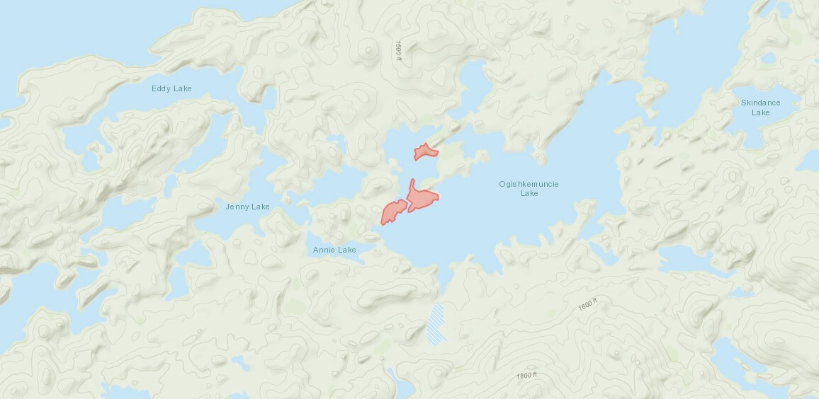
Summary: Late in the afternoon on June 13th, a wildfire was detected between Spice Lake and Ogishkemuncie Lake in the Boundary Waters Canoe Area Wilderness (BWCAW) on the Gunflint Ranger District of the Superior National Forest. Spice Lake is located east of Knife and Kekekabic Lakes and southwest of Seagull Lake, approximately 10 miles west of the Gunflint Trail.
Current Status: Fire activity was observed as creeping and smoldering in mixed timber and brush. Fire crews used indirect and direct tactics to get good fire line around the fire perimeter. They continued to strengthen the fire line perimeter working to keep the fire within the current footprint. Crews installed hose lines on several segments of the fire’s edge and are mopping up the fire’s edge. Mopping up involves putting water on the fire, and using tools to mix it into the soil and duff to extinguish the heat until the area is cooled.
In addition, firefighters successfully completed 3–4 acres of burning in the middle of the fire area to bring the fire line out to a natural barrier versus cutting fire line. Objectives continue to be mopping up along the fire perimeter. Firefighter and public safety are the number one priority.
Yesterday, fire investigators visited the fire area and made the initial determination that this fire was human caused and remains under investigation.
Planned Activity: Crews will continue to mop up the fire and work to extinguish hot spots and heavy fuel areas. A light helicopter has been assigned to the fire to support supply missions and for medivac purposes. A 30% chance of light rain and thunderstorms may pass over the fire area tomorrow, but precipitation amounts are expected to be very low. In addition, gusts and erratic winds may accompany the thunderstorms.
Closure Area: The Superior National Forest has implemented Forest Order (09-09-23-03) for a closure area of lakes, portages, and trails around the fire for public safety. Public safety crews have redirected visitors and posted portages closed. Details can be found at Superior National Forest - Alerts & Notices (usda.gov).
Fire Restrictions: The Superior National Forest has implemented a Forest Order (09-09-23-02) for campfire restrictions due to continued dry conditions and very high wildfire danger. This Order will remain in effect until further notice. See the Superior National Forest website https://www.fs.usda.gov/superior for more information on fire restrictions.
Cooperating Agencies: Gunflint Trail Volunteer Fire Department, National Park Service, and Minnesota Department of Natural Resources.
https://inciweb.nwcg.gov/incident-publication/mnsuf-spice-lake-fire/spice-lake-fire-facts-sheet-for-june-18-2023
Spice Lake Fire Fact Sheet
June 18, 2023 8:00am
MNICS Team B- Incident Commander Aaron Mielke
Fire Information: 218-248-7240 (8:00 a.m. to 9:00 p.m.)
Email: 2023.spicelake@firenet.gov
Inciweb: https://inciweb.nwcg.gov/incident-news/mnsuf-spice-lake-fire
Superior National Forest: www.fs.usda.gov/superior
Date Detected: 6/13/2023, Current Size: 22 acres, Containment: 65%
Summary: Late in the afternoon on June 13th, a wildfire was detected between Spice Lake and Ogishkemuncie Lake in the Boundary Waters Canoe Area Wilderness (BWCAW) on the Gunflint Ranger District of the Superior National Forest. Spice Lake is located east of Knife and Kekekabic Lakes and southwest of Seagull Lake, approximately 10 miles west of the Gunflint Trail.
Current Status: Fire activity was observed as creeping and smoldering in mixed timber and brush. Fire crews used indirect and direct tactics to get good fire line around the fire perimeter. They continued to strengthen the fire line perimeter working to keep the fire within the current footprint. Crews installed hose lines on several segments of the fire’s edge and are mopping up the fire’s edge. Mopping up involves putting water on the fire, and using tools to mix it into the soil and duff to extinguish the heat until the area is cooled.
In addition, firefighters successfully completed 3–4 acres of burning in the middle of the fire area to bring the fire line out to a natural barrier versus cutting fire line. Objectives continue to be mopping up along the fire perimeter. Firefighter and public safety are the number one priority.
Yesterday, fire investigators visited the fire area and made the initial determination that this fire was human caused and remains under investigation.
Planned Activity: Crews will continue to mop up the fire and work to extinguish hot spots and heavy fuel areas. A light helicopter has been assigned to the fire to support supply missions and for medivac purposes. A 30% chance of light rain and thunderstorms may pass over the fire area tomorrow, but precipitation amounts are expected to be very low. In addition, gusts and erratic winds may accompany the thunderstorms.
Closure Area: The Superior National Forest has implemented Forest Order (09-09-23-03) for a closure area of lakes, portages, and trails around the fire for public safety. Public safety crews have redirected visitors and posted portages closed. Details can be found at Superior National Forest - Alerts & Notices (usda.gov).
Fire Restrictions: The Superior National Forest has implemented a Forest Order (09-09-23-02) for campfire restrictions due to continued dry conditions and very high wildfire danger. This Order will remain in effect until further notice. See the Superior National Forest website https://www.fs.usda.gov/superior for more information on fire restrictions.
Cooperating Agencies: Gunflint Trail Volunteer Fire Department, National Park Service, and Minnesota Department of Natural Resources.
06/18/2023 09:07AM
toastedmarshmallow12: "Broad assumptions from a map that shows very little detail. Let's leave reporting to the firefighters. Your winds are inaccurate as well. They are north winds not south."
I’d like to point out everything I stated has been validated by reports from inciweb and/or the FS.
06/18/2023 11:18AM
jwmiller39: "toastedmarshmallow12: "Broad assumptions from a map that shows very little detail. Let's leave reporting to the firefighters. Your winds are inaccurate as well. They are north winds not south."
I’d like to point out everything I stated has been validated by reports from inciweb and/or the FS. "
A northwest wind blows southeasterly ......you are both correct!
It is time to move forward!

06/18/2023 03:23PM
We are out on Sag now. Had a great morning of lake trout fishing but got blown off the water around noon. The winds are really picking up, seems like they are out of the south/southeast. Sounds like they have the fire under control but hope this doesn’t cause too many issues for them.

Subscribe to Thread
Become a member of the bwca.com community to subscribe to thread and get email updates when new posts are added. Sign up Here
Community Links
 Search BWCA.com
 Donate
 Featured Sponsor
