|

Author
Text
")


11/13/2011 02:54PM
Planning a trip to WCPP from the Manitoba side. Coming into WCPP from Nopiming Provincial Park, in Manitoba. You Start at Berseford Lake and paddle into Garner Lake in the SouthWest corner of WCPP.
NEW MAPS ARRIVED YESTERDAY!!!
I got some new topo maps of WCPP, I now proudly own the whole park in topo maps, along with the regular WCPP Park Map of the portage's and lakes.
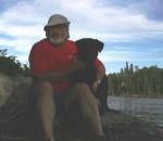
I Can't wait...and neither can Molly!!
SunCatcher
NEW MAPS ARRIVED YESTERDAY!!!
I got some new topo maps of WCPP, I now proudly own the whole park in topo maps, along with the regular WCPP Park Map of the portage's and lakes.
I Can't wait...and neither can Molly!!
SunCatcher

"WWJD"

11/15/2011 10:02AM
Not sure what routes I will travel this year up there. Maybe Leano all the way up to Lund? The guy I went with last year wants to fly in and paddle out. Pretty fun, marking up all them maps. Sunny, did you get the waypoints and tracks from Martin? He has some areas that are not on the park map. I did his "Minjim" route last year.
Nctry
12/13/2011 06:05PM
quote mocha: "i see Red Lake outfitters now offers an outpost cabin. wonder if that's a fly=in paddle out option?"
I think it is... I was going to fly in and paddle through Olive down to Linge and Young but the second leg of our trip was a no go due to the fire last year. So I'm putting in at Donald on June 1st and paddling out. Jerry is still looking for a bow partner as I'm paddling solo this time with my dog. I'd like to go back and try out the cabin a night or two then paddle out... A shorter trip that way.
Nctry
01/09/2012 01:35PM
FYI - Claire emailed me today "...the top end of the Irvine Loop and the NE end of the Royd to Murcoch passage will remain closed to visitors until such time as park staff have had a chance to visit and work on the portage trails in this area. The 750m portage from Murdoch to Larus is open."
LNT - The road to success is always under construction. http://hikingillinois.blogspot.com/
02/06/2012 07:40AM
Hey Paul....what scale maps did you get? I rec'd the canoe trail map from Doug Gilmore at the park, but I'm a little uncomfortable trying to navigate w/ that one....its so small. What did you use when you were up there last year? I guess I've gotten spoiled w/ the Fisher maps in BW/Quet.
..there is nothing- absolute nothing- half so much worth doing as simply messing about in boats - Wind in the Willows
Subscribe to Thread
Become a member of the bwca.com community to subscribe to thread and get email updates when new posts are added. Sign up Here
Community Links
 Search BWCA.com
 Donate
 Featured Sponsor