|
 Boundary Waters Quetico ForumWinter Camping and ActivitiesWinter Access Entry Points
|
Author
Text
")
12/18/2012 10:10AM
Ok, after scouring this thread (thank you TuscaroraBorealis): winter entry points I took all the information and compiled it in an easier to understand format. Please look it over and let me know what changes need to be made. Can it be easier to understand? Do you have additional information?
Also, when a point is designated with Plowed, that means there is automobile access but I have no idea what the parking situation is, unless noted.
Let me know what you think. Thanks.
______EDIT______2/12/2013
Alright, attached is an updated version of the list. It is in a PDF as well as Excel format. Let me know if you have further updates! Thanks much. PDF version
Excel Version
~Edited 2/12/2013 to reflect information about Mudro #23 and Ojibway #29 entry points.
~Edited 10/21/13 to reflect information from HO HO regarding some Echo Trail Entry Points. Thanks!
~Edited to include TuscaroraBorealis link to Current Snow Depths
"It is more important to live for the possibilities that lie ahead than to die in despair over what has been lost." -Barry Lopez
Reply
Reply with Quote
Print
Top
Bottom
Previous
Next

12/18/2012 10:34AM
Also, for EP 1, once the ice on Vermilion is thick enough you can just drive to the truck portage and park on the ice next to it, if either the snow isn't too deep or other people have packed it down enough. There's a teeny tiny parking lot halfway across the portage (at the wilderness boundary) where people park snowmobiles, but it'd be a bit silly to try to put a car there.


12/18/2012 11:09AM
quote Minnesotian: "
Ok, after scouring this thread (thank you TuscaroraBorealis): winter entry points I took all the information and compiled it in an easier to understand format. Please look it over and let me know what changes need to be made. Can it be easier to understand? Do you have additional information?
Also, when a point is designated with Plowed, that means there is automobile access but I have no idea what the parking situation is, unless noted.
Let me know what you think. Thanks.
"

Great job!
As stated, it would be nice if it could be in a larger format. Also, (once that is accomplished) I wonder if Adam or a moderator could make it a sticky post that always remains on top of this forum for easy/convenient future access.
12/18/2012 02:52PM
Is there a special way of adding the Excel sheet and a PDF to a message? Or do I just use the "add a photo to this message?"
And thanks for all the updates, especially the amount from Mocha. She sent in a lot of new information to add to the sheet.
"It is more important to live for the possibilities that lie ahead than to die in despair over what has been lost." -Barry Lopez
12/19/2012 10:24AM
quote motdur: "Nice!! Others, correct me if I'm wrong...Duncan #60 and Daniels #61 can also be accessed from the landing on Bearskin, off of Clearwater Rd."
I know you could easily access it from there. Just not sure if that parking area is kept open or not?
12/19/2012 08:15PM
quote TuscaroraBorealis: "quote motdur: "Nice!! Others, correct me if I'm wrong...Duncan #60 and Daniels #61 can also be accessed from the landing on Bearskin, off of Clearwater Rd."
I know you could easily access it from there. Just not sure if that parking area is kept open or not? "
Could have been one of those times they had time to plow, but it was open several years ago.
01/11/2013 07:34PM
Figured I add this resource for easy access. MN DNR snow depth and trail conditions
02/06/2013 04:17PM
Thanks for all the information!!! Of course the entry point that i was looking for was one of the only ones not listed.
MUDRO #23
Anyone know anything? Is it plowed all the way to where Chainsaw Sisters used to be?
Thanks in advance!!!
MUDRO #23
Anyone know anything? Is it plowed all the way to where Chainsaw Sisters used to be?
Thanks in advance!!!
"The word "adventure" is way overused. When everything goes wrong, that is when the real adventure begins" Yvonne Chouinard
02/07/2013 08:21AM
Ya, sorry about that. Looking at all the trip reports from members regarding entry point 23, not a single one of them was a winter report. If I were to venture a guess, I would say that it is not plowed. But, if you find otherwise, please let me know so that I can update the list.
"It is more important to live for the possibilities that lie ahead than to die in despair over what has been lost." -Barry Lopez
02/09/2013 03:32PM
I just got back from the Mudro access and the road was not plowed. High clearance four wheel drive vehicles have been back there and it may be possible if you have one. We were on snowmobiles and I suspect after the snow that is supposed to arrive tonight snowmobiles may be the only way in there. 

02/13/2013 09:37AM
Thanks for the update on Mudro. I've got a group of 4-5 that were planning on heading to Mudro, late Feb. I was wondering the same thing about the roads. We have a 4 wheel drive but I'll have to plan for a back up entry point if it's not drive-able. Still planning on it though!!
02/26/2013 05:43PM
Thanks for the pic, Zulu. That's the bridge over Picket Creek right at the Mudro EP, correct?
Edit: Doh. I see the EP sign on the right.
Looks like I miss a few neat things by not reading the Winter Camping forum...
Edit: Doh. I see the EP sign on the right.
Looks like I miss a few neat things by not reading the Winter Camping forum...
"You can observe a lot just by watching." -- Yogi Berra
02/26/2013 08:55PM
Grassy was plowed about 4 miles in almost to the place where you turn left. After that it is just a snowmobile trail. It may be possible to go further with 4wd and high clearance but if you get stuck it will be a big towing bill to get out.
10/21/2013 01:17PM
Nice work. I have some input on various Echo Trail EPs based on previous winters -
EP 6 Slim Lake - Plowed on North Arm Road. The EP is across the road (west) from the public access to the North Arm. The short drive to the EP is not plowed but if you can't drive it, you can park on the side of North Arm Road.
EP 7 From Big Lake - Plowed to public access on north side of Big Lake off Echo Trail.
EP 8 Moose River South - This EP is off the Moose Loop, which is not plowed. If you parked on the Echo Trail, you have to go 2-3 miles on the Moose Loop before you get to the EP (or to the Big Moose Trail).
EP 16 Moose River North - The road from the Echo Trail to the EP parking lot is not plowed, and if it is not passable, it's an extra half mile or so from the Echo Trail. You could try following the river from the Echo, but not sure you can get around the rapids to the EP. The Portage River is directly accessible from the Echo Trail.
EP 19 Stuart River - The EP is right next to the Echo Trail and when I've gone there the parking has been plowed too.
02/13/2014 01:41PM
quote Doughboy12: "How about clean this up and make it a "sticky" post?"
At one point it had been a sticky post. However, when I edit and update my original post, it unsticks as a sticky post and reverts to a regular thread. An occasional bump by me or interested parties works I think.
"It is more important to live for the possibilities that lie ahead than to die in despair over what has been lost." -Barry Lopez
09/01/2014 08:02PM
Last March I day skied around the Gabbro and Little Gabbro loop. There were vehicle tracks all the way to Nickel Lake, but they were old and I didn't want to risk getting stuck. Spruce Road was plowed past South Kawishiwi.
Also, last February we drove up amid a 12+ snowfall. Echo was one lane, not fully plowed when we parked at the Stuart River. We shoveled out a spot off to the side to park. While we were camping the plow came and plowed out the entire lot. Not sure if that's common or not? Little Indian Sioux is only plowed about 100ft off the Echo.
Also, last February we drove up amid a 12+ snowfall. Echo was one lane, not fully plowed when we parked at the Stuart River. We shoveled out a spot off to the side to park. While we were camping the plow came and plowed out the entire lot. Not sure if that's common or not? Little Indian Sioux is only plowed about 100ft off the Echo.
10/10/2014 10:31AM
quote Bearpaulsen: "Last March I day skied around the Gabbro and Little Gabbro loop. There were vehicle tracks all the way to Nickel Lake, but they were old and I didn't want to risk getting stuck. Spruce Road was plowed past South Kawishiwi.
Also, last February we drove up amid a 12+ snowfall. Echo was one lane, not fully plowed when we parked at the Stuart River. We shoveled out a spot off to the side to park. While we were camping the plow came and plowed out the entire lot. Not sure if that's common or not? Little Indian Sioux is only plowed about 100ft off the Echo.
"
Thanks for that information, and also welcome to the site. Have really enjoyed your winter classes at Midwest and am glad you are bringing that knowledge here.
"It is more important to live for the possibilities that lie ahead than to die in despair over what has been lost." -Barry Lopez
10/10/2014 02:02PM
quote Bearpaulsen: "Also, last February we drove up amid a 12+ snowfall. Echo was one lane, not fully plowed when we parked at the Stuart River. We shoveled out a spot off to the side to park. While we were camping the plow came and plowed out the entire lot. Not sure if that's common or not? Little Indian Sioux is only plowed about 100ft off the Echo."
In my experience, they plow the parking lots at Hegman, Angleworm, and Stuart River, also the public access at Big Lake, but not Moose River North (haven't looked at LIS North). That's not based on a huge sample but several times through there through the years in winter.
03/12/2015 01:20PM
Just wanted to add some information from a recent trip.
South Lake can be accessed from Mayhew Lake Road. The entrance to this road was plowed out and provided parking for at least 6 vehicles. While the remainder of the road was not plowed, there appeared to be sufficient (snowmobile?) traffic to keep a trail open to the north end of Mayhew Lake. From there the trail narrows to that of a typical portage/hiking trail.
South Lake can be accessed from Mayhew Lake Road. The entrance to this road was plowed out and provided parking for at least 6 vehicles. While the remainder of the road was not plowed, there appeared to be sufficient (snowmobile?) traffic to keep a trail open to the north end of Mayhew Lake. From there the trail narrows to that of a typical portage/hiking trail.
03/12/2015 01:55PM
quote TuscaroraBorealis: "Just wanted to add some information from a recent trip.
South Lake can be accessed from Mayhew Lake Road. The entrance to this road was plowed out and provided parking for at least 6 vehicles. While the remainder of the road was not plowed, there appeared to be sufficient (snowmobile?) traffic to keep a trail open to the north end of Mayhew Lake. From there the trail narrows to that of a typical portage/hiking trail. "
Just remember the portage down to south from topper is absolutely brutal. I couldn't imagine taking a sled full of gear down there or getting it back out. But a base camp on topper with a day trip to south would be very doable.
12/02/2016 11:16AM
I'd like to suggest adding EP 79 - Eagle Mountain to the list. It's never included in BWCA.com I guess because it's not a canoe entry, but for winter it's an excellent day or multi-day trip up the mightiest peak in Minnesota!. Parking lot is plowed, and trail well used all winter.
12/26/2016 09:12PM
quote Ho Ho: "LI North is not ever plowed. If you want access to Indian Sioux North take the portage trail along the river from the LIS parking lot.quote Bearpaulsen: "Also, last February we drove up amid a 12+ snowfall. Echo was one lane, not fully plowed when we parked at the Stuart River. We shoveled out a spot off to the side to park. While we were camping the plow came and plowed out the entire lot. Not sure if that's common or not? Little Indian Sioux is only plowed about 100ft off the Echo."
In my experience, they plow the parking lots at Hegman, Angleworm, and Stuart River, also the public access at Big Lake, but not Moose River North (haven't looked at LIS North). That's not based on a huge sample but several times through there through the years in winter.
"
11/20/2017 06:39PM
Well, after seeing Bear Paulsen at Midwest Mtn. this past weekend, whooooo boy, did he have a pile of winter entry point info. I was writing as fast as I could, but I know I missed a lot. Still, i'll see if I can update the spreadsheet sometime soon with all his info. Thanks Bear!
"It is more important to live for the possibilities that lie ahead than to die in despair over what has been lost." -Barry Lopez
01/12/2018 06:38PM
Hi Minnesotian. I just found this thread after having posted something earlier today on the Trip Planning forum. I wasn't aware of the "Winter Camping and Activities" forum. Is there any way that you could provide some current information regarding EP 84 (Snake River) and EP 33 (Little Gabbro)? I want to get into Bald Eagle Lake. Following is what I posted earlier today on the Trip Planning forum. Thank you!!
I need advice / help / guidance, please!
I'm wanting to do a 1 or 2-day trip into Bald Eagle Lake here in a few weeks. Originally, I was planning to go into Entry Point 33 (Little Gabbro) via Spruce Road. However, the Lake County Hwy Dept informed me that Spruce Rd is only plowed up to Entry Point 32 (Kawishiwi River / Filson Creek). So, I don't know if Spruce Rd will be drive-able to EP 33 with a 4x4 pickup or if I could find someone to plow a path for me (without it costing an arm and a leg).
Another option that I'm considering is Entry Point 84 (Snake River). This EP is MUCH closer to Bald Eagle, but there are two big unknowns for me:
1) Is the road to EP 84 plowed / accessible?
2) Is the Snake River safe to walk on during the winter? I know that it has been extremely cold there for quite a while lately (-30 temps sustained for weeks and only recently came up a little).
Anyone who can provide some experienced knowledge here would be extremely appreciated. I leave in a few weeks. Thanks in advance!!
01/22/2018 02:49PM
scottschaeffer: "Hi Minnesotian. I just found this thread after having posted something earlier today on the Trip Planning forum. I wasn't aware of the "Winter Camping and Activities" forum. Is there any way that you could provide some current information regarding EP 84 (Snake River) and EP 33 (Little Gabbro)? I want to get into Bald Eagle Lake. Following is what I posted earlier today on the Trip Planning forum. Thank you!!
Heyo Scott,
Sorry I didn't see this post earlier. Here is the link to a recent discussion about Entry Point 32 and 33 that might help you: Little Gabbro access
"It is more important to live for the possibilities that lie ahead than to die in despair over what has been lost." -Barry Lopez
")
01/22/2018 09:48PM
From the Kawishiwi entry point I have parked numerous times(like 10 years ago I use to go there quite often,so info is old, but I bet still relevant) and skiied on usually a packed trail from snowmobiles or dog sleds up to the Little Gabbro entry point. Usually it is used by various groups so portage should be well packed?
Read my comments on how to get to Gabbro via swamp and Bald Eagle by going around the rapids from Bald Eagle-that could be very dangerous by going along rapids. Link provided previous post.
I have day skiied from The Kawishiwi parking lot to Bald Eagle- Pietro and back in March before.
I think the Snake entry point would be one heck of a challenge and probably thin ice on the Snake. My opinion,I wouldn't go that way. Also you have miles of unplowed roads getting there unless there logging.
I am sure like Wintergreen or one of the others runs Dog sleds that way to Little Gabbro.
If you have Questions just ask and I am sure their must be others who used the trail recently.
10/01/2019 07:32AM
tonyyarusso: "OP's DropBox links seem to be dead now - does anyone have the most recent versions to re-upload somewhere else?"
Heyo, just saw this message. Here is the updated links to the information:
PDF Link
Excel Link
"It is more important to live for the possibilities that lie ahead than to die in despair over what has been lost." -Barry Lopez
12/24/2019 11:56AM
Shows Sawbill trail is plowed. Does anyone know if the public parking lot at the end of Sawbill trail is plowed ? If not is there any acceptable parking location at the end of the trail for overnight tripping ? Thanks
12/31/2019 11:14AM
Hey everyone,
So, in order to make the Winter Access document more dynamic, I am starting to link the discussion threads pertaining directly to the entry point in question into the document. This is in the Excel Version only.
To access the discussion thread in the Excel Version, open the Excel document, look to the right side of the Entry # to find the link, and then hold down Ctrl on the keyboard and then click the link.
So far I have linked the discussion about Mudro access, but I will update as I see more.
Also, I have added a "Last Update" date at the top of the page.
Excel Version Winter Access Entry Points
"It is more important to live for the possibilities that lie ahead than to die in despair over what has been lost." -Barry Lopez
01/03/2020 04:55PM
Dolpho: "Shows Sawbill trail is plowed. Does anyone know if the public parking lot at the end of Sawbill trail is plowed ? If not is there any acceptable parking location at the end of the trail for overnight tripping ? Thanks "
I do know that when I've been there (both January of 2018 and 2019) the parking lot was plowed but I'm not sure if that is the norm or if it coordinated ahead of the MN Frozen Butt Hang(hammock) winter trip to Sawbill.
02/15/2020 03:17PM
Here's a look at most of the winter parking options for Gunflint Trail BWCAW entry points. The entry points are time stamped in the description.
Gunflint Trail Winter Parking
Gunflint Trail Winter Parking
02/18/2020 04:49PM
Tuscarora Outfitters: "Here's a look at most of the winter parking options for Gunflint Trail BWCAW entry points. The entry points are time stamped in the description.
Gunflint Trail Winter Parking "
Great intel...thanks so much for this. Good to see conditions from your POV.
Mucho appreciato~~~~
Shug
Whoooooooo Buddy))))))
10/24/2020 12:30PM
Minnesotian: "
Hey everyone,
So, in order to make the Winter Access document more dynamic, I am starting to link the discussion threads pertaining directly to the entry point in question into the document. This is in the Excel Version only.
To access the discussion thread in the Excel Version, open the Excel document, look to the right side of the Entry # to find the link, and then hold down Ctrl on the keyboard and then click the link.
So far I have linked the discussion about Mudro access, but I will update as I see more.
Also, I have added a "Last Update" date at the top of the page.
Excel Version Winter Access Entry Points "
Hi everyone,
Just letting you all know that this link is still active, I just checked it this morning. Happy planning.
"It is more important to live for the possibilities that lie ahead than to die in despair over what has been lost." -Barry Lopez
11/15/2020 11:34AM
Minnesotian
Hi everyone,
Just letting you all know that this link is still active, I just checked it this morning. Happy planning.
Hi. Just letting you know that this link is still performing a great public service, I just used it this morning. Thanks!
11/18/2020 01:43PM
Tomahawk Road/FR 377 is currently compacted and driveable all the way to EP 35 (Isabella Lake)/EP 86 (Pow Wow Trail). Given the weather forecast, it’s likely to remain passable, but soften some. There were vehicle tracks at the roads to Snake River and Boga Lake.
12/02/2020 11:06PM
Just wanted to express my thanks for putting this list together and maintaining it. I use it when I take friends up to go winter backpacking and it definitely saved us last year. Since I'm often taking new people, it helps to have a solid, reliable entry point that's plowed so everyone can feel comfortable, and this list is invaluable.
Cheers, keep on exploring.
Cheers, keep on exploring.
12/05/2020 10:16PM
Thanks PaytonFrost,
I am glad the list is helpful. It wouldn't be possible without the help of many contributors. Thanks much to all!
---And just to let you all know, it has been updated with a link to Tuscarora Lodge's video from last winter, a discussion about South Kawishiwi access, and other tidbits.
Winter Access Entry Points Excel version
"It is more important to live for the possibilities that lie ahead than to die in despair over what has been lost." -Barry Lopez

12/21/2022 08:09AM
Hello everyone. It is that time of year again when people are starting to ask about where to go/park in the BWCA. So, I updated the Excel list again, making sure the links all work. Reminder to hold down CTRL on the keyboard as you click the link in the document to access the hyperlink.
Winter Access Entry Points Excel Version
As always, let me know in this thread if you know of current information that can be added to the list.
Also, here are some great websites to know the snow depth around the area and some other snow related things:
The last 24, 48, 72 hour snowfall accumulation
Snow Depth Specifically for the BWCA/North Shore
Rutgers University global snowcover
Iowa State University Days since last Blizzard Warning
MnDNR Snow Depth and Groomed Trails Conditions
"It is more important to live for the possibilities that lie ahead than to die in despair over what has been lost." -Barry Lopez
04/15/2023 04:41PM
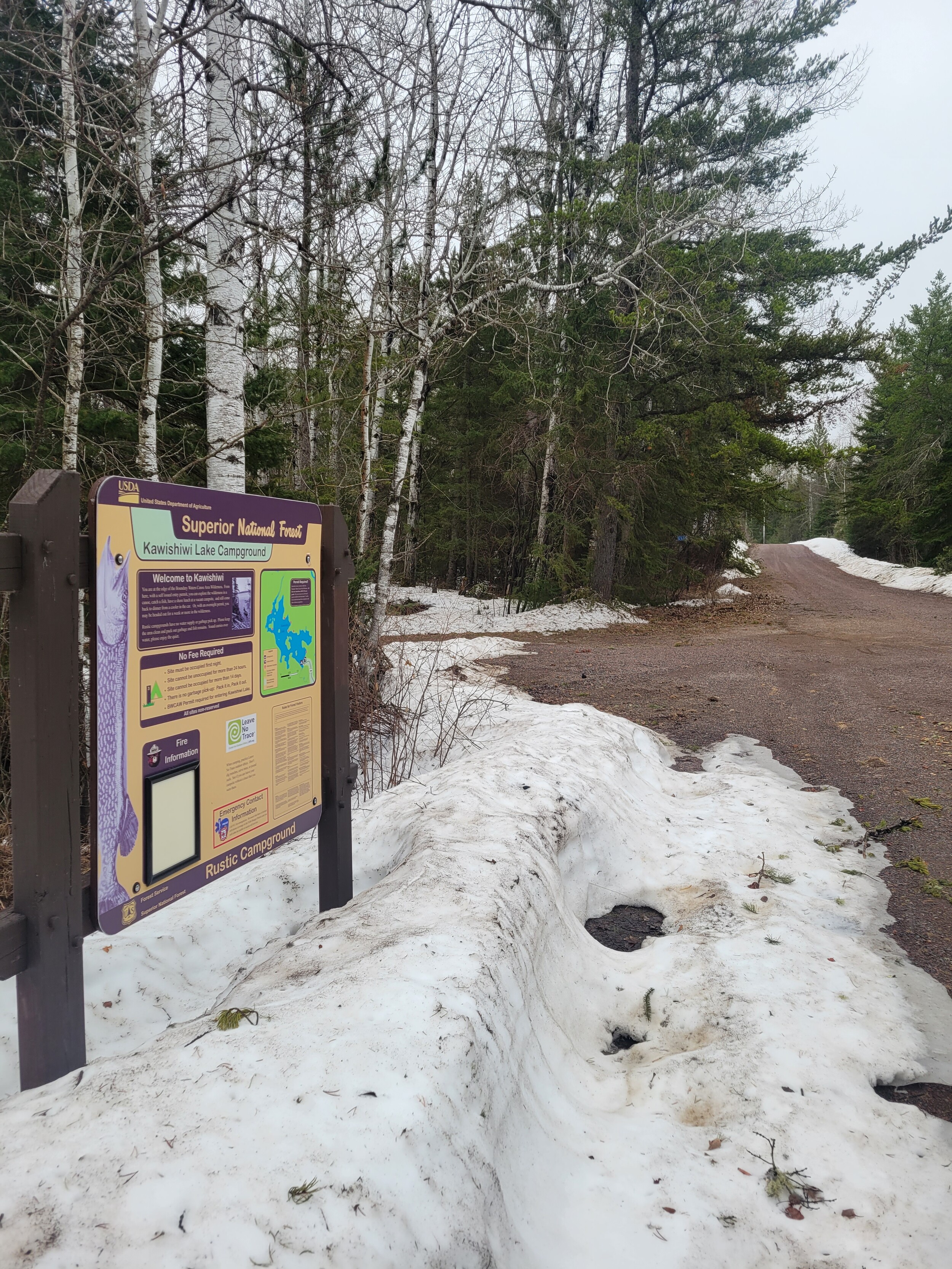
So, I made it to Kawishiwi Lake EP #37 earlier today. While I believe county road 7 is always maintained, I have always been under the impression (as the spreadsheet also states) that this spur road is not routinely plowed. Yet the road was completely open with clearly plowed snowbanks all the way up to the campground and appears to have taken plce throughout the winter. The adjoining parking lot was plowed too! Not sure if this is the new normal or was just a one (this) year phenomenon or special circumstance? 


Reply
Reply with Quote
Print
Top
Bottom
Previous
Next
Subscribe to Thread
Become a member of the bwca.com community to subscribe to thread and get email updates when new posts are added. Sign up Here
Community Links
 Search BWCA.com
 Donate
 Featured Sponsor