|
 Boundary Waters Quetico ForumGroup Forum: Woodland Caribou Provincial ParkOpasquia Provincial Park
|
Author
Text
")

10/12/2013 08:12AM
Last year Farmer and I paddled this park for two weeks. We used Big Hook Wilderness Camps to do the trip. http://www.bighookcamps.com/index.html Big Hook Wilderness Camps
The trip journal, G4 map and you tube video can be found here:
https://sites.google.com/site/thenorthwoodsman1/
Marten's Blog
In 2014 the cost will be around $650 each for the round trip flights. Canoe rental will be $55 per day per canoe. All trips are Saturday to Saturday from Red Lake, Ontario. Canoe rental package includes a gallon of white gas or a propane canister for each week, tent, paddles and life jackets. Renting the tent (accomodation) from the outfitter waives the need for Ontario Crown Land Camping permits which are normally required in the non-operating Ontario Provincial Park. They have two Nova Craft 17 Prospector canoes in Royalex and a Dagger Legend 15 in Royalex. The Legend has 3 seats but I put some packs in it last year and found it to make a really good solo canoe.
https://www.youtube.com/user/TheNorthwoodsman1
10/12/2013 11:41AM
Just some additional tidbits that you would likely find elsewhere that you would probably wish to know about.
Flights are from Red Lake, Ontario to Central (Big Hook) Lake in Opasquia PP. The flight is in 2 stages: Commercial carrier (Wasaya) from Red Lake to Sandy Lake and float plane from Sandy Lake to Central Lake. This is important because you will not be able to transport your own canoe unless you have something like a PakCanoe that can be loaded as baggage on the commercial leg of the flight. In addition, there is a weight restriction of 100 pounds for the (commercial) flight and you will pay by the pound for overage. (If the overage is significant, there is no guarantee it will be on the same flight that you are on.)
Presently, all canoe trips begin and end at Central Lake. At present, all "loopable" routes will take you west from Central Lake.
Big Hook Wilderness Camps operates about a half-dozen remote fishing camps spread through out the park (a couple of those are technically outside park boundaries). This does mean that you'd likely hear float plane traffic during Saturday change-out at the cabins. In addition, this area is actively used by the First Nation for hunting and fishing. Thus, there are a number of seasonal use F/N "cabins" scattered around the park along with the occasional boat cache.
As far as I know, the best available map information is represented by the G4 map on the website link in Marten's post.
Lastly, 2 of the 3 canoes are already spoken for for 2 weeks next year during the late June/early July window. :-)
dd
"If you can keep your head when all about you are losing theirs" chances are you missed something. (Inspired by Rudyard Kipling.)

10/13/2013 05:28PM
For some of you, the area of Opasquia Provincial Park may not be all that familiar. The map below roughly covers the park. I've added the route that Marten took on his trip (red dashed lines) and routes that have been documented by other sources (red dotted lines). In addition, I've added notations for the locations of cabins operated by Big Hook Outfitters within the park. (Note: The cabin on Burnt Lake is not technically inside park boundaries.) Marten (and I) believe that there are potentially two additional linkages--Mossberry to Joint Lake and Southwest to Indian Lake that could add 2 additional loop possibilities to the park. (Indian Lake is not marked on this map, but lies just to the east of Tulibee Lake.) In addition, there is a historical route that would take you to Island Lake, MB (large lake in the NW corner of the map) that would connect from Cocos Lake and thru Hilton Lake. However, this would involve at least one day's camping in Manitoba and would be substantially outside the boundaries of OPP.
dd

dd

"If you can keep your head when all about you are losing theirs" chances are you missed something. (Inspired by Rudyard Kipling.)

10/29/2013 11:07PM
Got an e-mail response to a series of questions I previously sent to BHWC. Here are Q's and A's.
Question 1: What kind of tents do you have available?
Answer: We plan on buying 2 new tents for the 2014 season. We have been in the flyin outpost business for 30 years, but never really pursued the canoe biz until talking to Martin. We have 1 good tent up there now, but don't know the make. One thing to remember is, there is the 100 pound weight restriction.
Question 2: A number of our group are reasonably committed hammock campers. Is it acceptable to leave the rented tent(s) behind and actually use other forms of "sleeping accommodation?" It is understood that we'd need to find appropriate trees (and all use tree straps rather than ropes to minimize impact on the trees) or "ground" the hammock (which is another option).
Answer: If you want to use hammocks that is your option.
Question 3: While I suspect we'll be using white gas stoves, one of our party might consider taking a JetBoil-type stove.
Answer: The canisters for this stove use a different thread arrangement than the "Coleman" style. What kind of "bottle" did you plan on stocking? Standard off the shelf Coleman bottles from Walmart.
Question 4: Does the gallon of white gas come in its own (metal) can or should we plan to bring sufficient fuel bottles to transfer that volume to?
Answer: Metal cans
Question 5: Other than issues that might arise with air transport, any issues with us supplying our own PFD's and paddles? One of our number is a newbie and will likely need what you supply. The balance of our crew are old hands (literally) and have selected paddling gear for personal comfort and fit. I'm sure we'd take one of your paddles per canoe as backup.
Answer: No problem. Watch the weight.
Question 6: Martin mentioned in his write up of his trip that you put him up for the last night of his trip. I'm assuming this arrangement was made to facilitate early morning departure and is done on a space available basis?
Answer: Be back at Central on Friday night. We start fly at daybreak. If the small cabin is available you may use it. We have a shower and a sauna, and you are welcome to use them.
Question 7: Can we individually pre-pay for our trip?
Answer: Yes. Lots of groups pre pay.
dd
"If you can keep your head when all about you are losing theirs" chances are you missed something. (Inspired by Rudyard Kipling.)
05/30/2014 08:20PM
quote dentondoc: "Question 1: What kind of tents do you have available?
Answer: We plan on buying 2 new tents for the 2014 season. We have been in the flyin outpost business for 30 years, but never really pursued the canoe biz until talking to Martin. We have 1 good tent up there now, but don't know the make. One thing to remember is, there is the 100 pound weight restriction. "
Update: The tent currently available at Big Hook is a Eureka Apex 2 (fiberglass pole version). It was only used on one 2-week trip prior to this season. No new tents have been purchased as of last Saturday.
dd
"If you can keep your head when all about you are losing theirs" chances are you missed something. (Inspired by Rudyard Kipling.)
07/10/2014 09:19PM
Just thought I'd add a little to the previous discussion about OPP, having completed a 2-week trip there this past weekend.
Here is a map that provides an overview of our route.

Our route started on the east side of the park at Central Lake and proceeded in a northwesterly direction to our most western point on Joint Lake. We then headed south to Cocos Lake before completing our western loop and retraced our steps back to Central Lake.
Here are a few observations about this route (note circled areas on the map).
There are 3 portage and a chute between Central Lake and East Lake. The chute is runnable heading down stream (flow is out of Central toward the west). However, you will be unlikely to paddle it going up stream. We lined along the shore on our return trip.
The next spot that contains a chute might be iffy to run in high water, but there is no developed portage here. We found a likely landing spot and more or less bushwhacked our way to the far side of the chute ... approximately 15 rods. (At this stage of our trip, we were unsure about how our return route would develop so we wanted to make sure that we could get back past the chute area should it become necessary. It didn't appear that we could have lined this stretch due to water level.
On Joint Lake, our intent was to do a bit of investigating as to the feasibility of making a large loop from Joint through Mossberry and then back to the extreme northwestern tip of East Lake. (You might recall from Marten's report that he and Farmer investigated a portage out of East Lake in the direction of Mossberry). We did detect (and walk) a track through the woods from Joint Lake to a pond about 3/4 the way across to Mossberry ... about 266 rods. This track appeared most likely to have been used by snow machine, but it was easily followed once you broke beyond the alder choked shoreline. We also detected a possible spur trail that would head around the western side of the pond, but it was comparatively overgrown. (Pre-trip, an examination of satellite images appears to show a track leaving the pond at about the 11 o'clock position and heading in a more or less straight light to Mossberry). Thus, it seems likely that a loop could be completed in this northwestern section of the park.
On Joint Lake, we also checked out the portage out of the north side that bypasses a series of rapids and places you in the river that soon dumps you into Island Lake, MB. This portage looked to receive substantial use by the First Nation to drag aluminum boats around the un-navigable waters of the rapids.
Although not circled on this map, I should mention that as we approached our entry into Cocos Lake we had to navigate through a set of falls with an island in the middle. From Marten's report, it appears that there was a portage on the western side of this set of falls that he used. I've also found indications elsewhere that there is a portage on the east side of the falls. Perhaps it was water level or perhaps the portage entrances were more difficult to detect going upstream, we used neither. We did a very short portage OVER the island and then briefly line out beyond fast moving water to continue our paddle on into Cocos Lake.
Finally, as we existed the Cocos Lake area and before completing out western loop, I'd seen references to a short portage across a narrow neck of land that would put you back on the far western end of East Lake, thereby avoiding a portage and the aforementioned chute/bushwhack. The portage (approximately 25 rods) does exist, although it has fallen into disuse. There were numerous dead falls to negotiate and even spots where the track disappeared under substantial deadfall. One section we walked appeared to be more moose track than portage, but at least it put us back on the actual portage track. Thus this portage, provides a bit of a shortcut and eliminates retracing some of the route at the eastern end of our loop.
For those that might be interested in other details about this trip, I'd be happy to convey whatever information I gleaned on this trip.
dd
"If you can keep your head when all about you are losing theirs" chances are you missed something. (Inspired by Rudyard Kipling.)
07/11/2014 01:46AM
At Canoecopia this spring I asked the folks from the Ontario Parks Dept about if you rented some gear [tent in pactiular] from an outfitter would you still need Crown permits.
They told me that used to be the rule but due to the difficulty in enforcing it they had dropped the rule, even if you outfit from an outfitter if you camp on Crown Land you need a permit. I thought that I could save some money. FRED
They told me that used to be the rule but due to the difficulty in enforcing it they had dropped the rule, even if you outfit from an outfitter if you camp on Crown Land you need a permit. I thought that I could save some money. FRED
Grant me the senility to forget the people I never liked, the good fourtune to remember the ones do, and the eyesight to tell the differance.
07/11/2014 08:41AM
quote FOG51: "At Canoecopia this spring I asked the folks from the Ontario Parks Dept about if you rented some gear [tent in pactiular] from an outfitter would you still need Crown permits.
They told me that used to be the rule but due to the difficulty in enforcing it they had dropped the rule, even if you outfit from an outfitter if you camp on Crown Land you need a permit. I thought that I could save some money. FRED"
Apparently the rule change is not taking root very well in the OPP area.
We did use Big Hook Wilderness Camps as our outfitter and they did supply a "package" that included canoe, tent and fuel ($50 per day with one gallon of fuel per week). We chose not to use their tent. We were told by several sources (beyond the outfitter) that a rented tent constituted "lodging" and consequently the daily Crown Land camping permit was waived. I really don't think it mattered much one way or the other since we had no human contact (or sightings) between the time we left our Central Lake starting point until we returned 14 days later.
dd
"If you can keep your head when all about you are losing theirs" chances are you missed something. (Inspired by Rudyard Kipling.)
07/12/2014 12:07PM
quote dentondoc: "Just thought I'd add a little to the previous discussion about OPP, having completed a 2-week trip there this past weekend.
Although not circled on this map, I should mention that as we approached our entry into Cocos Lake we had to navigate through a set of falls with an island in the middle. From Marten's report, it appears that there was a portage on the western side of this set of falls that he used. I've also found indications elsewhere that there is a portage on the east side of the falls. Perhaps it was water level or perhaps the portage entrances were more difficult to detect going upstream, we used neither. We did a very short portage OVER the island and then briefly line out beyond fast moving water to continue our paddle on into Cocos Lake.
dd"
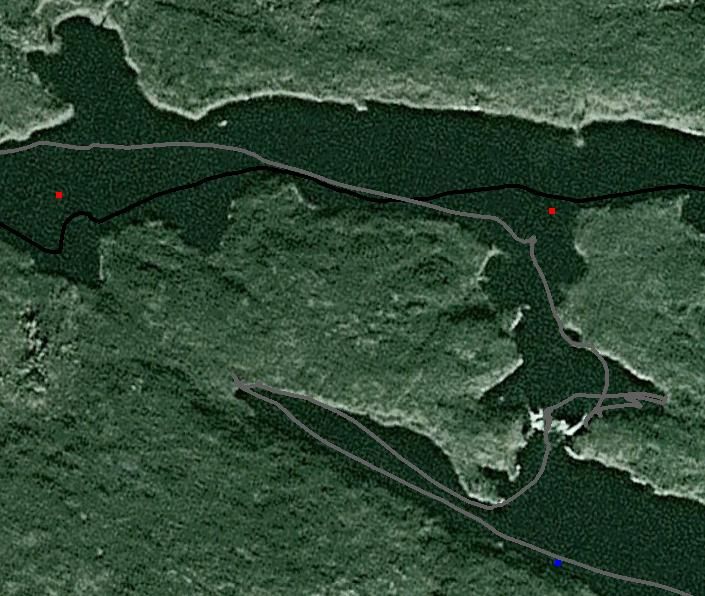
I investigated another possible way around these rapids. After I finished the island portage dd mentioned I went to the end of a small cove South and west of the rapids. I found a trail and followed it about 15 ft. It looked like several of the lesser used portages we saw. In other than cold water season I would still do the island portage. I would suspect that the first nation people motor up and down these rapids. The gray line on the following picture is my GPS tracks superimposed on a google image.
The question of the day is Freedom or Socialism?? MagicPaddler
07/12/2014 06:11PM
Farmer and I were going downstream into Cocos Lake. I checked out the rapids on the north side of the island and found them to be dry. I noted that this passage could be used to portage if traveling upstream. We were there in very low water conditions. Since we had witnessed a motorboat go down the chute on the other side of the island we went ahead and shot the chute. We then witnessed a motorboat head up the chute against the current. Big Hook Wilderness Camps has a lot of info that can be gleaned from their website. Big Hook Wilderness Camps
You can go to the info for the different outpost cabins and see a topo map and an interactive Google map. On the interactive map you will see directions on how to navigate up this chute with a motorboat. That is probably why any portage in the area is going to see very little use.
You can go to the info for the different outpost cabins and see a topo map and an interactive Google map. On the interactive map you will see directions on how to navigate up this chute with a motorboat. That is probably why any portage in the area is going to see very little use.
https://www.youtube.com/user/TheNorthwoodsman1
07/12/2014 06:58PM
Martin
I was referring to the swift water between Joint and Cocos. I believe you are referring to the swift water near the cabin on Cocos. We went up that one using information you supplies.
MagicPaddler
I was referring to the swift water between Joint and Cocos. I believe you are referring to the swift water near the cabin on Cocos. We went up that one using information you supplies.
MagicPaddler
The question of the day is Freedom or Socialism?? MagicPaddler
07/13/2014 06:22AM
I missed that completely. I did not realize you were referring to the rapids out of Cocos to the north. In that spot we did find a portage on river left. The portage we used on river left was OK until you had to get back in the water. It was a steep face in fast water and we were there in low water conditions. Paddling upstream in high water you would not have even imagined it was a portage landing. We saw evidence that some boats had been dragged up river left through the rapids. We had checked out the forest on river right and it would have been possible to bushwhack there also. No defined trail but evidence of some use.
https://www.youtube.com/user/TheNorthwoodsman1
07/13/2014 08:52AM
quote Marten: "I missed that completely. I did not realize you were referring to the rapids out of Cocos to the north. In that spot we did find a portage on river left. The portage we used on river left was OK until you had to get back in the water. It was a steep face in fast water and we were there in low water conditions. Paddling upstream in high water you would not have even imagined it was a portage landing. We saw evidence that some boats had been dragged up river left through the rapids. We had checked out the forest on river right and it would have been possible to bushwhack there also. No defined trail but evidence of some use. "
Yes, we thought that the river left shore looked like a possibility, but going upstream into fast moving water and then scrambling up a rock face appeared to be more risk than we wanted to face. In addition MP was traveling solo and even if our tandem arrangement could have made it to the takeout spot, a solo attempt looked like an excellent opportunity to dump.

Our solution was to pull in behind the island that set astride of the two outflows. There was a reasonable take-out spot in essentially still water behind the island toward the river left side. We unloaded canoes there, one at a time, and did a short two-man carry to the upstream side of the island, where the water was shallow and had little comparative current. Then after loading, we maneuvered (lined) our canoes out away from the rocky shallows to a spot with slight downstream current. The paddle away from that spot was quite easy.
I wish we had not been so quite so focused on getting beyond the rapids at that spot. It was a beautiful area, topped off by being within sight of an active Bald Eagle nest, which likely means the fishing would have been outstanding there also. However, our fishing gear had been stored for travel, and we still had to tackle the open water of Cocos Lake on our way to our planned stopping point for the night (just beyond the other moving water/chute, you mentioned above). Even moving on, we ultimately faced a significant breeze in our face before the finished paddling for the day ... a long paddle in rolling surf with few islands or other points of land to produce a wind shadow.

Our traverse of the "in-flow" into Cocos Lake also presented a few challenges. As we entered the narrows before the chute, we were faced with a reasonably stiff current. Even in a tandem, we were expending a lot of energy to get into an area where we weren't immediately drifting backwards when we weren't digging reasonably hard. MP, on the other hand, had to line past this area ... just too much current to paddle against as a solo. Then the "rock garden" portage (absolutely no way to line around the chute and no evidence of a portage) even had a bit of water running through it. So, we unloaded and did another 2-man lift, drag, float (repeat) traverse through that spot. There was a bit of a trail (of sorts) on the river right side of this passage that we were able to transport our gear over but was too tight for the canoes.
dd
"If you can keep your head when all about you are losing theirs" chances are you missed something. (Inspired by Rudyard Kipling.)
07/13/2014 09:19AM
dd"
I wish we had not been so quite so focused on getting beyond the rapids at that spot. It was a beautiful area, topped off by being within sight of an active Bald Eagle nest (which likely means the fishing would have been outstanding there also).
dd"
I know what you mean. We had passing rain squalls on a cold day and took an extended lunch break at the upstream portage landing. It was a fantastic place to spend some time.
https://www.youtube.com/user/TheNorthwoodsman1
07/15/2014 06:50PM
I have posted trip report.
The question of the day is Freedom or Socialism?? MagicPaddler

Subscribe to Thread
Become a member of the bwca.com community to subscribe to thread and get email updates when new posts are added. Sign up Here
Community Links
 Search BWCA.com
 Donate
 Featured Sponsor