BWCA Entry Point, Route, and Trip Report Blog
April 27 2024
Entry Point 52 - Brant Lake

Number of Permits per Day: 4
Elevation: 1500 feet
Latitude: 48.0692
Longitude: -90.8455
Brant to Tuscarora via Little Sag Route:
Round
Brant
Bat - Mud
Gillis - burn area is evident:
French
Peter - first lake trout:

Virgin
Little Sag - green trees again!
Mora - gorgeous divide of burn and green
Crooked
Owl
Tuscarora - second lake trout!
Missing Link - with lighter food pack, the portage is OK
Round
Boundary Waters trip report, Entry point #52 - Brant Lake
Entry Date:
August 19, 2014
Entry Point:
Brant Lake
Number of Days:
8
Group Size:
2
A little background; I am going on 60 years old, my wife is 57. We have been making canoe trips to the Boundary Waters over the past 15 years and have been to a large portion of the canoe area, including one trip up into Quetico. We both exercise regularly, besides bicycling, kayaking, and camping. We each have a large Cabela’s Boundary Waters waterproof backpack with shoulder straps and waist belt and small day packs. We use an insulated Boundary Waters food pack with shoulder straps and waist belt plus a smaller Duluth pack for dry food goods. We packed enough good food for a one week trip. I also packed 2 fishing poles and a few fishing accessories.
I selected Entry point #52 – Brant Lake in order to paddle into Little Saganaga and Gabimichigami lakes. We have not been to these lakes and I had researched and mapped out lakes which were know to have lake trout. A special thanks to Stew Osthoff and Bill Colgate for the Lake Trout article in the Spring 2014 Boundary Waters Journal. We decided to take the southern route into Little Sag after reading about the blow down and forest fires that passed through the area a few years back. Thanks to Gyrfa’s 2005 trip report. We only needed the #7 Tuscarora McKenzie map for this trip.
Tuesday, August 19, 2014 we made the 8 hour drive from home (south of Green Bay, WI) to Grand Marais. We checked in at the Grand Marais Ranger Station in order to pick up our entry permit. The Forest Ranger was very friendly and helpful as we discussed our route. She had a few suggestions for camp sites and fishing along the way. That night we stayed at the Lutsen Lodge, overlooking Lake Superior . We enjoyed a fine dinner, a stop in the pub, a walk along the trails, and nice beach area before retiring for the night and listening to the waves roll in.
Wednesday, August 20. We got an early start and headed to Grand Marais. Had a great breakfast , with plenty of coffee, for a reasonable price at the South of the Boarder Café in Grand Marais. The weather was cool and cloudy but no rain. We made the 40 mile drive up Gunflint trail and found the Round Lake canoe launch and parking area. Unloaded all our gear and canoe and shoved off at 10 am. As we were paddling across Round Lake we saw a canoe come out of the portage. We then realized it was not the portage we wanted into West Round Lake but was a 142 rod portage into Missing Link lake. These two portages are not too far apart. The GPS and map got us back on track. There was a large beaver dam just off of Round Lake which caused high water level into West Round Lake. The portage trail was under a good 12 inches of water for most of the 77 rods. There were multiple sections of double planks floating in some portage sections. Made for a tricky first portage. NOTE: coming back later in the week I do believe you can put in your canoe right at the beaver dam and canoe the creek into West Round Lake due to the high water level and save the hassle of the underwater portage trail).
(picture) Flooded portage trail to West Round Lake.
West Round lake is very small followed by a 47 rod portage into Edith Lake, which is another very small lake. This portage was muddy and rocky but fairly flat. For the 33 rod portage from Edith into Brant lake we were able to get the canoe through the creek. There were 2 small beaver dams we pulled the canoe over. NOTE: there is a BWCA sign on the west shore of Edith lake, that is where the portage is, to the right of the creek. Along the north shores we were seeing remnants of the blow down and forest fires. Brant Lake is shaped like an “H” with islands so we had to watch the map and GPS closely in order to get to the NW corner and the 88 rod portage into Gutter lake. This portage was miserable, rocky, with steep inclines/declines in elevation. Gutter lake was another small lake with a 50 rod portage into Flying lake. There is a section of wooden steps to get you down the ledge into Flying lake.
(picture) Unusual to find wooden steps, portage into Flying lake.
Flying lake is a long narrow lake. Need to pay attention for the portage into Green Lake, which is only 1/4 the way along Flying lake west shoreline. The 70 rod portage into Green lake was even more miserable and difficult than the 88 rod portage. Lots of rocks, climbing, descents, and muddy areas. I don’t believe this is a 70 rod portage, felt like much longer! Green lake was another small lake and the creek leading to the 25 rod portage into Bat lake was pretty mucked up. I tried lining the canoe up the creek, we could see the portage point, but gave up and pulled the canoe out and walked along the marsh grass with the gear. It is quicker to just start the portage right at the start of the creek/marsh grass and walk along the marsh grass to the actual portage point as we learned on the way back. I had knee high Chota boots on and had muck go over the top of my boots. This 25 rod portage was short but very rocky.
(picture) Mucked up creek out of Green Lake to the portage leading to Bat Lake.
We got into Gillis lake at 4:30 pm and were totally exhausted. We had spent more time portaging than paddling up to this point. Gillis is a large lake with plenty of camp sites. It seems most people get to this lake and set up camp because most all of the camp sites were taken as we paddled around looking for an open site. The north shoreline of this lake also showed signs of the blow down and fires. We finally found an open site on the west end of the lake in a discreetly hidden little cove. It was a nice secluded site with large trees for hanging our food pack. NOTE: I marked on the attached map the route and sites. Circled sites looked to be 5 star range. (picture) Nice secluded camp site on the western end of Gillis Lake.
After 7 hours and 8 tough portages we had to agree this was one of the toughest days of paddling/portaging in the BWCA that we could remember. A couple hamburgers, a cold beer and Pepsi, and a swim before dark helped our bodies recover before calling it a night.
Thursday, August 21. We got up early, had a quick breakfast, folded up camp and were off by 9:30 am. We were stiff and sore starting off the 90 rod portage into Crooked lake. There was a section of muddy trail. We put the canoe in at a midway pond section of the creek and paddled about 100 yards but had to portage the last 25 rods into Crooked lake because of the rapids. The 50 rod portage into Terry lake was a challenging steep climb and maneuvering through rocks, blow downs, and burnt trees. (picture) Start of portage trail up out of Crooked Lake.
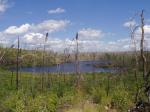
Looks like the brunt of the blow down and fire swept through this area. The launch point into Terry lake was a huge bolder field.
(picture) Bolder field portage launch site into Terry Lake. (picture) Distinct line of burn area on right side versus left side of passage.
We had to pay close attention to the map and GPS in Terry lake in order to find the 10 rod portage at the end of a small creek leading into Mora lake. Mora lake was a pretty, long and narrow lake. As soon as we shoved off from the launch point we spotted a cow moose in a small bay to the left. Mora lake had a beautiful camp site on the north end of the island in the middle of the lake. A pretty view and a nice beach area. This area was saved from the blow down and burn. The 45 rod portage into the SE tail end of Little Sag was beautiful.
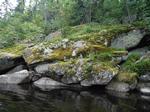
(picture) Pretty portage along rapids. We stopped for a little lunch break along the rapids. The birds really liked this section of portage and the sun was shining on the rapids.
(picture) Beautiful moss growth.
During our break we looked over the map and discussed camp site strategy when paddling into Little Sag. We decided to stay to the left, southern shoreline due to the blow down and burn area to the north side. We passed several nice island campsites as we paddled into Little Sag and stopped at a 5 star campsite halfway along the south shoreline at 2:30 pm. This was a campsite up high on a lookout rock outcrop overlooking Little Sag and all of its islands. What a beautiful view! We no sooner started unloading our gear when 2 canoes of people paddled by and verbally expressed their disappointment in finding that the campsite was taken. But there were plenty of other nice sites on Little Sag as we found out over the next 4 days. (picture) View from a Five star camp site on the south end of Little Saganaga Lake.
We set up camp, set up the Kelty tent and the rain fly. We took a refreshing swim. Mary made a delicious stir fry with potatoes and sliced steak. We shared a cold beer and Pepsi to celebrate our arrival to Little Sag. After cleaning the supper dishes and hanging the food bags for the night we enjoyed the solitude, call of the loons, and the majestic view for a short period before being chased into the tent by mosquitoes and light rain. It rained pretty steady through the night till morning. (picture) Camp site on Little Saganaga Lake offering a grand view. (picture)
Friday, August 22. After the rain stopped around day break Mary made breakfast of oatmeal, bagels, and coffee. What a view while eating breakfast! I put up the Kelty rain tarp since the weather radio report was calling for on and off showers for the next several days to come. There were loons and young ones everywhere. We saw one congregation of eight loons out in the middle of the lake yakking up a storm. An eagle flew by. We decided today was a rest day. I got fishing poles ready then we went for a paddle of Little Sag. I casted a Shad Rap crank bait along the rocky ledges, as we paddled by, looking for bass. Nothing doing. Out in the open water I trolled a 6” Stingray spoon (orange/blue) while we paddled around the southern half of the lake. I was using a baitcasting rod/reel with 14 pound firewire, an in-line deep diving sinker, and a 12 inch leader. I was looking for lake trout but caught 2 small northern of about 16” and 20”. After a couple hours of paddling around, exploring, we stopped on a tiny island to take a gorp break. It had two ancient looking cedar trees. I switched to a bronze/copper colored stingray spoon. We then paddled through a chain of islands into the northern half of Little Sag. The NE shoreline showed the burn area. The NW side of the lake was spared. We checked out a 5 star campsite on the long narrow peninsula along the NW side of the lake. NOTE: map circled campsite. The campsite had a beautiful view of the islands, 2 nice tent sites, and a unique 100 foot long trail leading to a private little sandy section of beach for swimming. We then paddled/trolled around the northern end of the lake which appears to be the deepest section of the lake. As we swung south around the NE side of a large island in order to head back to our campsite I had another strike. The fish was a strong fighter and stayed deep. I thought I had a large northern on. When I got the fish alongside the canoe I quickly realized it was a dandy trout. I quickly netted the trout. A beautiful 22” dark bronze lake trout. My first lake trout in the Boundary Waters! (picture) First Lake Trout in Little Saganaga Lake.
NOTE: marked the location on the map. I studied the Minnesota fishing regulations book since I thought it was a Brown trout or Brook trout due to the dark coloration (which I am use to catching in Wisconsin) but the forked tail told me it was a lake trout.
(picture) Back at camp Mary made a delicious trout dinner with veggies, potatoes, and cold beer. No rain all day but very overcast. We only saw two other canoes on Little Sag all day; a family camping along the southwest shoreline, behind the islands, and a canoe with 3 guys fishing along the NE shoreline.
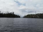
Saturday, August 23. It was a nice calm morning but overcast. A short period of sunshine gave us the opportunity to take some pictures. Mary made a great breakfast of scrambled eggs with bacon, bagels, and orange juice. After breakfast dishes were cleaned and the food bags stowed we decided to do a day trip up to Gabimichigami lake. We left at around 10 am, paddled up through the Little Sag northern islands and up the channel and 30 rod portage into Rattle lake. Rattle lake is just a little rock crevice of a lake and then a 25 rod portage into Gabimichigami lake. As we entered Gabimichigami I realized I had dropped my water bottle at the first portage. Fortunately I had an empty, spare water sack and a hand water filter pump in my day pack. When we got into open water I took a few minutes to filter and pump water into the water sack for the days travels. As we paddled around the 2 large islands just beyond the portage point we looked across the very large, very deep, open expanse of Gabimichigami lake for the first time! (picture) The wide open expanse of Gabimichigami Lake.
The ranger station staff told us that Gabimichigami Lake is the deepest lake in the BWCA. I did not have my depth finder along on this trip in order to confirm that. I got my fishing pole ready for trolling as we paddled along the southern shoreline with plans to circle around the lake. In the SW corner of the lake is a large bay with one lone camp site on an island. Very secluded. We did not paddle into the bay since I was trolling and had a lot of line out. As we paddled across the mouth of the bay, towards the western shoreline, I got a strike on the multicolored (bronze shades) 3 ½ inch, Yo-Zuri Sashimi jerkbait, using my open bail rod with 14 lb line and 12” leader. I landed a beautiful 24” lake trout. I no sooner got the fish landed and the lure back out for trolling when I got a second strike and landed a feisty 16” lake trout which I released. NOTE: marked the location on the map. (picture) Lake trout in Gabimichigami Lake.
We paddled around the north shore where the burn and blow down area was apparent. As we dropped down along the eastern shoreline there was a group camping at the eastern campsite on the mainland behind the island. This looked like a very roomy campsite and was protected from the winds by the large island just off the shoreline which also has a campsite. These were the only campers on Lake Gabi! As we passed the campsites and paddled along the island I had another strike and landed a 20” lake trout. NOTE: marked on the map. On the way back to Little Sag I casted a few times at the rapids leading into Rattle lake and hooked up with a 20” northern which I released. Back at the campsite we cooked up a lake trout stuffed with herbs and wrapped in tin foil. Mary also cooked up potatoes and veggies for a fine meal. A swim before dark wrapped up a nice day.
Sunday, August 24. Light sprinkles through the night and into the morning. We had breakfast with coffee and tea under the rain tarp. The sun broke out around 10 am. After getting our gear stowed away we took off on a day trip to check out Elm Lake which is a 26 rod portage off the NE bay of Little Sag. I had the topo map and GPS along. We checked several spots which looked like remnants of a portage trail. I hiked into several of them but the blow down and burn area had such a mess of tangled, downed trees that I could not find a trail into Elm lake so we gave up the search. We started paddling around the point towards the long channel leading up to Ecstasy lake. The head winds became really strong and dark clouds started moving in fast from the west so we decided to start heading back to the campsite. We paddled south across the SE channel of Little Sag, using the various islands for a wind break. When we got to the straight stretch along the south shore heading towards camp I casted out my bronze spoon lure and started trolling. As we passed the end island with a campsite I got a strike and landed a 20” lake trout. A short way along the shoreline I landed another 20” lake trout. NOTE: marked on the map. Back at camp we had supper and got an evening swim in. At 4:30 pm a canoe, with two people in, paddled by heading into Little Sag and checking out the southern campsites. That was the only canoe we saw all day. (picture) Lake trout on Little Saganaga Lake.
Monday, August 25. Finally a sunny, clear morning with a beautiful sunrise. We enjoyed a breakfast of scrambled eggs, bagels, coffee, and tea. At 10 am we started a day trip to explore Ecstasy lake. By the time we shoved off from camp the winds started to pick up out of the west. For the past 3 days the winds were out of the east which I found unusual. When we got to the end of the small bay of Little Sag leading up the channel to Ecstasy lake we ran into a large beaver dam. We made a 10 rod portage around the beaver dam into a small pool. In less than a 100 yards we got into floating bog and tall saw grass. We tried several different paths through the bog. I stood up in the canoe in order to look ahead and could only see solid bog and saw grass. The GPS said we were within a 100 yards of Ecstasy lake but I suspect it was almost all grown over by bog. We struggled to turn the canoe around and headed back into Little Sag. By the time we got back to base camp around 1 pm there were gale force winds out of the west. Today was our 34th wedding anniversary and we had hoped to have a campfire tonight under the stars, while looking over Little Sag since we planned to fold up camp and start heading out in the morning. We had to move the camp stove down into the woods where there was a second tent site in order to cook up supper. The ice in the insulated food bag had finally melted. (picture) Small Duluth pack on left for dry foods, insulated food pack for frigerated foods.
As the gale force winds picked up I had to take down the Kelty rain tarp. The gale force winds and rain persisted through the night but the Kelty tent held up well.
Tuesday, August 26. We were up at 6 am. Cold, cloudy, and still windy. We had a quick breakfast and broke camp. We left the campsite at 8 am with the plan to get to Bat lake and make camp for the night, allowing two days to get back to the truck. We made good time at the portages since the food packs were much lighter and we knew where the portage points were and what to expect. We had the winds at our back until we got to Gillis lake and encountered white caps blowing across the lake. We worked hard at paddling to the NW shoreline in order to follow the shoreline to the next portage point into Bat lake. Once in Bat lake it was 12:30 so we took a lunch break and decided to continue on. We reached Round lake and the parking area at 7 pm and pretty beat! It took an hour to transfer all the gear to the truck and load the canoe. We got to Sven & Ole’s for a celebration pizza, in Grand Marais at 8:30 pm. We got a motel room in Tofte at 9:30 pm and headed home the next morning. 


 Brant Lake, Flying Lake, Green Lake, Bat Lake, Gillis Lake, Crooked Lake, Tarry Lake, Mora Lake, Little Saganaga Lake, Gabimichigami Lake