BWCA Entry Point, Route, and Trip Report Blog
April 27 2024
Entry Point 61 - Daniels Lake
Number of Permits per Day: 1
Elevation: 1427 feet
Latitude: 48.0727
Longitude: -90.4358
Daniels Lake - 61
The fall falls & overlooks tour
Entry Date:
October 05, 2013
Entry Point:
Daniels Lake
Exit Point:
Clearwater Lake (62)
Number of Days:
8
Group Size:
2
Even though we had burdened ourselves with a late arrival at Clearwater outfitters, our bunkhouse was blessed with its’ own private bathroom, which aided us in getting an early start this morning. After a leisurely breakfast, we double checked our packs while we waited for the outfitters to open for the day. Vickie then gratefully grabbed one last mug of fresh hot coffee before we drove off to the West Bearskin landing to drop off the Black Pearl & our gear. Soon afterwards, we headed back to Clearwater Outfitters - they then followed us to the Clearwater Lake landing to drop off our van, & shuttled us back to West Bearskin to begin our adventure. Unfortunately, rain had started up at some point in the over night. There was also a noticeable wind that briskly accentuated the cool, misty morning temperature. Still, at the time, we didn’t think the paddling was the least bit troubling or uncomfortable. Later, when looking back at our pictures, we were somewhat shocked when they seemed to show considerably worse conditions than what we remembered. I guess we must’ve been somewhat blinded in our excitement to finally start this trip?[paragraph break]
As expected, the fall colors were in full swing. But, to a certain degree, the current conditions (gray gloomy clouds coupled with rain & fog) muted the usual brilliant color explosion. Still, we were treated to having a bald eagle & loon greet us as we paddled across West Bearskin to the Daniels lake portage. [paragraph break]
The Daniels portage was easy to locate and, (as one might expect for a portage to an EP lake) was a very well worn path. The only discernible impediment was the short climb out of Daniels, which only comes into play if heading towards West Bearskin. Per usual, my Icebreaker merino wool mid-layer performed excellently. Besides being warm & comfortable, the thumb loop holes are another aspect I really appreciate while portaging. These prevent my sleeves from rolling up when throwing a heavy pack on my back. (a particular peeve of mine.) It wasn’t even necessary for Vickie to come back across the portage a second time (although she did). We were able to get everything across in a portage and a half. It had been awhile since we could claim to have done so, and it was gratifying to see that we were still able to easily accomplish that task. The fact that the packs were at their fullest/heaviest while doing so, only added to the level of satisfaction.[paragraph break]

By the time we finished the portage the rain had stopped, but, the wind was beginning to intensify. Since we wanted to avoid the 2 sites situated along the Daniels Lake hiking trail, we hastily paddled our way north across Daniels, quartering the waves that were rolling down the lake from out of the east. After a successful crossing, we pulled into (what we thought was) the first campsite. It was certainly nothing special. A mediocre landing, subpar fire grate, not much of a view & no really flat tent pads or good tarp options. Our initial mutual assessment was to check out the other site along the northern shoreline before fully committing to a camp. But, during our inspection of the site, Vickie had poked her head out by the shoreline and noticed a real froth whipping up further down the lake. So, for better or worse, the decision was made to call this site home. (We did search for the next/other site along the north shore later in the trip & never found it. Also, looking at the map more closely back home after the trip, we determined that this was actually the 2nd site to the east from the West Bearskin landing. This also might explain why we had so much trouble locating the other site. )[paragraph break]
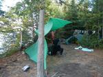
 So we proceeded to get camp set up, and not a moment too soon. A misty rain had returned & intermittingly persisted for the duration of the evening. Afterwards, thankful for the decision of claiming this camp, rib eyes & cheesy potatoes were savored while wind, waves and rain absolutely wreaked havoc out on the lake. In his book “The Singing Wilderness”, Sigurd Olson has a chapter dealing with pine knots & the intrinsic value they possess as a natural accelerant to help get a strong fire going. I didn’t walk around the woods to gather mine (I cheated & just knocked loose ones out of pallets at work) but, they proved to be just as effective and helped us carry on that fascinating tradition. A few late night games of cribbage were played under the dry sanctuary of the CCS tarp before eventually retiring to our cozy, warm sleeping bags for the night. [paragraph break]
Bearskin Lake, Daniels Lake
The rain finally relented for good at some point during the early morning hours. Still, everything was damp & wet as we arose to yet another cold, misty morning. The campfire stubbornly resisted my initial efforts but, persistence eventually paid off. Breakfast was scrambled eggs with pork sausage & onions, under a noticeably sagging, yet still quite dry (below), CCS tarp. [paragraph break]

After breakfast we loaded up the Black Pearl to start our day trip. Gloomy gray clouds once again dominated the skies throughout the day, but, the wind & rain stayed away.[paragraph break]
There was a prescribed burn in this area back in 2003 or 04. The understory has since filled in quite nicely, so at first flash, it isn’t readily apparent. However, many of the large, mature shoreline trees possess a conspicuous charcoal hued ‘shadow’ that serve as a tell tale reminder.[paragraph break]
We paddled east down the lake heading for the ‘long portage’, tracing the northern shoreline to the peninsula near the eastern end of the lake where we planned on crossing to the other side. Just as we were pulling away we passed a small opening on the peninsula which revealed a cow moose & her calf browsing down by the lakeshore. They slowly retreated back into the underbrush, making getting a decent photo a futile affair. Being October, it was alarming at how small this calf still was. Possibly the late, cold spring had delayed its’ birth? Or, perhaps, a mild winter was in the offing?[paragraph break]
As we cut across the lake in an eastern direction, we could readily discern that the campsite there was occupied by some hikers. This new discovery made claiming our campsite when we had, an ever more astute decision. [paragraph break] Arrived at the portage to discover a landing that was quite rocky, but, manageable. Once we started down the trail, it instantly revealed a very level open path all the way to Rose Lake. This portage is very unique for a multitude of reasons. The first thing most people will notice (even before attempting it) is that this portage is very long. In fact it is actually called the ‘long portage’ on many maps. Additionally, it is actually part of the Border Route Trail (B-R-T) used by hikers, with a spur running south to Daniels Lake. And, of course, it is also part of the historical Voyageurs’ Highway. (Grand Portage Neuf) However, the trail has been dramatically improved since the day of the Voyageurs.[paragraph break]
The reason the trail from Daniels to Rose was now in such exemplary shape can be attributed to the fact that the path runs over the old (long since abandoned) logging railroad bed. The significance of this old rail line with respects to shaping many important features in this section of the BWCA cannot be overstated. From its’ terminus at Rose lake the line ran SE then traced the eastern shore of Daniels lake, (this is now the Daniels Lake Hiking Trail) before heading towards Clearwater Lake.[paragraph break]
There were several spurs in the Clearwater/Caribou Lake area which are now also portions of portage trails. Then the line meandered towards Poplar Lake before turning SE. From there it headed towards the Twin lakes. This is now the Lima road that serves the Morgan, Ram & Bower Trout EP’s. Then it cut over towards Two Island Lake and ran west. This is now the gravel road called The Grade. Brule, Homer, Baker & Sawbill are all served from this road. This doesn’t even take into account the non – BWCA areas it opened up.[paragraph break]

The Long Portage certainly lives up to its’ name. Even though the trail is flat & well established, I must admit the length started to make my mind wander a bit – wondering to myself if perhaps we had taken a wrong turn, or something of that nature. Alas, we eventually came out on Rose Lake to set my doubtful mind at ease. In the final analysis, I don’t believe a portage of this length could’ve realistically been too much easier. It was a very flat wide open trail the whole way from Daniels to Rose. The only notable hindrances were a few slightly muddy spots, and various fallen logs along the way that were all easily stepped over. However, the trail did skirt a small stream for much of its length. So, dependant on the mood of the local beaver population, there could be a possibility of some sections being flooded.[paragraph break]
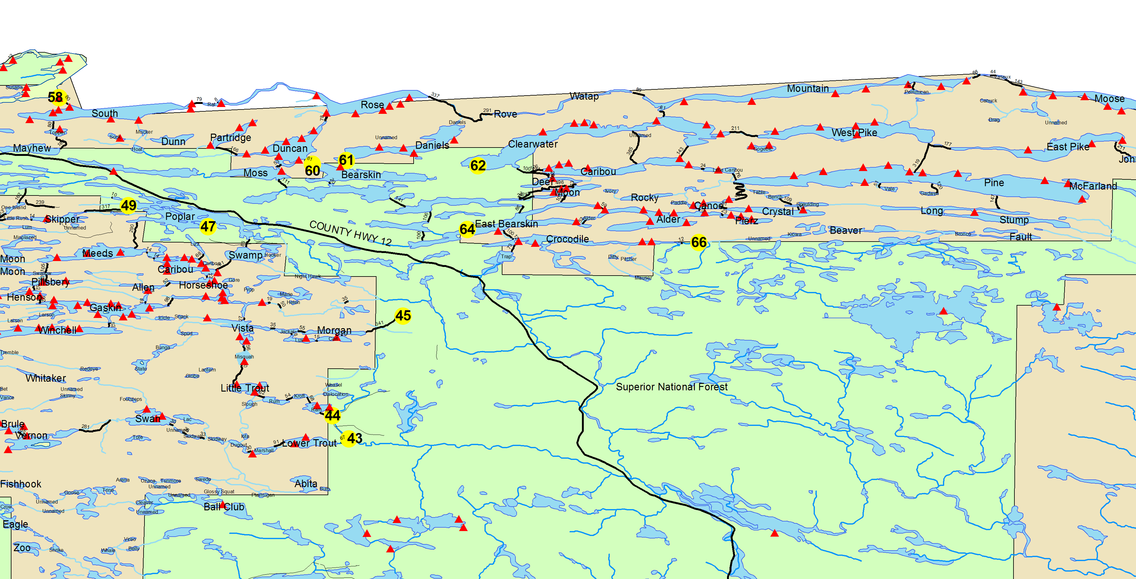
As we paddled west across Rose there was an unexpected, noticeably striking, scene along most of the shoreline. The incessant pounding of wave’s yesterday afternoon had produced a foamy outline that starkly contrasted with the dark colored shoreline rocks, making it look like someone had sprayed whipped cream all along the edges of the lake. Fortunately we didn’t have to deal with those conditions today.[paragraph break]

Even though it was a gloomy day, Rose Lake did not disappoint & we were still able to satisfactorily contemplate & appreciate the majesty of the fall colors. [paragraph break] Stairway portage beckoned. Our plan was to hike up to the western overlooks. (Overlooks, which we didn’t hike to, are also located to the east along the B-R- T.) Since I didn’t want to have to portage after getting back, I hauled the Black Pearl to the Duncan lake end while Vickie enjoyed the waterfall area. [paragraph break]

Afterwards, I caught up with Vickie and we lingered in the immediate area of the waterfall, exploring & appreciating the various perspectives from which it can be viewed, including the small bridge just above the falls. After the customary battery of photos, we pushed on west up the Border Route Trail.[paragraph break]

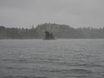
This is a very demanding section of the trail. Fortunately the top notch scenery along the way helps compensate for the exertion expended. And, for me, just being in the woods on a crisp autumn afternoon was stimulation enough. There were multiple steep sections, a couple where Vickie even got down on all fours to climb. Yet again, it seemed the distance the map showed was deficient in comparison to how far it seemed we actually traveled. But, eventually, we arrived at our destination & our perseverance was amply rewarded with a truly spectacular -breathtaking vista. Of course, a valid argument could be made that breath was in short supply by the time we got there, so there wasn’t much left to take. [paragraph break]

IMHO these are the most impressive, extensive vistas in the whole of the BWCA. Rose, Rat, South & even North Lake can all be viewed from this panoramic vantage point. After having sufficiently admired the scene, we grabbed a Clif bar snack and headed back. Obviously, we were walking on the exact same trail going back but, there was also a new perspective of looking at things while heading in a different direction. It seemed the trail was easier to traverse going this way as well.[paragraph break]

About half way back, we were startled to run across another couple heading to the overlook. After some brief conversation, we were further startled another 100 yards down the trail when we came across a trio of men also heading the same way. Quite the popular trail! Armed with the fresh indelible images in our minds, we completely understood why.[paragraph break]
Soon after, we linked back up with Stairway Portage. Being an admirer of old trees, I stopped to appreciate the enormous cedar tree near the Duncan end of that portage. We then sat & rested a bit before switching back to canoe travel. [paragraph break]
I’m not absolutely certain, but I’m guessing doing this loop the way we did was probably illegal? Since, after portaging out of Duncan, we actually exited the wilderness on West Bearskin before re-entering again on Daniels. I felt we’d be OK since the government shutdown was still in effect. Plus, the reservation season ended September 30th & I didn’t feel we would be negatively impacting any ones’ wilderness experience. Besides, we’re both rebels at heart! Worst case scenario – we’d just fill out another permit.[paragraph break]
Without impending weather to worry about this time through, we were better able to appreciate the outstanding scenery Daniels Lake provides. There was a nice little rock slide just below the cliffs along the western shore that we’d missed coming in. Not to mention the other small cliffs, islands and the undulating rolling hillsides that formed much of the lakes shoreline profile. All of this majestically crowned with the incomparable autumnal glow of golden birch leaves.[paragraph break]
One of the undesirable consequences of camping on an entry point lake is that you can be all but assured that the campsites are going to be well worn/used. So, finding legal firewood can often be an exercise in futility. With that in mind we scoured the shoreline near our camp & found an awesome sun baked cedar that (with our current supply back in camp) would more than carry us through. Although, without the saw along, we must’ve made quite a comical scene transporting this completely intact tree the couple hundred yards back to camp. [paragraph break]
We had a welcome surprise upon returning to camp. Even though it had been gloomy all day, most everything had dried. We ate leftovers for supper then, later, enjoyed our libations while watching intermittent shining stars appear in the sky, as the clouds were finally beginning to break up. Vickie jubilantly discovered that the cinnamon crème rum she’d brought was an absolutely decadent treat when mixed with her coffee or hot cocoa.[paragraph break]

Daniels Lake, Rose Lake, Duncan Lake, Bearskin Lake
The sky had mostly clouded back over. We even had enough rain over night to insure the tent & tarp were wet for teardown. After a quick oatmeal breakfast, we retraced the first leg of yesterdays’ trip.[paragraph break] 
In her book, “Woman of the Boundary Waters”, Justine Kerfoot mentions a trappers’ cabin that was located near here. 80 some years had passed since her visit, (so I wasn’t holding my breath), but I did give the area a cursory examination that, predictably, bore no fruit. [paragraph break]
Our route changed course at the end of the Daniels’ Lake spur, where we instead turned off to the right (east) & proceeded towards Rove Lake. This was also part of the Long Portage but, unlike the other section, it does not follow an old railroad grade. And, the varied terrain made this a laboriously obvious fact. Still, the ever changing micro-ecosystems & old growth trees kept things interesting.[paragraph break] With respect to this leg of the portage, my Voyageur map was a bit confusing. It seems to indicate that the portage & the B-R-T eventually fork into 2 completely separate trails. This was not the case. Nor did I see any clear evidence suggesting there was a separate portage trail. The B-R-T was/is the portage.[paragraph break]
Another revitalizing aspect that certainly lifted spirits during this portage - was finally catching up with my darkened silhouetted likeness for the first time this trip.[paragraph break]

While much shorter, IMHO this section was significantly tougher than the western leg. My hats off to anyone who does the complete portage fully loaded. It certainly merits serious consideration for the toughest maintained portage in the BWCA. But, to be clear, still a very rewarding experience.[paragraph break]
With no campsites, questionable fishing opportunities, and the fact that motors are allowed on the Canadian side, Rove Lake is probably not necessarily high on many peoples’ bucket list. Certainly its’ part of the historic Voyageurs’ Highway, but, when considering the Voyageur route in its’ entirety, even that noteworthy distinction gets lost in the shuffle when you consider there are many far more notable bodies of water along that way.[paragraph break]
But, for anyone who loves the Gunflint Trail and all that it offers, Rove Lake must be contemplated with the utmost respect. For it was here, on this lake, (presumably somewhere on the western end) that Henry Mayhew first built the trading post that led him to improve the old game trail up to this lake. Initially called ‘The Mayhew Wagon Trail’, it would, over time, become known as the Gunflint Trail.[paragraph break]
Long & narrow, the lake itself is almost river like. The B-R-T skirts along the southern edge of the lake & there are multiple spots on shore where it appears curious hikers have poked their heads out to get an unobstructed look at this little jewel.[paragraph break]

Before entering Watap lake there is a small narrows (creek if you like) to paddle through, complete with its’ own beaver dam. As you enter this section there are high towering cliffs looming just overhead which make for a most imposing & impressive backdrop. After negotiating the beaver dam, the cliffs come into view once again a short paddle later. Both Vickie & I agreed afterwards, that this was our favorite section of the whole trip.


Obviously, Watap Lake is also part of the historic Voyageurs Highway. The word Watap itself pays homage to Voyageur history. Watap was the word used to describe the spruce roots that lashed the birch bark together and to the gunwales of the canoe.[paragraph break]
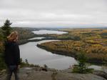
Fittingly, there seemed to be a preponderance of beaver lodges on this lake, though we didn’t see any occupants. One last short, quick rain shower fell as we worked our way east. Slowly the clouds were beginning to give way to a, long overdue, blue sky. [paragraph break] Our next portage was also very unique. ‘Portage Petit Neuf’ as the Voyageurs called it. There are some elevation changes & a few troublesome rocks along the way but, for the most part, its’ a pretty good trail. What makes this one special is the fact that it is one of only three portages that have the large monument border markers on each end. (The other two being Height of Land Portage & Monument Portage)[paragraph break]
Mountain Lake is a very beautiful large body of water. There’s supposed to be an old mine site in the first bay along the Canadian side but, we didn’t take the time to investigate. We pushed off into idyllic conditions, enjoying the brilliant autumnal setting while resuming paddling east along the American shoreline. Our target was the 3rd site down the lake, mainly so we could be closer to that (east) end of the lake for our day trip tomorrow.

For the first time the sky had really begun to open up, allowing the sun to brilliantly illuminate & showcase the fall colors. Unfortunately, the wind started picking up as well. We were approaching the widest part of the lake when Vickie noticed a succession of whitecaps out in the middle of the lake. At least the wind was blowing in from the west, so we were now getting a somewhat free, though turbulent, ride down the lake. A quick decision was made to get off the lake ASAP, alter our plans & just claim the 2nd campsite. Since, at the time, we were only a few hundred yards from the 2nd campsite, this was an enviable plan B. Besides, I consider this the best site on the lake anyways. Fortunately it was empty, so we pulled in & staked our claim.
This site has a nice pebble landing, several roomy, invitingly flat tent pads, an accommodating fire grate area complete with an expansive view north across the lake & a nice sitting area down by the shoreline. The big drawback is that the site is very open & highly vulnerable to a NW wind. Exactly what was ripping through camp as we pulled in![paragraph break]
Needless to say, it was a real chore trying to get the CCS tarp setup as a wind block. It certainly wasn’t my prettiest setup, but, it ended up creating an exceedingly effective sanctuary from the wind. Before we got the tarp up, Vickie found out just how much room we could actually have in the tent. With the wind unavoidably filling the inside, it looked more like a balloon! Things went much smoother after the tarp was up.[paragraph break]
It goes without saying that any wet gear we had was dried out in a nearly instantaneous fashion. For the second time, in as many tries, we were gratefully finishing setting up camp with a maelstrom in progress out on the lake.[paragraph break] After supper, the wind receded and we packed away all of our now fully dried clothes & gear. Vickie baked some banana nut bread while we enjoyed some beverages & recounted the events of the day while basking in the radiating warmth & flickering crimson glow of our crackling campfire. [paragraph break]
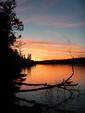
For the first time on this trip, we were also able to behold the splendor of a color drenched sunset. Hopeful that red at night meant tomorrow would be out of sight.[paragraph break]
Daniels Lake, Rove Lake, Watap Lake, Mountain Lake
We finally awake to blue skies! Of course that means the air temperature is a little crisper as well. For anyone who likes to travel in canoe country in the fall, today’s weather is exactly the scenario a person envisions when daydreaming prior to the trip. A hardy breakfast of bacon & eggs is on the menu this morning. And we’re gonna need a full tank today, because the plan is to head up to Pemmican Lake.[paragraph break]

Since we pulled up short yesterday, it was a longer paddle this morning. Not long after getting under way, we stopped at the site I had wanted yesterday, to take a short break. This was an unspectacular average site whose main attributes were the small rock stairway leading up to the main camping area & a border marker, obviously protruding out of a large boulder, just a short ways down the shoreline. Vickie felt our site was quite a bit nicer & was happily contented with the way things had worked out.[paragraph break] Every map I’ve ever seen shows a portage trail running up to Pemmican Lake just east of the campsite located below (north of) the western edge of Pemmican. This portage is no longer there. (I’ve searched in vain on prior trips.) The portage actually runs right through the middle of the aforementioned campsite #722. In fact, it’s merely an extension of the trail up to the latrine. [paragraph break] And quite the steep trail that it is. Just getting up to the latrine requires a nearly herculean effort. Evidenced by the toilet paper carnations that have been in bloom near the perimeter of camp each time I’ve stopped here.
After passing the (left) spur off to the latrine, the trail becomes more overgrown & has several large windfalls to go over, under & around. The trail isn’t overly well established, and the recent fallen leaves aided in camouflaging the actual path. I’ve done a number of steep portages, and what sets this one apart from virtually all others is the fact that it is so twisting & narrow that the canoe just barely squeezes through in many sections. This often prevents a person from being able to choose the best foothold on some of the toughest sections. You simply are given no choice as to where to plant your foot, so you have to cautiously make due. Often times having to repeatedly experiment to find exactly the right angle to turn the canoe to get through. Slow & steady wins the race. (Or, at least, gives you the best chance at being able to cross the finish line.) A person unequivocally earns their stripes getting up to this little gem.
Surprisingly, there is actually a pretty decent – expansive, put in on the Pemmican end. Undoubtedly, most people probably climb the trail, sans canoe, and fish from shore, thus (over time) opening up the landing. A stiff east wind blew for the duration of our visit here. While we enjoyed the change of pace paddling on a small, intimate lake such as this - we were concerned about how the wind was affecting Mountain Lake, so we left a bit prematurely.
As a side note: While Pemmican lake was not part of the historic Voyageurs Highway, it still owes its’ name to that colorful history. Pemmican was one of the most important staples in the Voyageurs diet. I’m particularly fond of the description the scientist Kennicott (who traveled with Voyageurs back in the day) gave. (His quote below is from Grace Lee Nutes’ book, “The Voyageur”.) “ Pemmican is supposed by the benighted world outside to consist only of pounded meat and grease ; an egregious error; for, from experience on the subject, I am authorized to state that hair, sticks, bark, spruce leaves, stones, sand, etc., enter into its composition, often quite largely.”
Once back down on Mountain we find our worries were all for naught. The big lake was still quite placid. We rested a bit at the campsite before heading back. One positive thing we did have to show from the Pemmican portage was some extra birch bark for starting our campfires.[paragraph break] A large white pine served as a towering center piece to our campsite. Not that we had any particular navigational problems, but this solitary sentinel was easy to spot from the lake & acted as our ‘lob tree’ - guiding us home. It also meant that much of our site was coated with a thin, auburn hued, pine duff blanket. There was also an old bear rope hopelessly hanging from one of the high limbs and, just below this giant, was a large, flat stone that had names chiseled on it from a group who had apparently stayed here back in August of 1968.[paragraph break]

Once again we gathered some firewood on our way back to camp. I set about processing it while Vickie started supper.[paragraph break] Vickie had really outdone herself on this trip, as our menu was absolutely stellar from top to bottom. She had dehydrated some hamburger as well as several different vegetable combinations to deliciously supplement our usual table fare. [paragraph break]

While the sun was still in the sky we checked out our campsite a little more closely. The latrine area was something of an emerald oasis, as lush moss blanketed most of that immediate area. There were also several unique fungi garnishing the perimeter, as well as a few hardy asters.[paragraph break]

We eventually converged at the campfire where Vickie, once again, worked her magic, baking some mixed berry muffins. It was a quiet, peaceful evening that afforded us an, always eagerly anticipated, opportunity to enjoy the extra special treat of viewing the pulsating Aurora Borealis. (The first sighting in the BWCA we’d viewed since our trip to Big Moose 2 years ago.) Which while in warm embrace, reminded us of our own special little light back home.
Mountain Lake, Pemmican Lake
So far, the weather had been progressively getting better each day. And, that streak was definitely upheld today. It’s always a luxurious pleasure to be able to pack dry gear away on travel days. [paragraph break]

Our lone portage of the day, to Clearwater Lake, would be a fairly tough one. Since time constraints wouldn’t be a factor, I decided to take it easy & triple this one. Once everything was across, we climbed back up to the top of the portage where the B-R-T intersects. We took the eastern fork (there is also an overlook up the west fork, which we did not hike to on this trip.) and hiked up to yet another fantastic overlook. Vickie even discovered a perfect sized (for her) hiking stick to help her along. [paragraph break]


Mountain, Clearwater & Watap lakes could all be viewed, as well as the unique profile of the Mountain lake shoreline, which has an area that kind of looks like the Florida peninsula. After soaking up some sunshine & the incredible scenery, we headed back down to grab a campsite on Clearwater.[paragraph break]
IMHO the site just west of the portage is the primo site on the lake. It was unoccupied, so we paddled over. There is a nice landing with an expansive open area for the canoe & gear. The fire grate is situated, somewhat precariously, on a high knob with a fantastic eastern view down the lake. Several pine duffed areas for tents pads were available, (though none are entirely flat or free of obstructions). A nice mature stand of pines provided shelter & several tarp options. There’s even some trail’s that stretch around the shoreline in both directions. So much like the weather, our campsite situation had steadily improved throughout the trip as well. Vickie was especially happy with the large comfortable sitting rocks overlooking the lake, as this was her favorite site of the whole trip.[paragraph break]

Even though we were in no great rush, camp had gone up fairly quickly. Since we’d had a very short travel day, there was a lot of day light left once the immediate chores had been completed. With that in mind, (for the first time on the trip), I dug out the hammock & found an ideal spot to hang it down near the lake.[paragraph break]
While this was not a particularly overly aggressive trip mileage wise, we had traversed some of the toughest portages in all of the BWCA. So, it felt good to finally be able to climb into the hammock & relax. There was just the right mixture of shade & sunlight coupled with an idyllic view down the lake, which proved to be the proper ingredients needed to melt away the accumulated strain on old sore muscles.[paragraph break]

For the most part, there was no real agenda, the rest of the day was spent just relaxing & taking it easy. This provided me the idle time & opportunity to come to a, almost embarrassing, realization. As I lounged peacefully in the hammock, it became obvious that my level of contentment had (at least for these few brief moments) reached its’ zenith, I was literally living a recurring daydream I’d had prior to the trip. All I could think was, “I am not worthy of such good fortune.”[paragraph break]
As the sun was setting, we sat ahead of the camp fire watching trout perpetually surface out on the, nearly mirrored, surface of the lake. A couple of beavers seemed intent on the goings on here in camp and swam by curiously checking us out. After we’d gone to bed, Vickie had heard one of them return & it began chewing on a nearby tree. Sleep didn’t come easily, as she was certain a tree was eventually going to fall on us. Happily, no such disaster occurred. [paragraph break]

Mountain Lake, Clearwater Lake

I don’t think there are too many sites that are better situated for viewing a sunrise? [paragraph break]
As we were eating breakfast, the serene silence was broken by our resident beaver swimming by. Indeed he had cut a tree last night, but, it was quite small & a safe enough distance from camp.[paragraph break]

This site, (like all others I’ve ever stayed at on Clearwater), boasted a large, industrious population of red squirrels, which were also noisily going about the business of making their winter preparations.[paragraph break]

Today, we would head for Johnson Falls. Clearwater was picture perfect as we’d set off. White horses were still galloping as we approached the portage to Caribou Lake.[paragraph break]

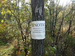
This is a tough, longer portage that has a little of everything. Still, I believe the guide books over estimate the difficulty of this one. Upon arrival on Caribou, a canoe was immediately spotted fishing just to the west - near the narrows of Caribou. This was the first canoe we had seen since the Duncan lake end of Stairway portage. As we paddled east towards Little Caribou lake, it became obvious that they were camping at the now infamous “One Match (from bwca.com) birthday bear site.” [paragraph break]
We proceeded on to the Little Caribou portage. At the start of the portage there was still a residual warning sign from that late summer ‘excitement’. Fortunately we didn’t have any problems coming, or going, across this very easy portage.[paragraph break]
Next was the portage into Pine Lake. This is, by far, the easiest actual portage in/out of Pine Lake. A babbling brook rushing by, under a small bridge, adds a special touch of ambiance. There is a hill to traverse, but nothing like the near mountainous trails elsewhere around the lake. [paragraph break] This was the first time Vickie had traveled back to Pine since our fateful trip (see my trip report, “Prisoners on Pine”) back in May of ’11, when she was 8 months pregnant with Aurora. This time a mirrored lake greeted us and it was a very short paddle across the rice beds to the Johnson Falls landing, still we hoped this would serve to exorcise those demons.[paragraph break]

It’s about a fifteen minute hike back to the falls. For the most part it’s a pretty good trail but, there are a number of spots that have slippery roots and/or rocks. Vickie now marveled (as I did back then) as to how she was able to hike this trail while pregnant. [paragraph break] Once at the falls, we checked out the lower drop first, before hiking up further to check out the upper one too. I’ve now had the good fortune of having been able to view these falls in each of the last 3 paddling seasons & I never tire of absorbing this phenomenal atmosphere. One of my all-time favorite places for sure.[paragraph break]


Afterwards, back on Little Caribou, we were feeling a little adventurous. From the portage landing we could see a distinct opening in the NE corner of the lake, so we paddled over to investigate. As we neared shore - an unmistakable dull silver/gray capped several of the shallow shoreline rocks. Once on shore, sawed limbs & trees provided further evidence that people frequented this area. Open as it was, it almost appeared as if this was once a campsite. (Though, looking at old maps of the area after the trip indicated that this was not the case.) We then endeavored to climb the cliffs just east of our present location. Barely after we got underway, Vickie came across an absolutely astonishing piece of birch bark. It was the top notch paper quality stuff & was large enough that she could’ve used it as a blanket. We stashed it back in the Black Pearl before continuing on.[paragraph break]
The climb up was basically a bush whack, but we both thoroughly enjoyed getting off the beaten path for a short while. Once up top, we were afforded a bird’s eye western view down Little Caribou & the narrows campsite. [paragraph break]

After catching our breath, we worked our way back down - then paddled over to the campsite to have lunch.
This site is perched up on a lofty rock knob that was blanketed in pine duff. It’s a very nice site that clearly gets a lot of use. It had some nice sitting rocks that were of immediate advantage. After a brief respite, I strolled down to the shore to grab some water, while Vickie dug the stove & the chicken wild rice soup out of the pack.[paragraph break]

After a relaxing lunch, we started making our way back to Clearwater.
Once back on Caribou, we ran across the 2 fellows camped there & exchanged quick hellos in passing. Later, after paddling across the large southern bay on Clearwater, our search for firewood began in earnest.[paragraph break]
We traced the southern shoreline, and had already found a few suitable trees. As we progressed west towards camp, I noticed a cedar log on shore that had clearly already been sawed. It appeared to be an excellent piece, and we couldn’t believe our good fortune. Then it multiplied! As I climbed out to claim the prize, I happened to notice another larger log, a short distance away, which sat on top of a thinly camouflaged pile of sawed & split firewood. Believe it or not, this treasure trove held 3 full arm loads of sawed & split wood! Since there isn’t a designated campsite anywhere near this spot, I could only surmise that someone had winter camped here at one time. The Black Pearls’ cargo holds were now full, so we paddled back to camp with a sweet sense of satisfaction & a canoe full of firewood.[paragraph break]
Back in camp we enjoyed the spoils of our almost unbelievable finds. We stayed up, huddled around the cozy fire, eventually finishing off the last of our ardent spirits, in what would be our latest night of the trip. It didn’t occur to me at the time, but I must admit, perhaps the reasoning for this was the subconscious impulse of not wanting this day to end. [paragraph break]
Clearwater Lake, Caribou Lake, Little Caribou Lake, Pine Lake
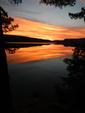
Yet, another, awe inspiring sunrise!
Half jokingly, Vickie quipped that we may have to pull the plug on the trip. At her present consumption rate, she feared her coffee supply would run out before we’d planned on leaving. Certain disaster was averted, as she was able to properly ration her remaining supply. (Of course, I firmly believe, the fact that she no longer had the cinnamon crème rum to mix it with, certainly went a long ways towards conserving what little she had left.) [paragraph break]
Today we would paddle & portage to Gogebic (Go-gee-bic) Lake. Along the way, Vickie wanted to give the small islands, near the entrance to the southern bay of Clearwater, a closer inspection.[paragraph break]

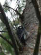
Later, upon landing at the portage, the unmistakable hammering of a woodpecker going about his business was clearly audible. Curious, I soon tracked him down on a nearby tree.[paragraph break]
The first portion of the portage is well worn and mostly flat. After the B-R-T cutoff, the trail becomes more overgrown. Shortly past this intersection, there is an enchanting spot where a short bridge crosses the small stream tumbling between Clearwater & West Pike lakes. This is another favorite spot of mine. Its’ appeal isn’t of jaw dropping beauty like so many of the areas we’ve seen earlier in the trip. No, its charms are of a more subtle, though no less relevant, nature.[paragraph break] Even though autumn had clearly left its’ indelible mark on much of the landscape, the cedars & moss in this area gave it the feel of a lush, green oasis. I always make a really intimate connection with nature when being able to listen to the cacophony of water cascading through a boulder strewn channel, (of any size), in a natural wilderness environment. It is a time tested, primal elixir for soothing the soul. This bridge offers an outstanding perch from which to do just that. [paragraph break]

Once across the bridge, the trail starts getting interesting. Not much has changed since the last time I was through here. So, I’ll quote the description from my trip report, “Shangri-La up along the B-R-T.”[paragraph break]
"After crossing the bridge is where things start to get interesting. While not overly steep, the trail begins a long steady climb. This, in & of itself, requires more than a fair share of exertion. Couple that with the fact that, for most of the climb, the footholds are almost all exclusively round, knobby, protruding rocks. Perhaps a re-routing of the trail has contributed to this condition? As there are a number of enormous trees that have all fallen curiously parallel to the trail throughout this section. Compacted soil & pine duff are finally encountered again as the trail mercifully levels off. It even begins to gradually creep back downhill. This is something of a mixed blessing. As all the elevation just lost needs to be regained again (and then some) on the final ascent.[paragraph break]
There is a "T" in the trail before it makes the final climb. This served as my next drop off point. Kelly & Ross, eager to see if indeed there was a lake at the top, pushed on up the hill.[paragraph break]
The final hill actually has some of the steepest sections. But, the condition of the trail is in better shape making this ascent a bit easier than the previous climb. Of course slowly emerging from the dense, dark forest back into the "light" adds an element of heightened anticipation as well."[paragraph break]
Vickie was immediately smitten with Gogebic lake. We paddled our way around the lake in a counter-clock wise direction, eventually pulling in at the canoe campsite across the lake from the landing. Apparently fishing had been quite slow, as there were a couple of impressive rock creations along the ‘pier’. [paragraph break]

Besides the obvious creative aspect, there was also some crafty engineering (especially on the arch) involved as well.[paragraph break]
Being the rock hound that she is, Vickie was absolutely enthralled with this campsite. Certainly most of canoe country is covered with rock, but, these near this campsite are quite unique. There is a ‘pier’ running out away from camp that is made up of countless flat stones. Several of these have been put to a most meritorious use in camp. The fire grate boasts a couple of very accommodating tables on either side & 3 rock recliners as well. I plied the waters of Gogebic while Vickie enthusiastically, and thoroughly, scoured the area. Shangri-La indeed![paragraph break]

The weather had been so nice the past few days that some determined mosquitos re-emerged in an attempt to become their usual nuisance. Much to Vickie’s delight, dragonflies were also still around to counter act them.

It took a little prodding but, eventually I was able to pry Vickie away from the rock garden. I decided to take the West Pike route back to camp, thinking we might be able to explore some of that lake too.[paragraph break]
There is a spur off the B-R-T that leads straight down to West Pike. It is a very steep trail. (Mercifully the trail is all downhill going this way.) There is also one spot where the Black Pearl just barely squeezes through a couple of trees. Once at the landing, it was apparent that the east wind was creating some chop out on the lake. So, we decided to forego our exploration of West Pike & just head back to Clearwater.[paragraph break]

Yet again, we gathered some firewood on our way back to camp, and it unintentionally served us as a excellent ballast once the eastern wind & waves caught up with us near the Mountain lake portage, where our luck had finally run out & we had to maneuver through some pretty decent rollers the last few hundred yards back to camp. [paragraph break]
With the wind howling out of the east like it was, there wasn’t much we could do back in camp. So, we explored the various trails spider webbing out from camp. Vickie stumbled onto a disturbing scene. It appeared to be a cache of (mostly eaten) food & garbage that a bear had drug away from camp. Judging from the limited decomposition of the onion, it must’ve happened fairly recently. For what it’s worth, we didn’t have (or at least weren’t aware of any) problems during our stay but, were a little more wary after this discovery.
Unlike previous evenings, the wind persisted throughout supper. It blew to such an extent that we even decided against having an evening fire. Then, continued on throughout the night, necessitating an early retreat to the tranquil sanctuary of our Hilleberg tent.[paragraph break]
Clearwater Lake, Gogebic Lake, West Pike Lake
The distinctly audible sounds of branches rustling in the wind could be heard throughout the night & continued on after we awoke for breakfast. No glorious sunrise this morning, but, as we proceeded to eat breakfast, then tear camp down, the wind was gradually beginning to recede.[paragraph break]
By the time we were loaded up, there was only a gentle eastern breeze - causing a mere ripple on the lake. After we pushed off, and were paddling through the narrows, Vickie commented that she really thought Clearwater was a very scenic lake. I informed her, the best was yet to come.[paragraph break]
As we exited the narrows, the palisades began to come into view. Naturally, the wind had not only switched directions, (and was now coming out of the west) but, it also began to rapidly intensify. We battled a perpetual succession of good sized rollers, head on, the rest of the way back to the landing. I never felt we were in any particular trouble, (fully loaded, the Black Pearl was quite stable) it’s just that we couldn’t ever let off the throttle, for fear of quickly losing ground. This was where my double bladed Bending Branches Navigator paddle really earned its’ keep. It’s so much more efficient battling a head wind with this type of paddle. Although, an unfortunate circumstance of the waves incessantly bashing us, was that we were unable to satisfactorily appreciate the indulgent grandeur of the palisades as we paddled past.

Our diligent efforts eventually got us back to the landing, where we both had caffeinated beverages waiting for us in the van. We quickly loaded up and were on our way. Since it’s right off the Clearwater road, I briefly thought about stopping at Honeymoon Bluff. But, we had a lot of driving in front of us, plus, we’d already seen it on a prior trip, so we pressed on. We were the first customers of the day at ‘My Sisters Place’ in Grand Marais. While we waited for them to officially open, we called to let everyone know we were back in civilization & would soon be homeward bound. After we finished eating, ‘The North Shore Drive’ was regaled in all its’ seasonal splendor, which made that renowned stretch of the drive back much less arduous. Once back at my brothers’, we had a joyous reunion with Miss Aurora. (Who had survived quite happily) And, the final push home - where Hannah, thankfully, managed to survive without any major problems as well.
As I finish writing this, it amazes me how well this trip worked out. So many things seemed to work out just right. ~ Weather wise, after the first day, we caught a nice window of ‘Indian Summer’. ~ The multiple times we pulled into camp just ahead of the weather. ~ Seeing the moose cow & calf. (With the mystifying population decline in Minnesota, these sightings are rapidly becoming more of a rarity.) ~ Stumbling across the birch bark, and later, the processed firewood. ~ And, of course, witnessing the Aurora Borealis. Quite obviously, this is always considered a tremendous highlight to any of my trips.[paragraph break]
Some final thoughts…. Wind can be a factor, there are some tough portages & all of the border lakes on this route allow motors on the Canadian side. West Bearskin is outside of the wilderness boundary & Clearwater actually allows 10 h.p. motors on the entire lake. (And, we did see motorized watercraft on these 2 lakes.) So, in that sense, this route might dissuade those looking for more of a wild feel. But, IMHO, the incredible scenery is unparalleled (especially in autumn), making those potential nuisances a lot more tolerable. There are just so many great spots in this (relatively) small area that you’ll definitely want to slow down & take in as much as you can. And, of course, it makes it all the better when you have a great tripping partner (like I do) to share it all with. 
Clearwater Lake