BWCA Entry Point, Route, and Trip Report Blog
April 27 2024
Entry Point 80 - Larch Creek

Number of Permits per Day: 1
Elevation: 1217 feet
Latitude: 48.1270
Longitude: -90.8304
Larch Creek - 80
Blue heaven on the Granite river
Entry Date:
July 27, 2011
Entry Point:
Larch Creek
Number of Days:
5
Group Size:
6
Wanting to get a reasonably early start, I called Dan just after 8:00 a.m. this morning letting him know I was on my way & would be at his place south of Upsala in about an hour. Thus giving him fair warning, so they would be ready to go when I got there. Clay would drive up later as he wanted to work a 1/2 day. We had a site resereved at Trails End campground, so he would meet us up there later. [paragraph break]
Arriving at Dans' it was immediately obvious that they were no where near ready to go. They were still finishing chores & hadn't even started packing! Mercifully we were off just after 11:00!!!  [paragraph break]
Finally putting some miles behind us before an obligatory stop, at DQ for hot eats & cool treats, derails us. 6:30ish when we pull into Tuscarora outfitters. Sue gets our paperwork & permit taken care of as we watch the video. Also Jodi wanted some marshmellows & Sue accomodates us there as well. Soon were on to Trails End campground where Clay is already there waiting for us.[paragraph break] 
For the most part it was a pleasant, uneventful evening. We had a nice fire with minimal bugs. We discussed our individual desires for the trip. Most of us hoped we could get a site on Clove lake. Swimming, fishing & berry picking were all high priorities as well. We turned in early to insure we would be up for the french toast breakfast at Tuscarora lodge.[paragraph break]
 Hence certainly got his moneys worth at breakfast. In fact, I'd say he got all of our moneys worth. Growing boy. :)[paragraph break]
It wasn't too long afterwards we were at the Larch creek EP landing. Almost instantly after pushing off we ran aground. We had to walk the canoe up a short distance to floatable water. Hopefully this wasn't a sign of what's to come? This EP offers a neat way to enter the wilderness. In it's early stages Larch creek is barely wide enough for a canoe to pass through.  With all the twists, turns, low spots, submerged trees, overhanging brush & weeds. It is the BWCAW version of the gauntlet, and can certainly test a paddlers moxie. More than any paddling skill set. The commodity in highest demand while paddling the course of this creek is certainly patience. [paragraph break]
It was still morning, but it was becoming quite apparent that the day was going to be a cooker.  Along the way to Larch lake there were 4 distinct beaver dams. 2 were barely above the water. While the other 2 rose up as much as a couple feet. All required only an easy pullover.
  [paragraph break]
Before reaching Larch lake there was one last obstacle worth mentioning. A reasonably large, still alive, spruce tree had fallen across the river. There was a narrow opening between some of the branches. We made sure we had nothing hanging out.... (especially the fishing poles) and blindly pushed our way through.  After all was said & done. There are a few spots where avoiding a sunken tree or log is required. But all & all the creek was very floatable for the duration, save for the one spot I mentioned earlier.[paragraph break]
As we crossed Larch lake it quickly became apparent that the southern most & island site were already spoken for. The eastern most site nearest the portage to Clove was open. But it was concluded it was too small for our crew and besides it had been decimated by the fire a few years back and ammenties, such as trees, here were scarce. Clove was our desired destination anyways, so we pushed on.[paragraph break]
We portaged into Clove. LT. Dan had the strap on his duffel bag give away and it rolled some 30+ feet down to the bottom of the ravine where the impassably small creek ran through between the lakes. Jodi was commandeered to retrieve LTs' lost load. This was Pams first ever trip so I was glad she didn't have any issues. In fact, I never heard any serious complaints (regarding the portages)from her the whole trip.  We paddled through the weed choked bay into Clove lake proper. It was then that we discovered that we would have to execute plan B. First we had to come up with plan B! [paragraph break]
For the most part it was a no-brain decision. LT. Dan voiced his displeasure about having to do more portages. But the options were this: 1.) Portage back to Larch where there was only a small unattractive site that we'd likely be miserable at. 2.) Portage across a very tough trail to the Pine river where there was only one possible site. And if it was occupied we'd have to portage back. 3.) Push north to the Granite river & Gneiss lake where there were would be several options. We chose door #3.[paragraph break]
We paddle to the north east end of Clove lake where the portage out is located. I probably should've scouted this one out first? I haul the Black Pearl & my duluth pack across before doing so. Most everyone else also makes it across with their first loads as well. Upon closer inspection the water level in the rapids are such that walking the canoes down was a more prudent option. Since the other 2 canoes are still at the other end with some gear, we decide to do just that with what would've been our second loads. If it weren't for the fact that there is an extremely sharp right turn in the middle of the rapids they could've easily been run.[paragraph break]
We have no trouble locating swamp portage. I tell LT. Dan this should be the toughest of our remaining portages. It is a mostly flat trail but is a bit muddy & is peppered with an array of somewhat annoying rocks. Also very near the northern end of the trail there is a sizeable tree down across the path. It is at that aggravating height. Tough to go over or under & impossible to go around.  There are some troublesome, slippery rocks in this area as well. Clay winds up taking a spill. He lands on the bear barrel and doesn't suffer any serious injury. [paragraph break]
As we are loading up the canoes something doesn't seem quite right. We're missing a couple of chairs! I question everyone & no one brought them across. Clay & I head back. Along with the chairs there is our fishing net and a couple of water bottles. That's a mistake we don't need to be making again. I remind everyone of the importance of hauling the same items across at each portage. [paragraph break]
The next portage is a nice flat level well worn trail that we make quick work of. We now encounter a couple sets of rapids that my Voyageur map doesn't show a portage for. They are straight non-technical rapids that appear to have sufficient water flow to run. The Black Pearl makes it through without so much as a scratch. It is really a pretty area and make note of it to try fishing here on a possible future day trip.  [paragraph break]
LT. Dan pulls out his fishing pole and soon is hootin' & hollerin' to Hence that he's got one on. Saying something to the effect of who's putting supper on the table and, probably more importantly? Who isn't. It's a small northern that will start us on the path to a possible fish fry tonight.  [paragraph break]
Our hopeful last portage is upon us! It is a very nice mostly flat well worn trail. It is also absolutely covered with raspberries. Which delayed our efforts here considerably.  The Gneiss lake end is quite muddy. I thought the view from this point was somewhat picturesque? While trying to maneuver into a better vantage point for a picture, I ran right into a rather sharp tree branch which left a nasty scar across my nose. Fortunately I was wearing my shades. Or it may have been worse? Or maybe I would've seen the branch without the shades? Anyways.....I doubt you'll ever see the photo on any magazines covers? But, with that story I now feel obligated to post it here.
  [paragraph break]
We paddled right past the first campsite as it didn't look to appealing. As we turned west around the bend, the landing to the island site looked awfully inviting. It didn't take long to discern that it was open. Without much investigation, Jodi quickly declared this would be our home for the next few days. [paragraph break]
This spot seemed like as oasis in the desert. A vast majority of the surrounding area was decimated by the fires a few years back. This island apparently had escaped unscathed and was a lush green sanctuary for weary paddlers.[paragraph break]
As we were setting up camp, Hence disappeared down one of the trails. In short order he returned with a huge smile and a smallmouth bass he had caught right from shore. LT. Dan took this opportunity to reaquaint himself with a dear friend he brings along on every trip.  It was a bottle of brandy that he calls Wilson. (like the volleyball in the Tom Hanks movie when he's stranded on the desert island). It is the one thing, more than rain gear, tent, or even food, that for him, if forgotten, could totally implode a trip. LT. Dan is constantly chatting with & always keeps a sharp eye on his dearest friend, Wilson. :)[paragraph break]
With camp setup Hence & LT. Dan decide to devote some time to fish the sharp drop off on the SW side of our island where Hence had some success earlier. Pam & Jodi just wanted to relax in a cool spot. It was still early afternoon, so Clay & I headed out to do some exploring.[paragraph break]
We set course in a northerly direction heading for the Devils' elbow area. We were dragging some small rapalas behind as we paddled. We enjoyed some success fishing. Even hooking into a "double" right at the northern most peak of Devils elbow. A couple of small smallies. We paddled down the west side of the elbow. There was an impressive rock wall where the waterway narrows.  My Voyageur map showed a campsite just after this narrow passage opens up again into lake form. So we decided to pull off to stretch out a bit.[paragraph break]
This appeared to be a fairly nice site. It was hit pretty hard by the fire but still had a homey feel. As we lingered and started wandering the outer perimeter of the site we began running into nice patches of blueberries. We went back to the canoes and grabbed our containers. We picked until we were sure we had enough for pancakes tomorrow morning.  [paragraph break]
We returned to the landing and abruptly I had a stroke. The Black Pearl was gone!!! I immediately scanned the watery horizon for anything that looked out of place. NOTHING! I then glanced off to the left and noticed a familar black object just a few yards down the shore line hung up on some overhanging branches. Apparently we were both so engrossed picking berries that we failed to hear the canoe sliding down the rocky slope at the landing back into the water. Or maybe it was the Devil?!?!?!? After all it is his elbow. :)[paragraph break]
We headed back. Stopped at the site almost directly east across the Devils elbow peninsula. There was a huge bare rock knob running down to the lake which made for a difficult landing. We were sure to bring the canoe up far enough off shore. As one might expect this site was razed as well. The trees that remained were in about the least advantageous areas for the duties they are usually used for. Also the site was incredibly exposed to the wind. Which, in one respect, might be a good thing as there was alot of grass & weeds about. Which usually translates into it being very buggy. There were berries here too, but not nearly to the same extent as the site across the peninsula.  [paragraph break]
Once back at camp we settled in for a pleasant evening. My biggest fear staying on this site was bugs. It was very grassy & weedy. Makes for a softer, easier ground to work with regarding tent setup etc. But the trade off is usually bugs of biblical plague proportion. Tonight we had no such problems. The clear sky we enjoyed all day carried on through the night & we were treated to an amazing unobstructed display of the milky way & stars.[paragraph break]
Larch Lake, Clove Lake, Gneiss Lake, Maraboeuf Lake
Hence & LT. Dan were up at first light this morning & immediately headed out fishing. I, for one, was in no such hurry. We had fresh blueberries! Certainly one of my favorite delights while in the BWCAW is the opportunity to eat fresh blueberry pancakes. Only Clay & I partake this morning, as Pam had already eaten some oatmeal & Jodi was still sleeping.[paragraph break]
After breakfast it's already starting to get quite warm. Pam & Jodi decide to take a morning swim in an attempt to fend off the heat.  Meanwhile, Clay & I decide to head over to the Pine river to see if the blueberries are of the same caliber we found there last year.[paragraph break]
As we approach the rapids running into Gneiss, we can barely make out a canoe at the top of the run. It's Hence & LT. Dan. We walk the Pearl up the rapids to where they have pulled off. We also determine that we could of easily run these rapids yesterday instead of taking the portage. We stop and chat with Hence & LT. and see that their efforts this morning have paid off. They have a handful of northerns on their stringer. We tell them our plans, and say we'll meet up with them at camp later.[paragraph break]
As we make our way back to Clove lake it becomes obvious that all of the rapids we bypassed yesterday have sufficient flow to at least walk the canoes up or down.  We pass a canoe fishing where the Pine river washes out into Clove lake. The first other people we have seen today. The campsite nearest the portage into Pine river looks unoccupied but, there are 3 fishing poles sitting near the canoe landing. A large silver & orange spoon betrays there presence. Wonder if someone left them behind?[paragraph break]
Larch creek water levels were very comparable to what we encountered last year when we entered there. So I am absolutely stunned when we get to the other end of the portage and see how much higher than water is here. We were literally able to walk out a few hundred extra yards before running into water here last year. And it will be a grueling bushwhack to get to the spot where we picked berries last year without the canoe. Time for plan B......again.[paragraph break]
We decide to walk the shoreline, and it isn't just too long before we hit paydirt.  We find an abundance of tempting bushes, and pick until our backs and knees start telling us it's quittin' time.[paragraph break]
Heading back, just after the portage out of the north end of Clove lake is a nice sheer cliff on the U.S. side that rises 20 - 25 feet. There are a couple canoes there and some kids are jumping into the water. I think the lightbulbs above our heads went off at about the same time? We'd be back tomorrow with Hence & Jodi to try this out for ourselves. [paragraph break]
We only did Swamp portage and the one right after it on the way back. Otherwise we walked the Pearl down the one out of Clove, and actually ran the rest without incident all the way back to Gneiss.[paragraph break]
There is clear, undeniable evidence of the burn all the way back to Clove and Larch lakes. But once you portage north out of Clove.....the scope and magnitude of the damage the fire did really starts to hit home. Once on Gneiss it seems like something out of a science fiction movie. Surreal. And with all of the exposed rock, it becomes very obvious why it's called the "granite" river. But, for me, once my senses are adjusted and become acclimated to the starkness of the landscape. It seems to have a uniqueness and beauty all it's own.
Back at camp we returned just as LT. was cleaning fish. He had some eager spectators nearby waiting patiently for the spoils of his efforts.  Soon they were satisfied as LT. began frying up His & Hences' catch for the day.
  [paragraph break]
After eating, LT. spent a good deal of time with Wilson. I'm not sure what they were talking about? But whatever it was, it must've been exhausting as LT. headed for his favorite hang out after having a lengthy discussion with Wilson.  [paragraph break]
Afterwards LT. asked if we noticed that any sites on Clove were open. He wanted to move. This was completely baffling to me. Having been to this area the last couple of years I could say was a high degree of confidence that we were already at the best campsite from Devils elbow all the way to the 2 southerly EP's that serve this immediate region. Never did get a responce on why he wanted to move. I just figured Wilson was doin' the talkin'?[paragraph break]
I had done a fair amount of reading this past winter. Most of the books dealt with the Voyageurs & their routes. While the Voyageurs certainly covered many lakes, I think here along the Granite river and the narrows between some of these lakes is where a person can achieve the greatest sense of intimacy with the route the Voyageurs of long ago took. It's all but certain we were stepping on some of the very same rocks along the rapids and narrow sections. In fact some of the most productive finds the archealogical dives of the 60's & 70's were right here along the Granite river. "Voices from the rapids" does an excellent job of chronicaling those dives.  While sitting around at camp it didn't take much imagination on my part to envision them cruising by with a birch bark canoe full of goods. Or how quickly they would do the portages with ridiculously larger loads. I wondered how the landscape looked back then. How, perhaps, the route was different with respects to water levels? Trading rum to the Indians for wild rice, bluebrries, & "bustards" (Canadien geese). Along with virtually any wild game they could get their hands on. I guess what I'm trying to say is that I had a new sense of appreciation & understanding for this beautiful & historic area on our visit. [paragraph break]
Weather wise this day was almost a carbon copy of the previous. We had few problems with bugs & mosquitos yesterday. So we expected the evening"bite" to be similar as well. But, when evening fell and the harrowing drone of mosquitos overtook us, we were a bit surprised. For the most part, if you had repellent on they didn't bite. But the incessant buzzing was approaching madness. Hence was a bit bolder than the rest of us. Braving the onslaught shirtless. After all was said and done, everyone retreated to their tents prematurely. 
 [paragraph break] Gneiss Lake, Clove Lake
Another blueberry pancake breakfast! The morning was shaping up just as the past two had. LT. & Pam decided to do some exploring and fishing. They paddled off in the direction of Devils elbow. Hence & Jodi were excited to go to the cliffs. We grabbed a few essentials and paddled back up river towards the cliffs.[paragraph break]
Upon reaching our destination, Clay lead the way to the top. The area was absolutely covered in blueberries. We'd get to those later. I told everyone to wear their PFD's just to be safe. Clay was the first to jump.  Jodi went next, then Hence. The smiles on everyones faces insured that this was something that was going to be repeated several times.
  Everyone jumped multiple times. The only bad part was it was a rather vigorous climb to get back to the top of the cliff to go again. But the reward seemed well worth the effort.
 Bombs away!!![paragraph break]
After everyone had gotten their fill of jumping. We focused our collective attention on the vast amounts of blueberries in the area. Problem was we really didn't have any containers along on this daytrip. So we go to plan B yet again. We empty the small collapsible cooler we had along. Also everyone eats the rest of the beef jerky so that plastic bag is empty as well. Finally, I use the ziplock bag I store my emergency matches in and we are good to go. After some time had passed, Clay notices some menacing clouds building towards the west. We quickly decide to paddle back to camp. Hoping to beat out whatever this system has to dish up.[paragraph break]
We made it back to the last set of rapids before Gneiss lake before a light sprinkle started coming down. As we rounded the last bend towards our campsite LT. & Pam could be seen watching for us. Once we were within eyeshot they retreated to the dry sanctuary under the tarp. We joined them there after landing our canoes.  It was already starting to break up as blue skies were seen above. All told it rained for no more than 15 - 20 minutes.[paragraph break]
Jodi is a person who can never get enough swimming in on a trip. If they'd find a way to serve ice cream every day up there? She'd spend the whole summer! Shortly after the rain had stopped she headed over to the west end of the island. There is a nice drop off right from shore here. With a rock platform rising some 3 feet straight up from the water. This area served Hence well while fishing from shore. But as a secondary function it was also a great area for swimming and the water depth allows a person to dive right from shore.  [paragraph break]
Meanwhile back around the firegrate Wilson was hanging on by a thread. Both literally & figuratively.  [paragraph break]
With Wilson no longer able to distract him, LT. Dan was finally able to focus on picking some blueberries.  So we loaded up and headed out in search of blueberry hill and the accompanying thrills it would no doubt provide. Lt. claimed they had run across a promising spot earlier today. It was a tough place to land a canoe but it had enough clusters of berries that you could literally just lay down and start pickin'.
  It seemed that no matter where we pulled off there was another stellar patch. You could say it was America the beautiful? With purple mountain majesty across the fruited plains.[paragraph break]
The ankle biting flies were of a particular nuisance. So LT., Pam & Jodi headed back to camp to strengthen their defenses. In the meantime Clay & I had given this spot a dirty beating and paddled a little further down the lake to another similarly productive area. Only LT. & Pam returned. And we picked until all of our respective containers were full. Which didn't take long.[paragraph break]
 Aside from the bugs...It was shaping up to be yet another glorious evening. We slathered on a fresh coating of deet around our ankles and lounged around camp enjoying the peaceful setting. [paragraph break]
Before nightfall, LT. & Jodi swam to the nice bluff just across the channel from our island. After admiring the view it afforded the swam back. Upon his return to camp LT. promptly retired to the cozy confines of his tent & sleeping bag. A short while later, with LT. sound asleep, Hence & Jodi were literally crying telling Clay & I to come look inside the tent. And to bring our cameras! The photo quality is not the best thanks to the no-see-um mesh. But, it appeared to us that Wilson had gotten the last laugh on LT. Dan.  LT. would later claim that was where he sat down with his wet swim trunks. But I'm gonna stick with the Wilson story. ;-}[paragraph break]
With Pam & LT. sleeping already, the 4 of us remaining half heartedly faced the "bewitching" hour. When the mosquitos would come out in their full fiery. I was a bit more cowardly than the others. Scrambling for the tent at the first sound of buzzing. But no one stayed up all that much longer. Sometimes you just gotta know when to say when?[paragraph break] Gneiss Lake
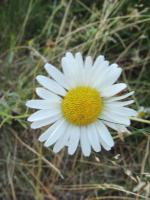
Time to head out. We're up pretty early and, after a quick oatmeal breakfast, get things packed up quickly. I must say that this campsite was a beauty. Especially when you factor in that virtually all the sites within a few miles of here were razed by the fire. Beyond what I've already mentioned. There were a few of the most impressive jack pines trees here on the island that I can ever recall seeing.  As well as several pretty flowers.
 It was a real pleasure spending some time here.[paragraph break]
The cargo holds on the Black Pearl are nearly maxed out as we load up our bounty of blue treasure. Bet you can't guess which bucket is LT. Dans'?  [paragraph break]
We only do swamp portage and the one between Clove and Larch lakes on the way out. All the rest we are able to walk the canoes up. 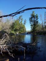 We come up on an immature bald eagle at the tiny island on the north end of Clove lake. A nice regal send off. Everything goes pretty much as scripted on the way out. We are back setttling up at Tuscarora lodge outfitters by 11:00 and eating burgers before noon at the new & improved Trail Center.
  [paragraph break]
Clay has to work early Monday morning so we bid him farewell after our meal at Trail Center. The rest of us finally part ways after stopping for gas in Tofte. I don't have to work until Wednesday and turn off at Highway 1 and head my for parents place to visit them, and give them one of the pails of blueberries. [paragraph break]
In our little piece of heaven we had the luxury of an over abundance of blue skies, blue waters, & blueberries. We were truly blessed. Gneiss Lake, Clove Lake, Larch Lake
I've made a return trip in 2012. Here is a link to the photos from that trip. http://s1220.photobucket.com/albums/dd449/TuscaroraBorealis/Clove%20lake%20beach /?albumview=slideshow Otherwise you can go to the comments section for a direct link & a video.