BWCA Entry Point, Route, and Trip Report Blog
June 26 2026
Entry Point 33 - Little Gabbro Lake

Little Gabbro Lake entry point allows overnight paddle only. This entry point is supported by Kawishiwi Ranger Station near the city of Ely, MN. The distance from ranger station to entry point is 23 miles. Access is a 200-rod portage from the parking lot to Little Gabbro Lake.
Number of Permits per Day: 1.5
Elevation: 1235 feet
Latitude: 47.8481
Longitude: -91.6357
Little Gabbro Lake - 33
Number of Permits per Day: 1.5
Elevation: 1235 feet
Latitude: 47.8481
Longitude: -91.6357
Little Gabbro Lake - 33
85 Challenging Miles Solo (EP 36 Entry to EP 37 Exit)
by cabinsolutions
Trip Report
Entry Date:
June 18, 2026
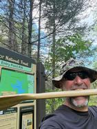
Entry Point:
Hog Creek
Exit Point:
Kawishiwi Lake (37)
Number of Days:
4
Group Size:
1
Trip Introduction:
This trip has been on my radar for two years. I planned to go last season, but I was unable to go due to family obligations. So, this year a permit came available last minute, and I dusted off my plan and away I went! The main purpose of this trip was to test my ability to check-off miles and determine how much training I would need prior to taking on the Border Route Challenge. The route stretched my navigation skills, mental toughness, and physical abilities as a solo. Shout out to Straighthairedcurly and Jaywalker for your detailed trip reports that assisted in my planning....many thanks!
Day 1 of 4
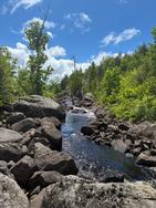
Thursday, June 18, 2026 17.8 Miles: Hog Creek to Isabella River Camp 1928. 9.5 hours[paragraph break] 0630: Put-in Hog Creek. 1600: Arrive Camp 1928.[paragraph break] Key Points: NW headwind 10-15. Overgrown Perent River Portages, Wind on Isabella, Crowded Isabella.[paragraph break] I started out with the slow winding Hog Creek paddle to Perent Lake. This section is quite beautiful and took about 1.3 hours to complete. There are a couple beaver liftovers following the short initial portage. Navigation was pretty straightforward except for trying to keep your bearings during all the turns. Water levels were low but navigable.[paragraph break] 0750: Arrived Perent lake and oriented on the islands and open water. Similar to others commenting on this lake, it is a bit deceiving after you spent time winding on the creek. I recommend pausing here to orient your map and identify your line across. In my attempt to quarter into the NW headwind, I paddled too far west and ended up in the wrong bay. A quick pause, and I noted I needed to point straight north and clear the next major point before turning west towards the Perent River portage. If you are paddling from Hog Creek to this portage, consider following the eastern shore for awhile if the winds allow. You'll be able to guide off the campsites a little easier before turning west. [paragraph break] Arrived Perent River about 0850. Paused for hydration and a snack while studying the map for the upcoming 13 portages. As a general comment, these portages are all difficult to spot with the dense foliage. Once you are on them, you will find yourself bushwhacking while trying to follow the goat trail underneath. As I single portaged, I was careful to watch my footing and if the canoe bumped into something, I negotiated that obstacle. This approach was for safety. It is very easy to turn an ankle and take a fall along these portages. They are rocky. The first six portages are fairly straightforward. Refer to the commentary offered on this site and you'll be able to understand the specifics. The seventh portage from east (224) is a after you navigate a shallow rock garden. You'll think that it should be coming up and there's no way you need to navigate the rocks, but you do. You'll find it on the north side following the rock garden. If water levels get any lower, I assume this will become more difficult later in the season. I was unable to find the 8th portage (225). It is suppose to be on the North side. I ended up just paddling this and getting out and pulling the canoe through a few areas of this section. I don't know if you actually need to portage around this rapids. The 9th portage (674) was on the south side right next to the rapid entrance. The map shows this on the north side, but I looked for several minutes here and finally gave up and started looking for other options. Sure enough, it was mis-marked on my Voyaguer map. The remaining portages to Isabella were a little easier to find and were better traveled.[paragraph break] 1400 Arrived Isabella Lake. This is where the wind kicked up, I could see the washing machine churning! I decided to re-trim my NW solo canoe to 'weight-forward' and give it a test run. If it was too dangerous, the plan was to bail south to one of the southern campsites or EP 35. After entering the melee, I found the NW solo to be very seaworthy, and I beared down with the double blade paddle and plowed across, sticking to the southern side. The middle section was chaos with unpredictable wave breaks. As, I neared EP 35, the waves became more manageable, and I was able to let up a bit. I arrived at the Isabella River portage thankful to have that stretch behind me. Of note, all campsites on Isabella were occupied. I assume others were windbound and decided to sit it out that day. I portaged through to the Isabella River after checking out the bridge on the Powwow Trail. I had an uneventful paddle west to Campsite 1928 and was thankful to find it available and pulled in around 1600. Recovery drink, evening chow, established camp and hit the rack around 1900.[paragraph break] Random thoughts: The Garmin network went down for about 2 hours during that afternoon. Livetrack and navigation was down. This is just a reminder to not rely on a single tool for navigation and never trust anything with a battery! I didn't realize it was down until my family texted my InReach later telling me they lost the track during that timeframe. ~Hog Creek, Perent Lake, Boga Lake, Isabella Lake, Isabella River 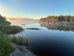
Day 4 of 4
Friday, June 19, 2026 24.7 Miles: Isabella River Camp 1928 to K. River Camp 1138. 9.5 hours[paragraph break] 0630: Departed 1928. 1600: Arrive Camp 1138.[paragraph break] Key Points: NW headwind 10-15mph. Well-Traveled portages, Quiet section until Bald Eagle.[paragraph break] 0500 Reveille followed by much stretching, breakfast of power oatmeal and coffee. I broke camp and was on the water about 0630. Conditions were overcast and calm. Today, I planned to make up some miles that I felt I had lost the previous day (my goal was just over 20 per day). This section was uneventful and very beautiful as I paddled thru the Pagami burn. The regrowth was lush, and I saw many bald eagles along this stretch. The portages were all easy to find and marked accurately on the map. The final portage before reaching Bald Eagle is long, but was a welcome leg stretch after several paddling miles. I didn't see a person until I reached Bald Eagle. With only a slight NW headwind, I made quick work of Bald Eagle. I stopped for a lunch break on a nice rock in the channel between Bald Eagle and Gabbro. Following that break, I pulled over the rapids to Gabbro and cruised through there and Little Gabbro before arriving at the northern portage to enter the K. River. This again was a welcome portage to get the blood moving in the legs after a decent paddle. Upon entering the K. River, I started looking for campsites. All of them were full as I passed until I reached 1138. This was an island site perfect for one person. I pulled in about 1600. I quickly established camp, had a recovery drink and dinner before the rain started. I think this section was crowded due to the number of permits for the Lake One entry (13 daily). People seemed to be filtering down from the north that day. ~Island River, Rice Lake, Quadga Lake, Bald Eagle Lake, Gabbro Lake, Little Gabbro Lake, Kawishiwi River 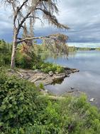
Day 7 of 4
Saturday, June 20, 2026 23.6 Miles: K. River Camp 1138 to Alice Lake Campsite 1164. 9 hours[paragraph break] 0630: Departed 1138. 1500: Arrive Alice Lake Camp 1164.[paragraph break] Key Points: Tailwind, Busy Section, Navigation Hiccups, Insula Portages[paragraph break] 0500 Reveille followed by power oats and coffee. I broke camp and started paddling NE along the river in calm conditions. After a couple quick portages, I was on Lake One with a tailwind building. I made it quickly across the numbered lakes with little issue. This is where I achieved my top speed of 9.5 mph while going through a narrow channel pushed by a stiff tailwind. Thankful for that wind on day three! Portage 624 heading to Lake 4 eluded me slightly. I guided off the nearby campsite (1505), but failed to enter the correct channel just to the SE. Once in the correct channel, the portage was obvious. I chalk this up to being tired and losing focus for a moment. Once through, I quickly traversed Hudson. The portage from Hudson to Insula was a challenging, rocky, steep up and over. It is only around 95 rods, but be prepared for a steady climb and rocky descent. Watch your footing, especially on the Insula end. [paragraph break] I paused for lunch before entering Insula. This lake has many islands and can confuse you if you aren't paying attention. I chose to bank NW as soon as I was able in order to get on the lee side. I bypassed the first small channel (mistake) because it didn't appear to go anywhere. So, I ended up going too far east before getting back on track. After that, I was able to guide off campsites and islands to get me to "The Rock". Once I hit this section, I could see the northern channel that allows you to skirt through before turning east to Williamson's island. Once again, I overshot a bit playing the wind, so I had to drift back south once I got to the east shore. The channel to the portage is a little disguised. But, if you guide off campsite 1323 and go to the east of that, you'll roll into the correct channel. After turning south into the K. River again, the remainder of the day was uneventful. [paragraph break] 1500 I arrived Alice and decided to call it an early day knowing I was within shot of completing my journey the following day. I stopped at Alice Lake site 1164 and enjoyed a swim and some relaxation prior to the final push. [paragraph break] Random thoughts: I found the open-lake navigation to be the most challenging. Things tend to look the same, and when you are solo, you start second-guessing yourself. I used all navigation aides during the trip to include, map, compass, InReach, and the sun. I prefer a hard copy map and compass, but the InReach helped to verify my plan allowing me to paddle an efficient track.~Lake One, Lake Two, Lake Three, Lake Four, Hudson Lake, Alice Lake 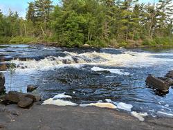
Day 10 of 4
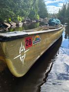
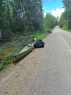
Sunday, June 21, 2026 18.8 Miles: Alice Lake 1164 to EP 36 Hog Creek (via EP 37) 8 hours[paragraph break] 0600: Depart 1164. 1400: Arrive EP 36 Hog Creek (mission complete).[paragraph break] Key Points: Familiar territory, steady traffic, wonderful conversations, 2.5 mile portage from EP 37 to EP 36.[paragraph break] 0450 Reveille followed by hasty breakfast and pack-up due to ruthless mosquitos. Departed 1164 and made quick work of the two portages to K. River/Fishdance. I pointed NE up the river along familiar territory from a trip 2 years prior. It was nice to just focus on my surroundings without concern for navigation during this final stretch. I chatted with a wonderful couple who was enjoying breakfast along the shoreline of the island site 1969. Then, I chatted with a solo fisherman just north of the island before turning into the river portage to Malberg. He informed me that the previously flooded portage (562) was now drained and dry. I was thankful for that news as it was quite a muddy mess the last time I was through there. After enjoying that 60 rods on dry land this time, I entered Malberg and enjoyed a calm paddle through the many arms towards the Koma portage. I paused to take a picture of site 1053 where I stayed two years ago and had some fond memories of assisting some Girl Scouts who experienced some challenges. Malberg and Koma were empty. I arrived at Polly around 10 am and started seeing several groups enjoying this popular destination. I pushed through to Townline and K. Chong and met 4-5 groups heading in. Of note, the Forest service has done a nice job extending and enhancing the boardwalk on the Townline portage. I enjoyed the final paddle in and met a wildlife photographer at the portage to Square. We chatted for a few minutes, and I learned he was out searching for bull moose in velvet. He was unsuccessful in his search, but he was an interesting gentleman to chat with and share some stories as we each completed our journeys. Finally, I pushed through the creek to Kawishiwi. The lake was empty and I arrived at EP 37 around 1215. After taking a few pics, I paused at an open campsite and had a quick lunch. After that recharge, I geared up and started the 2.5 mile portage back to my truck at EP 36. This was a good test of endurance for sure. I had several people stop and offer to assist, but I gracefully declined because I wanted to complete the loop 100% on my shoulders (literally!). After a few rest stops, I arrived at my truck around 1400 fully satisfied with my efforts and successful completion. The exhaustion began to hit as I loaded my gear, but it was a wonderful feeling! [paragraph break] Final thoughts.....[paragraph break] -It's important to push yourself beyond what you think you can do in order to prove what you are capable of doing. [paragraph break] -I need to train more prior to taking on the Border Route Challenge[paragraph break] -Mental toughness outweighs the physical [paragraph break] -Solo navigation requires complete focus[paragraph break] Gear Loadout:[paragraph break] -NW Solo canoe w/double blade Werner paddle and Bending Branches Paddle ~30 lbs[paragraph break] -Base weight: Granite gear pack 47.6 lbs. Worn weight (Clothes, PFD, Shoes) 2.4 lbs. Total 50 lbs.[paragraph break] -Total starting weight: ~80 lbs [paragraph break] InReach Trip Stats: [paragraph break] -84.9 miles [paragraph break] -46 portages[paragraph break] -3.75 days [paragraph break] -Ascended ~3848 feet of elevation [paragraph break] -Descended ~3720 feet declination [paragraph break] -Top Speed 9.5 mph [paragraph break] Many thanks to Sawtooth Outfitters in Tofte, MN for renting me another awesome canoe! ~Fishdance Lake, River Lake, Malberg Lake, Koma Lake, Polly, Lake, Townline Lake, Kawasachong Lake, Square Lake, Kawishiwi Lake 
Lakes Traveled:
Fishdance Lake,
River Lake,
Malberg Lake,
Koma Lake,
Polly, Lake,
Townline Lake,
Kawasachong Lake,
Square Lake,
Kawishiwi Lake,
discuss this trip report (0 comments) - last post on June 26, 2026