BWCA Entry Point, Route, and Trip Report Blog
April 27 2024
Entry Point 38 - Sawbill Lake

Sawbill Lake entry point allows overnight paddle only. This entry point is supported by Tofte Ranger Station near the city of Tofte, MN. The distance from ranger station to entry point is 25 miles. Access is a boat landing at Sawbill Lake. This area was affected by blowdown in 1999.
Number of Permits per Day: 11
Elevation: 1802 feet
Latitude: 47.8699
Longitude: -90.8858
Sawbill Lake - 38
Number of Permits per Day: 11
Elevation: 1802 feet
Latitude: 47.8699
Longitude: -90.8858
Sawbill Lake - 38
Sawbill to Lake One, Across the Center of the BWCA
by TominMpls
Trip Report
Entry Date:
July 02, 2018
Entry Point:
Sawbill Lake
Exit Point:
Lake One (30)
Number of Days:
7
Group Size:
2
Trip Introduction:
My teenage daughter M and I have done several BWCA trips together, mostly just the two of us. All of our trips together have been from Echo Trail entries, and they've always been loops. We decided to try something different and, logistics be damned, cover some new ground. We liked the idea of a point-to-point trip, since this would get us deeper into parts of the BWCA that people rarely see, and would give us more solitude.
People rarely do point-to-point trips for a reason. To make the logistics work, we had many requirements and some preferences: with only one car, we wanted the car to be at the exit, not the entry, so we could leave whenever we reached the end without trying to coordinate a schedule or meet a shuttle. We wanted to do all the logistical shuffling the day before our entry, not the same day, so that we could wake up and go straight to the wilderness. We wanted an entry point that would allow us to sleep right at the entry, with no logistics involved in getting to it without a car. We wanted an exit that would be easy to meet a shuttle at to take us to the entry. And given the hoped-for solitude of a point-to-point trip, we didn't really care if the entry and exit day were a bit crowded.
Sawbill, with both an outfitter and a campground right at the entry, and being about the right distance from the Fernberg Road entries, became the obvious target, and a quick call to Sawbill Outfitters confirmed that they could shuttle us. Though I played with other exit points, once we'd chosen Sawbill as the entry it quickly became clear that Lake One, despite being the freeway on-ramp of the Boundary Waters, was the logical exit point, as it met all our requirements without putting us on a motor lake such as Snowbank or Moose.
The hassle and expense of a point-to-point trip were largely mitigated by the fact that this year we finally own our own canoe and are finally now completely self-outfitted, so there would be no rental costs; and M loves Ely, so the extra time in Ely to make the logistics work was a perk, not a disadvantage. It padded out our seven day, six night trip to nine days.
Part 1 of 9
Saturday, June 30 - Two Days To Go
We got up Saturday morning and threw our relatively small amount of gear into the car. Our two portage packs together weighed 102 lbs - 55 in the Guide and 47 in the Pioneer - and our only other gear was a small bow bag, two map cases with four maps each, the paddles, PFDs, and canoe. The drive up from Minneapolis to Ely was uneventful except for two things: on my first trip to the BWCA with my own canoe, on highway 33 we were flagged into a DNR checkpoint to check for invasive species, which was fun and interesting since I'm involved in a project on these in my professional capacity but had never seen one before. They were quick, pleasant, and remarked on our beautiful canoe, and we were on our way. Just a short while later, on 53, a black bear ran across the road a few hundred feet in front of us, which was an exciting way to start the trip.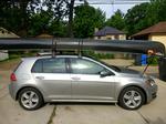
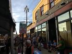
We arrived in Ely, checked in to the Adventure Inn, and got a delicious late lunch - per usual - at Insula. After lunch we bought a few last-minute things and window-shopped at Piragis and wandered around Ely, doing all the things we usual do, and eventually got a light "dinner" of duck wings and pretzels at the Boathouse, then hung out at Crapola's "Crapola Fest" which was happening. Live music, beer, and games for a little while, then an early night to save our energy.
We got up Saturday morning and threw our relatively small amount of gear into the car. Our two portage packs together weighed 102 lbs - 55 in the Guide and 47 in the Pioneer - and our only other gear was a small bow bag, two map cases with four maps each, the paddles, PFDs, and canoe. The drive up from Minneapolis to Ely was uneventful except for two things: on my first trip to the BWCA with my own canoe, on highway 33 we were flagged into a DNR checkpoint to check for invasive species, which was fun and interesting since I'm involved in a project on these in my professional capacity but had never seen one before. They were quick, pleasant, and remarked on our beautiful canoe, and we were on our way. Just a short while later, on 53, a black bear ran across the road a few hundred feet in front of us, which was an exciting way to start the trip.
We arrived in Ely, checked in to the Adventure Inn, and got a delicious late lunch - per usual - at Insula. After lunch we bought a few last-minute things and window-shopped at Piragis and wandered around Ely, doing all the things we usual do, and eventually got a light "dinner" of duck wings and pretzels at the Boathouse, then hung out at Crapola's "Crapola Fest" which was happening. Live music, beer, and games for a little while, then an early night to save our energy.
Part 2 of 9
Sunday, July 1 - One Day To Go
We got up kind of early, had hotel breakfast, and started our logistics day. Not knowing what Sawbill Campground would be like, but knowing that I hate getting my tripping gear all unpacked before the trip even starts, I'd scheduled a shuttle pick-up as late as seemed reasonable, 4:00, with the plan that we'd have a late lunch just before the shuttle pickup, and then not eat again until the next morning. So we had lots of time to look around Ely on what turned out to be a cloudy, and then rainy, day.
We picked up the permit early at the Kawishiwi ranger station, which was quick and uneventful. They reminded us of all the rules - again - but didn't have us watch the video yet again, and we were out. We looked around the surplus store and then decided to bowl for a while at the Ely Bowling Center - first time I've manually scored bowling in probably a decade, but it was good fun. We had Bucky Burgers at the Ely Steakhouse and headed to the Lake One entry.
I hadn't been to a Fernberg Road entry in fifteen years and M has never been to one, so I'd forgotten how quick and easy they are compared to the Echo Trail entries. We got to Lake One about forty minutes early, in a substantial rain, and thought we'd be sitting for a while, but it turned out that the outfitter had the same experience, so Bill and Claire from Sawbill were loading our canoe onto their truck about 3:30 for the drive to Sawbill. Bill, the former owner of the outfitter, had a wealth of knowledge both about our trip route and about the region in general, and his forest road route between the two EPs was much shorter than I'd planned it to take. Claire, a recent college graduate employee of the outfitter, was taking advantage of our shuttle to get her own car shuttled to the same exit, for a trip she was taking with a friend between the same two entries. Inspired by our plan (and our rather expensive shuttle), she was planning a more aggressive four-day trip, using the Louse River route instead of the Lady Chain route we were using to get from Sawbill to Malberg.
Though it had been raining hard for most of the drive, we arrived at the outfitter just as the clouds were lifting and the rain was little more than a drizzle as we unloaded our gear to a site. Bill suggested a different (available) site from the one I'd reserved back in January, so we dropped our stuff at his recommended site and walked back to the outfitter office to pay for the shuttle and check in. We also bought some ramen, candy, a beer and a soda, and headed back to our site, the sun breaking through the clouds for a beautiful evening. The campground host yelled at us for being at the wrong site (not our fault!), but other than that it was a perfect evening at a surprisingly nice forest service campground.
Part 3 of 9
Monday, July 2 - Day One
We were woken super early to my cell phone's work alarm which I'd forgotten to disable, but we took our time getting out and going. Once everything was packed up, we walked everything to the landing, had outfitter coffee and pop-tarts for breakfast, and hit the water at exactly 8:00.
On a beautiful Monday morning, we moved quickly up Sawbill, took the Sawbill-Alton portage quickly, and saw the only other person we'd see all day fishing on Alton Lake. Within an hour of starting we reached our first significant portage, the Alton-Beth portage. With two roughly 50-pound packs and a 50-pound canoe, we'd decided we'd 1.5-portage this trip, and so this was our first significant chance to try it out - we've always double-portaged in the past. M grabbed the heavy pack and I grabbed the canoe, and we walked until my watch showed a quarter mile, then she set down the heavy pack to go back for the lighter one. I walked to the end of the portage, put down the canoe, and went back for the heavy pack, which in theory would mean we'd both reach the end of the portage together with the two packs, but youth is wasted on the young and I met her coming with the lighter pack before I was close to the heavier pack. This would become the norm for the whole rest of the trip, and so by the time I got back to the canoe with my half-carry of the heavy pack, she had everything else all ready to get back in the water. We both immediately realized that 1.5-portaging is absolutely brilliant.
A short paddle across Beth brought us to the longest portage of the whole trip, at just under a mile the Beth-Grace portage that supposedly thins the herd on the Lady Chain, though we hadn't seen anybody except that one fisherman anyway. The Beth side of the portage was absolutely beautiful:
We're both backpackers and enjoy portages, so we found this to be a pleasant walk in the woods, showing yet again the brilliance of 1.5-portaging. I'd left the possibility of us calling it a day on Grace if the portage took too much out of us, but we both felt great at the other side, and so at 11:30 we decided to go ahead and have an early lunch on the west side of the portage. About 12:15, after a tasty lunch, we set off to cross Grace and get to Phoebe. The west side of the Beth-Grace portage was perhaps even more beautiful than the east side:
Between Grace and Phoebe there are three tiny portages, and a nice little quarter-miler. All are easy and quick, and all were quite beautiful when we were there. The third had this beautiful rapids / waterfall:
Once on Phoebe, we decided to take site 1031, on the north side of the big island in the northwest of the lake. My two GPS devices - my running watch and our InReach Explorer+ - both agreed that we'd covered 10.8 miles, which was definitely a good day given the substantial portages. It was a fine site, but pretty rocky and not too spacious. With the two of us it was fine, but would have been a tight squeeze for a group.
For dinner we had ribeyes, couscous, and spinach, our final fresh-food meal of the trip. This was our first use of our new Helinox Chair Zeroes and Table One Hard Top in the backcountry, and we felt like royalty eating steak at a table and chairs in total solitude. We made it a fairly early night, tired and satisfied with our first day.
~Sawbill Lake, Alton Lake, Beth Lake, Grace Lake, Phoebe Lake
Part 4 of 9
Tuesday, July 3 - Day Two
We woke late on Tuesday, and I fixed a large breakfast of coffee, eggs, spam, and scones. It was already warm and humid when we finally hit the water at 11:15, but overcast skies helped keep it from being hot right away. The paddle up to Knight was quick and easy, and thanks to some excellent advice from fellow forum members that was corroborated by the outfitter, we navigated the boulder-field section between Knight and Hazel without serious scratches or issues. The half-mile portage at the end of the stretch between Knight and Hazel was easy, and beautiful:

This is where I made a mistake that I usually don't make. We had eaten breakfast late, and we'd gotten on the water late, so I wasn't especially hungry but it was almost 1:00 by the time we reached Hazel. It was a quick paddle across Hazel, we were making good time, and we planned to stop on Polly anyway, so I didn't think to stop for lunch. The stretch from Hazel to Polly isn't very far as the crow flies, but there are five portages along a fairly tricky river section, with two of those portages being about a third of a mile.
I don't think M realized how hungry she was getting as we did the first portage, navigated the river and took the second portage around some rapids. But neither of us was focusing as well as we should have, and we apparently went right past the start of the third portage, as the little section of rapids there looked too minor to be the cause of a portage. We ran that little rapid, much to M's annoyance, as she doesn't like rapids, and then realized that there was a substantial rapid ahead and that we must need to get on a portage. It became clear there was no portage trail between the little rapid we'd just done and the big one ahead, so we realized it must have been before the little rapid which, minor though it was, I wasn't going to try to get upstream of to catch the portage. So after a good bit of searching we found a faint trail where clearly others had found themselves in the same situation, and it led to the proper portage trail. M dragged both portage packs up from the water to the portage trail while I fought with the underbrush to get the canoe up to it, and as I was fighting to get the canoe aligned with the portage trail (one of only two times I wished I had a smaller canoe), M said the thing I've never heard her say on any trip in her entire life: "I wish I was at home right now". That was the lowest point of the whole trip, and it seemed to come out of nowhere: she'd been smiling and enjoying herself on Hazel, and she's never shrunk from a bit of random adversity before. As I was portaging the canoe down the portage trail I realized: we'd had breakfast at 10, it was now 2:30, and we hadn't even had any snacks, and very little water. We were both behaving accordingly. So I declared it "lunch time" right there, and we sat down on the portage trail, drank a liter of water, ate lunch with lots of salty snacks, and admired the view for a while.
Moods instantly improved for both of us, and by the time I was packing the bear vault back up, we were both joking about how dumb the whole incident had been and how stupid it is to get "hangry". We headed out from the portage a little before 3, and were on Polly 45 minutes later:
We thought we wanted the first island site (1074) on Polly, but after not having seen another person since the fisherman on Alton Lake, we were surprised to find that site taken, so we paddled on to the far northwestern site, 1072, which we realized was a much nicer site, and landed our canoe at about 4:00. It was a gorgeous site, with a wraparound view, a high protected area looking north for the fire grate, and a gently-sloping rock area to the southwest where we could dry our boots. It also made an easy entry for swimming in the lake, which I did while M relaxed in her hammock and read.
Content that we'd managed to cover 9.6 miles despite a late start and a little adversity, and pleased that the next day was intended to be an easy day of paddling up to Malberg, we were pleased to have an easy dinner of Mountain House meals, played cards and watched some stars, and called it a night.
~Phoebe Lake, Knight Lake, Hazel Lake, Polly, Lake
We woke late on Tuesday, and I fixed a large breakfast of coffee, eggs, spam, and scones. It was already warm and humid when we finally hit the water at 11:15, but overcast skies helped keep it from being hot right away. The paddle up to Knight was quick and easy, and thanks to some excellent advice from fellow forum members that was corroborated by the outfitter, we navigated the boulder-field section between Knight and Hazel without serious scratches or issues. The half-mile portage at the end of the stretch between Knight and Hazel was easy, and beautiful:
This is where I made a mistake that I usually don't make. We had eaten breakfast late, and we'd gotten on the water late, so I wasn't especially hungry but it was almost 1:00 by the time we reached Hazel. It was a quick paddle across Hazel, we were making good time, and we planned to stop on Polly anyway, so I didn't think to stop for lunch. The stretch from Hazel to Polly isn't very far as the crow flies, but there are five portages along a fairly tricky river section, with two of those portages being about a third of a mile.
I don't think M realized how hungry she was getting as we did the first portage, navigated the river and took the second portage around some rapids. But neither of us was focusing as well as we should have, and we apparently went right past the start of the third portage, as the little section of rapids there looked too minor to be the cause of a portage. We ran that little rapid, much to M's annoyance, as she doesn't like rapids, and then realized that there was a substantial rapid ahead and that we must need to get on a portage. It became clear there was no portage trail between the little rapid we'd just done and the big one ahead, so we realized it must have been before the little rapid which, minor though it was, I wasn't going to try to get upstream of to catch the portage. So after a good bit of searching we found a faint trail where clearly others had found themselves in the same situation, and it led to the proper portage trail. M dragged both portage packs up from the water to the portage trail while I fought with the underbrush to get the canoe up to it, and as I was fighting to get the canoe aligned with the portage trail (one of only two times I wished I had a smaller canoe), M said the thing I've never heard her say on any trip in her entire life: "I wish I was at home right now". That was the lowest point of the whole trip, and it seemed to come out of nowhere: she'd been smiling and enjoying herself on Hazel, and she's never shrunk from a bit of random adversity before. As I was portaging the canoe down the portage trail I realized: we'd had breakfast at 10, it was now 2:30, and we hadn't even had any snacks, and very little water. We were both behaving accordingly. So I declared it "lunch time" right there, and we sat down on the portage trail, drank a liter of water, ate lunch with lots of salty snacks, and admired the view for a while.
Moods instantly improved for both of us, and by the time I was packing the bear vault back up, we were both joking about how dumb the whole incident had been and how stupid it is to get "hangry". We headed out from the portage a little before 3, and were on Polly 45 minutes later:
We thought we wanted the first island site (1074) on Polly, but after not having seen another person since the fisherman on Alton Lake, we were surprised to find that site taken, so we paddled on to the far northwestern site, 1072, which we realized was a much nicer site, and landed our canoe at about 4:00. It was a gorgeous site, with a wraparound view, a high protected area looking north for the fire grate, and a gently-sloping rock area to the southwest where we could dry our boots. It also made an easy entry for swimming in the lake, which I did while M relaxed in her hammock and read.
Content that we'd managed to cover 9.6 miles despite a late start and a little adversity, and pleased that the next day was intended to be an easy day of paddling up to Malberg, we were pleased to have an easy dinner of Mountain House meals, played cards and watched some stars, and called it a night.
~Phoebe Lake, Knight Lake, Hazel Lake, Polly, Lake
Part 5 of 9
Wednesday, July 4 - Day Three
We woke up early on Wednesday and made pancakes and bacon to go with our coffee. It was partly cloudy and comfortable, but very humid. I put on my sunglasses as we headed out from the site at 9:30, looking forward to a relatively short five mile paddle, with a few reasonable portages, to get us to Malberg.
The three portages leading from Polly to Koma get progressively longer but are each quite reasonable, and we hadn't been going quite a full hour as we came through the final portage to the south end of Koma. As we loaded back in to the canoe, M pointed out some really wild-looking clouds due west - a series of tight, dark, narrow bands. The wind was blowing from the west, but not very strongly. The sky ahead was partly cloudy; I figured those clouds were heading our way, but I commented to M that they'd probably pass over us in about twenty minutes, so at the other side of Koma we should probably put on our rain jackets just in case.
Five minutes out on the lake, the sky suddenly went dark and the winds picked up dramatically; one minute after that, rains and strong gusts started in on us. Koma being a shallow lake and us being closer to the windward side, we were fortunate that the winds weren't producing big waves, but the rain and wind just kept growing as we paddled hard to get tightly against the land that juts out into the center of the western side of the lake. In this semi-protected spot we regrouped and decided that it was better to push through the storm to the north portage, rather than to try and scramble to shore there. My sunglasses were so fogged over that I hadn't even been able to see much when the storm hit so I took them off, but then the rain in my eyes left me no better off. Fortunately M could see well enough to navigate, and except for one minor bump on a rock, we got to the north portage with no issues other than being soaking wet.
The rain was coming so hard that the portage was seriously flooded, and so we got our two bags up onto some rocks that kept them out of the torrent, and I carefully hauled our canoe up to a place where I could pour out the substantial amount of rain that had collected in it. We were so drenched that we decided not to bother putting on rain jackets, though now that we weren't paddling super hard we did start to get a little cold. I got out some snacks, and we ate some snacks while we waited to decide what to do next. After about ten minutes M suggested that I pull the Bugout shelter out of the bag and set it up to give us some additional protection, and maybe we should eat some lunch; we had Trailtopia ramen packs for lunch, and if we had brought along a smaller tarp, such as her Eno tarp, I probably would have done so. But it wasn't even quite 11, the portage was very tight for our shelter, and it did seem to be getting lighter, so we decided to wait a few more minutes to see. Sure enough, in another ten minutes the storm had mostly moved past us, and although the portage was still flooded, the light rain and lightening sky seemed reasonable enough to at least get to the other end of the portage, so we started to the other side.
The storm must have been moving very fast indeed, because by the time we reached the other end of the portage the rain had nearly stopped. As we started on to Malberg the sun even kind of came out periodically, and the day returned to being pretty nice almost as quickly as it had turned stormy. We paddled to the final site before the portage off Malberg on the western end, and stopped at site 1042, the site we'd originally intended to stop at. We pulled out my tiny backpacking stove and got the water boiling before we'd unpacked anything else, and had hot ramen in us within minutes. By this point the sun was breaking through in earnest, and it was turning into a beautiful, warm day. After days of high humidity, the storm had broken the humidity and it was now quite pleasant.
The sun came out a little later, and we were able to hang or lay everything out to dry. We learned that a perk to a black canoe is that things dry more quickly on it, and we used the Bugout shelter's guylines as clotheslines.
Later in the afternoon I thought I saw something out of the corner of my eye and turned to see some kind of rabbit, peaking over the top of our canoe. It first scurried off when it saw me, but was back in minutes. It had the kind of disproportionately-large rear legs that snowshoe hares have, and I wonder if perhaps we have snowshoe hares up there, but if not, that's what it looked like. As the day went on it got so curious that I wondered if we might have accidentally covered up its den with something of ours, but I checked under the tent and around our various things and couldn't find any evidence of anything. At one point it hopped right up to my feet, and even when I spoke it didn't move until I raised my voice a bit. It spent the whole rest of the day popping up around the edges of our site, never anything but curious, as far as I could tell.
Having reached camp so early in the day, we passed the afternoon playing a variety of card games, exploring the area, drying out, eating, and reading. We had Good2Go meals for dinner - thai curry and gumbo - both of which were great. It being the "middle" night (if we count the night in the Sawbill Campground) and also Independence Day, we also had a Trailtopia triple berry crisp dessert after dinner. When we finally went to the tent, late in the evening, we noticed the rabbit coming over near the tent to see what we were up to, and periodically checking on us in the tent. I secretly thought of the Killer Bunny from the Holy Grail as I turned off the lantern and we went to sleep.
~Polly, Lake, Koma Lake, Malberg Lake
Part 6 of 9
Thursday, July 5 - Day Four
I'd been looking forward to Thursday's paddle when I was planning the trip - a day with very few portages, wide-open stretches of the Kawishiwi River, but not much big water would be quite different from any BWCA travel I'd done in years. Add to it the way Wednesday's storm had killed the humidity, and I was expecting a beautiful, relaxing day of paddling. So we woke up pretty early and immediately saw that in fact, it was a beautiful, clear, low-humidity day. We fixed hashbrowns, bacon, and eggs with our morning coffee, took a leisurely time doing dishes and packing up our gear, and got on the water at 9:45.
One short portage right away took us off Malberg and onto the Kawishiwi River. This portage was noted by many as muddy, but even with the previous day's rain, we found it to be fine, with no big issues. The paddle down the Kawishiwi went extremely quickly, and was absolutely as beautiful as I'd hoped:
We saw lots of ducks, loons, and other birds, and I'm pretty sure we saw an otter. It was a gorgeous, sunny day with a wind mostly blowing from the west, and we reached the portage to Alice a little less than two hours and almost five miles after leaving our site. M has little experience on big water - as noted before, she and I both prefer lots of portaging, so we tend not to paddle lots of big water - and the wind was picking up as the day went on. She was nervous about the big water ahead, and asked that we skip the pictos on Fishdance to get on with crossing the big water before it got much later. So we took the two portages to Alice, which were easy and uneventful.
The wind on Alice was substantial and coming from WNW; the entrance to Alice pointed straight into the wind and so we were perfectly at a leeward point as we came off the portage, which exaggerated the sense of the wind. I could tell that we didn't have anything to worry about, but M was nervous about the relatively big waves and strong wind. M is a *very* strong paddler when she wants to be, and from my GPS devices I could tell we were paddling at almost 4 mph into the headwind as she dug in to get across it as fast as possible; since we were heading to Insula we only barely even went on to Alice, and we were only out of protection from the wind for about twelve minutes. With the wind blocked by land as we headed back down the Kawishiwi away from Alice, we only picked up speed, which was fun.
Much to my surprise, it was on the stretch of the Kawishiwi heading northwest toward Insula from Alice that we started encountering large rookie groups of paddlers - and not just one, but three. This seems much too deep in the Boundary Waters for such groups to be, but there they were, in their aluminum canoes, making a ton of noise and not steering very well against the wind. The first group was surprising, after almost four days of near-solitude, but the second so soon after was really a shock. The third group, with four canoes and nine people, were tucked against the shore with three canoes drifting, unmanned and untethered, precariously close to a place where the wind would catch them, and it was because all nine people were in the water or on the shore dealing with the fourth canoe, which had been flipped. They didn't seem to be having a very good day, but they didn't want assistance and so we paddled on.
Shortly after leaving Alice M had suggested that we take one of the sites just north of the narrow channel that leads on to the main body of Insula, as our goal for the day had just been to reach the start of Insula and the wind was picking up substantially. So we passed site 1160, which turned out to be taken anyway, and made our way to site 1322 just at the mouth of the channel, and took it. It was just about 1:30 in the afternoon and we'd paddled 9.5 beautiful miles, but with the wind picking up I was just as happy that we were stopping for the day.
The main part of the site, though beautiful, was very windy, and so we set up our bug shelter to provide some wind blocking and we set up camp. We discovered later in the afternoon that back along the latrine trail, the site had very open wooded areas stretching back away from the fire grate, which were too tight for a tent but provided some nice spots away from the wind.
As the day progressed, we watched many more paddlers going by our site, both eastward and westward, which was really strange to us after having been in near-total solitude up to this day. Several groups verbally expressed disappointment that our site was already taken, and we saw a few rookie groups in aluminum canoes head off toward the main body of Insula as late as 4 in the afternoon, when the wind was at its absolute strongest. I hadn't been on the number chain lakes in fifteen years and had forgotten how busy they are, but even at that I didn't expect that the heavy number chain traffic extended all the way to the far end of Insula. We definitely crossed into a very different zone of the Boundary Waters somewhere between Malberg and Alice on the Kawishiwi.
My meal plan worked well with this day, as mac and cheese made a quick lunch that gave us plenty of time to relax before the more-involved dinner preparation of chili and biscuits. Again we played lots of cards, read a bit, and watched the paddlers go by. Considering today's high winds - which were pleasant at the site but would be less pleasant paddling across Insula - we decided to just get up and go in the morning, waiting to have breakfast until we reached the far side of Insula. So we made it a fairly early night.
~Malberg Lake, Alice Lake, Insula, Lake
Part 7 of 9
Friday, July 6 - Day Five
Now into the big water, easy-paddle portion of the trip, we had plenty of time to cover the small remaining distance so our goal for Friday was modest - simply cross Insula. But we still wanted to get on the water early while it was calm, as Insula was perhaps the biggest water we'd cross on this trip. We got up, broke camp, ate a Clif bar, and were on the water by 7:45. As we first left camp, the water was like a mirror; as we passed through the channel onto the main body of Insula there were some small ripples on the water, but it remained calm, and the day was gorgeous. Especially after all the wind and all the traffic the day before, it seemed almost surreal to be in complete solitude and complete calm as we paddled south.
We made really good progress south, and we'd only been going about 45 minutes when - right by "The Rock" - the terrain radically changed as we entered the burn zone of the 2011 Pagami Creek fire. I'd only experienced the foreign landscape of the burn zone for the first time in May on a BWAC trail clearing trip on the Pow Wow Trail; for M, this was the first time in a burn zone, and she was struck by the strangeness of it.

Before our trip my wife had encouraged me to get a PLB of some sort, and part of the reason I decided to get one and chose the InReach Explorer+ was that I was a little concerned about navigating the various islands in the southern part of Insula, and I liked the idea of having a GPS map backup in case we ran into trouble; however, I've always navigated by map (and compass when necessary) and so M and I had resolved to *try* to navigate it without the GPS, and I was pleasantly surprised to find that we didn't have any trouble navigating it. As a parent, I was especially pleased that M's navigation skills had improved so much (thanks in part to Camps Menogyn and Birchwood) that in the couple of instances I wasn't completely sure, she was able to meaningfully assist in navigating. We arrived, without navigational issues, at the west portage off Insula at 9:30 AM and decided that we might as well cross to Hudson before stopping.
The portage from Insula to Hudson has substantial elevation change and at 95 rods it isn't short; and yet it has a reputation for being a spectacular portage, and I think we would agree. Especially because of the burn, it allows gorgeous views in many directions, most notably back toward Insula:

As we were approaching the Insula-Hudson portage we'd seen another person heading down the portage away from Insula, and as we reached the far side of the portage we found six young guys, three boats, and a bunch of gear all over the portage. They apologized for being in my way as I walked through their stuff out into the water, and set down our canoe. I heard one of them say, "That's brilliant - why didn't we think of that" but I have no idea what I'd done that was brilliant. I went back for my half-portage, and as usual M finished her 1.5 before I'd finished my 1.5; by the time I got back they were pushing off into Hudson. She mentioned some things that indicated that they didn't really know what they were doing, and once we were on the water we caught them really quickly, only for me to notice that every one of them was using their paddles backwards! Now, I'm a pretty outgoing person but I also don't like to call people out on stupidity; I waffled for a while and then asked M's opinion, and she agreed I should say something. So we pulled alongside them and mentioned as politely as possible that they were using their paddles backwards, and showed them how you're supposed to do it. The guys in the canoe right there laughed, one said "oh my god" and the other said, "where were you two days ago?" They then spread the news to their other boats, and they commented how much more useful the paddles were. I was glad they took it well. But it left me wondering what kind of outfitter hands out bent-shaft paddles to people who clearly aren't from northern canoe country without explaining to them which way to use the paddle - in the south people only use straight paddles, and it's hard to fault them for not knowing how to use them. Shame on the outfitter for not explaining.
Anyway, we were now paddling across Hudson Lake and getting hungry, it being about 10:00, so we wanted to find a site. We were deep in the burn zone and all the sites were burn sites, and I became a bit of a Goldilocks trying to find a good site, but M was game and we passed by all the sites on Hudson Lake proper without finding one we liked. The very last site before the first portage toward Lake Three was already taken, so we looped back to the site immediately before it, site 1376, pulling up on the landing at 10:30 after 8 miles of paddling. Though it wasn't among the best sites we stayed at, it was strikingly beautiful in its post-fire recovery, and we took several photos and videos of the site throughout the day. Some right after arrival:


It was still morning when we arrived, of course, and we hadn't had breakfast, so we did one of the things I love more than anything - we fixed breakfast after arriving at our new site. We had biscuits and gravy, bacon, and coffee, and even though there was no protection from the sun and the day was getting quite warm, the coffee was delicious.
With breakfast so late we decided to skip lunch, filtered a whole lot of water, and took the only sun shelter we could get in the burn zone, our Nemo Bugout bug shelter. The point of the site was exceptionally windy, and the ground was quite rocky, so we did have a bit of a struggle getting the tarp to stay put; apparently the wind exceeded the design specs from Nemo, as we did get a rip at one of the ridge tie points, but the shelter did its job and we had a good day of dodging the sun and the wind. I still managed to get a wicked sunburn, even with the shelter and plenty of sunscreen; it's hard to even imagine how exposed to the elements you are in the burn zone.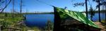

After a bit of a struggle over dinner - M doesn't like mashed potatoes but I'd thought I could get away with fancy mashed potatoes late in a trip, and it turns out I couldn't - the sun started setting. Sunset in the burn zone is perhaps the most beautiful of anywhere in the BWCA, as the sunset stretches across the entire horizon almost unhindered. We actually had a 360 degree sunset briefly, which I couldn't capture with my phone camera (unfortunately M's GoPro was dead by this point), but here are some pictures I got: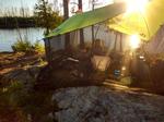


And here are some more that M took, you can see she has a more artistic eye:


We slept with views of water out both sides of our tent, and cool breezes blew through all night long, making for a fabulous sleep.
~Insula, Lake, Hudson Lake
Now into the big water, easy-paddle portion of the trip, we had plenty of time to cover the small remaining distance so our goal for Friday was modest - simply cross Insula. But we still wanted to get on the water early while it was calm, as Insula was perhaps the biggest water we'd cross on this trip. We got up, broke camp, ate a Clif bar, and were on the water by 7:45. As we first left camp, the water was like a mirror; as we passed through the channel onto the main body of Insula there were some small ripples on the water, but it remained calm, and the day was gorgeous. Especially after all the wind and all the traffic the day before, it seemed almost surreal to be in complete solitude and complete calm as we paddled south.
We made really good progress south, and we'd only been going about 45 minutes when - right by "The Rock" - the terrain radically changed as we entered the burn zone of the 2011 Pagami Creek fire. I'd only experienced the foreign landscape of the burn zone for the first time in May on a BWAC trail clearing trip on the Pow Wow Trail; for M, this was the first time in a burn zone, and she was struck by the strangeness of it.
Before our trip my wife had encouraged me to get a PLB of some sort, and part of the reason I decided to get one and chose the InReach Explorer+ was that I was a little concerned about navigating the various islands in the southern part of Insula, and I liked the idea of having a GPS map backup in case we ran into trouble; however, I've always navigated by map (and compass when necessary) and so M and I had resolved to *try* to navigate it without the GPS, and I was pleasantly surprised to find that we didn't have any trouble navigating it. As a parent, I was especially pleased that M's navigation skills had improved so much (thanks in part to Camps Menogyn and Birchwood) that in the couple of instances I wasn't completely sure, she was able to meaningfully assist in navigating. We arrived, without navigational issues, at the west portage off Insula at 9:30 AM and decided that we might as well cross to Hudson before stopping.
The portage from Insula to Hudson has substantial elevation change and at 95 rods it isn't short; and yet it has a reputation for being a spectacular portage, and I think we would agree. Especially because of the burn, it allows gorgeous views in many directions, most notably back toward Insula:
As we were approaching the Insula-Hudson portage we'd seen another person heading down the portage away from Insula, and as we reached the far side of the portage we found six young guys, three boats, and a bunch of gear all over the portage. They apologized for being in my way as I walked through their stuff out into the water, and set down our canoe. I heard one of them say, "That's brilliant - why didn't we think of that" but I have no idea what I'd done that was brilliant. I went back for my half-portage, and as usual M finished her 1.5 before I'd finished my 1.5; by the time I got back they were pushing off into Hudson. She mentioned some things that indicated that they didn't really know what they were doing, and once we were on the water we caught them really quickly, only for me to notice that every one of them was using their paddles backwards! Now, I'm a pretty outgoing person but I also don't like to call people out on stupidity; I waffled for a while and then asked M's opinion, and she agreed I should say something. So we pulled alongside them and mentioned as politely as possible that they were using their paddles backwards, and showed them how you're supposed to do it. The guys in the canoe right there laughed, one said "oh my god" and the other said, "where were you two days ago?" They then spread the news to their other boats, and they commented how much more useful the paddles were. I was glad they took it well. But it left me wondering what kind of outfitter hands out bent-shaft paddles to people who clearly aren't from northern canoe country without explaining to them which way to use the paddle - in the south people only use straight paddles, and it's hard to fault them for not knowing how to use them. Shame on the outfitter for not explaining.
Anyway, we were now paddling across Hudson Lake and getting hungry, it being about 10:00, so we wanted to find a site. We were deep in the burn zone and all the sites were burn sites, and I became a bit of a Goldilocks trying to find a good site, but M was game and we passed by all the sites on Hudson Lake proper without finding one we liked. The very last site before the first portage toward Lake Three was already taken, so we looped back to the site immediately before it, site 1376, pulling up on the landing at 10:30 after 8 miles of paddling. Though it wasn't among the best sites we stayed at, it was strikingly beautiful in its post-fire recovery, and we took several photos and videos of the site throughout the day. Some right after arrival:
It was still morning when we arrived, of course, and we hadn't had breakfast, so we did one of the things I love more than anything - we fixed breakfast after arriving at our new site. We had biscuits and gravy, bacon, and coffee, and even though there was no protection from the sun and the day was getting quite warm, the coffee was delicious.
With breakfast so late we decided to skip lunch, filtered a whole lot of water, and took the only sun shelter we could get in the burn zone, our Nemo Bugout bug shelter. The point of the site was exceptionally windy, and the ground was quite rocky, so we did have a bit of a struggle getting the tarp to stay put; apparently the wind exceeded the design specs from Nemo, as we did get a rip at one of the ridge tie points, but the shelter did its job and we had a good day of dodging the sun and the wind. I still managed to get a wicked sunburn, even with the shelter and plenty of sunscreen; it's hard to even imagine how exposed to the elements you are in the burn zone.
After a bit of a struggle over dinner - M doesn't like mashed potatoes but I'd thought I could get away with fancy mashed potatoes late in a trip, and it turns out I couldn't - the sun started setting. Sunset in the burn zone is perhaps the most beautiful of anywhere in the BWCA, as the sunset stretches across the entire horizon almost unhindered. We actually had a 360 degree sunset briefly, which I couldn't capture with my phone camera (unfortunately M's GoPro was dead by this point), but here are some pictures I got:
And here are some more that M took, you can see she has a more artistic eye:
We slept with views of water out both sides of our tent, and cool breezes blew through all night long, making for a fabulous sleep.
~Insula, Lake, Hudson Lake
Part 8 of 9
Saturday, July 7 - Day Six
We now had two days of paddling and only about ten or eleven miles left to go, but since part of that distance was Lake Three, and since Friday's early-morning paddle had gone so well we decided we'd like to get an early start. Our goal was modest - just get across Lakes Four and Three - so we figured we'd do the same thing as the day before, and eat breakfast on arrival. We got up before six, ate some granola bars, and were pushing off by 6:30.
The first portage was quick and easy, a flat little 17 rod job. The second portage, listed as 25 rods, was not; my best guess is that in the fast post-burn regrowth the original portage was obscure enough that people started taking a false portage that began looking enough more convincing that several people took it until, from the south side, the false portage looks more like the portage than the original portage. This other portage is the one we took, and by my estimate it was probably about 60 rods, which isn't so bad except that it was terribly overgrown, and had several down trees along its path. It was too tight to turn around in, so once you're committed with a canoe, you're committed. It was also too tight to maneuver the canoe, and at several spots I had to bring the canoe down, pull it through, then pick it back up. We got everything through the portage without issue, but it was slower and far more difficult than it should have been. From the north side of the portage of course, the original portage trail was abundantly obvious; coming from the north nobody would catch the wrong trail, but from the south it's a different story.
Even with the struggle on the second portage, we were through all three portages (the third one is also easy, though a little tricky to find) by 7:30 and heading out toward Lake Four, where we saw a family of ducks out for a swim.
As we went out onto Lake Four the wind was significant but not too bad so we decided to take the shortest route to the islands separating Lake Four from Lake Three, which took us right across the center. Lake Four is pretty small and relatively protected, so this wasn't too difficult. We went around the north edge of the islands to enter Lake Three, which put us directly against the wind as we entered the lake in a very shallow, rocky spot, but fortunately we didn't have any issues. Lake Three itself was quite windy, even at 8:00 AM, and although there were several available sites near where we'd planned to stop, we decided they would all be far too windy later in the day; the one protected site on the Lake Three side of the channel into Lake Two was already taken so we decided to just cross onto Lake Two - with a spoken agreement that we didn't want to have to backtrack, but that we *weren't* going to leave the Boundary Waters today, especially since we still had a Trailtopia dessert in the bear vault! It wasn't quite 9 AM and we were both pretty hungry, looking forward to a big breakfast. We had our eyes on the site jutting north from the peninsula on the southern shore just northwest of the entry from Lake Three (site 1525) and I got a first inkling of what was going to be a significant problem: we were only one lake in from the easiest, most popular paddle-only entry in the BWCA, and we were so early in the morning that nobody had broken camp yet, so even if the sites were *going* to be available, they weren't available yet. We ended up doing basically a complete circle of the lake, checking all the sites and taking about 45 minutes before ending up at the far western edge, at the most southwestern site (site 1523) in the lake. We arrived at 9:30 AM, having paddled 7.5 miles. We were both annoyed by the delay because we'd had visions of cinnamon fry bread dancing in our heads since Lake Four, but it ended up being a good thing for several reasons: first, the site wasn't nearly as heavily used as most sites in this area, so it wasn't worn out; second, being on a jutting peninsula, it had water on three sides and lots of options for sun, shade, wind, windbreak, rock, dirt, trees, etc. Third, despite being on a heavily traveled lake, it was fairly secluded. Finally, and importantly the next day, the site was close to the portages to Lake One. But I'll get to that later. For now, we were hungry, and after quickly scoping the site we decided to ignore the primary fire grate area since it was getting pounded by wind, and instead we set up our camp in a north-facing clearing that was really the site's only good tent pad. We went all out on our last camp breakfast - eggs, bacon, spam, cinnamon fry bread, coffee.
After breakfast we quickly came to recognize one of this sheltered tent spot's serious flaws - it completely blocked the wind, and since the storm on Wednesday, this was our first seriously humid day as the humidity was rising for another storm, so we were HOT! We did play some cards since it was so well sheltered from the wind: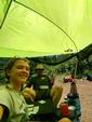
but by lunch time it was too hot so we went out on the south-facing rock face near the kitchen area, ate our salami and gouda, and lay on the rock and read for several hours: I was reading Gary Paulson's Winterdance, and M was reading Douglas Adams' Restaurant at the End of the Universe.
Dinner was Trailtopia Chili Mac, followed with the traditional last-night dessert of Trailtopia Apple Crisp, an absolute favorite of ours. After dinner we saw a family of loons out on the north side of the site, with the parents appearing to be teaching the juniors how to fish, dive, and do all the basic loon activities. We sat and watched them for probably a half hour, and eventually they swam off.
A quick check of the weather forecast on the InReach showed rain all morning and a very high chance that we'd wake up in a rain storm, so we decided to keep our early mornings rolling. Additionally, with just two small portages to go and a good chance we'd be doing them in the rain, M decided that she really wanted to single-portage them instead of the 1.5-portage we'd been doing. So she and I packed everything except our tent and our sleeping gear, being careful to put all the remaining weight in the Guide pack that M would carry, and filling the Pioneer pack with light items that I could carry along with the canoe. It was very humid, and out on the point the wind was whipping up, but the sky was clear, so we went to sleep with all the tent's guylines secured but the tarp fully open, so I could zip it up quickly when/if the rain started and we'd be ready for whatever came.
~Hudson Lake, Four, Lake, Three, Lake, Two, Lake
We now had two days of paddling and only about ten or eleven miles left to go, but since part of that distance was Lake Three, and since Friday's early-morning paddle had gone so well we decided we'd like to get an early start. Our goal was modest - just get across Lakes Four and Three - so we figured we'd do the same thing as the day before, and eat breakfast on arrival. We got up before six, ate some granola bars, and were pushing off by 6:30.
The first portage was quick and easy, a flat little 17 rod job. The second portage, listed as 25 rods, was not; my best guess is that in the fast post-burn regrowth the original portage was obscure enough that people started taking a false portage that began looking enough more convincing that several people took it until, from the south side, the false portage looks more like the portage than the original portage. This other portage is the one we took, and by my estimate it was probably about 60 rods, which isn't so bad except that it was terribly overgrown, and had several down trees along its path. It was too tight to turn around in, so once you're committed with a canoe, you're committed. It was also too tight to maneuver the canoe, and at several spots I had to bring the canoe down, pull it through, then pick it back up. We got everything through the portage without issue, but it was slower and far more difficult than it should have been. From the north side of the portage of course, the original portage trail was abundantly obvious; coming from the north nobody would catch the wrong trail, but from the south it's a different story.
Even with the struggle on the second portage, we were through all three portages (the third one is also easy, though a little tricky to find) by 7:30 and heading out toward Lake Four, where we saw a family of ducks out for a swim.
As we went out onto Lake Four the wind was significant but not too bad so we decided to take the shortest route to the islands separating Lake Four from Lake Three, which took us right across the center. Lake Four is pretty small and relatively protected, so this wasn't too difficult. We went around the north edge of the islands to enter Lake Three, which put us directly against the wind as we entered the lake in a very shallow, rocky spot, but fortunately we didn't have any issues. Lake Three itself was quite windy, even at 8:00 AM, and although there were several available sites near where we'd planned to stop, we decided they would all be far too windy later in the day; the one protected site on the Lake Three side of the channel into Lake Two was already taken so we decided to just cross onto Lake Two - with a spoken agreement that we didn't want to have to backtrack, but that we *weren't* going to leave the Boundary Waters today, especially since we still had a Trailtopia dessert in the bear vault!
It wasn't quite 9 AM and we were both pretty hungry, looking forward to a big breakfast. We had our eyes on the site jutting north from the peninsula on the southern shore just northwest of the entry from Lake Three (site 1525) and I got a first inkling of what was going to be a significant problem: we were only one lake in from the easiest, most popular paddle-only entry in the BWCA, and we were so early in the morning that nobody had broken camp yet, so even if the sites were *going* to be available, they weren't available yet. We ended up doing basically a complete circle of the lake, checking all the sites and taking about 45 minutes before ending up at the far western edge, at the most southwestern site (site 1523) in the lake. We arrived at 9:30 AM, having paddled 7.5 miles. We were both annoyed by the delay because we'd had visions of cinnamon fry bread dancing in our heads since Lake Four, but it ended up being a good thing for several reasons: first, the site wasn't nearly as heavily used as most sites in this area, so it wasn't worn out; second, being on a jutting peninsula, it had water on three sides and lots of options for sun, shade, wind, windbreak, rock, dirt, trees, etc. Third, despite being on a heavily traveled lake, it was fairly secluded. Finally, and importantly the next day, the site was close to the portages to Lake One. But I'll get to that later. For now, we were hungry, and after quickly scoping the site we decided to ignore the primary fire grate area since it was getting pounded by wind, and instead we set up our camp in a north-facing clearing that was really the site's only good tent pad. We went all out on our last camp breakfast - eggs, bacon, spam, cinnamon fry bread, coffee. After breakfast we quickly came to recognize one of this sheltered tent spot's serious flaws - it completely blocked the wind, and since the storm on Wednesday, this was our first seriously humid day as the humidity was rising for another storm, so we were HOT! We did play some cards since it was so well sheltered from the wind:
but by lunch time it was too hot so we went out on the south-facing rock face near the kitchen area, ate our salami and gouda, and lay on the rock and read for several hours: I was reading Gary Paulson's Winterdance, and M was reading Douglas Adams' Restaurant at the End of the Universe.
Dinner was Trailtopia Chili Mac, followed with the traditional last-night dessert of Trailtopia Apple Crisp, an absolute favorite of ours. After dinner we saw a family of loons out on the north side of the site, with the parents appearing to be teaching the juniors how to fish, dive, and do all the basic loon activities. We sat and watched them for probably a half hour, and eventually they swam off.
A quick check of the weather forecast on the InReach showed rain all morning and a very high chance that we'd wake up in a rain storm, so we decided to keep our early mornings rolling. Additionally, with just two small portages to go and a good chance we'd be doing them in the rain, M decided that she really wanted to single-portage them instead of the 1.5-portage we'd been doing. So she and I packed everything except our tent and our sleeping gear, being careful to put all the remaining weight in the Guide pack that M would carry, and filling the Pioneer pack with light items that I could carry along with the canoe. It was very humid, and out on the point the wind was whipping up, but the sky was clear, so we went to sleep with all the tent's guylines secured but the tarp fully open, so I could zip it up quickly when/if the rain started and we'd be ready for whatever came.
~Hudson Lake, Four, Lake, Three, Lake, Two, Lake
Part 9 of 9
Sunday, July 8 - Day Seven
I woke up very early - before 5 - and noticed it wasn't raining and things weren't wet. Resisting the urge to get up just then and get on the water before any weather hit, I tried for almost an hour to get a little extra sleep. Some time before 6 M also woke up, and we agreed we might as well get packed up. With everything organized and packed, and without eating any breakfast, we pushed out for the exit at 6:30.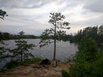

Our trip last year ended with a thunderstorm hitting for the last bit of paddle to the exit point, and so we were prepared for history to repeat itself, with our rain jackets on as we paddled. The sky to the southeast looked ominous, but we were paddling north and the sky to the north looked pretty good; unfortunately, the wind was blowing from the south and we expected the storm to catch us. Just as we approached the first portage to Lake One it started raining, and we assumed we'd be in it. We landed, M took off with the heavy pack and paddles, and I took the light pack and canoe, and we covered the portage. I'd forgotten how wide and flat these two portages are, more like a state park than the wilderness. By the time we reached the end of the first portage the rain had actually stopped, and we realized we'd caught a bit of luck. Short paddle to the second portage, single portage across, and we were on Lake One.
The sun even kind of peeked out of the clouds to the east as we paddled Lake One; the sky to the south continued to be gross, but it was relatively calm and almost pleasant on Lake One. It's been over 15 years since I was on Lake One - I've avoided it because it's so crowded, overused, and not very wilderness (there's even cell phone coverage!) - but one thing I'd forgotten was how incredibly beautiful it is, especially after having spent so much time in the burn zone. The early-morning calm and the surreal lighting from the approaching storm only served to accentuate its beauty, and we were so early that nobody else was on the water so we could almost forget we were surrounded by people.
Another thing I'd forgotten in the 15 years since I was last on Lake One is that it's actually *not* an easy lake to navigate. It's much easier than Insula, but I'd been hyper-vigilant on Insula, while this morning I was thinking about the weather, the exit, the coffee in Ely, the beauty of the lake, in short everything *but* navigating. As we rounded the island where we intended to go north toward the Kawishiwi River path to the exit, I got myself disoriented by 90 degrees but was completely confident I knew where we needed to go - I didn't bother pulling out my compass or a GPS to double check, because I was sure we wanted to go the direction that was really west, toward the Lake One Dam portage, which I thought was north in that moment. M knew I was wrong, and she laid out her case; after some arguing, I pulled out my compass and discovered she was right - she was sure I was trying to get her to do the portages around the dam, but truth by told I was just unusually disoriented. Regardless, her navigation was right, which helped me not be too embarrassed about having myself been wrong.
As we paddled up to the top of Lake One toward the narrow channel that becomes the Kawishiwi and heads toward the exit, three rental canoes full of six guys started paddling out from a site on the east shore toward the exit. They were disorganized, but were paddling efficiently, and moving only a little slower than we were. They stayed right behind us the whole way up, right behind at the hook near the Kawishiwi Lodge. As we turned on the hook we turned toward the storm, and the sky was dark and ominous. We were so close, I hoped we could make it before the storm hit.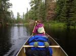
There's a place just before the Lake One entry where a bay on the right looks like it might be the landing, but the channel and the path to the entry are actually more to the left. We paddled accordingly, but the three other canoes took off to the right and for just a moment I had a doubt that we were doing it right. Of course, quickly it became clear they'd fallen for the false landing, and once again they came behind us as we rounded the peninsula and turned toward the real landing.
We reached the landing for Lake One at 8, nearly dry and without incident, after a short 4.2 mile paddle. The three other canoes landed just after us, and M commented that she thought it was the guys we'd seen on Hudson Lake, who'd been using their paddles backward. Sure enough, I heard one of them commenting that we were the paddle people, and we talked and laughed about it. They said they'd had a great trip, that they really appreciated knowing how to use their paddles when they crossed Lake Three, and they really liked the experience. I also overheard one of them comment that they "were probably the most inexperienced people on the beach". Mind, it was a crowded landing with a lot of *extremely* rookie people getting ready to enter, and I almost commented that after five days in the wilderness where they'd gotten all the way to Insula and back they certainly knew more than most of the people at the landing, but figured maybe I shouldn't broadcast that to all the people on the landing. Just as our boats were landing there was an older man and his grandson about to head out, and one of the guys from the other group helped them get going. Given the impending weather and their large amount of gear, I was a bit worried about them, but they headed in as I went to get our car.
I pulled the car around, M and I threw our two bags and paddles in the back, we put the canoe on the roof, and we strapped it down. Just as we were climbing in to change our shoes, the sky opened up. Two large groups and their fleets of aluminum canoes had just been dropped off by outfitters, and the guys who'd landed with us were still waiting for their outfitter shuttle. The guys found shelter under the latrine awning, and the groups about to go in stood on the beach and got wet as we waved and started off toward Ely, dry in our car.
As we drove back to Ely the storm got more and more intense, with hail bouncing off our canoe and car for a good five minutes, but then it lessened again just as we got to Ely. We stopped at Front Porch Café for our now-traditional first coffee and pie out of the woods. Not yet even 9 AM, there was a line of regulars there for breakfast but we found a seat and enjoyed our coffee and pie. After breakfast we went to the Elywear store and got M a sweatshirt, spent a while looking around Piragis to wait out another serious bout of blowing rain, then went over to Northern Grounds for a second cup of coffee while the rain continued. A quick stop at Crapola to pick up some granola, and then we were at Ely Steakhouse for an early lunch of Bucky Burgers. The World Cup was on the TV and we learned from the bartender and patrons that soccer would be a better game if the field were a bit smaller - there were a few less players - they had sticks in their hands - and the ball was replaced with a puck. The lounge is always the best place to be, but on a Sunday morning it's especially great.
Thus reintroduced to civilization, we drove home tired and satisfied after seven days, six nights, six sites, and 55 miles east-to-west across the center of the Boundary Waters.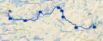
~Two, Lake, One, Lake
I woke up very early - before 5 - and noticed it wasn't raining and things weren't wet. Resisting the urge to get up just then and get on the water before any weather hit, I tried for almost an hour to get a little extra sleep. Some time before 6 M also woke up, and we agreed we might as well get packed up. With everything organized and packed, and without eating any breakfast, we pushed out for the exit at 6:30.
Our trip last year ended with a thunderstorm hitting for the last bit of paddle to the exit point, and so we were prepared for history to repeat itself, with our rain jackets on as we paddled. The sky to the southeast looked ominous, but we were paddling north and the sky to the north looked pretty good; unfortunately, the wind was blowing from the south and we expected the storm to catch us. Just as we approached the first portage to Lake One it started raining, and we assumed we'd be in it. We landed, M took off with the heavy pack and paddles, and I took the light pack and canoe, and we covered the portage. I'd forgotten how wide and flat these two portages are, more like a state park than the wilderness. By the time we reached the end of the first portage the rain had actually stopped, and we realized we'd caught a bit of luck. Short paddle to the second portage, single portage across, and we were on Lake One.
The sun even kind of peeked out of the clouds to the east as we paddled Lake One; the sky to the south continued to be gross, but it was relatively calm and almost pleasant on Lake One. It's been over 15 years since I was on Lake One - I've avoided it because it's so crowded, overused, and not very wilderness (there's even cell phone coverage!) - but one thing I'd forgotten was how incredibly beautiful it is, especially after having spent so much time in the burn zone. The early-morning calm and the surreal lighting from the approaching storm only served to accentuate its beauty, and we were so early that nobody else was on the water so we could almost forget we were surrounded by people.
Another thing I'd forgotten in the 15 years since I was last on Lake One is that it's actually *not* an easy lake to navigate. It's much easier than Insula, but I'd been hyper-vigilant on Insula, while this morning I was thinking about the weather, the exit, the coffee in Ely, the beauty of the lake, in short everything *but* navigating. As we rounded the island where we intended to go north toward the Kawishiwi River path to the exit, I got myself disoriented by 90 degrees but was completely confident I knew where we needed to go - I didn't bother pulling out my compass or a GPS to double check, because I was sure we wanted to go the direction that was really west, toward the Lake One Dam portage, which I thought was north in that moment. M knew I was wrong, and she laid out her case; after some arguing, I pulled out my compass and discovered she was right - she was sure I was trying to get her to do the portages around the dam, but truth by told I was just unusually disoriented. Regardless, her navigation was right, which helped me not be too embarrassed about having myself been wrong.
As we paddled up to the top of Lake One toward the narrow channel that becomes the Kawishiwi and heads toward the exit, three rental canoes full of six guys started paddling out from a site on the east shore toward the exit. They were disorganized, but were paddling efficiently, and moving only a little slower than we were. They stayed right behind us the whole way up, right behind at the hook near the Kawishiwi Lodge. As we turned on the hook we turned toward the storm, and the sky was dark and ominous. We were so close, I hoped we could make it before the storm hit.
There's a place just before the Lake One entry where a bay on the right looks like it might be the landing, but the channel and the path to the entry are actually more to the left. We paddled accordingly, but the three other canoes took off to the right and for just a moment I had a doubt that we were doing it right. Of course, quickly it became clear they'd fallen for the false landing, and once again they came behind us as we rounded the peninsula and turned toward the real landing.
We reached the landing for Lake One at 8, nearly dry and without incident, after a short 4.2 mile paddle. The three other canoes landed just after us, and M commented that she thought it was the guys we'd seen on Hudson Lake, who'd been using their paddles backward. Sure enough, I heard one of them commenting that we were the paddle people, and we talked and laughed about it. They said they'd had a great trip, that they really appreciated knowing how to use their paddles when they crossed Lake Three, and they really liked the experience. I also overheard one of them comment that they "were probably the most inexperienced people on the beach". Mind, it was a crowded landing with a lot of *extremely* rookie people getting ready to enter, and I almost commented that after five days in the wilderness where they'd gotten all the way to Insula and back they certainly knew more than most of the people at the landing, but figured maybe I shouldn't broadcast that to all the people on the landing. Just as our boats were landing there was an older man and his grandson about to head out, and one of the guys from the other group helped them get going. Given the impending weather and their large amount of gear, I was a bit worried about them, but they headed in as I went to get our car.
I pulled the car around, M and I threw our two bags and paddles in the back, we put the canoe on the roof, and we strapped it down. Just as we were climbing in to change our shoes, the sky opened up. Two large groups and their fleets of aluminum canoes had just been dropped off by outfitters, and the guys who'd landed with us were still waiting for their outfitter shuttle. The guys found shelter under the latrine awning, and the groups about to go in stood on the beach and got wet as we waved and started off toward Ely, dry in our car.
As we drove back to Ely the storm got more and more intense, with hail bouncing off our canoe and car for a good five minutes, but then it lessened again just as we got to Ely. We stopped at Front Porch Café for our now-traditional first coffee and pie out of the woods. Not yet even 9 AM, there was a line of regulars there for breakfast but we found a seat and enjoyed our coffee and pie. After breakfast we went to the Elywear store and got M a sweatshirt, spent a while looking around Piragis to wait out another serious bout of blowing rain, then went over to Northern Grounds for a second cup of coffee while the rain continued. A quick stop at Crapola to pick up some granola, and then we were at Ely Steakhouse for an early lunch of Bucky Burgers. The World Cup was on the TV and we learned from the bartender and patrons that soccer would be a better game if the field were a bit smaller - there were a few less players - they had sticks in their hands - and the ball was replaced with a puck. The lounge is always the best place to be, but on a Sunday morning it's especially great.
Thus reintroduced to civilization, we drove home tired and satisfied after seven days, six nights, six sites, and 55 miles east-to-west across the center of the Boundary Waters.
~Two, Lake, One, Lake
Lakes Traveled:
Three, Lake,
Three, Lake,
discuss this trip report (13 comments) - last post on August 06, 2018