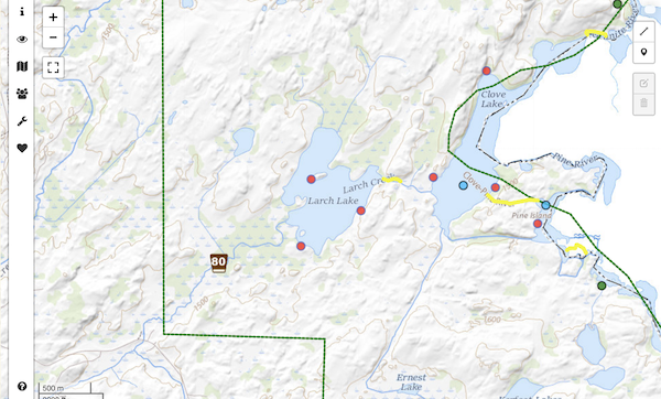
80 - Larch Creek
Permits Available:
1
Entry Type:
Overnight Paddle Only
Ranger Station:
Gunflint - 53 miles from office
Entry Point Notes:
- 1 entry permit(s) granted per calendar day. (May 1st - Sept. 30th)
- Access from the canoe landing at Larch Creek.
- Latitude: 48.12695 Longitude: -90.83039
- Approx. Directions
Interactive Map ( View Map)
Permits
Permit reservations must be made for overnight camping or day use motor in the BWCA. You can make permit reservations through an outfitter or directly. Day use permits for paddling are available at the entry point and do not require a reservation or a fee.
More Permitting Information Find Available Permits
Outfitting/Gear Rental
View OutfittersTrip Reports - Larch Creek
| Trip Name | Type | Days |
|---|---|---|
| Larch Creek + Clove Lake | Paddling Canoe | 4 Days |
| Larch Creek EP80 | Paddling Canoe | 4 Days |
| Larch Creek to Gneiss Lake 7/29-8/1 | Paddling Canoe | 5 Days |
| Larch Lake - May 2016 | Paddling Canoe | 4 Days |
| A first of many??? | Paddling Canoe | 5 Days |
| Blue heaven on the Granite river | Paddling Canoe | 5 Days |
Recent Forum Discussions - 80 - Larch Creek
| Discussion | Forum | Last Post | Date Posted |
|---|---|---|---|
| Larch Creek | Trip Planning Forum | 05-17-2025 | 05-15-2025 |
| Entry point 80 Larch Creek | Trip Planning Forum | 12-02-2024 | 09-06-2022 |
| Sawbill or Larch Creek Entry Point | Trip Planning Forum | 01-22-2023 | 01-22-2023 |
| Larch Creek | Trip Planning Forum | 05-17-2022 | 05-17-2022 |
| Larch Creek EP80 | Trip Planning Forum | 08-16-2021 | 06-12-2021 |
| Larch Creek EP 80 water level | Trip Planning Forum | 07-03-2021 | 07-03-2021 |
| EP80 Larch Creek/ Granite River heading North to Sag Falls | Trip Planning Forum | 08-20-2020 | 08-20-2020 |