BWCA Entry Point, Route, and Trip Report Blog
April 27 2024
Entry Point 77 - South Hegman Lake

Number of Permits per Day: 1.5 (varies by day)
Elevation: 1282 feet
Latitude: 48.0336
Longitude: -91.9250
South Hegman Lake - 77
The historic pictograph route
Entry Date:
September 27, 2014
Entry Point:
South Hegman Lake
Exit Point:
Wood Lake (26)
Number of Days:
8
Group Size:
2
Finding our bunkhouse last night proved to be a bit confusing. Still, we incurred no major setbacks, sitting out and enjoying the wondrous Milky Way & star filled sky before turning in for a good night sleep.
A quick hearty breakfast & we were off to Spirit of the Wilderness Outfitters to pick up our permit, then shuttle our vehicle to the Wood Lake (EP #26) parking lot. From there, our driver Nick shuttled us to our entry point, South Hegman Lake (EP #77). After unloading, we took a couple of photos beside the kiosk in the parking lot before officially embarking on our adventure.
As expected, the trail was in great shape and easily traversed. The only discernible impediment along the way was the stairway leading down to the shores of South Hegman Lake. Don’t get me wrong, the stairs were preferable to the alternative. It’s just that the steps were built for someone with size 48 feet. It required a step and a half on each stair, which, for me, proved to be an unnatural - uncomfortable stride. Vickie told me my legs were just too long.

It was shaping up to be an absolutely gorgeous day, as temperatures would approach the eighties later in the day. There was a tranquil cooling breeze easing across the lake as we worked our way towards our first portage.
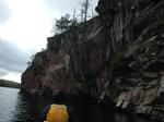
Although the portage into North Hegman Lake wasn’t too much more than a pullover, it provided a scenic backdrop while we quickly accomplished the task. Indeed, we would rate both Hegmans as eye-catching lakes.
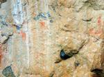
For most people, as well as us, the undeniable attraction of North Hegman Lake is the excellent pictographs that are located along the western shore. In fact, they were the major reason why we chose this entry point. Situated in a narrow arm of the lake, we had no difficulties locating these pictographs. We took pause - marveling & reflecting on their possible meaning; wondering who may have created them, and why?


There was an interesting article in The Boundary Waters Journal awhile back. In it, the authors’ theory about these pictographs was that they represented some familiar constellations. I can offer nothing to either, confirm, nor deny the wisdom of that logic, but it is a fascinating explanation.
Soon, the wood was back in the water as we paddled; still fueled by first day adrenaline, up through tiny Trease Lake on to our next portage.
Initially we erroneously pulled up to an alternate landing just west of the actual (more convenient) landing. There was a short trail connecting the two landings. But, once we discovered the error of our ways, we paddled over to the proper landing. We certainly didn’t want to add any more length to this already formidable portage.
Somewhat surprisingly, the trail was well worn & open. I surmised several people hiking the Angleworm loop must also traverse this spur trail to add some variety, thus keeping the trail packed down in the process. For us, our game plan was to leap frog this long portage. About ¼ of the way through, we encountered the foreboding mud hole. Fortunately, for us, it had been relatively dry recently. Still, getting the canoe through this section proved to be incredibly taxing; since it was difficult, if not impossible, (because of the overhanging trees & brush) to skirt the edges where there was significantly better footing. So, while carrying the canoe, I wound up plodding right through the middle of the ankle to calf deep mud. Crossing through this corridor of muck & mire warranted our first ‘pose’.

With a little less spring in our step, we continued on.
Just past what we presumed to be the half way point, returning for my second load, I was TOTALLY flabbergasted to run across a mother & daughter following behind us. They too were doing the portage, and their husband/father was just behind with the canoe. Though I never asked, the scant amount of gear they were carrying clearly indicated to me that either they were just on a day trip, or were the most accomplished, Spartan campers I’ve ever run across.
At first, I must admit, I was a little discouraged by having to share the portage with another group. But, they were an extremely friendly family and inadvertently provided some comic relief; helping to take our minds off the drudgery of the task remaining.
Each time, returning for my other load, when I’d cross paths with them, they’d enthusiastically ask, “Did you see the lake yet?!?” Believe me, I didn’t want to have to let the air out of their balloon, but, reluctantly, I had to say “no” multiple times. However, in a sad twisted way, this recurrent scenario would eventually bring a smile to my face.
Although this was one of the tougher trails I’ve done in the BWCAW, one of the aspects I always enjoy about doing longer portages is the opportunity to see multiple facets of the forest ecology. And, much like most other longer portages, this one didn’t disappoint. As we passed through the varied rolling terrain, most of the deciduous trees were sporting their fall plumage, and the beams of sunlight perpetually penetrating the forest canopy highlighted those displays in spectacular fashion.
Autumn is absolutely my favorite season for canoe country travel for just that reason. While summer travel has its charms, the greens of the plants and trees seem to meld everything together. In fall, there’s more of a sense of individuality in the woods. For example, above and beyond the inherent beauty they exude; the bright red glow of a maple tree, or the golden shimmer of birch leaves make them instantly recognizable – even from across a lake.

By the time we reached the Angleworm trail junction, the family we were sharing the portage with had over taken us. Shortly afterwards, each having taken a different fork, they temporarily became separated. We intermittingly ran across each of them and advised them to return to the junction and just stay put. Happily, they were soon reunited.
Angleworm is a lake that requires substantially more work to get to than virtually any other BWCAW entry point. Consequently, the logical perception would be that people would shy away for just that reason. Well…..today wasn’t one of those days. Besides the family we shared the portage with, there were no less than 3 other separate hiking groups on the Angleworm Trail. And, those were just the ones that we seen! Undoubtedly people were taking full advantage of the beautiful weekend weather.
Exhausted, we put in on Angleworm Lake shortly after the family & continued our journey northwards, hoping that a greater sense of solitude would be achieved.
Perhaps biased by the effort it took to get here, both of us agreed Angleworm was an exceptionally scenic lake. All along the lake were conifer capped cliffs with knobby granite precipices & fingers running down to the water. At one time there was a fire tower, sawmill, and even an old railroad line running to this lake. It would’ve been fun to check out what was left of those old spots, but we needed to keep paddling on.

Angleworm Lake eventually morphs into more of a river-esque paddle on the north end. In slightly higher water, I believe we would’ve been able to paddle through the first beaver dam & rocks we encountered. As it was, we had to take the short portage (5 rods??).
A quick snack break & we were back on the water, but not for long. Here we came to the portage into Home Lake. It starts, at the base of a long standing beaver dam, with a short climb & some minor twists and turns before eventually straightening out and dropping us on Home Lake. Looking back, it may have been wiser to just do this whole section in one long portage.

From a distance, the eastern campsite on Home Lake (which was open) looked attractive and quite enticing as we wearily paddled by. Though both of us were tired, a unanimous decision was made to push on to Gull Lake as planned.
It was getting late…. The hiking trail intersection added some temporary confusion but, we managed to get everything across without serious incident or delay. For a ¾ mile portage, I thought this one was relatively decent. As I recall, only one rocky, gradual downhill (going towards Gull) section that even warrants mentioning. Considering how long a day it’d been for us already, I’d say that equates this portage to a walk in the park.
We lingered on the granite knob at the Gull Lake landing to collectively catch our breath; and, since there wasn’t going to be much daylight left once we got to camp, establish the immediate game plan for when we landed. By the way, this landing wasn’t the most user friendly!
When we pulled into camp, the sun was just dropping over the horizon. Captain William Clark’s famous quote; “O! The joy!” succinctly summed up our collective sentiment.

Both of us were completely whipped! Originally we had planned to have fresh pork chops for supper. Fortunately they were still frozen solid, and besides, I was in no mood to search for firewood, much less process it and get a proper cooking fire going. So, Vickie set about making some Alfredo noodles & foil pouch chicken (the quickest pot to plate meal we had along) while I got the tent & our sleeping bags/pads setup.
We ate our lantern light supper under a dazzling star filled sky. With no bugs out, we stayed up a short while reveling in the days adventures, equally proud as thankful in our accomplishment of having reached Gull Lake today. I would’ve thought if sleep was ever going to come easy, this would be the night. Ironically, we both complained how hot & humid it was in the tent. While we enjoyed the unseasonably warm weather of the day, it took awhile for it to cool down inside our Hilleberg tent. But, in the end, we both succumbed into a well deserved deep sleep without too much tossing & turning.
Daily travels – 6 portages totaling 845 rods
South Hegman Lake, North Hegman Lake, Trease Lake, Angleworm Lake, Home Lake, Gull Lake

With our late arrival last night, it should go without saying that we had haphazardly set camp up. So, before breakfast, I got our CCS tarp up, found some firewood and finished getting camp situated while Vickie prepared breakfast.
We definitely weren’t setting any speed records after breakfast but, in due course, we were ready to embark on our day trip loop. The Gun Lake portage was a short paddle east from our campsite. There were some boulders to avoid as we neared the landing where there was a slightly submerged old rock crib dock. This was a short, flat trail that dropped down to a reasonably decent landing on the Gun Lake end.
Tracing the northern shoreline in an eastern direction we paddled past the campsite (that didn’t overly impress either of us) located there. Shortly after, we pulled off where Vickie noticed some shoreline rocks that she felt required a closer inspection.
Continuing on down the ‘barrel’ we came to the Bullet Lake portage. It was another short trail, but the path, and especially the landing, was very rocky. As we approached the Narrows of Bullet Lake, navigable water was in short supply. Soon we stalled out. In hopes of proving my gallantry, I warily climbed out and began dragging the canoe through the slop, hopping from hummocks to hummocks. Having made it most of the way through, I attempted to position myself for one last pull & then a successful re-entry. It was then and there that my entire right leg disappeared in an instant!

Of course Vickie nearly flipped the canoe laughing. And, apparently having shaken the sluggishness of this morning - was lightening quick with her camera. Fortunately I was able to successfully extract myself (boot intact) without assistance, and re-enter the canoe, albeit quite a bit muddier, to continue our journey. We paddled onwards to the Moosecamp portage which was another short trail that was quite ‘soft’ on the Moosecamp Lake end. With Bullet Lake mud still fresh on my mind, as well as my pants leg, I took extra precautions here.
A couple of other canoes were seen fishing as we paddled up to the unoccupied campsite near the mouth of the Moosecamp River to take a break. The first people we’d seen since Angleworm Lake yesterday.
This was once the location of an old logging camp, and there is an array of old logging artifacts or, depending on your perspective, junk, in & around this campsite. Even the log seating around the fire grate is held in place by some old iron that was left behind. Still, I felt this was a very nice campsite that had a lot going for it.

Rested & content with our explorations, we pushed off up the Moosecamp River. All along the river banks were tell tale reminders from the logging era. Large logs with holes in them were scattered all along this stretch of river. If you looked close enough, some of them still had chains attached.

The river was exceedingly weedy and shallow at this end. So shallow, in fact, that I’m not sure we would’ve made it through fully loaded. We discussed the wisdom of continuing on. I’d been through here on other occasions during higher water, and recalled this condition existing in this section back then. I was confident we’d be able to float/paddle all the way to Fourtown Lake. Hopefully I wouldn’t have to eat my words!
Thankfully the river proved to be navigable the entire distance. Though, despite the heat of the day, I must admit there were some sections that made me sweat more than just a little.

As this report should clearly exhibit, Vickie is quite a trooper when it comes to the trials & tribulations that are associated with travel through canoe country. I couldn’t hope for a better tripping partner. But, of course no one is perfect. Vickie’s Achilles heel is dealing with mud & muck; most especially in a river or lake setting. And, the maddening succession of beaver dams we encountered on the upper section of the river tested her mightily each time we needed to hop out and pull through. She couldn’t seem to appreciate the fact that the dams were actually helping maintain floatable water levels.
I tried to soothe her psyche by informing her that the impressive cliffs & escarpments we were paddling past meant we were nearing Fourtown Lake. Sure enough, the lake was soon in sight. Emerging from a swampy lowland like we did; made the expanse of Fourtown Lake unfolding before us, seem all the more striking. We paddled over to the campsite on the north side of the large peninsula directly south of the river’s mouth to take a break.
Fourtown is a very beautiful lake. But, it is a late comer as far as canoe country is concerned. It didn’t achieve protected (non motor, floatplane etc.) status until the late seventies. According to an old Boundary Waters Journal article, there were even cabins on the south end of the lake that weren’t dismantled until 1982. Not to mention the obvious logging activity that occurred in the vicinity. To be sure, Fourtown is a lake with an interesting history.
After recharging a bit, we paddled down the lake in hopes of checking out the campsite on the south end of the lake with the old automobile & artifacts. There were a few people out & about on Fourtown, and unfortunately that campsite was occupied, so we didn’t feel comfortable going ashore there.
We did pull off at the site just west of there, only to find it in total disarray. It looked like it could be a fairly decent site but, the fire grate had been ripped up & there was unburned garbage where the fire grate had been. The garbage was one thing, but ripping up the fire grate, really made us scratch our heads. We soon pressed on.
Later, as we headed towards the Boot Lake portage, small waves were forming as the wind was slowly gaining some momentum. I always enjoy the view looking back at Fourtown Lake from this portage landing; so once there, we spent a few extra moments appreciating this scene. Once on the other side, we could clearly see a weather front moving in. About the time we rounded the ‘ankle’ of Boot Lake, sporadic rain showers began falling. Most of the campsites were occupied, so pulling off wasn’t really an option. Luckily, the wind wasn’t blowing that bad.
By the time we reached the portage to Fairy Lake, a good old soaker had began in earnest. We each donned our rain gear, and then shared a blueberry bagel before resuming our journey.

Emerging from the woods to the Fairy Lake landing, we were startled to see the wind had really begun to howl. The only saving grace was that it wasn’t a cross wind. Paddling Fairy was a blur. It was a pins & needles - rain in your face - crossing, so we just kept our heads down & paddles in the water. Providentially; by the time we reached the shores of Gun Lake, we were given a reprieve. It even quit raining half way across. From there it was a misty, though thankfully uneventful, paddle back to our Gull Lake camp.
For supper tonight, we decided to try the Zatarains’ Jambalaya. Since we forgot to buy the Andouille sausage until the drive up - obviously we didn’t have time to freeze it. So, while the pork chops & ribeyes were still frozen, we thought we’d better eat this first. And, since we had an extra sausage link, Vickie figured she could cut up some potatoes & onions and then add the extra left over sausage to it for breakfast tomorrow morning.
The dehydrated shrimp could’ve used a bit more rehydration time, but the total lack of leftovers proved the Jambalaya was, unequivocally, a smashing success. Not long after supper a gentle rain returned; accompanied by a cool north wind, prematurely chasing us to the protective safe haven of the tent where we each read for awhile before officially retiring for the night.
Daily travels – 7 portages totaling 226 rods.
Gull Lake, Gun Lake, Bullet Lake, Moosecamp Lake, Moosecamp River, Fourtown Lake, Boot Lake, Fairy Lake

A cold, misty morning greeted us upon exiting our warm sanctuary. A little extra TLC was required to get the fire to take off. I headed out to find some more firewood before breakfast was ready. As I was hacking up some downed trees, I inadvertently stirred up a ground hornets’ nest. Their nest was at the base of a downed spruce tree. Thankfully, I was at the other end sawing when I noticed the cloud; thus escaping unscathed. I’m sure the cool temperature kept their hostile activity to a minimum as well.
Originally, our plan for today was a trip to explore some of the Beartrap River. Since it was so cold & gloomy, we decided to stick close to camp today. Besides, the past 2 days had been particularly active, so an undemanding itinerary for today was fairly easy to talk ourselves into.
After breakfast, Vickie headed out to do some exploration, while I stayed in camp to process the firewood I’d dragged back earlier.
Even though we had the lake to ourselves, it was far from quiet. Ironically, I must admit, the Canadian goose (or bustard, as the Voyageurs called them) was not a bird I had seen frequently in canoe country. Well, I think it’s safe to say, we seen more geese today than we had in all previous trips combined. Huge flocks, heading south, passed over throughout the day. At times, the clamor they created was deafening.
 By this time our campsite had really grown on us. Perhaps the coolest thing about it was the long solid rock ‘pier’ jutting out towards the south. This afforded us a commanding multi-directional view of the lake, as well as providing an excellent canoe landing. And, since there was a nice drop just out from shore, it was also a good spot to do some fishing from. Enclosing the fire grate was an assortment of excellent (planed flat) log seating. These also served well as mini tables to hold kitchen items when necessary. Though somewhat open, there were still enough sizeable trees to provide shelter, canoe storage & viable tarp options. There were multiple large, flat tent pads, and even the latrine was about the right distance from camp on a very nice trail.

On the downside, the fire grate didn’t face out towards the lake. And though the tent pads were awfully large & flat, it was a chore trying to find enough soil or even a spot where you could stake the tent down. But, categorically speaking, the most disconcerting aspect of this site was the number or stumps (from trees that were obviously alive when cut) peppered in and around the site.
Certainly, if you look hard enough, you’ll find a few of these at most sites. But, it was the sheer volume that was so astonishing. In some areas it looked like people were trying to clear cut a section of the woods. In my opinion, this was substantially over the top.
Well we didn’t come all this way to dwell on such things, so Vickie suggested we go out for a leisurely paddle around the lake. I grabbed the canoe & fishing poles and away we went.
I told Vickie that with this cold front having just moved in, fishing would likely be slow. On the one hand thinking, that by relaying this information, she’d be impressed with my vast knowledge & prowess as a fisherman, while on the other, laying the groundwork for a viable reason ( i.e. excuse) as to why we weren’t catching anything.
Vickie’s’ first cast was less than textbook. I sarcastically quipped, “Hey, that’ll probably bring you good luck.” So fittingly, even though our Voyageur maps had indicated that only northern pike were present, a short 15 minutes later she was ¾ of the way to the canoe country grand slam! If only Gull Lake held lake trout! 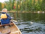


The fishing was fast & furious. We never caught anything huge, but were afforded multiple canoe country doubles. In fact, even though we had the lake to ourselves, the fishing was so good that we attracted an attentive audience.

A dignified bald eagle keenly watched the activity from its’ lofty perch, undoubtedly hoping that one of the fish we released would linger on top of the water so it could swoop in for an easy meal.
Trolling around the lake, we passed closely by each of the other sites located on this lake. In my opinion these sites each appeared to be 2 stars at best. So we most definitely felt we had made the proper choice when choosing a camp. From our enlarged perspective out on the water, we also noted an eagles’ nest atop an old craggy white pine at the portage landing to Home Lake, and paddled past a distinctive rock outcropping jutting up out of the eastern shoreline. There was even a small island which proved to be closely guarded by northern pike!
Though we had caught more than enough fish for a meal, we released everything because we still had plenty of fresh meat back in camp, and we considered it necessary to start making a dent in that supply. I didn’t realize it at the time, but Vickie informed me of the fact that these were the first walleyes she’d ever caught in canoe country. This, of course, made our afternoon all the more memorable.
Back in camp I got a fire going to establish some good grilling coals, while Vickie prepared the potatoes and began re-hydrating the vegetables. Later, as we enjoyed yet another exquisite meal under the comfort of our CCS tarp, a short rain shower fell. By the time the dishes were done, the rain had stopped. I loaded up the fire with an armful of fresh wood; we sat up, thoroughly enjoying the quiet, rain free evening. There was even a little reddish color in the sky at sunset. This would prove to be our latest night of the whole trip, and we savored every second.

Gull Lake
Today we would push on to our next camp. Weather wise, it started out much the same as yesterday. A quick hot oatmeal breakfast got us going, before having to rip everything down.
Our first leg of the day retraced our day trip (of 2 days prior) down the ‘barrel’ of Gun Lake, where the portage to Wagosh Lake started within eyeshot of the Bullet Lake landing.
This trail was in great shape. There were several sections that were incredibly wide and appeared to be an old road, complete with ruts on both sides. I’ve read that portions of this trail are rumored to have been part of the illegal road that was established in the 1950’s by the resort owners on Crooked Lake to counter the air ban. Once you’ve traveled down this trail, it’s hard to imagine an alternative explanation.
Anyone who has ever read anything by Sigurd Olson knows the essence of his works deal with how a wilderness setting can best help man reconnect with natural rhythms that are increasingly difficult to find in our ever urbanized society. For me, undertaking long portages like this, deep within the wilderness, is a sure fire way to make that connection. Starting out, my only thoughts are of the other side. But, as I traverse the trail, I quickly become transfixed on my surroundings. The far off chatter of a squirrel, birds calling across the forest, the rustling of leaves as the wind passes by, the invigorating aroma of autumn….. In and of themselves, they are all just ordinary occurrences. Yet, somehow in this simple setting, they now all take their place front and center. Each to be contemplated & appreciated with amazed wonderment.

After completing the portage, we thought we’d paddle over to the campsite and take a quick snack break. Upon inspection of the steep landing, Vickie promptly vetoed that idea. Besides, there was a foul stench emanating from the lake; so, instead, we paddled for the Niki portage.
For those that use Voyageur maps, Wagosh Lake is a cutoff point where you will need to switch maps. Out on the lake, I attempted to make this change. I set the new map on top of the pack (half opened) while I folded the old one up. Of course a brisk gust of wind came up and blew the new map into the lake. Before we could recover it, it sank to the bottom. I always carry a spare National Geographic map & Vickie still had hers, so it wasn’t a big issue in that sense. Still, I kicked myself for having made such a rookie mistake.
Crossing the lake, we couldn’t help but notice something bright white moving on the other side of the lake very near the Niki portage. At first we thought it was another canoe headed our way. Soon, we discovered that it was an elegant pair of trumpeter swans. Alas, our inevitable intrusion compelled them to move on before we could get a satisfactory look.

We unloaded the canoe, and stopped for a quick snack break. As we were finishing up, Vickie noticed someone coming across the portage. It was a group of 4 older fellas who told us, in no uncertain terms, that we were definitely heading in the right direction on this portage. As we negotiated the trail, we soon discovered the reasoning for their levity. The trail climbs steeply out of Niki Lake for at least ¾ of this portage. Before parting ways, we chatted some more with our portage pals. Exchanging stories on where we’d been & where we were going. They kindly informed us that we’d simply be able to just get out of the canoe and walk it through a narrow channel at the 3 rod portage just before Chippewa Lake. We wished each other well as we parted ways.
Near the entrance to Papoose Creek, there was an unusual tree with a large ball of branches near the top. At about the same time; another, more familiar, bright ball was also seen after a nearly 2 day hiatus, occasionally poking its head out from behind the clouds.

There was a blanket of lily pads on the water, pitcher plants lined the shoreline, and the water level in Papoose Creek was sufficient for enjoyable leisurely paddling throughout its entire course. Although, as you might expect, it took quite a bit of coaxing to get Vickie to get out and walk through the murky water at the 3 rod portage. 
Our final portage of the day into Friday Bay was level, but exceedingly rocky. There was also a mud hole about half way through. Fortunately, we were able to comfortably skirt around this one. After having just paddled a small, intimate creek like we did, Friday Bay was a most imposing site. We were targeting the island campsite near the northwest entrance to Friday Bay. So, after launching, we slowly angled towards the western shoreline as we proceeded up the bay.
Once we passed the small grouping of islands at about mid bay, the wind, blowing out of the east, noticeably began to intensify. So much so, that we paddled past the most direct line to the island just so we could avoid being cross ways in the waves. This way, we could come back towards the island while quartering the ever escalating waves. As we pulled in, I started to notice some pretty good whitecaps out on the water. The landing had looked promising from a distance. But, upon closer inspection, it was rather treacherous when factoring in the pushy waves currently washing ashore. Happily, we were able to unload safely and claim our campsite.
At first glance we were both a bit disappointed with this site. Besides the subpar landing, the fire grate was very exposed and offered no readily apparent tarp options. Once we inspected things a little closer, our opinion softened. Watching the large waves perpetually roll by, no doubt influenced us as well.
By no means was this a five star site, but what it did offer was several exquisitely flat tent pads that were wonderfully sheltered by an enchanting grove of cedar trees. This area also served as a great spot to setup our hammock. There were also trails, begging to be explored, running off in all directions.

While searching for firewood, I stumbled across an old garbage pile. Believe it or not, years ago the accepted practice for disposing of garbage was to just haul it off into the woods. I’ve found a number of these at various sites over the years. Once in awhile there’s some interesting stuff, but everything here was pretty well rusted away. The only thing that was remotely identifiable was a black pepper canister.
It was ribeyes & scalloped potatoes for supper tonight. Save for one last package of bacon, (which we’d have for breakfast tomorrow) that was the last of the fresh meat we’d had along. Since we could now crush the collapsible coolers all the way down, this would free up some extra space which we’d put to good use later in the trip.
For a time, it looked like we might be treated to a glorious sunset. No such luck. The wind did eventually recede a little by nightfall. But, it did continue to blow throughout the night, in time, moving clouds in. Never the less, we once again sat up enjoying the warm crackling glow of a nice canoe country campfire before calling it a night.

Daily travels – 5 portages totaling 501 rods.
Gull Lake, Gun Lake, Wagosh Lake, Niki Lake, Papoose Creek, Chippewa Lake, Papoose Lake, Friday Bay
The cloud cover that moved in last night was still at hand when we woke this morning. Rolling waves persisted as well, and a check of the weather radio promised rain and possibly thunderstorms this afternoon. It already looked like it could start up at anytime. We had planned on heading west to check out Curtain Falls & the pictographs located near there. But, with the portentous set of circumstances presented to us this morning, a unanimous decision was quickly agreed upon to stay close to camp today.
There was no set agenda; but, since Vickie had planned on baking muffins later today - shortly after breakfast we set out to bolster our firewood supply. Traveling in a counterclockwise direction around our island, we soon located several excellent downed trees just past a large shoreline opening. Unwittingly, we also stumbled onto something of a birch bark bone yard where numerous large premium pieces were ostensibly piled up. We gathered everything up and positioned it (along with our saw & hatchet) in an obvious spot, then proceeded to continue on our exploratory journey.

Almost immediately I found an old bottle that was completely intact. Once we got it home, Vickie used the markings on the bottle to look up its origin & determined it was an old starch or syrup bottle from 1930s or 40s.
At times there appeared to be a faint trail as we worked our way around the island. Certainly we were not the first to be stuck in camp for a day. On the back side of the island we came across an old rusty (though still completely intact) barrel. It was white & empty but, as far as I could tell, would still be a very useable drum. Not so very long ago there used to be a busy resort located in Friday Bay. My guess is that this barrel was used there and either drifted, or was dumped, here.

Later, near the west side of the island, we walked out onto a small sandy beach. This would’ve certainly been a lot easier to get to from the campsite, had we headed out in the other direction. Never the less, we enjoyed this little hidden oasis and lounged in carefree comfort until rain chased us onward.

Soon we found ourselves back in familiar territory. For now the rain had stopped, so I hiked back (the short way) to grab the birch bark, wood, bottle, saw & hatchet. Once back in camp, while sawing & splitting the wood, the rain returned. There really hadn’t been a good spot to put the tarp, and we really didn’t need it yesterday - so I hadn’t set it up. After the rain started back again, Vickie ‘persuaded’ me into getting it up. So we found a small nook back in the grove of cedars near our tent.
It’s always amazing how the rain sounds a great deal worse than it actually is when sitting under a tarp. Though it really wasn’t raining that hard, it was nice to be able to sit and stay dry. The cribbage board was dug out & we played a few games. The wind & rain persisted, so I decided to crawl into the tent to read & maybe take a nap. Soon afterwards, Vickie would join me.
By about 4 o’clock the rain had stopped, so we ventured back outside. Vickie got a fire going and found what she thought was a perfect flat baking stone. She placed it on top of the fire grate to heat up while she prepared the muffin mix.
Meanwhile, I had continued processing firewood (very near the fire grate) when I heard a loud “pop!” I suggested to Vickie that I didn’t think her stone was going to work very well for baking on. She didn’t seem to take me too seriously. Soon, she placed the pan on the stone and, as she normally does when baking, covered it in tinfoil. About the same time, our water for hot chocolate was ready, so we both sat down in front of the fire grate to take a load off & enjoy a hot drink. No sooner had we sat down when… “BABOOM!!!” The rock exploded again, sending the pan into the air & muffin mix all over the place!

Fortunately, we didn’t get hit, and the tin foil caught most of the mess. We scraped the rest off of the fire grate into the fire & cleaned up the perimeter spatter as best we could. A good laugh was shared and, ever resolute, Vickie quickly mixed up another batch that turned out far better.
For supper, Vickie added some dehydrated hamburger and vegetables to the minestrone mix. This hearty, steaming soup proved to be just the ticket to effectively counter the chilly misty air that lingered this evening.
Since we didn’t stay up too late tonight, our prodigious stack of firewood didn’t take much of a hit. So in addition to our stockpile of birch bark, Vickie grabbed an arm load of premium pieces, to stash away in the pack where our meat cooler had been. This extra weight would be a non issue, since we were planning to camp near Lower Basswood Falls tomorrow. Meaning, NO portages.
Though cloudy, it looked like the sun was desperately trying to make an appearance this morning as we broke camp. There were still noticeable waves out on the water, but they were quite tame compared to those of yesterday.
The sun broke through just as we pushed off. Certainly we welcomed the warmth. But, since we needed to paddle almost directly east; this proved to be a mixed blessing, as we desperately tried to evade an unavoidable blinding radiance.
Not far from our camp, right on the international border in Cadillac Narrows, there is the remains of an old 1928 Buick. I don’t know the history of how this car came to be here; still it was an interesting worthwhile stop.

Crooked Lake (Lac Croche) is aptly named. The countless islands and irregular shape make successful navigation a challenge. But, dramatically minimizes the amount of time spent crossing large expanses of open water.
Of course we were now paddling on The Voyageurs Highway. In my estimation, this section of that route; from Crooked Lake to Basswood Falls, is unquestionably the most intimately appealing to the sensory pallet. The many islands, narrowness of the channel along much of the route, and the multitude of awe inspiring locations, both natural & man made, make this an unforgettable paddle.
Even though the sky had clouded up, Big Current was certainly an idyllic spot. Awhile later, we pulled off at the Table Rock campsite. Perhaps the most famous camp in canoe country, and certainly the most historically significant, Table Rock was mentioned in the journals of many Voyageurs. As we got out, I tried to imagine a crew of Voyageurs waving us over. Vickie wasn’t overly impressed. She mused, “It’s just a big rock?” Indeed, that is all it was. But, in the day of the Voyageur, this qualified it as perhaps the first five star camp. Even though places like the BWCAW & Quetico are called a wilderness, I think most of us take for granted the convenient log seating and strategically placed rocks in most campsites. So, it should come as no surprise why the Voyageurs held this site in such high regard.
Considering this site has been in perpetual use for at least the last 300 years, it was still in pretty good shape. Though, by today’s standards, I would only rate it at about 3 stars. Undoubtedly; like countless others who came before us, we unsuccessfully explored the area for long forgotten items while enjoying the natural beauty of this historic spot.

With the sun occasionally trying to peek out, we scared up various species of waterfowl as we proceeded on. The quiet & colors of the season gave the impression that we were traveling through an imagined wonderland.


Just before we reached the pictograph cliffs, we pulled off at the campsite just north of there to get out and stretch.
This wasn’t much of a site, small, poor landing & fire grate, with all the tent pads sloping quite considerably towards the water. But, for us, it served its purpose quite well. In short order, we were back on the water.
The dramatic cliffs soon came into sight. We paddled right under them and began scanning for the pictographs. Once again, they were quite easy to locate.
Besides the pictographs, these were also the cliffs that the Indians used to shoot arrows into a crevice as a warning to their enemies. In the book “Voices from the rapids”, it states that in 1915 or 1916 William Magie lowered himself down over the face of the cliff and retrieved all the Indian projectile points stuck in the rock crevices. Apparently, he presented his only remaining specimen to the Minnesota Historical Society in 1974. This book also chronicles the fascinating underwater search for fur trade artifacts from 1960 – 1973, of which the nearby Basswood River was one of the successfully targeted areas.
Before claiming our campsite, we paddled over to check out the ranger cabin tucked in the small bay just SW of Lower Basswood Falls. While I applaud the efforts of the Forest Service rangers for the job that they do; I often wonder how (for instance) the resort owners of Crooked Lake, who were forced out, viewed these structures.

The landing to our site was a little iffy, and the fire grate was exposed, so this probably wouldn’t qualify as a true five star site if located elsewhere. But, as they say in real estate, “Location! Location! Location!” I can’t think of another campsite in the BWCAW that has such an awe inspiring natural attraction right at its doorstep. As we were still getting ‘the lay of the land’, I happened to glance over to the west. There were a number of awfully dark clouds on the horizon. With a sense of urgency, we hastily set about getting camp setup.

It was our good fortune that for the moment, the rain had missed us, and the dark, heavy clouds pushed northwards. With camp up, we each walked over to the falls with different objectives. With towel in hand, Vickie went down to the water to clean up a bit. Meanwhile, I’d grabbed my fishing pole to try my luck in the pools below the falls.
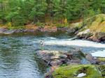
The water levels were obviously quite low, and I could have filled a tackle box with the various lures that were readily discernible among the rocks. As I stood out on a rock pitching my line out into the eddies, the scene of visionary enchantment that spread out before me made it virtually impossible not to achieve a sense of contentment.
Afterwards, we both spent a little time exploring the trails spider-webbing around the falls before heading back to camp to get supper started.

As Vickie was putting the finishing touches on supper, I made preparations for a fire afterwards by getting the wood situated under the fire grate. Of course this almost certainly jinxed us; as it started raining shortly thereafter.
While we were enjoying our chicken fajitas, a couple of kayakers were seen negotiating the portage just across the bay. They wound up claiming a site just north of us. As we watched this scene unfold, both of us commented about how thankful we were to be in camp, enjoying our warm supper under the dry sanctuary of our CCS tarp. And, more importantly, not out in the rain & cold still searching.
The rain continued after supper, so we played a few games of cribbage & listened to the weather radio for the latest forecast. Predicted winds out of the north at 10-15 mph with gusts up to 25 didn’t sound too encouraging. Especially since tomorrow we hoped to cross Basswood Lake.
Crooked Lake, Basswood River
Since I built it last night, we had a ready to light fire waiting for us when we got up. Once again it was a cold, gloomy morning. But, at least the rain was staying away. In short order we’d eaten breakfast, packed up, donned our rain gear and shoved off.
Our first portage was within eyeshot of our camp. Petit Rocher du Lac Croche, as the Voyageurs called it, climbs up to the top of the falls, and then beyond, over a good trail that isn’t overly long. This was a good warm up for the day, as we lingered in the area for awhile absorbing as much of this magical atmosphere as time would allow.

Before we could even get a good paddling rhythm established we were at our second portage – Wheelbarrow Falls.

There are chutes on either side of an island that divides the river. The channel on the American side is basically a long set of rapids, while the Canadian side is more precipitous. Both are picturesque.
Our portage landing was located on the island, and the trail ran along the left (north) side of the river. Portage de la Pointe Bois is a relatively flat, though exceedingly rocky path. In high water, the landing for this portage is difficult, if not impossible, to reach. In such cases, there is an alternate portage trail on the Canadian side. Although, when I’ve needed to use that one, the path has usually been a mud slick.
We were able to exercise our paddling muscles a little longer after that portage was completed. Next we paddled past the 60 rod portage up to the rapids before we realized we’d gone beyond the landing. In my opinion this was the toughest trail along the river as it twisted then climbed quite steeply. Another quick short paddle & we were at Horse Portage.
While the Voyageurs actually broke this one into 2 separate portages, Portage des Grand Pins & Petit des Bois Blanc. We chose to do it as one long portage.
Although this trail was over a mile in length, it was along a mostly level, well worn path. Along the way, there were several spur trails leading to the river. We just had to remember to keep right. Even though it was a gray & gloomy day, the vibrancy of the fall colors really shone through all along this portage. The oak trees in particular really added a special ambiance. Ruffed grouse also provided an occasional diversion from the task at hand.
As we dropped our first load off at the Basswood Lake (Lac Bois Blanc) end, we couldn’t help but notice a couple of men apparently trying to line their fully loaded canoe down the Canadian side of the falls. They seemed to stop when they noticed us, so we explored Basswood Falls before we headed back for our second load.


Upon our return, there was no sign of the 2 guys on the Canadian side. I scanned the water below the falls, half expecting to see a floating yard sale of gear bobbing in the foamy pool. Neither of us seen anything, so we presumed they must have made it.
After a short snack break, we pushed off into the largest body of water in the BWCAW, historic Basswood Lake.
With winds predicted to be coming out of the north, it was this section of the lake that had us worried the most. Although we felt that there were enough sheltering islands, to afford us protection until we got to the narrows leading to Jackfish Bay. From there we’d hug the protective northern shoreline, working our way to Back Bay.
Things went well, only some mild waves to deal with as we turned SW and headed for the narrows. Upon reaching the narrows we felt we’d be home free. That would not prove to be the case.
Contrary to predictions, the wind was coming out of the SW. And, with a vengeance! We fought the intensifying wind & waves before pulling off in a little cove to take a break. Rollers continued crashing in from Jackfish Bay, as we reconnoitered.
In keeping with one of the main themes of this trip; as part of our pre-trip planning, Paul Schurke (of Wintergreen Dogsledding) informed us of a new, undocumented, pictograph that they recently discovered in Jackfish Bay. I must admit, that throughout the genesis of our route, it never achieved ‘absolutely must see’ status. Still we knew we’d be passing by and, if conditions were favorable, it wouldn’t throw us too far off track. Obviously current conditions were less than favorable, so we didn’t even consider searching for them.
From where we were now, we were just about to turn and paddle to the SE. Getting around this point was going to be a little tricky, but once past, we felt we’d be OK until Back Bay. Initially we’d hoped to make it a little further, but now we had readjusted our sites to the campsite just north after the portage into Back Bay.
It was a little dicey getting around the point, but we made it in fine fashion. As we continued on, I tried to keep close to shore, but not so close as to catch a lurking boulder just below the surface. We’d really had to dig in a few times, and had to be ready to do so again at moment’s notice. So, when we turned into the small bay with the first campsite & were afforded a temporary free ride, I yelled to Vickie, “Take a break & rest up until we need to paddle again!” Ironically, as I rudder us along through the swells, this is even more unnerving than battling the waves was!
Mercifully, as we enter Lewis Narrows, the wind & waves relent. So, we are finally allowed to relax tense, overworked muscles and the pinkish hue gradually returns to our knuckles. This seemed to be a very pleasant section scenery wise. Of course, that statement should be tempered by the fact that, since entering the motorized zone, this was our first opportunity to contemplate something other than the next wave rolling at us. As we neared the portage into Back Bay; we once again enter the far north end of a SW orientated bay. So, predictably, the wind & waves were beginning to push us around yet again just as we pull into our portage landing. This portage was listed at 70 rods. In my travels around canoe country, I don’t recall crossing a trail in as good of shape as this one. Literally, you could drive a car from start to finish.
 This side of Back Bay was noticeably calmer. Although across the lake, rolling in through the narrows, whitecaps could be seen. Good fortune was on our side, as our targeted camp was unoccupied.
As we pulled up, the brisk wind was now being accompanied by a light snow. Even though the landing wasn’t the best, after battling waves for the last couple of hours, it was still a welcome change to finally be on terra firma for the evening. Our cursory examination enlightened us to the fact that this was not a great campsite, but at least it had one fairly decent tent pad. There was also a nice pile of welcome wood, and the seasonal colors in and around camp brightened an otherwise gloomy day. Since at the moment we weren’t particularly choosy, or willing to shop around, it would have to serve as our humble Hilton in the woods - or, at least, our budget hotel.


For the second evening in a row, the rain chased me back under the tarp just before lighting a fire. The only difference being this time there was snow sporadically falling too. Keeping us company - there was a solitary loon that hung out in front of camp while we ate our supper. Vickie kept us supplied with hot drinks as we hunkered down under the tarp and played a few games of cribbage while listening to the weather radio. The forecast predicted for tomorrow would basically be a repeat of today. We had originally planned on staying in a couple more days. With this forecast, we now agreed on the decision to paddle out tomorrow if conditions permitted. Hoping to get an early start in the morning precipitated an untimely retreat to the tent. The frigid & persistent rain aided in that regard as well.

Daily travels – 5 portages totaling 555 rods.
Basswood River, Basswood
We wake early to snowflakes floating in the crisp autumn air. I get a fire started, while Vickie prepares hot chocolate & oatmeal for breakfast. At this point in the trip, we’d become fairly adept at getting camp packed away quickly & efficiently. Once on the water, we paddled almost directly east then rounded the large peninsula into the lower lobe of Back Bay. At first flash, looking at the map, it appears that this is a large body of water. And, indeed it is just that. What the map doesn’t show is that a short distance south of the peninsula, the vast majority of the bay is choked with wild rice; leaving only a river like channel for unimpeded paddling.
As one might expect, we scared up countless waterfowl paddling down the bay. Certainly there were countless more concealed in the reeds. A trio of bald eagles was seen as we approached the islands in the south end. Without a doubt, we had seen more birds of every variety on this trip than we had on any trip prior. And Back Bay was absolutely a haven, which topped the list.
The upper lobe of Hoist Bay is much the same. The reeds & weeds finally give way once we enter the main body. Hoist Bay was once a hub of activity. It was here to this bay that the logging companies would float their logs so they could ‘hoist’ them onto the rail cars so the 40-ton Brooks locomotive could haul them to the saw mills in Winton. Thus explaining how Hoist Bay earned its name.
Accounts of travelers who started their trips here in those days, mention having to cross over large booms of logs before they could find navigable water. There is still clear evidence of this activity in the vicinity. In fact, had we decided to stay in another day, we wanted to explore the historic 4-mile portage. As it was, we just paddled around the pilings at the terminus of the old line. Rain started to fall, hastening our departure.

The outlet of Good Creek was also located at this very spot, so we were able to quickly duck out of the escalating wind & waves without much further ado.
Good Creek & Lake were named for G.H. Good. Superintendent of logging operations for Swallow & Hopkins Company until the mill shutdown in 1922. This company was responsible for logging more of the virgin red & white pine in (what is now) the present day BWCAW than any other firm. (600 million board feet - according to Miron Heinsemans’ book, “The Boundary Waters Wilderness Ecosystem”)
Good Creek was comparable to the other small streams we’d paddled already this trip. Fortunately we only encountered one beaver dam, and though extraordinarily weedy, we had floatable, paddle able water the entire distance until Good Lake.

Just before Good Lake there is a small rock/beaver dam that we had to portage around. Once we pulled the packs out of the canoe, we were able to just carry the canoe over this short rocky section, and then reload on the other side. We pulled off at the narrows to take a short rest/snack break. The light rain that had started up in Hoist Bay now changed to snow & sleet. The wind was starting to kick up some waves, but at least it would be at our backs until we got to the Hula portage.
This portage climbed out of Good Lake along a pretty decent path, emerging out on Hula Lake at somewhat of a sandy landing. Even though Hula Lake was full of wild rice, it provided some nice ‘change of pace scenery’ for a paddle through lake.

Much to Vickie’s’ angst the landing for our next portage was a huge mud hole. Fortunately there was a tiny creek running in just off the landing, exposing a few boulders which provided solid footing. This landing proved to be the only concern along this short portage.
While paddling the northern arm, we hugged the western shoreline of Wood Lake. Once we rounded the point and started heading west we realized we would have one last battle with the rain, wind & waves to overcome if we wanted to paddle out today.
Fighting our way westward, we paddled past the occupied narrows campsite where a couple guys were fishing from shore. By the time we turned south and began tracing the eastern shoreline the rain had stopped, but the wind had intensified. Growing weary, Vickie needed to pull off to catch her breath. Fortunately, a nearby miniature little bay afforded us an ideal opportunity to pull over and duck out of the waves. As an added bonus, once out on the shoreline, Vickie found some really cool fragmented rocks. Continuing on; the waves started receding once we passed the last campsite. Nearing the large island at the entrance to the southern bay, we saw something large moving in the marshlands to the SW. Of course we felt we were about to be treated to moose sighting; an epic fitting finale to our adventure. As we hurriedly pushed on with renewed vigor, a shotgun blast instantaneously dashed our hopes. What we had seen were actually a couple of duck hunters! Finishing up the last leg of our paddle in the small creek, we paddled past an old dilapidate wooden boat just before pulling up to the landing. As somewhat of a shocking contrast, there were also a few completely intact aluminum boats on shore near the landing.

Our last portage was upon us. Always an experience fraught with mixed emotions. Of course there’s the melancholy of the adventure coming to an end. Yet, there is the eager anticipation of that big juicy burger waiting for us in town & of course a hot shower.
The portage slightly climbs out from the landing. Naturally this is a well worn, wide open path. Although, when heading out as we were, it has a big finish. Just past the wooden walkway there is a substantial hill to negotiate up to the parking lot. Having gotten my loads across, I was able to return back down the trail in time to relieve Vickie of her burden for the last leg of the portage. (Including the hill)
With the van loaded up we headed for Ely, where we stopped back at Spirit of the Wilderness to check out their end of the season clearance & let them know how our trip had gone. Next, to The Boathouse for burgers, and finally off to my parents for an overnight visit and, of course, the eagerly anticipated hot shower.
Going in, we knew this was a route that could (and would) present us with various challenges. In particular, getting to Gull Lake on our first day was at our limit of aggressiveness for a first day. Later on, there were also a couple other long portages & an assortment of muddy creeks and landings that we dealt with as well. Crossing a windy Basswood Lake was a hair rising ordeal; but, in the end, also qualified as another satisfying accomplishment. While there were some bumps in the road, in the final analysis, I believe we spread the trip out over enough days as to afford us an adequate amount of R&R to equalize things.
As we traveled through this route, there were countless reminders of days gone by. It amazes me when considering how far the BWCAW has come. Often I hear (or read) about folks fondly recalling ‘the good old days’ in canoe country when it was a REAL wilderness. For my money, I believe that today this area is more wild than it has been in the past century plus.
Consider our route. - There was large scale logging into the 1920’s. Smaller scale logging into the 1970’s. - While the rail lines were pulled up in the 1940’s, countless winter roads were used until the 1970’s. - Planes were allowed on all lakes into the 1950’s, some (Fourtown for example) into the 1970’s. - There was an illegal road built through the area to counter the air ban. - There were many resorts, and even homes, on a number of lakes into the late 70’s – early 80’s. In fact, an entire Indian tribe lived on Basswood Lake until the 1940’s! - Of course, motors weren’t banned until the late 1970’s (and in some areas the early 80’s).
Really the big drawback (if you want to call it that?) is the fact that today more people are attracted to the area mainly because these things are no longer allowed. So, achieving solitude can be more of a chore than it was back then. Still, in my opinion, running across another group of campers or canoeists is nowhere near the deal breaker that encountering a boat, plane or a recently active logging camp (and everything associated with it) would be. Predictably; we did see several other groups throughout our route, and, as stated earlier, we came across campsites that had been clearly abused. So there is, and always will be, drawbacks. But, even when considering these things in conjunction with the fact that it rained every day except our first; I can unequivocally affirm the fact that we had a tremendously good time. Simply stated; while things may not be perfect, I am grateful for the great many sacrifices that have been made over the years so we (and others) could enjoy this truly exceptional area.

Daily travels – 4 portages totaling 384 rods. Entire trip – 27 portages totaling 2511 rods.
Basswood, Good Creek, Good, Hula, Wood