BWCA Entry Point, Route, and Trip Report Blog
July 13 2025
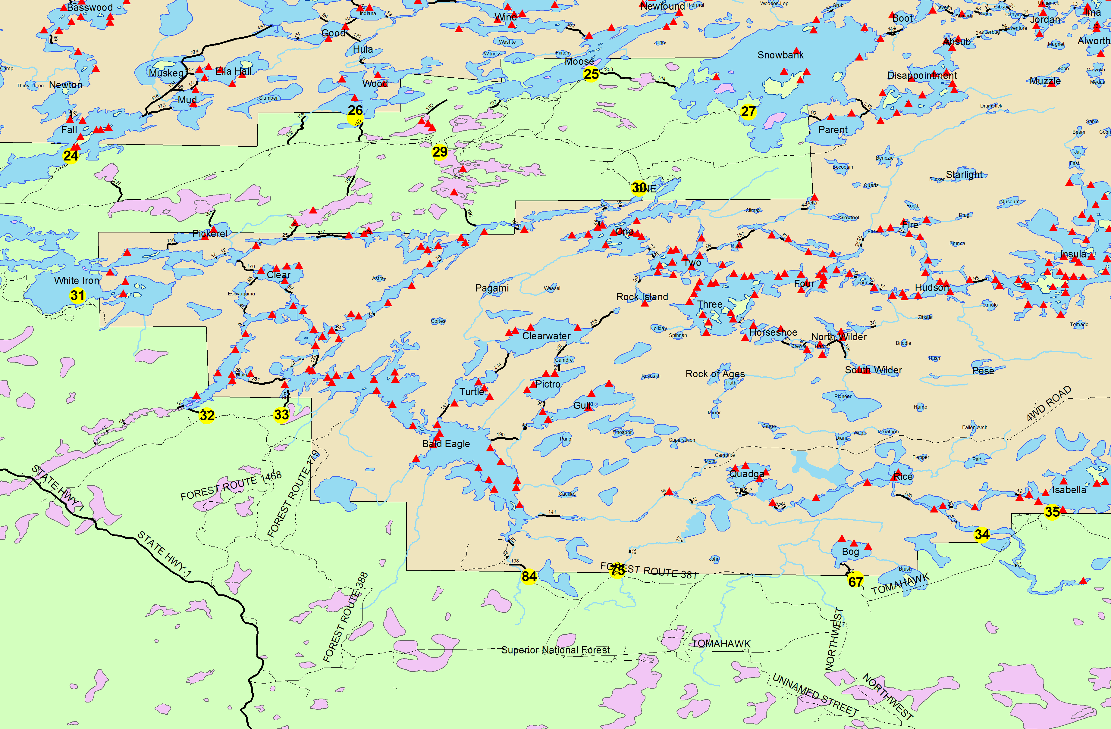
Entry Point 32 - South Kawishiwi River
Number of Permits per Day: 2
Elevation: 1201 feet
Latitude: 47.8419
Longitude: -91.6632
South Kawishiwi River - 32
Pine Lake base camping, Aug. 2016
Entry Date:
August 02, 2016
Entry Point:
Trout Lake
Number of Days:
7
Group Size:
7
The group decided to base camp this year, something I have never done. We got the permits late in the season, so we had limited EP options. Since EP 1 Trout Lake allows 14 permit per day, there were several permits available, even in the week leading to the trip. What sealed the deal was that I heard Pine Lake has good walleye fishing. Also, we liked the idea of Chad or Buck being options for day trips, or sites to move to if we get bored of base-camping.
It was recommended to me by several people to get a tow/ferry over Vermillion from Moccasin Point, which we did with Lonnie. It was $225 for 4 boats. (http://www.lakevermilionguidesleague.com/lonnie-johnson). It was easy to work with him and he’s a nice guy.
Day 1[paragraph break] Lonnie wants us there at 10am, which makes for an easy morning. I was glad we did the ferry. It’s not impossible to paddle it, of course. I’m sure it’s grueling in bad wind, but to me it was more about getting into the wilderness as fast as possible (at about $30 per person).
Lonnie pulled up while we were unloading our gear from the cars at MP. He said “On time is late for me.” We put your canoes and gear on his 30’ pontoon boat. Just kinda stacked them sideways on the the railings and tied them loosely. There are two portages from Vermilion to Trout, one about 120r and one about 40r. The 120 is the “mechanical portage” that Lonnie runs along with his ferry service. It costs more to have him haul your gear over the portage with a 4 wheeler. We opted out of the mechanical portage, and took the shorter 40r ourselves. Right at the entrance of it is a small creek and waterfall. There isn’t a great spot to moor there, so we just loaded the gear and ourselves into the canoes from the side of the pontoon. At the bottom of the waterfall you can see a massive submerged log shoot from around the early 1900s (I can’t find any info on this). The water is clear and you can see the structure very well. We also saw deer eating lily pads, and a bald eagle. 
Over the portage is a marshy area that opens up to Trout Lake. I was trolling a spinner bait through the weeds and caught my personal record smallie. Throughout the rest of the trip there were 3+ smallies this size and bigger caught. 
The wind was low, so we decided to paddle north to the 40 rod that connects to Pine Creek, instead of the 260 rod that goes directly into Pine. It made for a couple more hours of paddling, but we were all happy with our choice when we arrived. The Trout side of that portage is a ~75 ft long, knee to chest deep, sand bar beach, and a small creek of bright red, tannic bog water from Pine Creek that flows into the crystal clear water of Trout. It’s very cool too see the distinct separation of red and clear water. 

Over the muddy 40 rod, we started the ~2 mile paddle down Pine Creek. I love paddling narrow waters. 
By the time we entered Pine Lake, we were ready to find a site and be done for the day. I heard from a friend that the camp site on the western side of the biggest island was good, so we made our way there and also checked other sites along the way. Indeed, it’s a nice open site that is big enough to fit several tents. So we stayed there for 5 out of our 6 nights. 
The Middle Days (or, It All Blurs Together)
Pine is a small lake with several islands and bays, so there is a lot to explore without exhausting yourself paddling from one point to another. Another logging artifact we saw was the old dock on Pine, which I have heard mentioned on other trip reports. All that is left are the round log support poles, sticking up out of the water about 2-4 inches. I could not find a map with depth lines for Pine, but my guess is that the areas we fished were not deeper than 25’. So overall a shallow lake, which I think is another reason fishing is good, or easier. It's surely a beautiful area (what's not in the BW?), but Pine doesn't have the iconic, massive sheer rock cliffs that you will see on Lac La Croix, for example.
We also had a blown down tree in the water in front of our campsite that was used as a "dock". 
I was glad to give base-camping a whirl. Mostly because it means more fishing! My brother and I spent a lot of time lindy rigging deeper water, as we were told that other lakes in the area were producing around the 15-20’ range, being the first week of August. But our friend from Belgium, Jan, was catching more walleye just using jigs, swimmer baits, and Raps. For the first couple days, we were only hitting sporadically – a walleye here, a smallie there, then a few sunnies. A couple from our group found chanterelle mushrooms every day that we cooked along with the fish. We were lucky enough to have some true “northern surf and turf” a couple nights. 

One day, I learned a very important lesson about fishing. After fishing for several hours we went back to camp to rest a bit. Before heading out again, I put the fish in the water and tied the stringer to a rock, so that we didn’t have to paddle around with them. Well, I imagine many folks can guess what happened next. When we got back to the site, the fish were gone. I couldn’t figure it out. We were all pretty bummed. I was beating myself up for maybe not securing the stringer well enough. We were stipulating about bears, eagles, or maybe the big bass was just that strong …… hahahaha! But suddenly we spot a little head poke out of the water right where the stringer was. Snapper. Huge. This was a revelation for me, because I never understood why I’d see “live wells” made out of rocks in the shallows by camp sites. Now I know.
Another day, 4 of our campers decide they want to take a day trip to Chad. That’s a good 10 miles of paddling, with a ~260 portage there and back. I was enjoying my lazy time, so the 3 of us who stayed behind went fishing again. We were glad we stayed back, because we finally hit a walleye hole! Not only that, but there was a sunnie school right there with them. It must have been because of the dark brown water, that we were catching these fish in about 4’ of water! Way shallower than what my fishing buddies told me heading out. We came back with a full stringer of huge sunnies and nice eater walleyes, enough to feed all 7 campers. And this time we made a live well for the stringer! 
The 4 campers who went to Chad said it could have been a good lake to camp on as well, but that the portage was muddy and a little overgrown. They had had a long day, and were thankful for a big fish fry with Shore Lunch and more wild mushrooms.
At night, one of our campers said that she saw a mouse inside of the latrine. We all thought it must be trapped in there, but we looked and didn’t see it. Later on, someone else went to the latrine, and while sitting on the pot, heard rustling from behind in the woods. He turned around, and saw a mouse go down a hole, and emerge from the bottom of the latrine! When Jacob told us what the mouse was doing, we were all like, “WWWHHHY??”, and Jacob said, “For the nuts,” and we about lost it. No joke, on this island there is a shit mouse. It literally survives by eating undigested bits out of feces. Hooray Nature! [no pic]
It might have been that same night, while we were digesting a late dinner in the dark, that my brother saw a UFO. He pointed at the sky and yelled, “Look!,” and when I did, I saw two objects moving in the sky towards each other, then suddenly conjoin and get bright like a flare in the sky, and then as quickly disappear. I admit, I have never seen a satellite change in brightness that drastically ever. And half of us were convinced what we had seen was not a shooting star or a satellite.
The next morning, all of the whiskey was gone. Since we base-camped for 5 nights, we decided to head to Trout for our last night, and make for an easy return trip. The camp sites we looked at were obviously set up for 25hp motor boat camping. Folks that get their motor boats and gear towed over the mechanical portage bring “glamping” gear with them, like large canopy tents and heavy duty grills, etc. We finally found one site that was a smaller, more private, and hidden, on Windy Point. We had to cram to find tent spots but it was fine for only one night. The site has a nice shallow beach for swimming, and great views of the lake and sunset. 

We caught a few little smallies, and tried for walleye with no luck. Trout is large and deep, with lots of rock structure on the bottom, so it’s very difficult to fish there from a canoe.
We made our way back to the EP casually, but still ended up ahead of schedule, so I turned on my cell phone, and Lonnie was able to meet us earlier than we had agreed upon.
Here are a few more photos I thought turned out well: 


 [paragraph break]