BWCA Entry Point, Route, and Trip Report Blog
July 05 2025
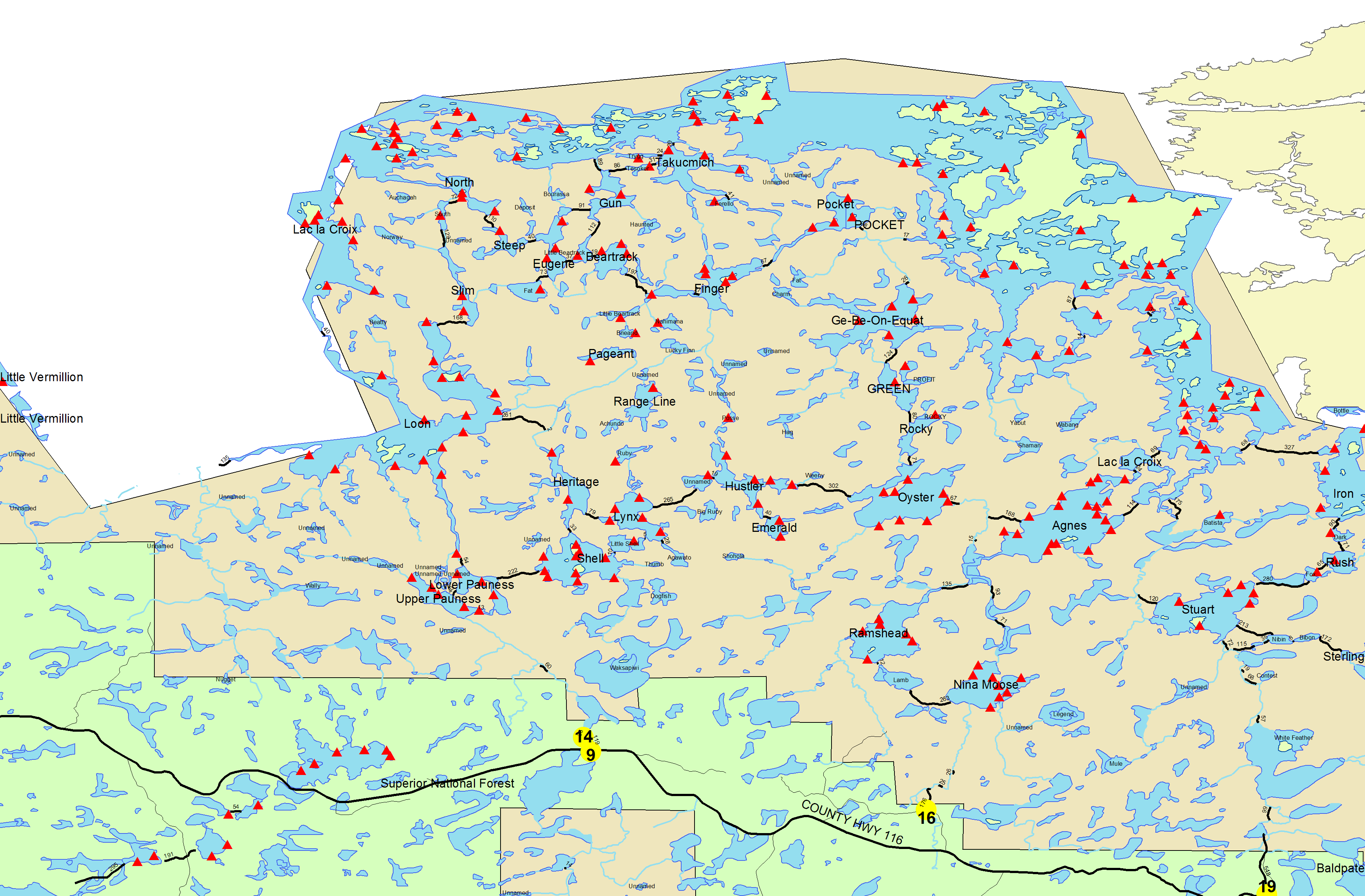
Entry Point 14 - Little Indian Sioux River North
Little Indian Sioux River (north) entry point allows overnight paddle only. This entry point is supported by La Croix Ranger Station near the city of Ely, MN. The distance from ranger station to entry point is 32 miles. Access is a 40-rod portage heading North from the Echo Trail.
Number of Permits per Day: 6
Elevation: 1364 feet
Latitude: 48.1466
Longitude: -92.2103
Number of Permits per Day: 6
Elevation: 1364 feet
Latitude: 48.1466
Longitude: -92.2103
Loop Around the Horn, EP14 to EP 16
by canoerone
Trip Report
Entry Date:
June 14, 2005
Entry Point:
Little Indian Sioux River (north)
Exit Point:
Moose/Portage River (north) (16)
Number of Days:
7
Group Size:
5
Trip Introduction:
Report
EP#14 TO EP#16 BIG LOOP
Early June 2005
Our BWCA trip for 2005 was envisioned as an effort to expand our reach and to seek out an area that would provide us with some quality solitude. After much consideration the route was settled on and the detail planning and preparations began. Our route would begin at EP #14, Little Indian Sioux River North head north through Upper and Lower Pauness Lakes, Loon Lake, Slim Lake, Section 3 Pond, South Lake, Steep Lake, Eugene Lake, Little Beartrack Lake, Beartrack Lake, Thumb Lake, Finger Lake, Pocket Lake, Gebeonequet Lake, Green Lake, Rocky Lake, Oyster Lake, Lake Agnes, Nina Moose Lake and then exiting on the Moose River at EP#16.
Our Entry permit was obtained through the lottery and our outfitting was placed in the very capable hands of Jim and Brett Hanson at Duane’s Canoe Outfitting in Babbitt. We headed north from Texas on June 12th, spent that night in Ames, IA and drove into Babbitt about 3:00 pm on the 13th. We stopped at a local bait shop to pick up our necessary fishing licenses and then headed to Duane’s.
We utilized Duane’s bunkhouse to save a little money and to ease getting our gear packed and ready for an early start to the drop-off point the next morning. We enjoyed a good meal at a local restaurant and then went to bed early with all of those pleasant thoughts of the coming week’s adventure.
DAY ONE – Travel day
We awakened to blowing wind, rain and the rumbling of thunder. Not to be disheartened, we had breakfast at the outfitters, loaded the van and headed north toward Ely and the Echo Trail beyond – hoping all the while that during the hour and a half drive to EP#14 that we would drive out of the rainy weather. Well, it didn’t stop raining, but it did stop lightning.
We started on our first carry at about 7:00 am. The 40 rod carry leaving the drop-off area is downhill all the way to the river and was a very easy way to start the day. The trail was wet from the rain but posed no problem for our group. We were too excited about getting on the water to be bothered by a little rain.
Our canoes were soon loaded and we headed north on the river. After about two miles of paddling, we came to the first river portage. This is an easy 60 rod carry that follows the river and offers a good view of a small waterfall. This was an easy portage, but one that ends at a very muddy put-in area.
We preceded up the river another mile and a half to Upper Pauness Lake where we picked up a pretty brisk northerly breeze in our faces. The north wind prompted us to take the shorter paddling angle across the lake and use the 40 rod portage at mid lake. This was not a good trade-off. It saved us quite a bit of paddling into the north wind, but the portage was a mess. It was ankle deep mud all the way to Lower Pauness.
It was still raining with a north wind in our faces as we made our way across Lower Pauness to the 160 rod Devil’s Cascade Portage. This trail starts climbing immediately and continues to climb to about midway where it levels off for 10 or 12 rods. It then starts down the steeper north side of the portage and descends all the way to the river. The rain was coming down harder now and made the steeper sections very slippery. The level section across the top was extremely muddy. So much so that the off-trail to the campsite and the gorge over-look was nearly impassible.
We had planned to eat lunch at the cascade campsite, but the rain and mud caused us to rethink that option and we moved on. Another two mile paddle in the wind and rain carried us to Loon Lake. Loon is a very large lake. The east bay alone has eight campsites and the Little Loon Lake extension offers two more. We stopped at the second campsite on the southeast shore of the east bay.
We were wet to the bone so we erected a rain fly over the cook area and got a fire going to warm our cold wet bodies. We had to setup our tents in the rain and falling temperature. The first night steaks and veggies helped to warm us up and gave us a little bit of encouragement. After dinner clean-up we all retired to our tents to get out of wet clothes and into our (thankfully) dry, warm sleeping bags.
DAY TWO – Travel Day
We awoke early to singing birds and sunshine. Thank you Great Canoe God! After a quick start breakfast, we broke camp and headed north on Loon Lake. We paddled across the East Bay of Loon, through the narrows connecting Little Loon Lake and on up to the portage to Slim Lake – about two and a half miles of paddling into a north breeze.
We were greeted by a small muddy take-out area and a nasty trail. The rain had turned the 173 rod trail into a fast moving creek. Where it wasn’t fast moving water coming down the trail at us, we were wading through ankle deep mud. It was a long tough climb followed by a pretty level section across the top and then downhill to the lake. The trail seemed to be little used and was overgrown and narrow in places.
Slim Lake is a long narrow lake with two campsites near the southern end. It is about a two mile paddle to the 52 rod portage to Section 3 Pond. We located the portage on the left side of the creek instead of the right side indicated on our map. The small take-out area led to a relatively level trail that followed the creek. As we had now become accustomed to, it was very muddy. The put-in area was very narrow with two trees that had to be negotiated to get away from the landing.
Section 3 Pond is very small, maybe a half mile long. It has one established campsite midway down the lake on the west bank. We were soon across the pond to the take-out for the 72 rod portage to South Lake. The trail climbs gradually up and over a rise and then down to the lake.
South Lake is the lower half of the combined North/South Lakes. The southern part has three campsites. The paddle across South Lake was a bit easier now that we had the north breeze behind us. It was a half mile paddle to the 120 rod portage to Steep Lake. Both ends of this portage were shallow and very muddy. The trail immediately starts climbing steeply for 60 or 70 rods and was very wet and muddy in spots. The trail levels off for ten or twelve rods and then drops sharply down to the lake. This was a rather tough portage made even tougher by the wet conditions.
Steep Lake is a rather small lake with two campsites. We paddled the ¾ mile across steep to a narrow take-out area for the 45 rod portage to Eugene Lake. This trail seemed to be little used, but was in pretty good shape. We only had lots of roots and rocks to contend with on the mostly downhill path. The put-in on Eugene was pretty good for a welcomed change.
Eugene Lake is a moderate size lake and relatively deep with two campsites. We checked out the northern campsite which proved uninviting. The campsite at the narrows was more to our liking so we settled in there. We planned to stay at the site for two nights to get a little rest and to spend some time fishing. Camp was quickly setup, rested a bit, had dinner, played some cards and then hit the sack. It had been a good day.
DAY THREE – Layover Day
We got up later than usual to a beautiful sunny day and proceeded to have a good hot breakfast of scrambled eggs and bacon. We had a pretty brisk wind most of the day that made fishing from the canoes a bit of a challenge. We did manage to boat a number of nice size pike before the breeze encouraged us to head back to camp.
As a side bar, I have to mention that as usual this time of year the mosquitoes and ticks were a bit of a nuisance. We continually checked for ticks to avoid letting the little boogers feed on us. It was at the camp on Eugene that one of the guys announced that he had found a tick embedded on his body in a very sensitive place. Being a bit shy, he refused to let anyone help him with the tick extraction. He took a pair of tweezers and headed into the woods. Several minutes later we were startled by a blood curdling yell from the direction he had gone. He soon emerged, gently rubbing the area of the extraction and was not amused by the laughter and jokes he had to bear. The scenario did encourage the rest of us to be more diligent in our own tick inspections.
DAY FOUR – Travel Day
We broke camp a little after 7:00 am on a bright sunny morning with little or no breeze. The lake was as smooth as glass. It was only about a 3/8 mile paddle to the thirty rod portage to Little Beartrack Lake. The small take-out area led to a rather steep trail for the first twenty rods then it dropped slowly for five or six rods to a three foot step-down to the water. The put-in area was quite nice allowing us to parallel load the canoes.
Little Beartrack Lake is a pretty, little lake with only one established campsite. It was only a ¼ mile paddle to reach the thirty rod portage to Beartrack Lake. The take-out area was very small and rocky. The trail was pretty nice with a gentle up hill slope for about twenty rods and a level path the rest of the way to the lake. The put-in area rocks made for some awkward loading and castoffs.
Beartrack Lake is about three times the size of Little Beartrack and appears to be pretty deep. It has three established campsites all on the upper half of the lake. The one half mile paddle across the lake was accomplished quickly and we were soon at the take-out for the 200 rod carry to Thumb Lake. This was not a difficult portage except for its length. It has a gentle up hill stretch for the first 70 rods and then it flattens out for a pleasant stroll through a stand of large pines. There were a few muddy spots and rocky areas on the downhill side that had to be negotiated.
Thumb Lake is small, narrow and about 3/4 mile long. It has one campsite at the western end. The paddle across the lake was very pleasant. The take-out area for the nine rod portage to Finger Lake was rocky but manageable. The portage is basically a lift-over. We removed a few packs and four-man carried the canoes across. The put-in area was a real mess, very shallow and muddy with no way to avoid it.
Finger Lake is a moderately size, relatively deep lake with four campsites. Two of the campsites are located on a large island in the east bay. We paddled the mile and a half across the lake and were impressed with the beauty of the area. We encountered the first other people since we had put in at EP #14 on Finger. They were heading the opposite way toward Thumb.
We located the 90 rod portage to Finger Creek and proceeded to unload. This trail is mostly downhill following close to the creek. It is a pretty good trail and offers views of several small waterfalls. The put-in was again very shallow and muddy.
We paddled down Finger Creek for about ¾ mile to Pocket Lake. Pocket Lake is a moderate size lake, but is relatively shallow. It has four established campsites. We check all four campsites and the only one that was inviting was the one on the west bank at mid-lake. We planned to lay-over a day on Pocket and the site selected proved to be more than adequate.
We ate lunch and proceeded to setup camp. After dinner fishing on Pocket was excellent. We caught many nice smallies and a few average pike. We had several smallies in the 20” range. One jumped eight times before being netted. We celebrated that evening with a nice campfire and roasted marshmallows.
DAY FIVE – Layover Day
Part of the group slept in this morning, but came running when the blueberry pancakes and bacon hit the plates. After breakfast we went back out to enjoy some more of the good smallie fishing. We continued to catch nice bass plus one real nice pike. The rest of the day was spent lazing around camp resting, napping, bank fishing or whatever. Two of us paddled over to the lake drain to see if the water level was sufficient to let us paddle out the next morning and avoid the 20 rod portage to the creek. It looked good so that would be our plan.
DAY SIX – Travel Day
We awoke early this day, had a quick start breakfast and hit the water. A rather stiff southern breeze greeted us as we headed across the lake to the creek. We paddled through the drain as planned and headed down Pocket Creek. About ½ mile down Pocket Creek we turned south on Gebeonequet Creek and followed its meandering course for an hour or so. At that point we encountered a picturesque waterfall that drained Gebeonequet Lake. The 35 rod portage around the falls is straight up a steep slope all the way to the lake. It is a steep, but short carry. Again, the put-in area was very tight and muddy.
Gebeonequet Lake is a large, deep lake with five campsites and nice clear water. It is reported to be quite a good fishery, but we were just passing through on this day. The large expanse of Gebe didn’t make our paddle into the stiffening wind very easy. We battled 10” to 12” rollers all the way to the 135 rod portage to Green Lake. The trail to Green was a pretty good path, climbing quickly in the first third of the portage and then gradually descending to the lake and a nice put-in area.
Green Lake is a small, shallow lake about one mile long with one established campsite. The lake runs north and south so we were again fighting big rollers the length of the lake. The take out area for the 85 rod portage was narrow and rocky. The trail climbs steadily for the first half of the portage then levels off a little before dropping rapidly to the water.
Rocky Lake is a small, deep lake with one campsite at the north end. It is a very scenic lake with some pretty impressive cliffs, but paddling into the stiff breeze did not give us much opportunity to enjoy the view or take any pictures.
We found another rocky challenge at the take out area for the 65 rod portage to Oyster Lake. The portage trail was pretty steep for the first 20 rods then it leveled off and was a gentle downhill path the rest of the way. Reloading the canoes was difficult due to the rocks and the waves coming straight into the loading area.
Oyster is a large, deep lake with seven campsites, but the morning wind in our faces had taken its toll. We headed for the first campsite on the map. It was the site on the peninsula with lake access on both sides of the campsite. It turned out to be a very nice site. Being able to carry our canoes across the campsite would save us over one-half mile of paddling the next day.
We had lunch and leisurely setup camp. A siesta was then in order, we were all a bit weary from the hard paddle of the morning. We fished after dinner and boated a few nice smallies and then returned to camp to prepare for our departure the next morning. We had a pretty intense thunder shower during the night with a lot of thunder and lightning.
DAY SEVEN – Travel Day (Have to leave darn it)
We broke camp early after a typical quick start breakfast, happy to note that the strong south breeze of yesterday was no longer hampering our travel. It was a beautiful BWCA morning. We paddled across Oyster to the 60 rod portage to the Oyster River. The take out area was nice and the path relatively flat for the first 20 rods and then rolling the rest of the way to a nice put-in area.
As we paddled south on the meandering Oyster River it was apparent that there was enough water flowing to allow us to bypass the 160 rod portage to Lake Agnes and stay with the Oyster River all the way to where it joined the Moose River. We had one short 20 rod carry around a small rapid, but it was accomplished quickly. We soon joined the Moose River and continued south toward EP #16.
After about one mile of paddling we encountered a 96 rod portage around another rapid. It was a nice flat and sometimes rolling trail that follows along the east side of the river. Another ½ mile on the river brought us to a picturesque waterfall draining Nina Moose Lake. The 70 rod portage around the falls is all up hill to the river beyond the drain. Nice trail except for the up hill carry.
Nina Moose Lake is a large, shallow lake with eight campsites. The paddle across the lake was uneventful but we did pick up a gentle southerly breeze. It wasn’t enough to slow us down, but it did feel good on a warm day. Nina Moose looked like it would be a good pike lake. We paddled to the Moose River exit and again followed its meandering course through a swampy area.
There are two short portages to be negotiated on the last stretch of river leading to the entry point. One is about 25 rods and the other is 28 rods. Both circumvent small rapids with nice trails and good take out and put-in areas. You barely get up a good head of steam after the second short portage and you are pulling into EP #16 exit trail.
The take out area was good and the trail was in excellent condition. The only downer was that the carry was a steady climb all the way from the river to the drop-off area. The map says the carry is 160 rods, but the Forestry sign at the parking area says it is 176 rods. Either way, it is a tough carry after a long day of paddling.
All in all, we had a great week, even with the first day drenching. Our route took us deep into the BWCA wilderness where we had the lakes traveled all to ourselves. We had excellent fishing, good campsites and gathered many new and lasting memories.
As a wise man once said, “it don’t get no better than this”. We have already started planning for our next trip.