BWCA Entry Point, Route, and Trip Report Blog
July 13 2025
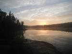
Entry Point 16 - Moose/Portage River (North of Echo Trail)

Number of Permits per Day: 5
Elevation: 1348 feet
Latitude: 48.1230
Longitude: -92.0991
A favorite route offering many trip options and memorable things to see including;
World Class fishing for all four BWCA Species
Pictographs
Soaring granite hills and cliffs
Small lakes
Small rivers
Tumbling rapids and waterfalls
Wildlife, including Moose
Vistas from high points across the region if you're willing to climb. Rating Easy to Moderate. Day One. Get to EP16 off of the Echo Trail early. The initial portage is long, but well worn and smooth, sloping gently downgrade to the launch area. Load your canoe and head North. You'll be paddling with the slight current on this narrow winding river. The water is clear and make sure to tell the bowperson to watch for looming rocks!
A trip of many firsts.
Entry Date:
May 28, 2011
Entry Point:
Mudro Lake
Exit Point:
Moose/Portage River (north) (16)
Number of Days:
5
Group Size:
1
Day 1 Summary: Mudro-Sandpit-Tin Can Mike-Horse River-Horse Lake I put in around 9:00 a.m. and was at camp around 5:00. There were a few points along the Horse River where I had to portage around some rock gardens that were exposed, due to low water. If I were in my own canoe I would have paddled through the rocks, but I wanted to baby the Kevlar canoe. 


Day 2 Summary: Horse Lake-Crooked Lake
Broke camp around 6:00 and set up camp in Sunday Bay. How appropriate to camp in Sunday Bay on Sunday. There is no place I would have rather been then right where I was. 


Mark told me to avoid the 320 rod portage from Iron to Boulder Bay. He advised me to take to Bottle Portage instead. However, because the weather was so terrible, I had no choice but to take the longer portage. This trail was lightly traveled, by humans at least. I saw fresh wolf, moose, and bear tracks on this trail. The trail was a little sloppy, but relatively flat. I found the first open campsite in Boulder Bay, which was a five-star site. I set-up camp, ate, and caught some smallies and walleye from the bank. My only complaint so far was how dirty the campsite was. There were orange peels, sunflower seed shells, and other trash everywhere. After cleaning up camp, I explored around the area for a bit, and hit the hay.
Day 3 Summary: Crooked-Iron-LLC
Regardless of the wind, I was able to cover a lot of water. One disadvantage to getting an early start is that you can leave a nice campsite and then get stuck in some nasty weather with no where to go. I realize that I could have just setup camp in an undesignated area, but there were enough islands on Iron that provided protection, thus allowing me to avoid the open water on my way to Boulder Bay. 

Mark told me to avoid the 320 rod portage from Iron to Boulder Bay. He advised me to take to Bottle Portage instead. However, because the weather was so terrible, I had no choice but to take the longer portage. This trail was lightly traveled, by humans at least. I saw fresh wolf, moose, and bear tracks on this trail. The trail was a little sloppy, but relatively flat. I found the first open campsite in Boulder Bay, which was a five-star site. I set-up camp, ate, and caught some smallies and walleye from the bank. My only complaint so far was how dirty the campsite was. There were orange peels, sunflower seed shells, and other trash everywhere. After cleaning up camp, I explored around the area for a bit, and hit the hay.
Day 3 Summary: Crooked-Iron-LLC
Regardless of the wind, I was able to cover a lot of water. One disadvantage to getting an early start is that you can leave a nice campsite and then get stuck in some nasty weather with no where to go. I realize that I could have just setup camp in an undesignated area, but there were enough islands on Iron that provided protection, thus allowing me to avoid the open water on my way to Boulder Bay.
Day 5 Summary: Agnes to EP 16. Trip time 6 hours, but with a strong wind.
Trip Summary: This trip was a trip of many firsts. First trip to the BWCA. First solo trip. First time canoe tripping. First Northern Pike. First Smallmouth. I absolutely loved this place. Although I experienced many firsts on this trip, I know that it will not be the last.
After getting back to civilization, I checked the Weather Channel's history and the winds were in the 40 mph range, with gusts in the high 50s. Not exactly paddlecraft weather, but none the less a PERFECT FIRST TRIP.