BWCA Entry Point, Route, and Trip Report Blog
June 30 2025
Entry Point 14 - Little Indian Sioux River North
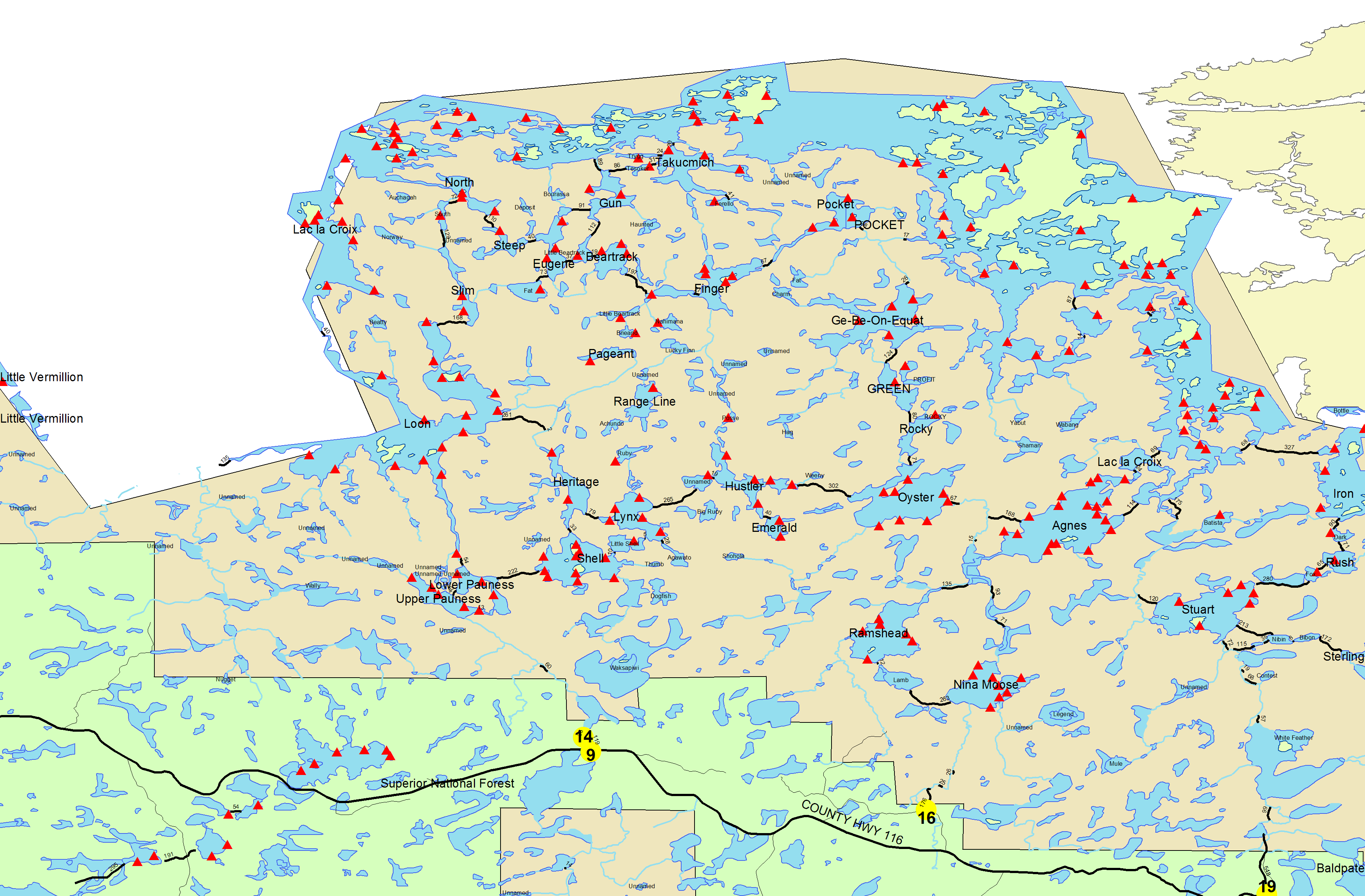
Little Indian Sioux River (north) entry point allows overnight paddle only. This entry point is supported by La Croix Ranger Station near the city of Ely, MN. The distance from ranger station to entry point is 32 miles. Access is a 40-rod portage heading North from the Echo Trail.
Number of Permits per Day: 6
Elevation: 1364 feet
Latitude: 48.1466
Longitude: -92.2103
Wednesday, June 08, 2022 Slept in my truck in Grand Marais the night before and got up nice and early for breakfast at South of the Border cafe, always so good. Went up the Gunflint to Seagull Outfitters and got a tow to American Point. We were able to make good time down to Ester and set up camp at the first site on the east side, by the portage to Ashdick. It's a nice campsite, we had room for our two hammocks, but there probably wouldn't have been room for more hammocks. There would be plenty of room for 2-3 tents. The mosquitoes on the portages and in camp were unreal. If you had any flesh exposed you got swarmed.
Cummings Lake Trip Report
by hmf4
Trip Report
Entry Date:
June 30, 2007
Entry Point:
Crab Lake and Cummings from Burntside Lake
Number of Days:
5
Group Size:
2
Trip Introduction:
This is our second trip to the BWCA. Last year we looked like a couple of Paris Hilton's with all the junk we brought. :) We learned our lesson though and this year was alot better.
We arrived Friday night, June 29th at about 8:00pm via my friend’s private plane. It’s the only way to travel! We grabbed some chow at the Ely Steakhouse and bunked at Voyageur North Outfitters.
Day 1 of 5
We headed out 7:30 am Saturday morning. The folks at VNO towed us across Burntside Lake to the Crab Lake portage. I broke my ankle in December and had 2 plates and 5 screws installed by the surgeon – needless to say I was a little apprehensive about the mile long portage to Crab. We got about 30 yards in the portage and realized we had not applied bug dope. Whoops! Once slathered up we were on our way. The Crab Lake portage is long but not too difficult. It took about 35 minutes each way and it took us two trips. By 9:30 we were paddling up Crab Lake. We continued on through the 20 rod portage to Little Crab, onto the Korb River, and then took the 70 rod portage into Cummings Lake. We were hoping to set up camp at the first island campsite but it was occupied so we landed at the northern island site and it became “Home Sweet Home”. The trip in was 5 hours total. We set up camp right away and set out for firewood. We found a dead cedar tree still standing across the way from our site and two hours later we had enough wood split up for the whole trip. We went for a quick fishing trip, cooked a little chow, had a fire and crashed at around 10:30. 
Day 4 of 5
Sunday, July 01, 2007 - Our plan was to get up at 5am on Sunday and get fishing right away, but we decided to sleep in after a long hard day traveling in. After a little breakfast we were on the water fishing. We started catching smallies on crankbaits – infrequently. Back to the campsite for late lunch and with slightly darkening skies we were back on the water. More smallmouth on crank baits and it rained on us for about an hour. That killed any desire for a fish fry so we cooked up one of our freeze dried dinners. Another fire with vodka and fruit drink finished off the night. 
Day 6 of 5
Monday, July 02, 2007 - Monday morning it started raining about 4:30 am and didn’t quit until close to 10:00am. It was also pretty dang chilly. We guessed it might be only 60 degrees or so. We scarfed down some chow and started fishing. We started catching smallmouths on leaches right away. Not very big, but plenty of ‘em. Ran into the first people we had spoken to the whole trip. Spent mid afternoon reading and napping and picking ticks off our legs – they were everywhere! Once again we finished off the evening with a fire and the vodka/fruit juice combo. 
Day 8 of 5
Tuesday, July 03, 2007 - Tuesday had been declared serious fishing day, so we were up and at it by 5:30am. We stayed with the jighead/leech combination and started catching smallies right away. Jim caught a really nice largemouth that went close to 3 lbs. I pulled a couple more large mouths out of a blown down tree and it was time for shore lunch. Honest Abe, our resident eagle watched carefully as I cleaned our fish and Jim did a great job cooking up our catch – it was delicious! We took a short break and then got back after it. Late in the day I started catching smallies on topwater. I must have caught a fish on 20 or 25 consecutive casts. It was a blast. All told, we think we caught about 150 smallies on the trip. None of them were very big, but the action was steady the whole trip. And of course, the evening was wrapped up with a fire and the last of the vodka and fruit juice 

Day 10 of 5
Wednesday, July 04, 2007 - It was time to pack up and head out Wednesday. The weather was fantastic. We decided to take Korb Lake home. It was a little marshy at the portage, but a pretty paddle. The trip out was uneventful and took the same amount of time as coming in. We got back to Voyageur North Outfitters for a shower and shave and a lift to the airport. Jim had us back in Milwaukee at 5pm – just in time for dinner! Great trip all the way around – we would definitely recommend Cummings Lake for some smallmouth action! Thanks to John and Lynn at VNO for setting us up again – Great Job!!


discuss this trip report (4 comments) - last post on June 10, 2015