BWCA Entry Point, Route, and Trip Report Blog
July 04 2025
Entry Point 54 - Seagull Lake
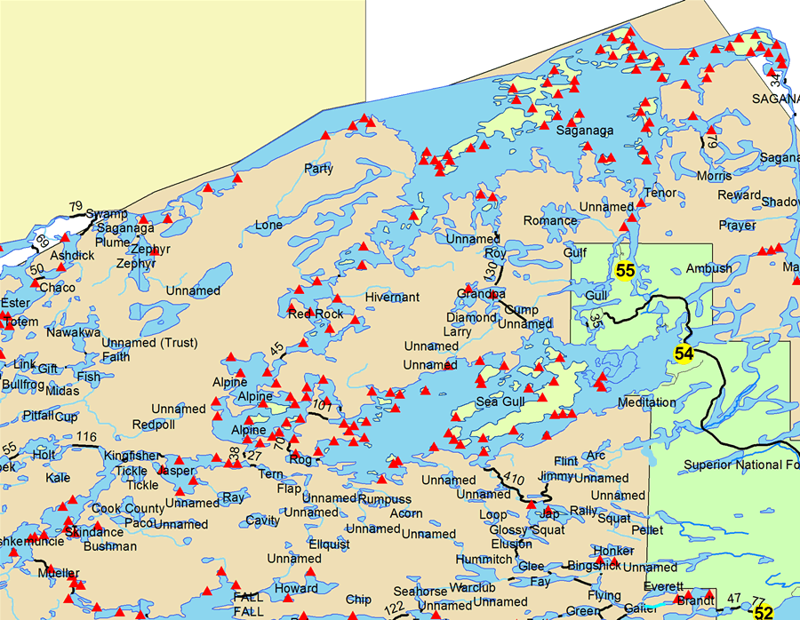
Seagull Lake entry point allows overnight paddle or motor (10 HP (except where paddle only) max). This entry point is supported by Gunflint Ranger Station near the city of Grand Marais, MN. The distance from ranger station to entry point is 50 miles. No motors (use or possession) west of Three Mile Island. Large lake with several campsites. landing at Seagull Lake. This area was affected by blowdown in 1999.
Number of Permits per Day: 8
Elevation: 1205 feet
Latitude: 48.1469
Longitude: -90.8693
Seagull Lake - 54
Number of Permits per Day: 8
Elevation: 1205 feet
Latitude: 48.1469
Longitude: -90.8693
Seagull Lake - 54
Solo Trek into Quetico - No Country for Old Men
by Beemer01
Trip Report
Entry Date:
June 16, 2010
Entry Point:
Moose Lake
Number of Days:
7
Group Size:
1
Trip Introduction:
Every step needs to be measured. Every step needs to be tested
A single misstep, a twisted ankle and broken limb and it would likely be days, perhaps longer before I was able to get help. A more serious compound fracture and I'm probably dead. I tested my traction on the wet slippery granite and like the rock climber I once was, advanced slowly up the massive dome of Canadian Shield leaving Isabella Lake with the canoe on my shoulders. Still, I reflected in the drizzling rain, this was easier than a day earlier with 55 MPH driving wind on the big waters of North Bay…..
Day 1 of 7
Wednesday, June 16, 2010 Day One. Prairie Portage to Burke Lake. Easy day, a morning tow up to Prairie Portage - a nice conversation with the lone lass completing forms and collecting fees and I paddled my wooden solo across Basswood on the calm waters of Bayley Bay. Over the years I've developed a system of GPS, Fischer Maps and a canoe mounted compass to compensate for my dismal navigation skills - the sandy beach showed up precisely where it was supposed to be. I paddled in turned parallel to the shore and got out - a quick double pass over the Yellow Brick Road Portage and I was at Burke Lake. I grabbed a Five Star campsite on Burke as I sensed that the forecasted afternoon thunder storms might be arriving a bit early. In setting up camp I opened my campstool and found it still covered with the dust of Alaska and Canada's roads from a trip a year earlier. I washed the dust of the Dempster and Dalton off in the clear waters of Burke Lake. The air grew hot, heavy and still as I fixed my first evening Steak and Hashbrowns over the fire. [IMG]http://i54.photobucket.com/albums/g96/Beemer10/P6170015.jpg[/IMG] The birds - earlier singing and flitting about - grew silent as the clouds darkened and the weather closed in. No chance I was going to miss this blow. I walked down to the lake and pulled my little solo canoe up on shore, flipped it and tied the bow painter off to a handy branch… testing the knot with a tug. The wind started to quicken as I dropped the sides of my tarp, and buttoned up the packs. I walked over to my Hennessey Hammock and double checked the tarp and anchor pegs. The first drops pelted me as I walked over to my waiting campstool under the tarp. I have never - in nearly 40 years of camping in the Canadian Boreal Forest - seen a rainstorm like this one. Based on nothing but a guess, I'll wager over 4" of rain fell in a six hour period. Wave after wave of rain drenched my little island and whipped my campsite, fortunately the wind wasn't bad - but that would change. And soon. Everything got damp as I read my book, smoked my cigar and sipped my Sour Mash. I eventually decided that the rain, rolling thunder and cracking lightning were going to continue all night so I retired to my hammock.
Day 3 of 7
Thursday, June 17, 2010 Day Two. Burke Lake to Isabella Lake. A Bluebird morning - the birds were back as I rose, drank my coffee, ate my Powerbar and packed up a soggy camp. I paddled glassy water as I headed North on Burke and made my way to Basswood's North Bay. Suddenly there was wind. A lot of wind. Really a lot of wind. I later found that winds that day were 30-40 MPH with 55 MPH gusts. White caps with blowing spray and tendrils of streaming Spindrift foam - waves with crests 10-14 feet apart as the waves cranked up over the 3-4 mile reach of North Bay. When you see Spindrift - you are seeing Gale Force winds. Great - well, a chance to defy the wilderness gods again and to see how good a paddler I really am. I loaded my little handmade canoe - checked the trim, cinched my PFD and headed out, careful to quarter across the waves blowing out of the Southwest. I hopped across the big water of North Bay, island by island with white caps breaking and occasionally cresting into my canoe. [URL=http://s54.photobucket.com/albums/g96/Beemer10/?action=view¤t=P6170021.mp4][IMG]http://i54.photobucket.com/albums/g96/Beemer10/th_P6170021.jpg[/IMG][/URL] I actually only came close to capsizing twice when I had the wind at my back and was surfing in on the final leg …when the canoe is balanced Stern to Bow on the rolling waves, stability is at a premium. I reached the Isabella River, paddled upstream and across the same Beaver dams my son and I had seen when we passed thru here in 2003. [URL=http://s54.photobucket.com/albums/g96/Beemer10/?action=view¤t=P6170026.mp4][IMG]http://i54.photobucket.com/albums/g96/Beemer10/th_P6170026.jpg[/IMG][/URL]The wind continued to howl and gust, but sheltered as I was on this little river it only seemed a bother when trying to portage and discovering that the canoe wanted to weathervane on my shoulders and twist off. Several portages in I was starting to get my rhythm when I heard a sharp crack…. and froze in my muddy tracks. A 50' Birch Tree - blown by the relentless howling winds - crashed to the ground in the forest not 20 yards from me. I continued on the portage with a weather eye (and ear) peeled. At the end of the muddy portage into Isabella I found that this Northeast - Southwest oriented narrow glacial lake was naturally another howling mess of whitecaps and windblown spray…. This time I was destined to head straight into the jaws of the storm. By the way - this amazingly windy day was sunny, bright and cool. I stayed close to the West shore and battled my way a mile or so up Isabella to a beautiful campsite perched high on a bluff at the narrows overlooking that long Gem of a lake. [IMG]http://i54.photobucket.com/albums/g96/Beemer10/P6180038.jpg[/IMG] I tried to rig my tarp and hammock with absolutely no success, the winds - even higher on that bluff - would have none of that! I eventually retreated to a more sheltered area down from the commonly used campsite on the crest of the bluff and was able to set up a gypsy camp successfully. No fires today under any circumstances! I tried my hand fishing the narrows from shore - attempting to battle the wind with heavier lures. I walked around the edge of the lake on the lichen covered rock looking for a better place to cast. And slipped, falling 3-4 feet into the (fortunately) deep water off shore - it happed in a nanosecond, but I wasn’t seriously injured and my fishing rod and reel were retrieved with no effort or damage. Wow - that happened fast - watch your step out there! I ate a quick freeze dried meal on water heated on my Jetboil (I love this thing!)
Day 7 of 7
Friday, June 18, 2010
Day 9 of 7
Saturday, June 19, 2010
Day 13 of 7
Sunday, June 20, 2010
Day 16 of 7
Monday, June 21, 2010
Day 19 of 7
Tuesday, June 22, 2010