BWCA Entry Point, Route, and Trip Report Blog
July 01 2025
Entry Point 27 - Snowbank Lake

Number of Permits per Day: 8
Elevation: 1191 feet
Latitude: 47.9716
Longitude: -91.4326
Snowbank Lake - 27
Snowbank to Fraser and Back (the what not to do edition)
Entry Date:
July 09, 2017
Entry Point:
Snowbank Lake
Number of Days:
5
Group Size:
2
Sunday, July 09, 2017
 We were up bright and early, and treated to a fantastic sunrise out the back window at my parent’s house. We stumbled downstairs to the breakfast table for pancakes and Zup’s breakfast sausage. Of course, it was delicious as always. We loaded up the food pack and hit the road by 6:00.

On our way out to Snowbank Lake, we came across a mini-van with a person who looked to be sleeping, sitting in the opposite lane. We called it in to the police (which took some transferring, because we had technically just crossed over into Lake County), just in case. Not sure what happened to him, but hopefully they were able to help him out and get the car out of the traffic lane without any further injuries! The rest of the drive went very smoothly, and we arrived at the parking lot by 6:40. The water on Snowbank was (thankfully!) calm. The sun was peaking out past the few clouds in the sky, and we were the only ones at the entry point loading in. 
We quickly got everything to the lake, and pushed off at 7:00. It was already at this point that I can say I made Rookie Trip Leader Mistake #1. We started paddling and headed for the east side of Harry’s Island, which should have put us on target to get to the northeast end of the lake. I was watching the map, and everything seemed to be going well, until we were at the point where we would be officially crossing into the BWCA. As I slowly looked around and announced, “Well, we are officially in the Boundary Waters!” II noticed that there was a cabin on the shore north of the line. That is strange, I thought. As we continued to paddle, it soon dawned on me what had transpired. Instead of heading northeast from the landing, we actually headed a little southeast, and the island that I thought was the Harry’s Island was actually Burnt Island! As I said, Rookie Trip Leader Mistake #1 – Forgetting to consult your compass and map before you paddle.[paragraph break]
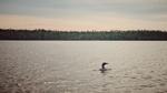
After our minor one-mile detour, we were now heading to the north side of Snowbank. Along the paddle a pair of loons decided to hang out with us for a bit. We snapped some photos, and wanted to stay with them, but pushed on. We were definitely in the BWCA now!
 We quickly found our paddling rhythm, and made steady time across Snowbank. Even with the detour it only took us 80 minutes. Our spirits were high as we pulled into the Boot Lake portage. The initial plan was to take the longer, single “north” portage that shows on some maps. Unfortunately it quickly became apparent that the “north” portage no longer exists, so you have to take the south portages. This adds one additional portage and a short hop across a pond. The two portages themselves were not exactly memorable, but it was definitely foreshadowing what was to come. At this point I also made Rookie Trip Leader Mistake #2 – failing to stay organized. Rather than having a systematic plan for unloading and reloading the canoe, we just pulled all of our bags out and set them down again, without really thinking about how, why or where. We just wanted to get them out of the way in case someone else came in behind us to the portage. That was a mistake we would repeat numerous times which cost us extra exertion and time spent. We really should have planned the loading and unloading to minimize the carrying and moving. If you pick it up, put it on and take it across!
It was also at this point where I realized the mistake we made with our packs in general (other than bringing too much stuff, which is always an issue). We cobbled together the existing packs we had for the trip, rather than borrowing my parents Duluth Packs because I thought we would want to use the more modern style bags with comfortable shoulder straps that we had accumulated over the years for this adventure or that adventure. The problem was that each pack didn’t hold a lot, so we were each double portaging, every time. In all, we had 3 non-canoe packs, a CCS Deluxe Food Pack, and a smaller hunting pack, which contained my camera gear and other quick access items. I carried that with the canoe and then returned for the CCS Deluxe Food Pack (I picked it up used from Piragis, and it’s awesome) on the second trip. My wife was then left carrying our three other packs in two trips with basically all of our gear. One was a Cabelas bag that is really a hunting bag, one was an old Kelty backpacking bag, and one was a simple backpack that could fit probably 2000 cu in of stuff in it. All three bags in total could likely have fit in a #4 Duluth pack. The portages on this route are not long, and most are not hard. It is just the cumulative effort of picking up, putting down, picking up, putting down etc. that takes its toll on you. Not to mention if we had fit all the rest of the gear in one pack instead of 3, we could have traded off on the double portage, instead of both of us double portaging every time. [paragraph break] Side note on camera gear. All of the photos were taken with either my Nikon D7100 or my iPhone 7+. To be honest, I reached for the iPhone a lot more than the D7100 because it was easily accessible and always with me. For the Nikon D7100, I was carrying several lenses, including an all metal, tank-built AF 300mm f/4, which is a great lens, but just too heavy. After we returned home, I sold all of my Nikon gear and moved on to a Fuji X-system camera. It weighs ¼ of my Nikon gear and is a great system. I now have a Fuji X-E2s, and 4 lenses ranging from 16mm to 200mm. Combined the entire system weighs about as much as my 300 f/4 did. [paragraph break] Back to the trip report! We then hit Boot and loaded up everything into the canoe and pushed off. 15 minutes later we came across another somewhat unexpected portage. There is a portage into Haven Lake that is not shown on the online maps (but it is on the Fisher maps). It is just a short pull-over, but again, it means stopping, unloading everything, moving it across the hump and then reloading everything. 5 Minutes of paddling brought us to the Haven to Abinodji beast of a portage. This portage is every bit as tough as you previously described by others. It starts with a significant climb on wet and slippery rocks, and ends with a significant descent on wet and slippery rocks. It is also rather narrow and does not look like it is used all that often, which makes complete sense now that we have completed that loop. Perhaps it was mental, but it definitely felt longer than 80 rods and had more elevation change that the elevation chart would suggest. It was at the end of this portage that I actually slipped and fell with the canoe on my shoulders. That is the first time in my life that I have had that happen. Luckily the canoe stayed in place and I wasn’t any worse for the wear. You hit the water on Abinodji, and not 10 minutes later you are at another portage. Well, you are at another portage if you can find it. 
he portage from Abinodji into Swing Lake is a little tough to find. On the maps it looks like it is on the eastern shore, but in reality it is at the north end of the bay area. ALL the way north. (Check your compass people!) Our spirits were starting to sag a bit after unloading again for this portage, and then the mosquitos decided to show up! The portage into Swing is a muddy-buggy-mess, and the actual launch into Swing is a bog with boards to stand on. Definitely not a portage that you want to hang around at or any kind of rest upon. Our dog copper was being a real trooper. He of course had to carry his own weight (and food) as well! Unfortunately at this point our nice new retractable leash broke, so that added to the fun! (Don’t bring a retractable leash.) We loaded back up, and then proceed to paddle 5 more minutes to cross Swing, quickly arriving at the portage into Gibson. The portage into Gibson isn’t very memorable either. Pretty flat and narrow. Once again we loaded everything up, and within 5 minutes we were unloading at the portage to Cattyman. At this point, I was pretty much fed up with the little ponds and portages. It was now already 1:00 and I realized that I had made Rookie Trip Leader Mistake #3 – forgetting to eat. We had not had anything to eat, at all. We were drinking water, but we didn’t eat anything, and our energy level (and mental faculties) suffered as a result. Thankfully, Cattyman Falls is a great place to take a break and have some lunch. We moved everything across the portage and out of the way in case anyone was coming, and sat down for a little break and some sandwiches. There is something about a sandwich that has been stuck in a backpack all morning, slowly being squished that is so satisfying on the side of a portage trail. 
I also started looking at the map and counting how many portages we had left in order to get to Fraser (7 more to go!), and the likelihood of us making it in one day was dwindling quickly. After a brief rest, we pushed off, and (of course) 10 minutes later, we were at the next portage, this one was to get to Jordan Lake. With this portage, we also were now on the same course as anyone who would have come through Disappointment Lake. Very quickly we realized that the number of people using this portage was exponentially higher, judging by the condition of the portage. The path was wider, more worn down and we actually saw people for the first time! The paddle across Jordan and up the narrows was the longest we had since snowbank, but it still only clocked in at 20 minutes. 
There is no mistaking where you are when you paddle through the Jordan Narrows. It is typical BWCA all the way! A quick note about the picture above (and a couple later). On this trip we did take our PFDs off when we were hot. After having read a lot of the more recent tragedies related to failure to wear one’s PFD, we have changed our practice and now wear them at all times. I guess you could call that Rooke Trip Leader Mistake #4. We hit the portage into Ima, and a couple guys were coming across. They mentioned that they had just stayed on Ima, at the southern site near the portage to Alworth Lake and it was a great site (but there were a lot of downed trees from the storms in 2016). It was at this point, that I finally made the call. It was 3:15 and we weren’t going to make Fraser on that day. I had heard that Ima had Lake Trout, so with recommendation in hand, we headed south towards site 1199 (well, after we headed north and around the peninsula because I checked my map!). To our relief, the site was indeed open, and quite nice. There were a couple great tent sites still available. We unloaded the canoe and started to make camp. I selected what I thought was a great site to the east of the fire pit, but once I looked above me, I realized it wouldn’t work. There was a large tree that had fallen, but was still caught up in the branches of other trees directly above. We quickly crossed that pad off the list and moved closer to the fire pit. It was a little bit lower and flatter than I would normally like, but we went with it none-the less. 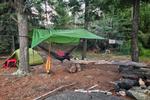
Once we were fully set up, we gathered wood and got the fire going to make the traditional first night burgers. A small tip if you like to have burgers. We use English muffins for buns. They are easy to pack, and handle being squished better than a normal burger bun. Once the burgers were ready, we popped open a tasty box of Bandit Cabernet Sauvignon, and commenced our relaxing. (Bandit is definitely my preferred box wine brand, and they come in one liter boxes, so you can split them up into multiple packs).


As the sun began to set we began to hear an intensifying buzz that could have passed for a freight train emerging from the woods. Before you could even make a break for the bug spray, we were inundated with swarms of mosquitoes. The mosquito horde that poured into camp, like Hannibal over the Alps, was easily the worst that I have experienced in the Boundary Waters. Slightly defeated, we make a mad dash for the tent. We were pretty beat from the day anyways, so it was probably for the best. 
 [paragraph break]
We had essentially nothing planned for the day, so we relaxed on the rock ledge, collected and chopped some firewood, and just enjoyed being on Ima lake on a beautiful sunny day.
Even Copper got into the spirit. 
As the day turned into evening, we prepped our delicious steaks, popped some popcorn and enjoyed another fantastic BWCA sunset.  [paragraph break]
  [paragraph break]
  [paragraph break] After the sun went down, the mosquitos returned with a vengeance, we tried to fight it, but they were so aggressive that they even bit through the bottom of the hammock! We again had to retreat to our tent. Thankfully we were well rested, so we managed to play a couple games of cribbage before packing it in. At some point in the night, I realized that my 20-year old Gander Mountain brand self-inflating sleeping mat had developed a hole and was completely flat. Unfortunately I did not have a patch kit along. (Mistake #5?) so I ended up using our life jackets for the remainder of the trip. Not ideal, but it could have been worse. In the end, the pad lining had separated completely from the foam, and developed several leaks, so there wouldn’t have been anything that could be done to save it.

After spending some time with our Loon visitor, it was time to finish what we started. We decided to make a day trip to Fraser. We packed our lunch in a single bag and headed out to find the portage to Hatchet Lake. As we crossed Ima, we noticed that most of the sites appeared to be occupied, including both Island sites. The sites on the island both looked really nice. The portage to Hatchet is well marked on the maps, but can be difficult to see, because it is all boulders.

A quick paddle across hatchet brought us to the ponds and river that leads to Thomas. Another map item to note is that there are 4 short portages between Hatchet and Thomas (not 3 as are shown on several maps). The paddle itself was pretty nice, and had some great views. We took our time, and it was refreshing to single portage, just carrying the canoe! 
As we crossed the final portage and caught our first view of Thomas, it took our breath away. The water was as smooth as glass (it turns out that it was the calm before the storm), and the lake goes on for what seems forever.

The wind really started picking up as we crossed Thomas, so I knew that we were going to have limited time on Fraser, but we slowly worked our way northeast towards Fraser. As soon as we hit the narrows, I knew it was worth all of the effort to get there. The narrows between Fraser and Thomas really are something to behold. It instantly moved into a top-5 place for me.  [paragraph break]
Sadly the weather continued to develop, so we pulled into an open campsite and cooked up some Zup’s Hot Dogs for our lunch. One little thing that I learned from my Dad was to always leave the fireplace with tinder and sticks set up and shielded from the elements if possible. That way if you get back to camp (or the next person gets to camp) and is in urgent need of a fire, it should be easy to get going very quickly. and loaded back into the canoe just as the rain began to fall. Thankfully we had the forethought to bring our rain gear. 
The return trip back to Ima was easy, until we hit Ima. By the time we were back on Ima, the wind had really picked up, and the light rain had turned into a solid rain. We worked our way along the southern shore back to our campsite, and made it in time to adjust our tarp to cover our seating area and fire pit. The rain let up a bit, and I was able to throw my line in the water to see if we could catch some fish.  Alas it was not to be, but to be honest, I wasn’t really trying all that hard. The rain picked up, and I checked the weather radio (another tip, a metal fly swatter handle can double as a weather radio antenna extension). Thankfully the weather wasn’t likely to turn severe, but they were now forecasting rain through the rest of the week.
We pretty much spent the day between checking my fishing pole, playing cribbage, reading, and making sure that we didn’t have to carry out any extra liquid (aka wine).  [paragraph break]
  We also had what turned out to be our favorite dinner of the trip. Pepperoni and Parmesan Tortellini.
  It is pretty easy to make. You need a tube of tomato paste, a packet of McCormick Spaghetti seasoning, a bag of dried tortellini, a stick of pepperoni, and some parmesan cheese. Cut up the pepperoni and fry it a little in a pan, make the spaghetti sauce, boil the tortellini, and combine it all together. Top with Parmesan.
The only problem is when you use your cup for food, you can't have it full of wine! [paragraph break] As evening fell, we had a decision to make. Our original plan was to pack up on Thursday morning and head back to Dissapointment, hoping to find a site for the last night that would be a quick exit on Friday morning. However, taking down wet tents and tarps, and then re-setting up wet tents and tarps are very low on my list of things I’d like to do. We made the decision that if the rain didn’t let up, we would head all the way back. 
The paddle across Ima was uneventful as the wind was pretty calm. We hit the first portage into Jordan, and with our new plan in place it went very smoothly. One less backpack was also a huge plus. [paragraph break] Our progress continued through Cattyman, Adventure, and on to Jitterbug, which seemed to be a very shallow lake, and you had to really look for the portage to Ahsub. It was full of lillypads and reeds. [paragraph break]
Ahsub takes you quickly to Disappointment. All of the portages are much wider than the northern route portages, and I would say easier too.[paragraph break]
As I reviewed the map before pushing off into Disappointment we took stock of our situation, and kept our decision to call it a trip and head all the way out, rather than stopping. The route through the many islands and turns (definitely a good idea to keep your map and compass very close by as you navigate Disappointment) was a beautiful paddle. I could definitely see the lake as a great first trip, or a for a nice trip with younger kids. 
We made it across Disappointment, and landed at the portage. At this point there is a decision to be made. In retrospect, we probably made the wrong one, given the weather. You can either take the southwesterly portage towards Parent Lake, which is shorter, but then you have one additional portage from Parent into Snowbank. If you go that route, you are more shielded from the open water, and can hug the eastern shore of snowbank a little better. When the weather is bad or there is a lot of wind, this is probably the better route to take. However, we had pretty much had our fill of portages by this point. So we opted westerly route, which is the single, longer portage from Disappointment to Snowbank. The portage itself was a little muddy due to the rain, but overall was wide, flat and fast. 
As we surveyed Snowbank Lake, we noticed that there were a few waves, but it didn’t look too bad. We loaded up and pushed off. As we came out into the section of the lake that is open to the north end, the wind was really picking up. We edged along as close as we could to the shore, but we had to ride out some pretty big waves on the way over to the landing. In retrospect, it might have been better to hold off a little while, but we successfully managed the crossing, and landed at the entry point at about 3:30. 
All in all, it was a fantastic adventure. We learned a lot,had a great time, snapped some memorable photos, and of course, took advantage of all the quiet and solitude that the BWCA can offer! As soon as we returned home, we immediately starting talking with our neighbors about joining us on our next trip in 2018 (Report to follow!) 
Bonus: If you have time before or after a BWCA trip out of Ely, I would highly recommend the short hiking trail to Kawishiwi Falls. The view is breathtaking. 
