BWCA Entry Point, Route, and Trip Report Blog
July 04 2025
Entry Point 52 - Brant Lake

Number of Permits per Day: 4
Elevation: 1500 feet
Latitude: 48.0692
Longitude: -90.8455
Brant to Tuscarora via Little Sag Route:
Round
Brant
Bat - Mud
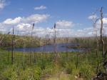
Gillis - burn area is evident:
French
Peter - first lake trout:

Virgin
Little Sag - green trees again!
Mora - gorgeous divide of burn and green
Crooked
Owl
Tuscarora - second lake trout!
Missing Link - with lighter food pack, the portage is OK
Round
Extreme
Entry Date:
September 24, 2010
Entry Point:
Moose/Portage River (north)
Number of Days:
4
Group Size:
2
Canoe: Minnesota II, stuck once on the damn beaver dam
New equipment: Ultra-plush sleeping pad, Kokatat paddling boots
Portages: 18 total, all terrain including one mucky exit
Sustenance: Contemplation, Starfire, salmon, sulfite-free gorp, pancakes
Stuff lost or almost lost: 1 jalapeño pepper to the fire, 1 headlamp and GPS – both rescued before fading into the abyss
Ultimate scenery: Curtain Falls, Ontario, Canada
Weather: 70s to below freezing, rain and 35 mph gusts, 2 sensational days, thunderstorms and a black wall cloud returning to civilization
Wildlife: Beaver, crawfish, duck, Canadian Gray Jay, eagle, grouse, hawk, one large loon, owl (heard), Pileated Woodpecker
Wildlife not seen: MOOSE – they were all hanging out at Oyster Lake
Etcetera: Neither chased by a bear or the Canadian border control Nina Moose Lake, Agnes, Lake 