BWCA Entry Point, Route, and Trip Report Blog
July 15 2025
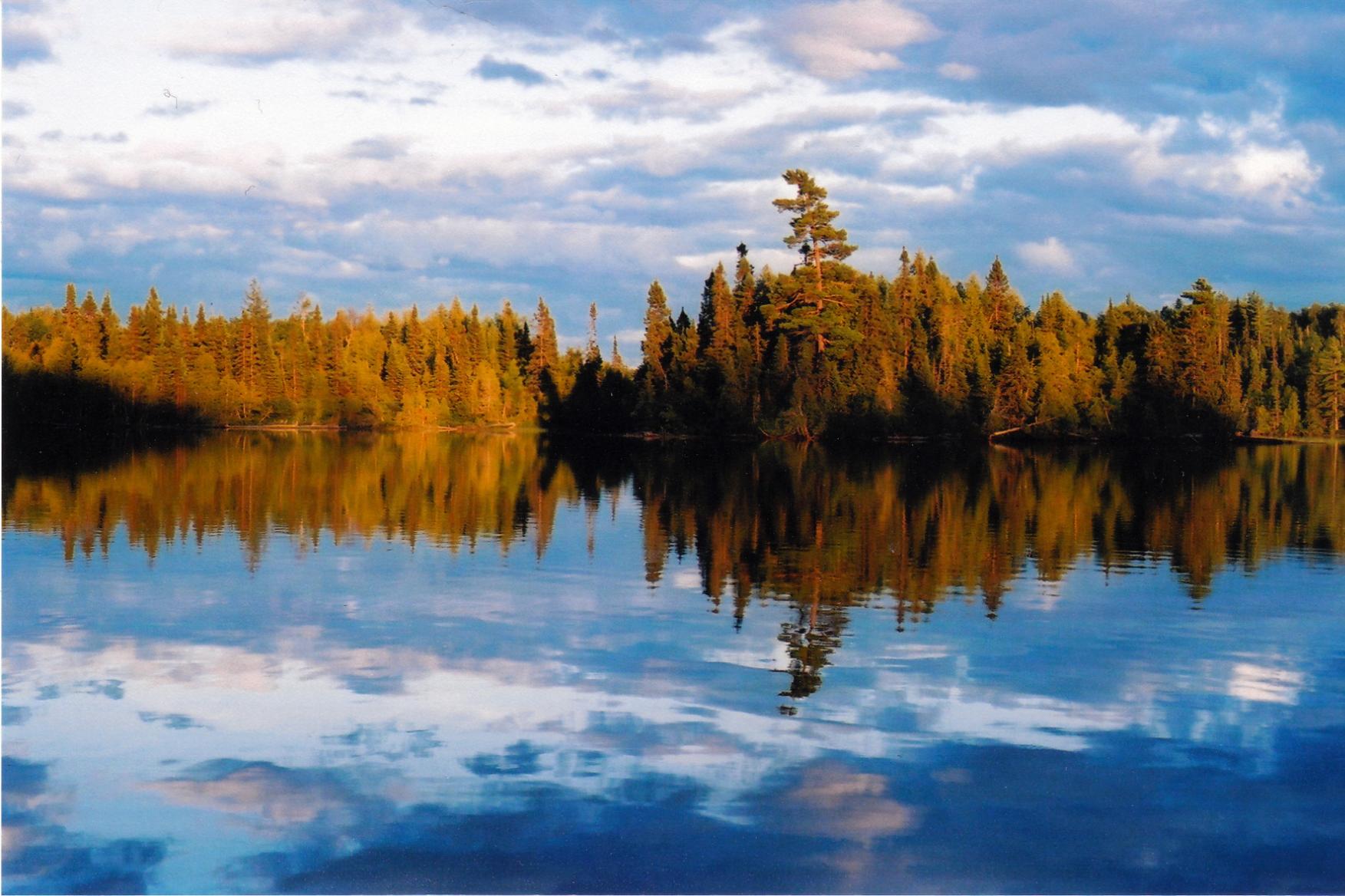
Entry Point 30 - Lake One

Number of Permits per Day: 13
Elevation: 1230 feet
Latitude: 47.9391
Longitude: -91.4792
My son Remy and I, and my friend Keith and his son Charlie put our canoes into Lake one at 9:30 Monday morning after dropping off a car at the Snowbank Lake landing. Lake One can be tricky to navigate. On our way to Lake Two we turned East too early and ended up paddling about a mile out of our way into a dead-end bay before we realized our mistake. We blamed the fact that Lake One was split between Fisher Maps #10 and #4 for our error. If the entire lake had been visible at once on a single map, we would not have made the wrong turn. Once we got back on course we portaged the 30 rods into a pond and then portaged the 40 rods into Lake Two. The weather was nice, and there was a bit of a tail wind out of the West. We stopped for lunch on the shore of Lake Two. After lunch we canoed through the North end of Lake Three and into Lake Four. We stopped for the night at a campsite on the West shore of Lake Four, just North of the channel heading toward Hudson Lake. We had to battle swarms of mosquitoes as we set up the tents. We then had a nice refreshing swim. Because we had brought steaks along for the first night, we didn't go fishing.
On Tuesday morning we had a bacon and eggs breakfast then packed up camp and headed out in our canoes. As we canoed past our campsite, we realized that Remy & I had left our hammocks pitched between trees. We landed again and quickly packed them up. Once again we had beautiful weather. We paddled East and completed 3 short portages before entering Hudson Lake. The 105 rod portage into Lake Insula was exhausting! Lake Insula is a large gorgeous lake broken up by multiple islands and penninsulas. We had lunch at a campsite on a large island just East of Hudson Lake. It felt like we had a tail wind as we were heading East, and then as we turned North it seemed like the wind shifted and was at our backs once again. We navigated Lake Insula flawlessly and camped for the night on the island just West of Williamson Island. After setting up the tents and a refreshing swim, Remy & I got back into the canoe and tried to catch some fish. We had no luck! At 9PM that night, just as we were going to bed, a thunderstorm rolled through. That night I was awakened several times by the loud croaking of bullfrogs from the shallows around our island. What noisy neighbors!
By Wednesday morning the weather had cleared, but the wind was now coming from the Northwest, pretty much in our faces. We paddled to the North end of Lake Insula and tackled the largest portage of our trip. The 180 rod walk to Kiana Lake actually seemed easier than the 105 rod carry into Lake Insula. We headed onward into Thomas Lake where we really started feeling the headwind. We finally made it to the campsite just Northeast of the portage into Thomas Pond in time for lunch. After lunch we proceeded across Thomas Pond and into Thomas Creek after hiking across the famous Kekekabic Trail. We managed to easily run the rapids in Thomas Creek and avoid the 2 short portages. We camped for the night on Hatchet Lake at the northern campsite. It was cool and windy, so we didn't swim. There was lots of threatening weather going by to the North of us, but we stayed dry. After supper we canoed back to Thomas Creek to fish and look for moose. No luck on either count, but we did see a beaver swimmming.
The weather was nice again Thursday morning, but the wind was out of the West which was the direction we were heading. We portaged into Ima Lake and canoed across it. Before portaging into Jordan Lake, we watched a bald eagle sitting in a tree get harrassed repeatedly by a seagull. The narrow channel leading into Jordan Lake is quite beautiful. It is narrow like a river with big rock outcroppings. We paddled across Jordan, Cattyman, Adventure, and Jitterbug Lakes. We found the Eastern campsite on Ahsub Lake taken, so we camped at the Western campsite which had a great place for swimming in front of it. There was a very brave loon in front of the campsite who didn't seem to mind if we got close to it. We tried our luck at fishing, but only caught 1 smallmouth which was too small to eat. Between 5:00 and 7:30 that evening we saw a number of canoes heading across Ahsub Lake from Disappointment Lake to Jitterbug Lake. We weren't sure where they were planning to camp, but it was getting late.
On Friday we awoke again to good weather. We paddled the length of Disappointment Lake and portaged into to Parent Lake and then on to Snowbank Lake. It was July 4th, and as we entered Snowbank Lake the sounfd of firecrackers reminded us we weren't in the wilderness anaymore. After a brief splash war on our way across Snowbank, we made it to the landing and our car was still there. What a great trip!
Bower Trout in early August
Entry Date:
August 03, 2009
Entry Point:
Bower Trout Lake
Number of Days:
6
Group Size:
5
We stop for a quick breakfast at Judy's in Two Harbors, and I perform the next ritual in the process- the symbolic removal of the watch. We are on woods time from now on. The drive up the shore passes quickly, and soon we're picking up our permit and watching the video. We pull into Grand Marais, and pick up the 2nd canoe at Beartrack Outfitter. A short "discussion" with the outfitter ensues...I always take a spare paddle just in case one breaks, and she insists that those are the ones that people leave behind at a portage. I give in, seems easier than forcing her to give me one. At least we have 1 spare for the 2 canoes, so we just go with the flow. Our entry point is only 20 miles up the Gunflint, and before you know it we're unloading gear and setting off down the portage. It's a little muddy, but there's a pretty nice boardwalk. Alex wanted to see if she could portage the lighter canoe- last time she couldn't even take one step. She trucked off down the portage, did the whole 80 rods. She was pretty pumped! We got ready to launch the canoes, and Alex stepped into what looked like a muddy spot alongside the boardwalk....and promptly sunk up to mid-thigh!  She kept on laughing, and off we went. Bower Trout is a pretty little lake, and we were stoked to explore it. We looked at the campsites...pretty small and we all agreed they would work in a pinch or for a solo, but not a group. Next stop, Marshall Lake. Another boardwalk/dock greeted us, and we prepared mentally for a muddy slog. As far as the new tevas go, the report is mixed. My toes and protected, but the mesh traps every little bit ot muddy stick next to my feet. Robin has a sweet pair of Keens that have open sides...looks like the way to go.
  By the time we hit Marshall, it was mid-day, and we cruised down the lake to the campsite. It's large, really beautiful, and we made it our own for the night. With Robin just learning to canoe, and Jesse still working on his steering skills, it made sense to take it slow and soak up the sights.
The campsite is surrounded by cedars, and has paths down to where the mouth of the Brule empties into Marshall...really pretty. it also has a beaver lodge close by. Towards dark we saw him swim by. We got into our routine of setting up camp- Robin set up her tent, Jesse set up our big tent and Jules' small one, and Alex and Jules went off to gather firewood. I set up the kitchen, got out snacks, and started getting ready to make dinner. Tonight was burgers, scalloped potatoes, and pnut butter brownies....yum!


After portage #2 we stop and pick blueberries- it has burned fairly recently in this area, and the crop is just ripening. We get enough that pie will be our dessert tonight. We head on our way and are passed by a group of young guys heading in to Swan, and resolve to pick up our speed a little. No one really wants to have to do that 281 rod portage into Vernon today! As a side note, they are heard saying "Good thing it's a rental" as they drop their aluminum canoe onto the rocks at the end of the portage. Grrrrr.....the canoe was rented from Rockwood. No excuse for that, IMHO.
We head across Swan...both sites on the point are taken, but the site in the bay is empty, and it's a beauty. Nice sized, plenty of tent pads, and a nice raspberry crop. We set up camp, and since we'll be here 2 nights, I decide to set up my new Granite Gear tarp....what a nice piece of gear! We have just finished cutting up firewood when a storm rolls in, and we all tuck ourselves under the tarp to wait it out.

As we are sitting there, a group comes from Vernon but turns when they see us...I feel bad for them, knowing hat there's nothing open until Marshall. The rain doesn't last long, and we're treated to an awesome double rainbow. 
The wind dies down, there's the most wonderful golden light....a photographer's wet dream...
Dinner tonight is curried chicken and rice, and blueberry pie. Absolutely amazing, if I do say so myself. Got to scrounge up some dehydrated coconut milk for next time! We sit up late around the fire, the moon rises, and robin says..."what's that noise?" It's the first notes of wolves howling! Sounds like they are JUST over the hill, they are really loud. I have to admit, when I walked back to the latrine, I had a crazy desire to bang some pots and pans, or at least whistle loudly. Kept telling myself that I was being silly, but there you go- even I can be psyched out by really close wolves. The fire burned down, we went to bed, another perfect day draws to a close.
Today is a travel day, we need to head back towards our entry point. By now we know that we travel fairly slowly, and that's ok. Breakfast is potato pancakes and apple sauce, not quite as good as homemade but still darn tasty. Alex does the dishes while the rest of us break camp.

We heaD BACK ACROSS SWAN TO THE 1ST PORTAGE- WHAT A PRETTY LITTLE LAKE! IT'S A NICE MORNING, SUNNY AND NOT TOO WINDY.

The portages don't seem as tough as the first time through- we are getting stronger. Makes me wish this was a 2 week trip! Jesse twisted his ankle yesterday, so Alex and I are doing most of the canoe portaging.Met Jeff from the message boards here with his wife or GF...didn't ask, but they were headed for Swan. We head back out past the windstorm and burn damage on Skidway and Dugout, and find the site on Marshall open again. Tonight we have a camp "pet" -this pretty butterfly who finds my new lifevest very attractive.

Camp setup has become pretty routine, and before you know it we're sitting down to our "last supper" of chicken wild rice soup and cheddar garlic biscuits. I snap a few photos of our crew around camp, and also this very cool plant that I'm not familiar with yet. Once I get home to my plant books it will be id'ed as "rose twisted stalk".


We get to bed early, before dark. Tomorrow I have to be in Duluth before 4 PM to do a radio show on KUMD.
Our final morning is cloudy and cool. I'm up just past dawn, and the coffee is ready along with a quick breakfast of biscuits and gravy. We get everything packed up, and pose for a group shot before hitting the water. 
Off we go, through the 1st portage and on to Bower Trout. The guys are ahead of the girl's canoe, and we see them stop paddling and start to drift. We catch up and Jesse says "Listen!" It is dead silent, just the occasional birdcall. So peaceful. "This is why we come here, isn't it?" he says. Damn. I must have done something right with that boy, I think.

Alex carries the heavy canoe on the last portage- that girl is a rockstar!

Soon the cars are loaded, and we're making our way back to the outfitter. I put my watch back on, and discover that we have time to either eat at Sven and Ole's or shower.....food wins. We have a darn good lunch, and drive back down the shore to Duluth. Another wonderful 5 days of memories, and another newbie caught hook, line and sinker!