BWCA Entry Point, Route, and Trip Report Blog
June 30 2025
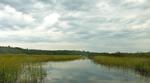
Entry Point 14 - Little Indian Sioux River North
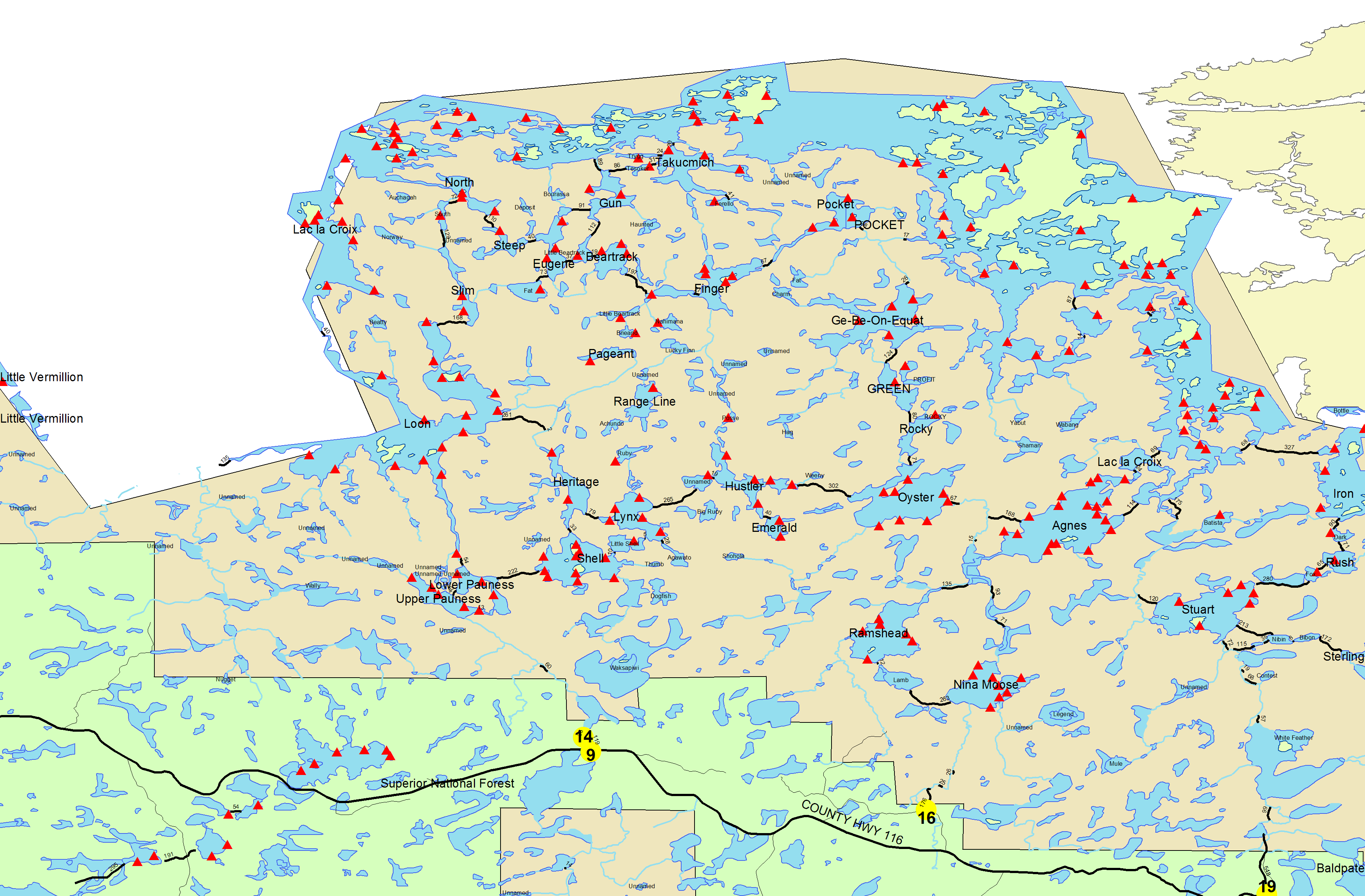
Number of Permits per Day: 6
Elevation: 1364 feet
Latitude: 48.1466
Longitude: -92.2103
September Morn
Entry Date:
September 03, 2012
Entry Point:
Moose/Portage River (north)
Exit Point:
Mudro Lake (23)
Number of Days:
10
Group Size:
6
A year ago in summer 2011, six of us commenced planning our first-ever, ten-day adventure in the Boundary Waters Canoe Area Wilderness, target launch Labor Day weekend 2012. Fulfills a four-decade dream of mine.
Our route: 50-mile grand tour, horseshoe loop Moose River (EP16), Lake Agnes, Iron Lake, Crooked Lake, Horse River to Horse Lake, exit Mudro Lake (EP 22/23). Start with two fairly tough days traveling to the Canadian border, followed by a leisurely week in the border lakes, culminating with two days paddling and portaging back to civilization. The goal was five travel days and five leisure days base camping.
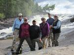
Our group: Three couples, aged 33-65. Lee and Terri, Rebecca and Kevin, Vickie and Roy. We exercised physically by practice-portaging heavy backpacks around home. Everybody did fine, although I wished I’d stretched each morning before traveling.
Provisions. Ten days requires a lot of food and drink. We toted nine 3-liter boxes of wine, weighing 55-60 pounds, equivalent to 36 bottles. Yes, the wine was heavy, but worth its weight! We were surprised how good freeze dried backpacking dinners tasted, and we enjoyed some fresh fish meals. Pike is not bad, despite “Y” bones. Pita bread was a hit. Mistake: cheap Babybel cheese instead of 10 ounce gouda cheese. Don't forget some candy!
Good gear. Weather radio (wind-up, no batteries), lightweight hatchet and saw, lightweight camp chairs, knife sharpener, long handled plastic spoons to stir freeze dried dinners, and coffee press. Regret not bringing jig heads heavier than ¼ ounce to fish deep on windy days. Roy and Vickie rented an 18’ ultralight kevlar Wenonah Champlain canoe. The Champlain is a wonderful canoe, stable, seaworthy, fairly maneuverable, and fast. Two couples brought smaller, heavier Royalex canoes from home. We pre-programmed a GPS with hundreds of campsites and portages, but didn’t consult GPS often enough to avoid a couple of wrong turns. Portable depth finder was nice (8 AA batteries) if you don’t mind the weight, extra batteries and pack space. The best map for planning purposes (not navigation) is the National Geographic Trails Illustrated map. For navigation, McKenzie maps seemed best.
Bugs are not bad in September. Most mosquitoes had already flown south, and I would have gotten more bug bites doing yardwork at home in Arkansas.
Suggestion. Choose at least one campsite with open view of the heavens on starry nights, many camps are in groves with partial views of the stars.
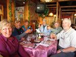
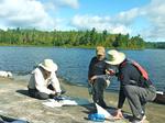
September 2, 2012 we left Harrison, Arkansas before dawn and drove 940 miles to Ely, Minnesota in one long day. On September 3, we joined the others for breakfast at an outdoor table at Taste of Ely, conveniently located next door to our outfitter Piragis. We met with the outfitter, picked up our permit, and toured the Wolf Center where one wolf loafed in the open ... We would see and hear his cousins a few nights later. We dropped our gear off at Piragis for tomorrow’s shuttle. The three men shuttled vehicles, parked two vehicles at the takeout point, and left our third vehicle at Piragis in Ely.
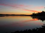
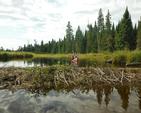
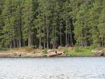
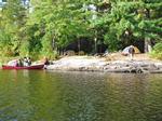
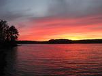
Day 1, September 4. Moose River to Lake Agnes (9 miles). It was a bright, sunny day. Our outfitter opens at 6AM and we were there! We boarded the van with three canoes and mountain of cargo, seemingly as much as Stanley’s expedition to find Livingstone. The driver drove us up the Echo Trail 28 miles to the Moose River Portage (entry point 16). We achieved an early 7:30 start, vital for claiming 5- star campsites. Our ten-day journey began with a portage of 152 rods (1/2 mile). We were excited and forgot to take a group photo. The men hoisted canoes and headed into the Northwoods, ladies donned packs and followed. We double-portaged throughout the journey, each making two trips to carry boats and gear along trails. The men always put on small packs and carried the canoes, then returned for larger packs. The ladies made two trips with packs and loose gear, paddles, fishing rods, and life vests. This first portage was level and rated easy, although no portage is easy with 40-80 pound packs. Roy’s main pack weighed possibly 80 pounds with six liters of wine. We laid down our heavy gear and congratulated ourselves for conquering the first portage. Moose River is a brook here in the woods. It was nice to put our canoes in water for the first time. Moose River is a pretty stream, flowing through the forest, the sky reflected on the surface like a mirror. We reached two shorter portages where the river formed rocky rapids. We lunched at a portage and Kevin fished the weedy shoreline, and caught the first fish of the trip: a small Northern Pike. We met only two groups paddling the first rivers. Vickie fell on loose gravel and skinned a knee. We paddled two miles down the river, and reached the first lake, Nina Moose Lake. We paddled quickly across this small lake. A lone trumpeter swan fed along the west shore; Kevin and Rebecca fished in some reeds with topwater lures. The second river, Nina Moose River, flows through a spacious marsh with cattails, reeds, and marsh grass, framed by forests in the distance. We paddled and portaged through the sunny marsh, and encountered beaver dams. Beaver dams are awkward obstacles often located near boot-sucking mud, and you must not lift a delicate Kevlar canoe with heavy baggage in the bottom. We paused and pondered a beaver dam with a three-foot drop. A traveler solo-paddling out of the wilderness offered tips on getting over beaver dams. Paddlers exit, drag the canoe over, stern paddler loads, backs out then comes in frontwards to pick up the bow paddler. We used the technique throughout the trip. When the horizon widened beyond the marsh and bordering forest, we knew Lake Agnes lay ahead. We paddled past boulders into Lake Agnes, a scenic two- mile long lake. I preselected a 5-star camp on a peninsula on the northeast shore (campsite 1803), and we were delighted the campsite was unoccupied. The camp is spacious, with abundant room for tents, and fine views in all directions. We arrived at 3:00, raised tents and hung the community tarp. It was sunny, before a shower rolled across the lake. We enjoyed our first boxes of wine under the tarp. The shower soon passed, the sun reemerged, we lit a fire and dined around the fireplace. Boundary Waters campsites have stone fire pits surrounded by elevated logs to sit on. We brought camp chairs for additional comfort. Our experience with the first freeze-dried meals was much better than expected. Tootsie Rolls were a big hit. Father and daughter rigged ropes and hauled our massive bundles of food into the pine boughs: this bear- rigging became a evening ritual. We brought so much food, we feared standing under the swaying bale of provisions. We heard wolves howling in the night,one vocal wolf with brief yips from the pack. Owls hooted often during our trip and geese honked at dawn. We saw the first of many loons and eagles, too many to recount. Loons called out throughout the nights, and we enjoyed our first sunset. Our first day was successful and satisfying: nine miles, five portages and several beaver dams.
Day 2, September 5. LAKE AGNES TO IRON LAKE (10 MILES). A STORM ROLLED OVER LAKE AGNES IN THE NIGHT. OUR EXPENSIVE GEAR PROVED ITSELF AND WE AWOKE WARM AND DRY TO A LIGHT RAIN. WE TOOK OUR TIME RISING AND PACKING, INASMUCH AS THE SECOND DAY AGENDA WAS EASIER THAN THE FIRST DAY. THE SKY WAS OVERCAST EARLY. EVERYONE WAS EAGER FOR THE SECOND TREK. IT SOON STOPPED RAINING, AND WE LAUNCHED CANOES, HEADING NORTH TO THE BORDER. WE PADDLED THE SHORT DISTANCE FROM CAMP TO THE “MUCK PORTAGE” TO BOULDER RIVER. THIS 118 ROD PORTAGE IS EASY IF YOU STAY SINGLE FILE IN THE MUDDY PART ON THE RIVER BANK. ROY AND REBECCA STRAYED OFF THE FIRM AREAS AND SANK UP TO HIP AND THIGH. THERE WAS ONLY ENOUGH FIRM GROUND TO LAUNCH ONE CANOE AT A TIME. LESSON LEARNED, DON’T STRAY "OFF PISTE" FROM THE PATHS. WE LAUNCHED INTO BOULDER RIVER, AND ADMIRED ITS BEAUTY. IF ONLY WE HAD TIME TO FISH FOR SMALLMOUTH BASS IN SHADOWS AROUND THE BOULDERS AND BLUFFS! THE SUN CAME OUT WHILE OUR THREE CANOES PLIED WINDING BOULDER RIVER AND BOULDER BAY. WE PADDLED PAST ISLANDS UNDER SUNNY SKIES AND COOL BREEZES, AND ENTERED LAC LA CROIX. ROY WAS ASTONISHED TO SEE FAMOUS LANDMARK WARRIOR HILL IMMEDIATELY VISIBLE ACROSS THE LAKE ON THE CANADIAN SIDE, AND REMARKED SEVERAL TIMES THAT MAPS MAKE THE BOUNDARY WATER SEEM LARGER THAN LIFE, RESULTING IN A COUPLE OF WRONG TURNS DURING THE JOURNEY. WE LUNCHED ON A TIGER BAY ISLAND WITH A WIDE GRANITE LANDING. THE SCENERY HERE IN THE EASTERN CORNER OF LAC LA CROIX IS WONDERFUL. WE PREVIOUSLY DECIDED NOT TO DETOUR WEST INTO LAC LA CROIX TO SEE THE PICTOGRAPHS OR ASCEND WARRIOR HILL. WE PADDLED NORTHEAST TO BOTTLE PORTAGE, IN CANADA, BUT U.S. AMERICANS ARE PERMITTED BY TREATY TO USE THE PORTAGE WITHOUT PASSPORTS OR PAPERS. BOTTLE PORTAGE IS LONG (80 RODS) STEEP, ROCKY WITH A MUDDY BOG AT THE END. KEVIN TOOK A WRONG TURN AND CLIMBED A STEEP HILL WITH HIS CANOE. DEER FLIES PATROLLED BOTTLE PORTAGE, ONE OF THE FEW TIMES MOSQUITOES AND THEIR KIN APPEARED. WE LAUNCHED INTO BOTTLE LAKE, AND PADDLED SOUTH INTO U.S. WATERS IN IRON LAKE. THE WEST WIND ROSE, SO WE PADDLED LEEWARD DOWN THE WEST SHORE. ROY PRESELECTED ANOTHER 5-STAR CAMP (CAMPSITE 1837) ON THE SOUTH END OF IRON LAKE NEAR PETERSON BAY. WE WERE HAPPY TO FIND THIS EXCELLENT CAMPSITE UNOCCUPIED. WE ARRIVED 3:30, AFTER PADDLING AND PORTAGING TEN MILES. WE PITCHED TENTS, SHORTLY BEFORE A BRIEF RAIN SHOWER PASSED. SECOND TIME WE FORTUITOUSLY WE SET UP CAMP BEFORE RAIN. THE SKY CLEARED, SOME OF US SWAM, AND A PLEASANT EVENING ENSUED. WE SPOTTED FIVE EAGLES THIS DAY; SO FAR WE SAW OTTERS, A SWAN, LOONS AND HEARD WOLVES HOWL, AND SAW MULTIPLE SETS OF WOLF FOOTPRINTS.
Day 3, September 6. Iron Lake. This campsite is superior, we made this a two- night base camp, and were tempted to stay longer. This campsite (1837) is the best of the four we camped, and is rated 5-stars for good reason. The view is wonderful, secluded bays and sunny islands, shady tent spaces among stately pines, with a tall fireplace with rock storage shelves for utensils, even surrounding mossy woods are lovely. We made pancakes, washed laundry and hung clothes to dry in the sun. We paddled into Iron Lake and fished walleye waters around the islands. Unfortunately, the wind blew canoes around the lake, and made it impossible to feel jig heads touch bottom in 20’ depths. Kevin caught two nice walleyes despite the wind, along with a 27” pike, and released smaller walleye and bass. Rebecca and Roy caught/released small walleye (Rebecca’s first), and Roy also caught a couple of small bass. Lee caught a whopper 19" smallmouth bass (released), plus a 28” pike (skillet). Dull knives and slimy pike made fish cleaning a challenge. We pulled out the sharpening stone belatedly. Kevin hooked Lee with a treble hook in the back of his jacket, thank goodness not in Lee’s hide. Terri prepared a big fish lunch of walleye and pike. Pike tastes pretty good, despite the small “Y” bones. It was a starry night.
Day 4, September 7. Iron Lake, Curtain Falls, to Crooked Lake (7 miles). The morning was overcast again, before the sun emerged mid-morning. The Iron Lake campsite is wonderful, but we wanted to paddle east while west winds prevailed lest the weather worsen or wind change. We launched 8:15, hoping to make miles across Crooked Lake before the wind became troublesome. Today, we saw two beaver, several eagles and Kevin & Rebecca saw a wolf at Iron Lake. Kevin, a country boy from Virginia, thought it was a big coyote. All three navigators inexplicably missed Three Island, resulting in a wrong turn into Canadian waters. Roy commented again that maps seem to exaggerate distances in the Boundary Waters (probably due to excessive hours he spent gazing at maps during the planning stage). Roy and Vickie viewed Rebecca Falls in Canada by accident, and received a scolding upon rejoining the group. We corrected course and reached Curtain Falls. Roy and Vickie made two portages while everyone else did one. Roy and Vickie followed outfitter advice to treat a Kevlar canoe like you own it, and portaged around some rocks where others could drag sturdy Royalex canoes. The main portage was 139 rods and rough. Another group coming the other direction offered to carry our gear when returning for the rest of their own gear. We found this helpful attitude consistent with others we met, but we didn't meet enough other parties to reciprocate and help others double- portage. The helpful guys had camped at Saturday Bay and one claimed catching a 23” small mouth bass, a real trophy. Curtain Falls is impressive: vast Crooked Lake thunders down a 45° slope and through a long series of chutes. We wished we had time to fish the turbulent water below each rapid. We reloaded our canoes on wide granite “beach”, and pushed off into Crooked Lake. We paddled south into Crooked Lake where the “days of the week” bays are located. A strong west wind was at our back and we made record time, perhaps 3½ mph. We practically sailed past Sunday Bay, and the only challenge was keeping the canoes pointed southeast. The wind was 10-15 mph and the white caps were small. Roy and Vickie were grateful for their 18’ rental canoe, much faster than our colleagues paddling smaller, heavier canoes. We stopped for lunch at a closed campsite north of Saturday Bay, after crossing the open waters of Crooked Lake. This campsite wasn’t marked on the map and we surmised its status was due to the steep, slick landing. Granite is not slippery when dry, but when granite is dark with moisture, look out below! Rebecca and Roy both lost their footing on damp boulders when re-entering canoes, dunking waste deep. The wind and sun dried out nylon and polyester duds quickly. We planned to camp in either Friday Bay or Thursday Bay, but found the first campsite in Friday Bay occupied. We continued east and found an island campsite between Friday and Thursday Bays (campsite 1871). This campsite was unrated on Roy’s map, and we gave it 4-stars. After previous 5-star campsites, this one seemed average. The camp features a grand old pine tree that made bear rigging easy. The view was good, but not spectacular, principally a view of a straight peninsula across a channel. At this point, we are over half way into our 50-mile loop.

Day 5, September 8. Crooked Lake. The stars appeared nightly. Roy awakened to see a star shining through the pines so brightly it reflected off the lake, and he initially mistook it for the moon. Morning dawned sunny with a mild wind, we thought. We ignored the weather radio prediction of 20% precipitation, and paddled into Friday Bay without rain gear. From the campsite we couldn’t see the big lake. The wind rose on the walleye shelves in the middle of Friday Bay, before a soaking rain. We retreated to camp bEFORE LUNCH TO DRY OUT. IT WAS A CLOUDY, DAMP, BREEZY DAY AND WE USED THE CAMPFIRE TO DRY THINGS OUT (VICKIE ROASTED ROY'S SOCKS TO "WELL DONE"). REBECCA CAUGHT THE ONLY KEEPER, AND ROY CAUGHT A 16” SMALLMOUTH BASS AND RELEASED IT. FISHING WAS DIFFICULT, BUT TERRI AND VICKIE ENJOYED A DAY IN CAMP. LEE DECIDED NEXT YEAR TO BRING HEAVIER FISHING GEAR, AND LONGER LEADERS TO THWART TOOTHY PIKE THAT STOLE $7 LURES. WE DECIDED TO STAY ONLY TWO NIGHTS HERE ON CROOKED LAKE, BETWEEN FRIDAY AND THURSDAY BAYS, DESPITE THE BIG-FISH REPUTATION OF THESE BAYS. WE WANTED TO PROCEED TO HORSE LAKE AND BASE CAMP THERE FOR A LONGER PERIOD. THE ONLY POSSIBLE OBSTACLE WOULD BE HORSE RIVER, AND VOYAGEURS SAID HORSE RIVER WAS LOW BUT PASSABLE. WE PLANNED TO CAMP A NIGHT AT LOWER BASSWOOD FALLS, AND THEN COMPLETE THE JOURNEY TO HORSE LAKE THE NEXT MORNING.

Day 6, September 9. Crooked Lake, Basswood River, Horse River, Horse Lake (15+ miles). The sky was bright and sunny, and we launched at 8:26. The long journey out of Crooked Lake up Basswood River is beautiful, and the weather enhanced the scenery ... tall granite bluffs and rocky points, dense forests, with alluring campsites along the way. We sped along, breeze at our backs, made excellent time and rested at famous Table Rock. We consulted maps and decided to keep trekking past the falls and make a marathon journey all the way to Horse Lake before nightfall. Horse Lake is “only” four miles past the falls. It would make an arduous day, but the prospect of a leisurely four nights and three full days on Horse Lake just a few hours from our exit point was appealing. We paddled along the pictographs painted on a rocky promontory on Basswood River. We soon found ourselves at Lower Basswood Falls, delighted at our rapid pace: 11 miles before lunch! Roy lost his PFD at Lower Basswood Falls. Happily, this $45 life vest was the single greatest loss of the whole trip! There are two portages at Lower Basswood Falls. Roy scouted the first portage, and deliberately left his PFD by the trail to return to the group. Meanwhile, the others embarked on the alternate portage. When Roy returned for his PFD 20 minutes later, it was gone. A man in a yellow kayak paddled away with the red PFD tied to his bow. We paddled all the way to Wheelbarrow Falls trying to catch up with the culprit, to no avail. Once again, we missed a turn into Horse River and paddled too far. No problem, just extra sightseeing miles. We located the mouth of Horse River among reeds and paddled upstream. The afternoon was cloudless, blue sky, warm sun. Horse River is another marsh stream, winding jade channel, golden marshes bordered by evergreen palisades, hills behind the tree line. The water was glassy and reflected the sky and timber line. The river is shallow, but easier than expected. We paddled through marshes to the first of three portages. The three documented portages are routine. By this time, we had paddled and portaged about 15 miles or more due to a wrong turn. We then learned why some pros do not recommend clients paddle Horse River, especially in low water. The final one-mile section from the third portage up to Horse Lake threads narrow, rocky fissures. Two couples dragged and lined their heavy, sturdy canoes through rocks without removing baggage. However, the delicate Kevlar canoe had to be emptied of heavy gear, and hoisted to avoid scraping and gashing on the granite. Roy and Vickie had already paddled 16-17 miles (including chasing the PFD thief), and these 5-6 granite drag-overs or mini-portages were exhausting. Roy was still lugging two boxes of wine, equivalent to eight bottles. Do we regret lugging all this heavy wine? No way! Spirits were high despite the long miles and repeated drag-overs. Rebecca and Terri proclaimed the Horse River Marathon rigorous, challenging, fun…a great workout. Lee compared the trip to a triathlon with paddling, portaging and pullovers. Finally we entered a broad marsh area, hopefully the lake, but we feared more obstacles. This outlet area was shallow, with boulders and weeds, but open lake came into view. The very first peninsula in Horse Lake is a long, narrow finger lined with pines: the 5-star camp (campsite 1116). We arrived 5:30 and pitched tents, some out on the windy peninsula, others in groves around the campfire. We were tired after 15-plus miles.
 Day 7, September 10. Horse Lake. We spent our final three days at Horse Lake. Our final exit trip will be an easy morning jaunt, so even if the weather deteriorates we can exit easily from this lake. Monday was a warm sunny day, but the winds gusted 20-25 mph. The guys went out fishing early and were expected back for a blueberry pancake lunch. Kevin gave up after 2 hours and we ate the promised flapjacks at noon. Lee and Roy did not return all morning. The ladies took this opportunity to sponge bath, wash hair and do laundry. The wind was out of the southwest; not the usual direction, but it made for a warm day and the laundry dried fast. This campsite had the most mosquitoes so far and the wind drove them away. We suppose their numbers are due to the neighboring marsh and the river outlet. Eventually, Vickie spied Lee and Roy through binoculars on an island, stranded 3½ hours waiting for the wind to calm down. Hunger overcame fear, so Lee and Roy braved the windy crossing back to camp. Roy caught his first pike (28”). Rodents did not trouble us the first week, to our surprise. Squirrels were preoccupied gathering pine cones, pausing only to scold us occasionally. We relaxed our guard, and a mouse got into the groceries for the first time. We bear-rigged the food every night, successfully. Roy was disappointed that gray jays didn't visit our camps ... gray jays were consuming berries along lake shores.
Day 8, September 11. Horse Lake. Another warm, beautiful day. We fished after eating blueberry pancakes with real maple syrup (yes, worth the extra weight). Windy again, but by the time we paddled to the south end of Horse Lake the wind diminished. Roy and Vickie fished a cove then headed out to islands for walleye. Again it was apparent we did not have heavy enough jigs to fish deep. Roy's spinning reel malfunctioned, ending his fishing. Lesson learned, bring an extra reel. Rebecca caught a 26” pike with her dad, Lee and Terri caught two 16” pike. Terri fried fish again for supper. We explored the north end of Horse Lake, impressed by the steep granite bluffs. Our campsite featured wonderful sunset views across the lake. Signs of autumn appeared in the forest, we watched one maple turn glowing orange during three days. A pair of loons patrolled around camp, possibly mother and sole surviving juvenile. One single loon regularly fished the south end of the lake.

Day 9, September 12. Horse Lake. Wind gusting 25-30 mph confined us to camp. Kevin and Lee made a brief excursion and caught a 27” pike and smaller pike. Tonight will be our last fish dinner. Vickie tired of picking out Y-bones and passed on the evening’s fish. We begin preparing for tomorrow’s departure. Amazing how fast ten days pass in the BW Wilderness. Terri thinks that two days in one place is plenty, and Vickie agreed. Vickie was bored with nothing to do in camp, too windy to play cards and her Kindle was wet. Roy’s SteriPEN got wet and temporarily stopped working. Lesson learned, secure electronics in waterproof bags…duh!
Day 10, September 13, last day in the wilderness, Horse Lake to Lake Mudro, exit 22/23. We anticipate paddling 4 miles with four portages equaling approximately 1 mile, with hot pizza and cold beer in Ely. We left early and paddled a mile to the end of Horse Lake. The southside loon accompanied Terri and Lee for a while, bidding us farewell. The first yellow colors of fall appeared everywhere now. The first portage was an easy 90 rods to Tin Can Mike Lake, a miniature version of Horse Lake. We paddled this small lake, and then made the second portage, ½ mile long but easy. We paddled across another small lake, Sandpit Lake. The third portage into Mudro Lake is the steepest of the journey, very rocky, mercifully only 50 rods long. It was the only portage some had difficulty with. After this "heart attack hill" portage, we expected the final stage to be easy. Wrong! Mudro Lake narrowed into a winding marsh stream. We met several parties coming the other way. The stream was so small and shallow we scraped and Roy frequently disembarked to drag the canoe through mud. Roy speculated why the National Forest Service didn’t just create a ½ mile portage around this marsh. The short portage trail through the marsh passed through a small grove then revealed the dusty road and parking lot of entry #22/23 around noon. Before long, we quaffed pints of beer at Ely Steak House and enjoyed hearty meals.
PROLOG
We were rookies, but well prepared. Spending ten days in BWCA was one of the best experiences of our assorted lives. Our wilderness route was approximately 50 miles, including 20 portages totaling 1,383 rods (4.3 miles). We actually paddled 70 miles or more counting fishing, exploration and wrong turns. The weather was excellent. There were a few brief rains, not enough to be dreary. A weather radio is useful and a 30% chance of rain usually means certainty. The only disappointment was wind on base camping days, making fishing challenging. However, several caught their first-ever walleyes and northern pike, we caught a bunch of 27"-28" pike, and Lee caught and released whopping 19” smallmouth. The stars and Milky Way were out at night, except we often camped in groves that partially obscured the heavens. We never had a northern view, so we could not see the Northern Lights if visible. We saw and heard wolves and wolf tracks, but no moose or bears.
Safe Journeys, Arkansas and Virginia Voyageurs