BWCA Entry Point, Route, and Trip Report Blog
January 26 2026
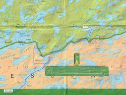
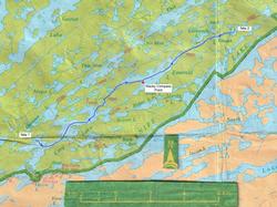
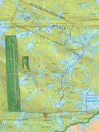
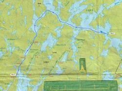
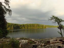
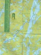
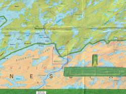
Entry Point 25 - Moose Lake

Number of Permits per Day: 27
Elevation: 1356 feet
Latitude: 47.9877
Longitude: -91.4997
Labor day weekend 2024.
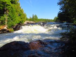
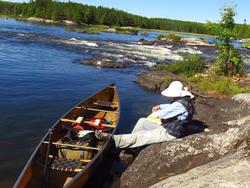
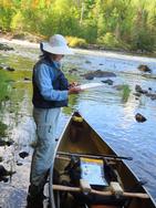
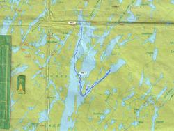
Entry point was 25-Moose lake. Went north, and then west onto Ensign Lake. Camped on eastern end of Ensign lake. Very busy and lucky to get a campsite. Day 2, went to Cattyman Falls and on down to Disappointment Lake. All sites full. Had to get off the water due to inclement storm. Ended up on Parent Lake on day 3, western camp site. Beautiful site. Exited from Snowbank lake on day 4. Overall fishing was poor. Some small mouth bass on Parent lake.
Nothing elsewhere. Approximately 20 miles of paddling/portaging. 11 portages in total. Already planning for 2025.
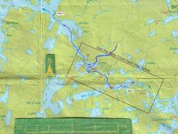
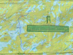
Quetico 2025, 10 Days of (Mostly) Solitude
Entry Date:
August 25, 2025
Entry Point:
Moose Lake
Number of Days:
10
Group Size:
2
Because we live in North Carolina, our Canoe Country trips start and end with a two-day commute between home and Ely that mapping apps list as some 1250 miles. That mileage doesn’t include stops for fuel, food, and lodging, nor does it capture the drive from Ely to Moose Lake. This year’s round-trip mileage was 2725 miles.
When we get to Ely, we're happy to get out of the car and get active again, so we checked into our room late yesterday afternoon, then walked around town to check out new canoes and other gear. We had dinner at the Boathouse (walleye baskets, of course), then returned to the room.
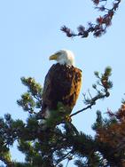
Day 1's breakfast was at Britton’s, where we each ate too much, then drove to the Moose Lake public landing. We were on the water at 8:50, and it's generally about a two-hour paddle from Moose Lake to Prairie Portage for us. In our first six miles or so of paddling, we had four bald eagle sightings!
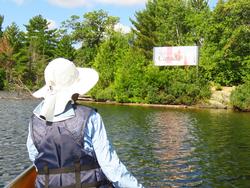
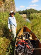
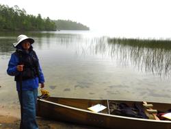
We left our gear on the Sucker Lake side of Prairie Portage and walked to the ranger station with our reservation information. The suspension of Canada’s RABC permits this year certainly impacted Quetico visitation from the south--we were one of only two parties entering Quetico via Prairie Portage August 25th, and usually all 15 of a day's PP permits are taken. We were quite happy we had saved that magic piece of paper from our 2024 trip! Our entry lake was Carp; the second party also had Carp as their entry lake and were already in the Park. With our signed reservation in hand, we walked back to the canoe and paddled the short distance on Sucker to Birch. After almost 4 miles (and a lunch stop) on Birch Lake, we portaged into Carp Lake. Our total gear weight the past couple years has been less than 125 pounds, so we're still single-walking portages, each carrying about 62 pounds at the start of a trip.
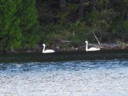
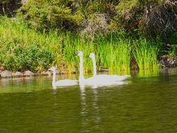
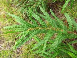
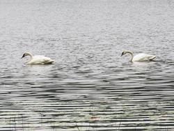
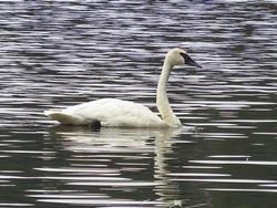
While the southern end of Carp Lake is on the US/Canada border, the bulk of the lake is in Quetico. We found a nice site on an island about a mile after leaving the border, filled the dirty reservoir of our gravity filter, and spotted a pair of trumpeter swans. We set up camp and our bear bag hang, and as I cooked our shrimp and pesto dinner, Tia was checking out flowers around the island. Blue asters, white asters, devil’s paint brush, buttercups, and grass-leaf goldenrod were still in bloom. As we cleaned our dinner dishes, a bald eagle flew in and landed in a tree at the edge of our site.
With food and smellables hanging, we retired to the tent around 7:30 with plans of a Patrick McManus story or two and a couple games of Farkle. Something happened when we crawled into the tent and stretched out horizontally for a minute—no stories or Farkle that night! We were both asleep by 7:45. Both awoke around 2:15 for a potty break and weren’t quite asleep when at 2:30 we were startled by a bright flash. I thought it might be getting northern lights, but it was too bright, almost like midday sun. After our trip, we learned that it was likely a bright meteor or fireball.
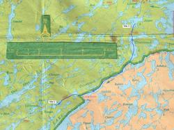
We awoke around 7:00 to a heavy dew, so we decided to take our time getting on the water in hopes of the tent drying some before packing. While eating our oatmeal breakfast, we watched an otter searching for breakfast and one of the swans flew into the cove where we’d seen them yesterday. We were on the water at 9:45, and it was a perfect day for paddling—calm water, blue sky, fluffy clouds, and just enough breeze to keep us cool. As we paddled into the upper bowl of Carp Lake, we passed an occupied campsite that may have been the other party that checked in yesterday, but saw no one. We paddled to the end of Carp and after some confusion caused by not paying attention to our maps & compasses, we lifted over a beaver dam and found the portage into Emerald Lake. If you’ve visited Emerald on a sunny day, you know how she got her name! As we paddled away from the portage, an otter swam across the lake in front of us, then disappeared into the brush. About a mile up Emerald we stopped for lunch at a campsite on a point. While reviewing her map, Tia thought her compass wasn't pointing north, but didn’t pay much attention to it. Back in the canoe after lunch, however, both our compasses did strange things, with the needles swinging back and forth as we left the point. When we were a hundred feet or so off the point, the needles settled, and we could orient our maps to get to the portage into Plough. Has any reader experienced this in Emerald (see map for location)? Any ideas about the cause? We wondered about significant iron deposits, or some big piece of logging equipment under water.
It appeared that the portage between Emerald and Plough saw far more moose than people in 2025. We saw moose tracks the full length of the portage, and the trail corridor was overgrown. Plough is a long, skinny lake, and we only knew of one campsite on it. While the site’s rating wasn’t so great, stopping at 3:20 made more sense than hitting an unfamiliar 810-meter portage that late in the day, so Plough was home for night two. Rain was in the forecast, so we took extra care to set up a dining fly and stow gear.
We had light rain overnight, but the rain had stopped and we saw patches of blue when we exited the tent at 6:45. We packed up a mostly-dry camp and paddled to the long portage between Plough and Ottertrack, another border lake. Like yesterday's portage into Plough, the portage appeared to have more moose than paddler traffic. The portage repeatedly climbed small hills, then dropped into drainages. About halfway through the portage we encountered a tree across the path that was too high to step over, too low to go under with a load, and too big for our saw. We unshouldered our loads and passed them under the tree before moving on.
We paused on Ottertrack to get a shot of a border monument, and a short time later we had to pull out rain gear. We stopped to check out the campsite we had originally planned for last night's stay, and were happy we'd stopped on Plough. As the light rain grew heavier, we donned rain pants and left the border portion of Ottertrack. We stopped for lunch at another campsite we'd marked on our maps, and considered stopping for the day rather than paddling on in the rain. But the site's landing was blocked by a fallen tree and it was a long walk up a hill to a tired and worn site, so we had a standing lunch in the rain and moved on.
The portage into Jasper wasn't far from our lunch stop, but its landing was tough to spot because of downed trees. We shouldered our loads and set off on what we thought was a 600 meter portage, but it ended after only about 40 meters—beavers at work! We put the canoe in the creek, loaded it, and paddled up the creek to another landing for the 'real' portage into Jasper. On Jasper we aimed our canoe toward an island site marked on our map. The site met our approval, and as we started unloading gear the rain stopped. After hot tea/coffee while setting up camp followed by a good meal and cheesecake dessert, we were warm, dry, and happy!
But the 'dry' became an issue: all through dinner thunder rumbled to the north, but the skies over our camp site were beautiful. We retired to the tent for Farkle competition, and the thunder came closer. As we started to read a couple stories from a Patrick McManus book it began to rain. Soon the rain and thunder were so loud we couldn't hear the reader, then the hard rain started spraying a fine mist through our aging tent's fly. The fine mist turned into some serious dripping from seams in the fly. Fortunately, the storm moved out after only 15 minutes, and we had been able to catch most drips with our bandanas, so we didn't get soaked inside the tent, and by 12:30 the sky was clear and beautiful. We'll put the dining fly over the tent for the rest of this trip!
This morning we were on the water shortly after 9:00 hoping to get most of the way through the Falls Chain. Our portage into Lilypad was uneventful, and we saw a pair of swans with a signet there. It took a couple passes to find the portage into the southwest arm of Saganagons, and the portage had several downed trees. We cut branches off one tree to make it easy to step over, and cut a small tree completely off the trail. At the end of the portage the trail was underwater, so we loaded the canoe and walked it to deeper water.
Saganagons is a big lake and it always takes us a few minutes to reset our navigation methods for places where we can't simply follow a shoreline. We had lunch on an island near Dead Man's Portage, and tackled the portage right after lunch. The next section of Saganagons can be particularly confusing with lots of islands and narrow passages that can be rock-filled and impassable in low water, but we got our bearings and entered the Falls Chain.
The Falls Chain is a favorite for paddlers and anglers, so we expected to see a couple dozen folks as we traversed the route. But this year we only saw two people in the entire Falls Chain. We met them on a portage, and they were the only people we had seen since leaving Birch Lake and the US border. I had hoped to make Kenny Lake before making camp, but we found a nice site on Sig, still three portages from Kenny, at 4:00, and called it a day. We dried wet rain gear, Tia caught up her journal, I set up dining fly ridge lines over the tent as well as over the cook area, and we had a great meal. The sky was cloudless.
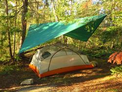
Sleeping without the fly on the tent, but protected by the dining fly was so nice we planned to do that the rest of the trip. We were up at 6:00 with hopes of working our way up Munroe Creek to a site on Mack Lake tonight and down the Wawiag River tomorrow—it's been 37 years since we've been on the Wawiag! We portaged around Little Falls, Koko Falls, and Canyon Falls without incident, although the Canyon Falls portage had some tough and rocky ascents and descents. We saw no one—no paddlers, no anglers, and no campsites. In Kenny Lake we turned up Munroe Creek, a wide creek with 'prairie' on each side. We eventually came to a pond of lily pads, lots of ducks, and a pair of swans.
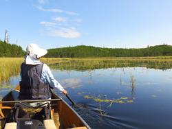
The pond was shallow, and the thick aquatic growth made paddling tough. We expected three portages in the first one-third of our day's planned travel, then four more portages to our campsite on Mack, but even after multiple beaver dam crossings while we paddled up and down the section of Munroe Creek above the pond, we couldn't find the first portage—just critter trails and a rock jumble of creek overflow. We decided to bail on the Wawiag idea and paddled back into Kenny for a late lunch stop. We may try again to get back on the Wawiag, but this year's route didn't include it.
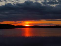
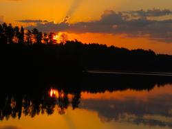
During lunch we studied maps and decided to continue to Kawnipi, then drop south. When we got back on the water, we portaged around Kennebas Falls into the Atkins Bay of Kawnipi Lake. We had several sites marked, and picked a suitable home for the evening on an island tip. Although the day had some disappointments, our efforts were rewarded with a beautiful sunset.
We slept great last night—our REI Helix insulated sleeping pads and 20* Big Agnes Greystone down bags have served us well. We were up at 6:00 for another long day. We had a light breeze during breakfast, and were concerned that it might become afternoon winds before we got off the big water of Kawnipi. Our plan was to travel to the southwest corner of Kawnipi and drop into Agnes. We were on the water at 8:30, and as we paddled west we saw eagles, swans, and ospreys. Around 11:15 we stopped for an early lunch on a small island below Rose Island. We had done no portages this morning and wanted to be well-fueled before hitting the three portages into Agnes.
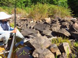
All three portages were challenging, with some marginal landings and some slick boulders to rock-hop across. The portage into Keewatin had huge blow-downs, and we were very thankful for the work of the portage crews. Without their efforts the portage would have been impassable. Keewatin has a nice pictograph site with thunderbirds, moose, stick figures, and abstracts. Visiting them made us think about checking out more pictograph sites and a petroglyph site on Agnes. The third portage had a few smaller trees blocking canoe clearance that we were able to trim back with our hand saw.
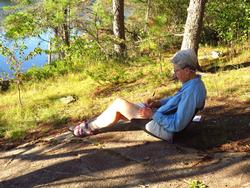
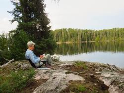
On a rocky point near the portage into Reid Lake from Agnes is one of my favorite campsites in Quetico, and (because we're still seeing almost no one in the Park) it was available for the night. We were there around 3:30, and before setting up camp we rinsed off in the lake. The site has a big patch of sweet fern, and Tia made an afternoon tea with a few leaves. Even brushing against the plant when walking through the campsite filled the air with its scent. Tia caught up her journal entries for the day.
It had been a beautiful day, but with the compromised tent fly, we set up ridge lines for the dining fly in both the cooking area and over the tent. Smart move—as we finished dinner cleanup, we started hearing thunder to the north and clouds started moving in. We moved the dining fly to the ridgeline over the tent, then played Farkle on a big rock with eastern views until a flash of lightning encouraged us to move into the tent. Eventually a gentle rain came, but moved past the site around 9:30. And it's been another private day in the Park.
We had another shower around 2:30 this morning, but the day dawned nice and sunny. Our plan for the day was to move down Agnes and check out several pictograph sites, then perhaps move on into Silence for the evening. Agnes had some breeze as we left the wonderful campsite, and the breeze picked up as we paddled. We saw a solo paddler across the lake this morning—the first person we've seen since passing the couple on the Falls Chain portage on Day 4. About 3.5 miles down Agnes we turned east below the largest of Agnes' islands and spotted a nice site on the island tip—that may be home for the night if no one grabs it before we get back (like that's been an issue this trip!). There was a picto site on the island south of us, and we were very pleased with the display: bear, canoes, hand smears, and more. We found the first picto site in the east arm, but even with a couple passes couldn't find the second one. We returned to the nice site on the tip of Anges' big island and claimed it for the night, even though it was only 1:00 when we returned. We sat outside the tent playing Farkle and reading Patrick McManus until time to work on dinner, then early to bed.
For the first time this trip, we awoke to overcast skies—nothing threatening, but it could mean rain later, and at 7:00 there was already a breeze. We were on the water at 8:30, and went past the picto site on the island south of us again, taking advantage of the lighter breeze than we had during yesterday's visit. We paddled toward the portage into Silence, knowing that the Park's only petroglyph site is north of the portage. There are more pictographs near the portage, as well.
The portage into Silence had poor landings at each end that warmed us up for the rest of the day's portages. Silence usually has a group or two camping, but no one today. We did spot a couple otters, though. The 350 meter portage from Silence into Sultry had a bit of everything 'portage': steep rocky climbs, rocky ledges, boulders on the trail, muck, mosquitoes—you name it! We stopped at a site on Sultry for lunch and agreed we'd have to be desperate to stay there. We pushed on through three more portages to Shade Lake. It was only 2:00, and we had decided that Shade was home for the night, so we explored four sites before selecting our home for the night. There's a picto site listed for the lake, but it's 15 meters or so from the shore, and we don't have good directions to it, so we set up camp and had a lazy afternoon.
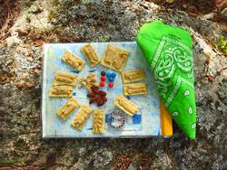
Our Quetico map-themed hors d'oeuvres tray!
Relaxing and enjoying our western view after dinner, we heard noise down the lake and saw a tandem canoe moving toward the site on the point across the lake from us. After a few minutes it was followed by a solo... then a tandem... then a solo... and a tandem. In 30 minutes we had seen more than twice as many people in the Park as in the previous seven days. The group pitched tents, started a couple fires, and the evening's silence ended.
Last night's neighbors weren't rowdy, but they stayed up very late. When I needed to get up at 3:30, they were still talking. Needless to say, we didn't hear a peep from them between getting up at 6:00 and getting on the water. I caught myself smiling when one of their poorly secured canoes drifted away from shore this morning; fortunately for them, it was caught in a shallow spot not far from their site.
The sky had a rosy glow this morning until the glow faded into a uniform gray—not threatening, but with potential for rain. We were on the water at 8:00. Our first two portages were short and had mostly good landings, although parts of the portage trails did require some careful foot placement. The landing for the long portage out of West Lake was marked by a couple Nalgene bottles that someone would miss—we carried them out. The sky turned darker as we walked this portage, which was terribly overgrown. Limbs slapped us and screeched across the canoe, then the rain began. In the no name at the end of the portage we were greeted by a pair of swans.
There are usually a couple beaver dams where one exits the no name between West Lake and North Bay and they were still there today. The first one had something of a walk-around, and the second was an easy lift-over into North Bay. I'm always concerned about wind on big water like North Bay, but today we only had a light breeze. We were both wearing rain coats under our life jackets for warmth—the rain we had on the long portage out of West Lake had stopped, but we still saw an occasional sprinkle. Shortly before the two portages into Burke, we spotted a bald eagle monitoring our progress from a pine top, and a couple more swans swam near the portage.
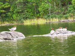
We planned a lunch stop on Burke, and looked unsuccessfully for a couple sites marked on our maps. We eventually stopped on an island site about halfway down the lake, and while eating lunch discussed the afternoon's plans. Most sites on Burke are tired and worn, so we considered moving through Singing Brook portage into Sunday Lake for the night. As we moved west on Burke, we spotted a small group of mergansers.
We checked out an island site on our way to the portage, and were pleased to find a lovely place to stay. Even though it was only 1:30, we decided we were home for the night, and would exit the Park tomorrow via the portage from Burke to Bayley Bay. The sky had been progressively bluer as we paddled this afternoon, but after 4:00 or so started getting grayer to the west, then we started hearing distant thunder. I strung up ridge lines for our proposed tent site and for our cooking area. As thunder sounded closer, we pitched the dining fly over the cooking area and stashed all other gear under cover. We cooked our 53rd anniversary dinner of shrimp creole under the dining fly, and were happy with the setup because about 20 minutes before it was ready wind and heavy rain reached the island. We stood under the fly eating dinner, then had cups of Key Lime cheesecake for dessert. The rain lasted about an hour, then was light enough to clean cooking gear, pitch the tent, and move the dining fly to the ridge line over the tent. As we entered the tent a second squall came through, but didn't last long. As the next day was our Canoe Country exit, it appeared that we'd be driving a couple days with a car full of wet gear.
Rain continued through the night, and more concerning, wind persisted. Fall has arrived—overnight low was around 45*, and as of 3:30 this afternoon hasn't reached 50*. We loaded the tent contents and took down the tent with the dining fly still over the tent pad. During a brief break in rain, we moved the dining fly to the ridge line over the cooking area and prepped breakfast. We were on the water by 8:15, wearing our warm layers and in full rain suits. Misty rain was blowing fog-like across the water in sheets. Our east-to-west travel on Burke was smooth, but when we reached the north-south leg of the lake we had whitecaps. Bailey Bay waited for us across the portage. More than once in our Quetico visits, Bayley had hammered us with big waves, and we were concerned about what we'd find at the end of the portage we've always referred to as 'The Boulevard'. Fortunately, the wind we had on Bayley was blowing in the direction we needed to go, and wasn't as strong as the wind on Burke.
We let the wind help us surf into Inlet Bay and made our way to Prairie Portage, where we stopped in the ranger station to ask Jason about the Munroe Creek route to Mack Lake and the Wawiag. He suggested that if we again pursue a Wawiag route, we work our way up the east boundary of the Park via Saganagons, Bitchu, Cullen, Monroe, and Mack Lakes. Something to think about.
The rain mostly ended at Prairie Portage, but the breeze persisted, and the sky stayed gray. Two more hours of paddling got us to the Moose Lake Public Landing. We've seen eagles, ducks, and geese today. A couple of the V-formations of geese must have had over 100 birds! At the car we donned dry socks & shoes, ate the remaining contents of our food bags, and loaded gear for the drive into Ely. We stopped at Spirit of the Wilderness to check in with US Customs. At Canoe On Inn we got clean, warm, and dry, then had a Highway 169 pizza at The Boathouse. Lights were out at 8:45.
It was another great visit to Canoe Country. We experienced mostly good weather, saw some new lakes, and collected ideas for another trip. During our ten days of Quetico 2025 travel, we saw 11 other people in the Park. We covered 105 miles, 99.5 by canoe and 5.5 via portage. The next two days will be on the road back to western North Carolina. During the drive we'll do a gear review (including discussions of a replacement tent!), a route review, a food review, and start thinking about our 2026 trip.