BWCA Entry Point, Route, and Trip Report Blog
July 03 2025
Entry Point 39 - Baker Lake

Baker Lake entry point allows overnight paddle only. This entry point is supported by Tofte Ranger Station near the city of Tofte, MN. The distance from ranger station to entry point is 26 miles. Access is a boat landing at Baker Lake with a 10-rod portage into Peterson Lake to reach first campsite. This area was affected by blowdown in 1999.
Number of Permits per Day: 2
Elevation: 1497 feet
Latitude: 47.8452
Longitude: -90.8169
Summary: A 5-day loop from Baker up the Temperance lakes to Cherokee, and back through Sawbill and Smoke lakes back to Baker. A fairly difficult trip.

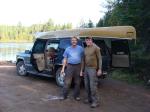
Day 0: We drove up from Stillwater in the morning and camped at one of the 5 walk-in campsites at Baker Lake, and it was nice.


Day 1 (Baker to S. Temperance) - A beautiful day, we decided to paddle all the way to South Temperance the first day which was a great paddle with easy portages except for the last one. We picked the campsite on top of a huge rock that was close to the middle of the lake. Tried fishing some but no luck


Day 2 (Rest) - In the night, we encountered the worst storm of the entire season. While we were there 19 people had to be rescued from the BWCA. We had about 50mph straightline winds, and I'm still surprised that the huge tent we had stood up to it. We slept in and took a rest day because of the intense winds. Amazingly beautiful sunset.


Day 3 (S. Temperance to Cherokee) - We left as early as we could to beat the heat, but it was no good. The lengthy, hilly portages were challenging and by the last portage we were pretty beat. We overpacked and single portaged which led us to speedier exhaustion. Still amazing weather. North Temperance was a beaut- I wish we had stayed there instead of South. We took the southeasterly facing campsite on Cherokee on the southeastern skinny island. Neat little site.

Day 4 (Cherokee to Sawbill) - Left a little later in the day but it was ok. We took our time going down the river letting out of the southwest part of Cherokee and it was a great area. BEWARE: The area between Ada and Skoop Lakes appears to be floatable, but a dam built recently has made the portion impossible to float. Be prepared for a long portage through muck and water. A guy that we saw there said he had been going to the BWCA for 40 years at least once per year and it was the worst portage he had ever seen. By the time we got to Sawbill it was pretty hot. We paddled all the way down to the site next to the portage onto Smoke.

Day 5 (Sawbill to Baker) - Cooler, cloudier weather for the first time on the trip. We were pretty hungry (I underpacked food a little and I felt really bad) and we were taunting each other with vivid descriptions of the burgers we were going to eat ASAP after getting out. We paddled back to Baker and returned our gear to Sawtooth outfitters.
Overall great route.
Number of Permits per Day: 2
Elevation: 1497 feet
Latitude: 47.8452
Longitude: -90.8169
Summary: A 5-day loop from Baker up the Temperance lakes to Cherokee, and back through Sawbill and Smoke lakes back to Baker. A fairly difficult trip.
Day 0: We drove up from Stillwater in the morning and camped at one of the 5 walk-in campsites at Baker Lake, and it was nice.
Day 1 (Baker to S. Temperance) - A beautiful day, we decided to paddle all the way to South Temperance the first day which was a great paddle with easy portages except for the last one. We picked the campsite on top of a huge rock that was close to the middle of the lake. Tried fishing some but no luck
Day 2 (Rest) - In the night, we encountered the worst storm of the entire season. While we were there 19 people had to be rescued from the BWCA. We had about 50mph straightline winds, and I'm still surprised that the huge tent we had stood up to it. We slept in and took a rest day because of the intense winds. Amazingly beautiful sunset.
Day 3 (S. Temperance to Cherokee) - We left as early as we could to beat the heat, but it was no good. The lengthy, hilly portages were challenging and by the last portage we were pretty beat. We overpacked and single portaged which led us to speedier exhaustion. Still amazing weather. North Temperance was a beaut- I wish we had stayed there instead of South. We took the southeasterly facing campsite on Cherokee on the southeastern skinny island. Neat little site.
Day 4 (Cherokee to Sawbill) - Left a little later in the day but it was ok. We took our time going down the river letting out of the southwest part of Cherokee and it was a great area. BEWARE: The area between Ada and Skoop Lakes appears to be floatable, but a dam built recently has made the portion impossible to float. Be prepared for a long portage through muck and water. A guy that we saw there said he had been going to the BWCA for 40 years at least once per year and it was the worst portage he had ever seen. By the time we got to Sawbill it was pretty hot. We paddled all the way down to the site next to the portage onto Smoke.
Day 5 (Sawbill to Baker) - Cooler, cloudier weather for the first time on the trip. We were pretty hungry (I underpacked food a little and I felt really bad) and we were taunting each other with vivid descriptions of the burgers we were going to eat ASAP after getting out. We paddled back to Baker and returned our gear to Sawtooth outfitters.
Overall great route.
The Namesake Trip - Davis/Frost loop
by cowdoc
Trip Report
Entry Date:
September 25, 2009
Entry Point:
Baker Lake
Number of Days:
8
Group Size:
2
Trip Introduction:
A few years ago, one of my tripping partners, Ted Davis, noticed the close proximity of Davis Lake to the lake that shares my last name, Frost Lake. The Davis/Frost loop idea was born but would take a while to become a reality. We finally got serious about it in the spring of 2009 and planning took place. It would be a fall trip and we decided on Baker Lake (ep 39) as a starting point. We agreed to not follow a tight agenda but instead to let the weather and our will dictate our travel. The tentative route would begin at Baker Lake, with an afternoon start, and head through South Temperance, Brule and the Cones to reach Davis Lake. From there, we would head somehow to Long Island and West to Frost Lake. After Frost, our travels would go through Cherokee to Sawbill and then finish up by going East through the Fire Chain back to the Temperance River and out again at Baker. I reserved a Baker Lake permit for September 25th and slowly over the summer we prepared for The Namesake Trip.
Day 1 of 8
Friday, September 25, 2009 The September weather had been gorgeous, a nice extension to an otherwise cool summer. It was warm, muggy and overcast when Ted picked me up at 5:30 a.m. A June trip up to the Gunflint had told me that it was about 7 1/2 hours to the Ranger Station in Tofte. We loaded the Tahoe and headed North through Madison to pick up the interstate. The drive up through Wisconsin was uneventful as the clouds parted, and by the time we reached Two Harbors, it was a clear, warm, breezy day. A Subway sandwich was topped off with a wedge of Blueberry alamode from Betty's Pies. We finished off our desert at a pull off rocky point and watched the waves crash over the Lake Superior shore. The wind off the big lake had a crispness to it that finally reminded us that it was September.
 By 2:00 we were watching the LNT video and grabbing our permit. The Ranger said that the nice weather had led to many campers and a slight fire concern. The pre-trip excitement grew as we headed up the Sawbill Trail. We were a little disappointed in the blandness of the fall colors. Evidently, the cool summer had delayed the onset of the brilliant oranges and gold's we were expecting in the Temperance River valley.
  After a few more dusty miles, the Baker Lake parking lot and landing appeared before us. The dozen or so vehicles there, and the presence of a few people wandering up to the campground, echoed the Ranger's prediction about people taking advantage of the lingering nice weather and squeezing in some late season canoe camping. We figured most of them were weekenders and as the afternoon unfolded our hunch proved correct. We unloaded, snapped some photos and were paddling by 3:15.
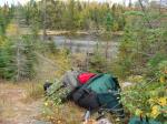
 As we started the first leg of our journey up through Peterson and Kelly Lakes, numerous daytrippers were heading out and we noticed all of the campsites were occupied. After the 72 rod portage into Jack Lake, the weekend "crowds" were left behind and we realized that darkness would approach quickly so we pulled into the first site we came to on Jack Lake. We had hoped to travel slightly further this first half day, but the low water levels had slightly increased the number and lengths of the first series of rocky portages on this stretch of the Temperance River. After surveying the campsite, we quickly went about our jobs to set up camp.
 As darkness settled in we dined on grilled steaks and fried potatoes to fill our bellies and lighten our food pack. It had been a warm day for late September, complete with more than expected sweat and even a few hard core mosquitoes, but the night was going to be cool, so we enjoyed a fireside toast to a good start and crawled into our sleeping bags at 9:30.
By 2:00 we were watching the LNT video and grabbing our permit. The Ranger said that the nice weather had led to many campers and a slight fire concern. The pre-trip excitement grew as we headed up the Sawbill Trail. We were a little disappointed in the blandness of the fall colors. Evidently, the cool summer had delayed the onset of the brilliant oranges and gold's we were expecting in the Temperance River valley. After a few more dusty miles, the Baker Lake parking lot and landing appeared before us. The dozen or so vehicles there, and the presence of a few people wandering up to the campground, echoed the Ranger's prediction about people taking advantage of the lingering nice weather and squeezing in some late season canoe camping. We figured most of them were weekenders and as the afternoon unfolded our hunch proved correct. We unloaded, snapped some photos and were paddling by 3:15. As we started the first leg of our journey up through Peterson and Kelly Lakes, numerous daytrippers were heading out and we noticed all of the campsites were occupied. After the 72 rod portage into Jack Lake, the weekend "crowds" were left behind and we realized that darkness would approach quickly so we pulled into the first site we came to on Jack Lake. We had hoped to travel slightly further this first half day, but the low water levels had slightly increased the number and lengths of the first series of rocky portages on this stretch of the Temperance River. After surveying the campsite, we quickly went about our jobs to set up camp. As darkness settled in we dined on grilled steaks and fried potatoes to fill our bellies and lighten our food pack. It had been a warm day for late September, complete with more than expected sweat and even a few hard core mosquitoes, but the night was going to be cool, so we enjoyed a fireside toast to a good start and crawled into our sleeping bags at 9:30.
Day 2 of 8
Saturday, September 26, 2009 Day two starts out with a hazy, cloudy morning on Jack Lake.  Temps are in the mid fifties with a 20% chance of morning showers. There is a slight southwest breeze that is pulling a little warmth into the day. There are a few beaver dams to cross and as we pass through Weird Lake, we soon come to the first little challenge of the day, the 240 rod portage up to South Temperance.
 It turns out to be a fairly flat, well used portage and we are soon looking over South Temperance, enjoying a snack and watching the wind increase from the West. This wind would be our friend as we head east to Brule and as we cross Brule and head up into Cone Bay. It is there that we meet a pair of kayakers, the first people since leaving Kelly Lake. There are campers on Middle Cone and daytrippers, on the short portage into North Cone, returning from a day of fishing on Winchell. I had come through this area in June and floated all the Cone portages but today we haul gear over all of them. After crossing North Cone, we find the lightly used, grass covered portage landing. This 176 rod portage is steep and rocky at the start before leveling off into a dark pine forest with a very open understory. Numerous game trails cross our path along the ridgetop before the trail eventually drops gradually down to the shore of Davis Lake. We pause for a brief celebration upon reaching this, our first namesake lake.
 It is then that we notice the west wind strengthening and the clouds gathering as a small front rolls in. The weather stays unsettled as we paddle West towards the mid-lake campsite on Davis and we arrive there around 4:30. The weather is just bluffing and things settle down as we set up camp and prepare some steak fajitas for supper.

 As the night gets calmer, it gets cooler. The fire feels good and as we are enjoying a nightcap, Ted notices a wake in the moonlight reflection. Suddenly a voice from the dark lake asks, "Do you know if there is anyone else at the other campsite?" Somewhat suprised, we take a while to reply that we doubt it and add that our mystery paddler is welcome to stay with us should the other site be occupied. As the fire burns out, Ted and I wonder what this paddler encountered on his trip into Davis in the dark. It was hard enough on us in the daylight. As it turns out, we never meet or see our mystery paddler again.
Temps are in the mid fifties with a 20% chance of morning showers. There is a slight southwest breeze that is pulling a little warmth into the day. There are a few beaver dams to cross and as we pass through Weird Lake, we soon come to the first little challenge of the day, the 240 rod portage up to South Temperance. It turns out to be a fairly flat, well used portage and we are soon looking over South Temperance, enjoying a snack and watching the wind increase from the West. This wind would be our friend as we head east to Brule and as we cross Brule and head up into Cone Bay. It is there that we meet a pair of kayakers, the first people since leaving Kelly Lake. There are campers on Middle Cone and daytrippers, on the short portage into North Cone, returning from a day of fishing on Winchell. I had come through this area in June and floated all the Cone portages but today we haul gear over all of them. After crossing North Cone, we find the lightly used, grass covered portage landing. This 176 rod portage is steep and rocky at the start before leveling off into a dark pine forest with a very open understory. Numerous game trails cross our path along the ridgetop before the trail eventually drops gradually down to the shore of Davis Lake. We pause for a brief celebration upon reaching this, our first namesake lake. It is then that we notice the west wind strengthening and the clouds gathering as a small front rolls in. The weather stays unsettled as we paddle West towards the mid-lake campsite on Davis and we arrive there around 4:30. The weather is just bluffing and things settle down as we set up camp and prepare some steak fajitas for supper. As the night gets calmer, it gets cooler. The fire feels good and as we are enjoying a nightcap, Ted notices a wake in the moonlight reflection. Suddenly a voice from the dark lake asks, "Do you know if there is anyone else at the other campsite?" Somewhat suprised, we take a while to reply that we doubt it and add that our mystery paddler is welcome to stay with us should the other site be occupied. As the fire burns out, Ted and I wonder what this paddler encountered on his trip into Davis in the dark. It was hard enough on us in the daylight. As it turns out, we never meet or see our mystery paddler again.
Day 3 of 8
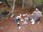
Sunday, September 27, 2009 There is a twist to this mornings weather as intermittent rain showers put a damper on breakfast. This was to be a layover day so Ted assembles our homemade reflector oven and bakes biscuits as I get the gravy mix started. 

 After cleanup we explore the campsite area and try a little fishing on the lee side of the penninsula. This midlake campsite is a nice one with a large, flat canoe landing out front. It is fairly open around the fire grate area, but has just enough trees to get a tarp up. There is a large, flat tent pad back in the woods that has room for a couple of decent sized tents. Being one of only two sites on a large, hard to reach lake, I think it would be a great site for a quiet summer basecamp. We retreat to the tarp to avoid the rain and listen to the weather radio to see how long this rain will last today. We discover that the showers may linger, but worse, 40 to 50 mph winds are predicted for late tonight and through tomorrow. A very quick decision is made to break camp and head for Long Island Lake. If not, we will be windbound here through tomorrow and will be way behind on our route, plus, we need a more protected site. Camp is ripped down, packed up and we hit the water at 12:30. The ever growing west wind blows us quickly east to our portage, the 320 rodder to Kiskadinna. As expected, this portage looks like it doesn't see much traffic. It is narrow, rocky and overgrown at the start before climbing to the ridgetop where it levels off. The big blow of 1999 must have hit this hilltop hard. There are only small trees up here with lots of brush and large areas of tall grass. Eventually we drop down through a large valley littered with a few moose bones, cross a small creek, and take a break overlooking a small unnamed lake.
 It has been too muggy to wear our raingear in the light drizzle but as soon as we finish a snack, we notice that the nagging precipitation is sinking in a little and the temps are dropping. We didn't realize this while grunting through this portage. The break is over and we squeeze down through a steep, narrow, rocky canyon, cross a boulder garden, pass another small lake and finally come to a creek valley and the log strewn portage landing on Kiskadinna. It has taken us two hours to leap frog across this portage and the weather is still deteriorating. So we put on raingear and make the short paddle across Kiskadinna.[paragraph break]We now have to psych up again for the 190 rod portage down to Muskeg Lake. I was here in June and I assure Ted that the worst part for us will be downhill. If you have never done "the wall" portage, I don't suggest trying it before or after the mile long portage to Davis. On we go through Muskeg Lake and the pretty little paddle through Muskeg Creek before hitting the large beaver dam at the start of the portage to Long Island.

 The wind is shifting to the North as we paddle into it and head for the island site on the East end of Long Island Lake. There is a decent landing out of the wind just below the site. It has taken us five hours to travel a little over four miles and we are happy to get out of the wind and water and set up camp. This is a nice camp on the tip of this island and we hope it will provide sanctuary for the next 36 hours. The firegrate area is nice, but is ignored by us as it sits on the point exposed to the wind. The tent is set back towards the trees behind a knoll and a grove of small pines. We angle the tarp low and right over the tent to deflect wind and rain. I use all the tie outs and we secure it to any and everything in sight. As we take a break to survey the rest of camp, we realize the temps are dropping and we are damp, tired and maybe on the verge of a slight case of hypothermia. It was a hard day to dress proper and the weather is catching up with us. A change of clothes and a hot cup of soup is just the ticket to give us the needed boost to finish off camp and prepare for the gusty night ahead. With camp set, some sausage is browned and thrown onto some sauce covered tortillas with cheese and we enjoy some BW pizzas. Sleep comes easily but I am jolted awake by the sudden, loud howl of the first big blast as it arrives.


After cleanup we explore the campsite area and try a little fishing on the lee side of the penninsula. This midlake campsite is a nice one with a large, flat canoe landing out front. It is fairly open around the fire grate area, but has just enough trees to get a tarp up. There is a large, flat tent pad back in the woods that has room for a couple of decent sized tents. Being one of only two sites on a large, hard to reach lake, I think it would be a great site for a quiet summer basecamp. We retreat to the tarp to avoid the rain and listen to the weather radio to see how long this rain will last today. We discover that the showers may linger, but worse, 40 to 50 mph winds are predicted for late tonight and through tomorrow. A very quick decision is made to break camp and head for Long Island Lake. If not, we will be windbound here through tomorrow and will be way behind on our route, plus, we need a more protected site. Camp is ripped down, packed up and we hit the water at 12:30. The ever growing west wind blows us quickly east to our portage, the 320 rodder to Kiskadinna. As expected, this portage looks like it doesn't see much traffic. It is narrow, rocky and overgrown at the start before climbing to the ridgetop where it levels off. The big blow of 1999 must have hit this hilltop hard. There are only small trees up here with lots of brush and large areas of tall grass. Eventually we drop down through a large valley littered with a few moose bones, cross a small creek, and take a break overlooking a small unnamed lake. It has been too muggy to wear our raingear in the light drizzle but as soon as we finish a snack, we notice that the nagging precipitation is sinking in a little and the temps are dropping. We didn't realize this while grunting through this portage. The break is over and we squeeze down through a steep, narrow, rocky canyon, cross a boulder garden, pass another small lake and finally come to a creek valley and the log strewn portage landing on Kiskadinna. It has taken us two hours to leap frog across this portage and the weather is still deteriorating. So we put on raingear and make the short paddle across Kiskadinna.[paragraph break]We now have to psych up again for the 190 rod portage down to Muskeg Lake. I was here in June and I assure Ted that the worst part for us will be downhill. If you have never done "the wall" portage, I don't suggest trying it before or after the mile long portage to Davis. On we go through Muskeg Lake and the pretty little paddle through Muskeg Creek before hitting the large beaver dam at the start of the portage to Long Island. The wind is shifting to the North as we paddle into it and head for the island site on the East end of Long Island Lake. There is a decent landing out of the wind just below the site. It has taken us five hours to travel a little over four miles and we are happy to get out of the wind and water and set up camp. This is a nice camp on the tip of this island and we hope it will provide sanctuary for the next 36 hours. The firegrate area is nice, but is ignored by us as it sits on the point exposed to the wind. The tent is set back towards the trees behind a knoll and a grove of small pines. We angle the tarp low and right over the tent to deflect wind and rain. I use all the tie outs and we secure it to any and everything in sight. As we take a break to survey the rest of camp, we realize the temps are dropping and we are damp, tired and maybe on the verge of a slight case of hypothermia. It was a hard day to dress proper and the weather is catching up with us. A change of clothes and a hot cup of soup is just the ticket to give us the needed boost to finish off camp and prepare for the gusty night ahead. With camp set, some sausage is browned and thrown onto some sauce covered tortillas with cheese and we enjoy some BW pizzas. Sleep comes easily but I am jolted awake by the sudden, loud howl of the first big blast as it arrives.
Day 4 of 8
Monday, September 28, 2009 The weatherman was quite right. There is a strong North wind in the morning with on/off rain showers. A small tent pad area back in the trees serves as our kitchen area as we cook up some pancakes and bacon. A gray jay stopped in to help with cleanup. 
 This island has some neat cliffs on its southeast side with numerous trails to explore out of the wind. I catch a few northerns from shore, nibble some trail mix and take a nap. The wind blows hard all day long with gusts easily into the 50 mph range. The weather radio has wind warnings in place until midnight and then decreasing into the morning. The plan is to let the wind die off on Tuesday morning, let things dry off and then head out for Frost Lake. After supper, sleep comes hard due to the wind and the lazy day.

This island has some neat cliffs on its southeast side with numerous trails to explore out of the wind. I catch a few northerns from shore, nibble some trail mix and take a nap. The wind blows hard all day long with gusts easily into the 50 mph range. The weather radio has wind warnings in place until midnight and then decreasing into the morning. The plan is to let the wind die off on Tuesday morning, let things dry off and then head out for Frost Lake. After supper, sleep comes hard due to the wind and the lazy day.
Day 5 of 8
Tuesday, September 29, 2009 It's still fairly windy in the morning but the clouds are parting and it looks like the sun is going to shine. An oatmeal breakfast is consumed slowly and camp is broke as the wind lessens and sun strengthens. Our paddle for Frost Lake starts at about 10:30. It turns into a sunny, crisp Fall day and the remaining Northeast breeze quartering from our rear makes the trip across Long Island fairly quick. We see a tandem canoe headed East and another group breaking camp. Leaving the Southwest corner of Long Island Lake, the Long Island River leads us to Gordon Lake and the 140 rod portage to Unload Lake. 
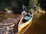

 This is a enjoyable portage with nice scenery, a few grouse, moose tracks and some interesting fungi.[paragraph break]
 It's a short hop from Unload to Frost and we paddle along the North shore inspecting campsites as we go. All are empty and we settle on the far North site with the big sand beach. The Souris River slides into the sand at 2:00 and we take advantage of the sun shining on the beach to hang all the damp gear and get things dried out and reorganized.

 The beach is the highlight of this site that sits tucked into the base of a ridge. There is a nice firepit area, decent tent space and a large cedar grove to the East. The beach campsite to the East would make a better summer site but this one seems cozier for late September. After camp is set, Ted and I take a little paddle and troll some spoons along some deep edges in search of Lake Trout. It's an iffy time of year to fish and the erratic weather hasn't helped us out either. Back at camp, we empty the clothesline, and make some spaghetti and bake some cheesebread in the reflector oven. It was a gorgeous autumn afternoon but the night is going to be calm and cold. The weather radio is calling for heavy frost warnings. We sit close to the fire as the moon shines across Frost Lake, the second half of our namesake lakes.

This is a enjoyable portage with nice scenery, a few grouse, moose tracks and some interesting fungi.[paragraph break] It's a short hop from Unload to Frost and we paddle along the North shore inspecting campsites as we go. All are empty and we settle on the far North site with the big sand beach. The Souris River slides into the sand at 2:00 and we take advantage of the sun shining on the beach to hang all the damp gear and get things dried out and reorganized. The beach is the highlight of this site that sits tucked into the base of a ridge. There is a nice firepit area, decent tent space and a large cedar grove to the East. The beach campsite to the East would make a better summer site but this one seems cozier for late September. After camp is set, Ted and I take a little paddle and troll some spoons along some deep edges in search of Lake Trout. It's an iffy time of year to fish and the erratic weather hasn't helped us out either. Back at camp, we empty the clothesline, and make some spaghetti and bake some cheesebread in the reflector oven. It was a gorgeous autumn afternoon but the night is going to be calm and cold. The weather radio is calling for heavy frost warnings. We sit close to the fire as the moon shines across Frost Lake, the second half of our namesake lakes.
Day 6 of 8
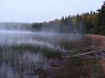
Wednesday, September 30, 2009 A sharp chill enters my sleeping bag and says "wake up!" Ted is an earlier riser and gets up also. The packs are covered with a heavy frost and the water filter line is froze. We decide to take an early morning hike and bushwhack over the ridge behind camp to a small, swampy lake to check for moose. They have left evidence of their presence on the beach. There are no moose out this morning so I head back out to the lake through the cedar grove and get some nice pictures of the fog as the air and lake play their games. 

 As we eat breakfast the fog thickens as the sun brightens it up before burning it off. At 10:00 we load the canoe and prepare to head back out to Gordon and down to Sawbill.[paragraph break]

 It's a beautiful fall day and the temps warm nicely as we paddle down Gordon and fish a little until we reach the portage to Cherokee. A young couple is arriving on the other side and we chat briefly. They have come from Sawbill way and mention that there are a few trees across some portages. We know why! Lunch is taken on a rock point at the mouth of Cherokee Creek. The paddle down the creek's black water provides a view of numerous rock outcroppings, beaver dams and a small patch of Pitcher plants with their dark red color.
 The wind has left its mark at the start of the 180 rod portage out of Cherokee Creek. A large spruce is down right across the landing. You can land the canoe but you can't unload packs. I toss the gear pack across the tangled mess and Ted crawls through and digs out his Gransfors camp axe. He clips off most of the branches and makes things passable for crawling over the trunk. There are a few more trees down along this portage that need pruning and we also crawl over a small landslide. Continuing on through Skoop, Ada, and Ada Creek, we arrive at Sawbill Lake and pick out a campsite on the East shore about halfway down the lake. It's an okay site on a small point and I recognize some islands to the West from some member photos on bwca.com. It's 5:00, light is fading and it's going to be frosty again. A chicken and dumpling supper is made by firelight and the cold night air puts us to sleep.


As we eat breakfast the fog thickens as the sun brightens it up before burning it off. At 10:00 we load the canoe and prepare to head back out to Gordon and down to Sawbill.[paragraph break] It's a beautiful fall day and the temps warm nicely as we paddle down Gordon and fish a little until we reach the portage to Cherokee. A young couple is arriving on the other side and we chat briefly. They have come from Sawbill way and mention that there are a few trees across some portages. We know why! Lunch is taken on a rock point at the mouth of Cherokee Creek. The paddle down the creek's black water provides a view of numerous rock outcroppings, beaver dams and a small patch of Pitcher plants with their dark red color. The wind has left its mark at the start of the 180 rod portage out of Cherokee Creek. A large spruce is down right across the landing. You can land the canoe but you can't unload packs. I toss the gear pack across the tangled mess and Ted crawls through and digs out his Gransfors camp axe. He clips off most of the branches and makes things passable for crawling over the trunk. There are a few more trees down along this portage that need pruning and we also crawl over a small landslide. Continuing on through Skoop, Ada, and Ada Creek, we arrive at Sawbill Lake and pick out a campsite on the East shore about halfway down the lake. It's an okay site on a small point and I recognize some islands to the West from some member photos on bwca.com. It's 5:00, light is fading and it's going to be frosty again. A chicken and dumpling supper is made by firelight and the cold night air puts us to sleep.
Day 7 of 8
Thursday, October 01, 2009 Another frosty morning greets us on this our last travel day. 
 After a quick breakfast we head down Sawbill into a fairly stiff wind and find the portage to Smoke. There are a few more trees down on this portage and for the first time, we share the portage with other paddlers. A pair of fishermen are headed for Burnt and a solo paddler is watching the wind and not making predictions. After Smoke, we portage into Burnt and fight a stiff crosswind to reach the other side.
  Our final trail lunch is served at the start of the 230 rod portage which takes us about an hour to cross. This will be our last big portage as we complete our loop back to the Temperance River drainage.[paragraph break]
 The south wind makes it a hard paddle back down Kelly and Peterson. We meet a few moose hunters hauling in gear for the upcoming hunt and we wish them good luck. The canoe pulls into the Baker Lake landing around 3:00 and the Namesake trip is complete. A firm handshake seals the deal between two friends and time well spent in canoe country.
  [paragraph break]After packing up, I suggest we head up and check out Sawbill campground and Outfitters for future trips and purchase a cold beverage ;) Afterwards, we head back down the Trail to Tofte and we notice that there is quite a bit more color in the Temperance River Valley. I guess we saw Fall arrive.
 We grab a room at the Americinn and after cleaning up, head out for a bite to eat at the Trestle Inn. Stopping back in Tofte at the Bluefin for a nightcap (we were tired of going to bed at 9:30!), we learn from the barkeep that the windstorm knocked power out for most of Monday in Tofte and other places along 61.
After a quick breakfast we head down Sawbill into a fairly stiff wind and find the portage to Smoke. There are a few more trees down on this portage and for the first time, we share the portage with other paddlers. A pair of fishermen are headed for Burnt and a solo paddler is watching the wind and not making predictions. After Smoke, we portage into Burnt and fight a stiff crosswind to reach the other side. Our final trail lunch is served at the start of the 230 rod portage which takes us about an hour to cross. This will be our last big portage as we complete our loop back to the Temperance River drainage.[paragraph break] The south wind makes it a hard paddle back down Kelly and Peterson. We meet a few moose hunters hauling in gear for the upcoming hunt and we wish them good luck. The canoe pulls into the Baker Lake landing around 3:00 and the Namesake trip is complete. A firm handshake seals the deal between two friends and time well spent in canoe country. [paragraph break]After packing up, I suggest we head up and check out Sawbill campground and Outfitters for future trips and purchase a cold beverage ;) Afterwards, we head back down the Trail to Tofte and we notice that there is quite a bit more color in the Temperance River Valley. I guess we saw Fall arrive. We grab a room at the Americinn and after cleaning up, head out for a bite to eat at the Trestle Inn. Stopping back in Tofte at the Bluefin for a nightcap (we were tired of going to bed at 9:30!), we learn from the barkeep that the windstorm knocked power out for most of Monday in Tofte and other places along 61.
Day 8 of 8
Friday, October 02, 2009 The wind is blowing hard again this morning as we head for home. Highway 61 is wet in places from the spray off the lake. A lone wolf crosses the road on his way down to the lake just South of Tofte. I take it as a good sign to the end of a great Namesake Trip. 
discuss this trip report (25 comments) - last post on April 14, 2010