BWCA Entry Point, Route, and Trip Report Blog
June 30 2025
Entry Point 38 - Sawbill Lake

Number of Permits per Day: 11
Elevation: 1802 feet
Latitude: 47.8699
Longitude: -90.8858
Sawbill Lake - 38
Detour to Chad
Entry Date:
September 04, 2015
Entry Point:
Trout Lake
Number of Days:
4
Group Size:
3
We entered the eastern side of Vermilion around 8am with hopes to get is far up Trout lake as we could on day 1. Luckily we had some strong winds going with us and we were able to cover 15 miles on big water. We reach Little Trout Lake around 3pm hoping to stay on the island on the north end of the lake. We make our way up and find that there is no sign of a campsite at all. I really should have done my homework, because I now clearly see that no one has ever rated this site before.. We check the NW site and it's already in use, which was a bummer because the next closest site is on the exact opposite side of the lake. We paddle into heavy winds across and to our delight find an open site to claim. It's a pretty simply small site, but there is a nice sandy beach to take a dip in after a long day of paddling. We drift off into the night with hopes to hop on the LIS river in the morning and make it all the way to Cummings...or so we hope. 

We get up at dawn and set out for the LIS. The portage is shown on maps to be in the NE corner of Little Trout Lake, but we have a really hard time finding it. We find what appears to be some sort of path, although it looks like no one has used it in over 10 years. It is severely over-grown and feels like we are hiking through thick woods rather than a portage. Many fallen trees. We're about half way to LIS when the poratge suddenly stops. We drop our canoes and explore the area. Nothing. No path to be found in any direction. We feel like we've been fooled. We all explore deeper in the woods towards where we expect the LIS would be, but we end up finding nothing. Now we must make our way back to our canoe..not an easy task after we had taken so many turns in thick woods.. we really made a rookie mistake not marking our route. I admittedly feel very worried. We had been lost on the portage for over an hour now and we were without water on what was a scorching hot day. Finally after frantically combing through the woods one of us sees our canoe and we all yell out a big Wohoo! Now we're back to ground zero. Still haven't found the portage. Our new plan is to leave someone at the canoe as two of us venture back out. Hunter and I, follow what appears to be a path near where we initially got lost. We follow this path for what seems to be an eternity and sure enough at the very end lies a calm marshy LIS river. We hike back and yell to Kyle to let him know we've found it. Onwards. Holy hell that portage was long.
Now we're on the LIS after losing about 2 hours of our day. Waters were low, and the LIS is moving at a snails pace. We paddle for a couple hours and realize we may not make Cummings before sundown. We grab our map and see a small creek that leads to nearby Chad Lake. This appears to be our best option, so we go with it.
Boy, were we in for a treat. This so-called creek was more marsh than anything. I'll bet we had to hop over 20 beaver dams; which we got pretty good at by the end! The creek was so windy our long 3-person canoe couldn't make all the tight turns - so we had to improvise quite a bit. At some points it was so dry we couldn't even paddle. Two of us ended up getting out and standing in the waist high mush and tugging along the canoe. I don't even want to know what sort of living creatures lurked below. It was hard to tell how far we had gone, because of how windy it had been..we'd look ahead and it appeared to be a never ending doom in both directions. We pondered going back towards LIS because the creek wasn't getting any better. I'll be honest it was the most frightened I'd ever been in my life. Each turn we made in the creek was like a new nightmare. We moved about as slow as paint drys. With the sun going down and no lake in sight, all we had was each others hope to lean on. Alas! We see lake in the horizon. The best feeling I've ever had. We were hooting and hollering so damn loud. Like any good ending we make it to Chad lake. We're so beat, so we b-line to the nearest site on the NW side of the lake. It's beautiful. So damn beautiful. There's a peninsula to look out on, deep waters to swim in. We're in heaven. We decide to stay here for the remainder of our trip. Good night moon. 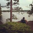


We break down camp around dawn and venture back to Trout Lake via Pine Creek. Luckily Hunter's brother met us on Vermilion to tow us back to our car. We made decent time.
All-in-all it was a good trip. It didn't go as planned, but that's how it goes up there. Our mantra for the weekend was 'you never know in the bdub'...oh so true.
Till next time!