BWCA Entry Point, Route, and Trip Report Blog
April 06 2026
Entry Point 1 - Trout Lake

Number of Permits per Day: 12
Elevation: 1381 feet
Latitude: 47.9144
Longitude: -92.3220
Trout Lake - 1
Fine Wine north of Sawbill
Entry Date:
May 15, 2010
Entry Point:
Sawbill Lake
Number of Days:
5
Group Size:
2
I met Kelly in Rice at about 1:30. We drove up separately since I would be spending the whole week up north. Kelly had to head back home on Wednesday morning. A few buddies from work would meet me at the Baker lake campground on Wednesday to do some fishing. But that's another story.[paragraph break]
It was the Friday before the fishing opener. We hoped to avoid Duluth and the massive road construction project on I-35. We decided to get well off the beaten track. Taking highway 13 north just before Proctor. Then took hwy 9 east til hwy 37 north then NE on hwy 44 all the way to Rollins. Then east on 55 (which turns into 14 at the Lake county line). Hwy 2 north to 15 then 402 (Lax lake road). From there we headed to Finland and came down 6 to Little Marais on 61. I bet we only seen a handful of cars after hitting 37! Better yet. We figured we only lost about 20 minutes off our normal time to get to Tofte. [paragraph break]
We stopped at the Holiday in Tofte to fuel up and grab some food for that evening. And since we wanted to get an early start in the morning, we also grabbed some pop-tarts and sandwiches for a quick easy breakfast.[paragraph break]
It rained a little off and on as we headed up the Sawbill trail. Arriving at Sawbill Outfitters to pick up our permit and get a campsite for the evening we were told that the fire ban had been lifted as of noon that day. We were keyed up already, but that was some welcome good news as well. We ate our supper and enjoyed a cool evening with a nice fire and a few beers.
We woke early Saturday to a very cool & crisp morning. We actually ate our breakfast in the vehicle with the heater on. There was hardly a cloud in the sky and as the sun rose the temperature climbed quickly.[paragraph break]
 The lake had a beautiful mist blanketing it. It was still before 7:00 and there was quite a bit of activity at the landing. Before we knew it the Black Pearl was cutting glass across a mirror named Sawbill. There were also several canoes about once we were out on the lake. We joked there was more traffic here than we had seen on the way up.[paragraph break]
Once we started heading north towards the Kelso river portage we began to separate ourselves from the "crowd". We spotted a bald eagle. I tried to take a picture, but it seemed everytime we were about to get close enough it would take off and fly further up the lake. This continued all the way to the Kelso river portage. I guess Ol' Baldy was acting as our guide?[paragraph break]
As expected, the portage to the Kelso river was across an excellent wide flat trail. There was a small little stream running along the northside of the trail. We started on again in a swampy/boggy looking area. Kelly mentioned he hadn't seen a moose in his several trips up here. And rightly figured this was prime time & habitat for seeing one. We were quiet, and kept a sharp eye, but no moose was seen today. [paragraph break]
According to my map, the Kelso river looked a bit trickier to navigate than it actually was. It appears that there is a fork in the river about half way between Kelso lake and Lujenida lake. Being as narrow and winding as the Kelso river is, that it might be easy to start heading up the wrong fork? We encountered no such problem coming or going. Never even noticed where the fork was. [paragraph break]
We hardly recognized when the river became Lujenida lake. Before we knew it we were at the start of the portage that had been inexorably transfixed on our minds the last few days. The portage started off with a long, not too steep, gradual climb. This type of terrain repeated itself several times over the course of the long trail.  There were several boardwalks constructed over most of the wet areas. Generally speaking, the trail was a well worn undulating path with only one short tough climb at about the halfway point. The real problem was that the trail had not yet been cleared of downed trees etc. Most were easily traversed over. Naturally the 3 worst ones were on the steepest hill. The only way to pass was to set the canoe down and slide it under 2 of those trees, then crawl on hands and knees with the packs. We double portaged it, so on the way back I pulled out my camera.

 [paragraph break]
Mercifully we finally finished. I would rate this portage on par with the Missing Link - Tuscarora portage. Maybe just a bit easier if not for all the downed trees. We took a break and caught our breath while enjoying a well deserved cool drink.  [paragraph break]
We pressed on down the stream between Zenith and Frederick. There are a myriad of different potential routes as this waterway is more maze than river.  We seen a hawk perched on a small branch just before having to pull over a small beaver dam. My Voyageur map didn't show it. But there is, what I'm guessing to be a 7-8 rod portage between Zenith and Frederick. This may be shorter in higher water??? But Im think it will almost always be necessary. It is a very poor trail and the Frederick end is espescially rocky.
  Kelly wound up taking a nasty fall while trying to set a pack in the canoe. While he did end up with some bad scars and scratches, fortunately there was no serious injury. I took this as a sign that the long portage had really wiped us out. There was a campsite on Frederick. We decided to stop there and rest before making our final push into Wine.[paragraph break]
The site was slightly elevated and had a decent view of the lake.  It was a nice spot to pull off and take a break. Though the overnight camping ammenities were, at best, sparse. We pulled out the trail mix and sat down to catch our breath. The original plan was to head for the island site on Wine. I mentioned that the site nearest the portage was also supposed to be a nice one. I suggested that we grab that one & save ourselves an extra mile or so of paddling. [paragraph break]
We paddled across Frederick to the portage. A couple of rods up the trail, there stood 2 large white pines that the trail ran between. 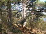 They appeared to be 2 sentinels guarding the gateway that must be passed through in order to enter Wine lake. The trail itself started with a moderate climb on a decent dry trail before leveling off. About midway there was a short up and down then a steep decent on a rockier trail down to Wine.
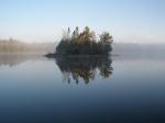
  There was a decent overlook of Wine at the top of the trail before the steep decent to the shore.[paragraph break] We loaded up and pressed on to the nearest campsite only to find it occupied! These were the first people we had seen since Sawbill. With no choice but to paddle on we headed for the island site. I was somewhat surprised at just how narrow the channel was on the north end separating the 2 lobes of Wine. Every map I've seen of this lake shows the campsite to be on the east side of the island. The WEST side is where you'll want to head if looking for the landing. [paragraph break] I had heard this was supposed to be a nice site. At this point we would've grabbed virtually any established site with flat ground. The site was all we could've hoped for. Without fully taking the time to enjoy how nice it was, we quickly set about getting camp set up, chopping firewood, and preparing supper. The brats we had were among the best I'd ever tasted.LOL
 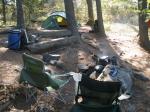 It would prove to be an early evening for us. We both hit the bags just as the sun was going down. [paragraph break]
Sawbill Lake, Kelso Lake, Lujenida Lake, Zenith Lake, Frederick Lake, Wine Lake
We got up early and had a breakfast of pancakes. Once again it was shaping up to be a warm day with little or no wind.  We liked our camp so much that we made the decision to stay here and just do a day trip to Mesaba and points beyond. Also to cut out a day earlier as well, thus insuring I wouldn't be late meeting my friends at Baker lake on Wednesday. I prepared our day pack while Kelly boiled some water so he could shave and clean up.[paragraph break] We headed straight for the Mug lake portage. It was close to our site and fairly easy to find.
  There were several signs of moose in this area, but we had yet to see one. We continued on down a very nice mostly flat trail. As we neared Mug lake there was a nice overlook before the trail dropped steeply down to the lake.
  The footing here was a bit tricky, even though it was dry.[paragraph break] We paddled to the SW end of the lake. While expecting to see the small waterfall, what we didn't expect to see..........was SNOW!!!
  We lingered about around the area, reveling in the oddity of 70+ degrees almost sweating a bit and having snow nearby. We took a few pictures and just enjoyed the scene. Soon we pushed off. Lest the Black Pearl suffer the same demise as the Titanic! What with a huge glacier hanging precariously on a rock slope! Onward to Poe!!!
  [paragraph break] The portage into Poe was short, but very rocky. (I see a trend developing here) As we were about to get back in the Pearl, I looked down the east end of the lake. Maybe a quarter mile??? I told Kelly that the dark object almost looks like a moose. Being so far away and not seeing it move, I dismissed it as an uprooted tree. Kelly pulled out his binoculars. Initially he agreed. "Yeah, I don't see any movement.........WAIT A MINUTE!!!!" Into the canoe we jumped and started singing, "Row Row Row your boat!" As we got closer I could make out that it was a cow. She started headin' for the woods and I figured we'd never get down there in time to be close enough for a good look. She walk away's towards the woods but she kept coming back. The rusty wheels in my mind took awhile to start turning. Finally I realized why she kept coming back and didn't just walk off into the woods.
  We never got any closer than maybe 100 yards. We soon realized that she had not 1 but 2 calves. I took several pictures and some video. Never really got a good look at the youngsters. They seemed to be struggling mightily to get through the bog? They eventually made it. Kelly had finally seen his moose & then some. What a treat![paragraph break] We paddled west down the length of Poe. If it weren't for the fact that we ran out of navigable water I would've never guessed where the start of the portage to Louse lake was. An absolute rock garden!
  Not that long, & no tough climbs. This portage was hopscotch on the rocks as you had to leap from boulder to boulder. Finally a faint trail emerged and the size of the rocks diminished. There were at least a couple spots where I thought I lost the trail. But apparently common sense prevailed and we eventually came out at Louse lake.[paragraph break] Louse was another small pretty secluded lake. Once again if not for lack of navigable water..........
  This trail was a bit longer and a little less rocky. There is a nice section where you pass along literally 2-3 feet from the banks of the Louse river. Still it was a mostly disagreeable portage. In higher water it likely is even worse?[paragraph break] Now we paddled down the Louse river. I had expected to see a bit more wildlife in this section but all we seen, or noticed anyways was a beaver dam.
  We soon came out on Bug lake.[paragraph break] Once again the portage is right where my Voyageur map showed it to be. Still we had our doubts until Kelly got out and walked up the hill a bit confirming that indeed this was the trail.
  Not overly long or difficult.........there was just something about this trail that seemed unique to me. There was a short walk with uniformly tall brush on both sides of the path before finally emerging onto a rock slope with little or no ground vegetation. We had to follow the rock cairns aways before coming into eyeshot of Dent lake.[paragraph break] We paddled over to the easterrn campsite on Dent to have our lunch. What a gorgeous site! There was even a serviceable hatchet left behind which Kelly claimed.
  As I was unpacking I became a bit alarmed. I asked Kelly if he had thrown the pot into the pack after boiling water this morning. EXPLETIVE. We only had small plastic collapsible bowls. No way to heat the water for the chicken noodle soup that was to be our lunch. After pondering quietly for a solution, I mentioned that maybe someone also left a pot or pan behind that we could boil some water in. After a few laughs, (What else can you do?) We decided on cold chicken noodle soup. The chicken was already cooked and in a foil pouch. We emptied that and the nooodles and broth into our bowls and let it sit awhile. The noodles were mostly crunchy, but edibile. Besides, I dont think trail mix and granola bars were gonna cut it? After lunch we explored this great site which had 2 flat plush tent pads with a grassy/mossy bedding. There were short trails to explore and the shoreline could also be easily walked.
  [paragraph break] Considering the last few portages we did, I didn't think it would get "much" worse? Well.....the Dent to Chaser trail started with a moderate uphill. The trail leveled off for awhile, then had a few ups and downs. One of which had a small creek running across which made for an incredibly slippery trail on a slope. Then dropping down to a swamp. In higher water it looked like you could float your canoe for about 15 rods or so across this swamp. There was maybe 6 inches of water in the creek? A trail lead off around the swamp, so we took that. It started off fairly dry, but soon we were calf deep in waterish muck. Finally we emerged on a rise, a quick up and over, then a very steep decent down to Chaser lake.
  [paragraph break] A short quick and fairly easy portage and we were on Mesaba. The first "big water" we had seen since leaving Wine. Kelly said he felt nature calling just as we were about to pass the southern most site.
  This was not the most desireable site. But it served it's purpose. We didn't stop there, but we could see the site just across the lake. It was definitely better than the one on the south end, but still we were glad to have chosen to stay at the site on Wine for our entire trip. Especially also considering the several tough portages we would have needed to cross to get here. [paragraph break] Going into Hug there was a really neat little stream alongside the trail.
  We hung out here for awhile and basked in the moment. For the most part the trail itself was dry, and coming from Mesaba there was a long gradual climb most of the way to Hug.[paragraph break] Hug to Duck wasn't much more than a liftover. Of course there were plenty of rocks close at hand. Also there was an old dead craggly tree that a bald eagle was perched in. But he took off before I could get a photo.
  [paragraph break] Heading into Zenith from Duck was a cool portage. While very similar to the Mesaba to Hug portage. The long gradual climb. There was a neat spot where a wooden bridge was constructed.
  A small pond was located on the upstream side. Like I said, just a cool spot. The landing on the Zenith end was also scenic.[paragraph break] We were back on familiar water. I had heard about the airplane wreck on BWCA.com. So we went looking for that. It was no problem at all to locate.
  Looks like just what's left of the cockpit and one of the wings?
  We paddled a little further down the lake to the lone campsite on Zenith. It was a little difficult to tell where the landing was. I'm sure it doesn't get alot of use. The site was elevated nicely above the lake.
  It was very small and not very flat. But I surmise it would work for a solo or group of 2? Once again we pulled out some trail mix & drinks, and continued to enjoy another glorious day.[paragraph break] The Frederick portage wasn't much easier this time around either. At least now we knew what to expect. A bald eagle was fishing on the Frederick side of the very small rapid.
  I was hoping he'd swoop down right in front of us & nab a fish. Oh well? We'd had an absolutely fabulous day never the less. We portaged back into Wine, went back to camp had supper (chicken quesedillas) and enjoyed a few beers & blackberry brandy.[paragraph break]
Wine Lake, Mug Lake, Poe Lake, Louse Lake, Bug Lake, Dent Lake, Chaser Lake, Mesaba Lake, Hug Lake, Duck Lake
Today the plan was to just stay on Wine and just explore the lake and relax. That's exactly what we did. Yet another beautiful day. First off we paddled down to check out the SW lobe and the campsite located there. This side of the lake is very shallow and you can see bottom most of the time. There are even a few spots where weeds were starting to pop through. We found the campsite.  It was the least desirable of the 3 on this lake. But it is still workable in the highly unlikely scenario that the other 2 are taken. We then worked ourselves around to the eastern lobe and checked out that site as well. Yesterday coming back from our day trip we noticed it was empty.
  Not on par with our island camp, but it was a very nice site.[paragraph break] Kelly suggested I try some fishing. I cast a bit from shore, then we went out onto the lake. No sooner had we got out onto the lake when clouds rolled in and it started raining. Since it was so nice when we left we didn't bring our rain gear along. We tried to tough it out for awhile, but the rain persisted. We started heading back for camp. I guess fishing wasn't meant to happen on this trip? Predictably, the rain quit just as we reached our island. Not that we hadn't noticd already? But we decided to go back in and enjoy everything this fabulous island site had to offer.
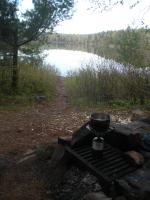
 We set about gathering firewood and making ready for our last nite on the "Isle of Fine Wine White Pines". There were several large white pines on this island. Enough so that we didn't even bother setting up the tarp. And though it was hot out for the duration of our stay, we had ample shade. It was evident that recently some people had chopped of some of the lower branches of these impressive towers. While I'll admit I don't lose sleep over this, it's still sad to see. However, one of these trees gave testament that this is a practice that has been handed down through several generations.
  I doubt seriously that this had happened in my lifetime. There were branches sawed off over 30+ feet up this old tree. [paragraph break]
  As we were sitting around relaxing a thought came to mind. We still had a few beers left that were at room temperature. Instead of trying to sink them in the lake. Which was very shallow here anyways. Why don't we quick run over to Mug lake and grab some ice. So we set out to do just that.[paragraph break] Kelly put his knewly claimed hatchet to a most meritorious use.
  In no time at all we had filled my small collapsible cooler.
  We paddled back to Wine. We let a few of the beers chill while we made and ate our supper.
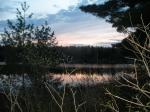
  Nothing quite like an ice cold beer this deep into the wilderness![paragraph break] We polished off the remaining beverages and enjoyed a nice long relaxing campfire on this our last night on "The Isle of Fine Wine White Pines".
 [paragraph break]
[paragraph break] Wine Lake, Mug Lake
We packed up and headed out early. The portage out of Wine to Frederick was considerably tougher going this way. We passed through Frederick and were back on Zenith in no time at all. I don't recall thinking much of Lujenida lake when we passed through the other day. But it sure was a "purdy" site to see today. Seen a huge garter snake on my last trip back. Kinda got my blood pumping again. Had to be pushing 2 feet in length. Not my favorite thing but..... We ran across the first group we had seen since day one. We chatted for awhile with a couple of guys from the Red Wing area who were headed north towards the Gunflint trail. As I mentioned earlier, it appears there is a fork in the Kelso river. Once again we had no problem navigating back to Kelso lake. 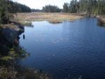
 For the first time during this trip the wind picked up to the point of being a nuisance. We paddled on, the wind actually felt good and acted to cool us down from the heat of the day.[paragraph break] We made it to the landing on Sawbill. Quickly loaded up and went up to Sawbill outfitters to grab some ice, brats and not least of all a hot shower. Feeling refreshed, we headed off to Baker lake campground to spend the evening. [paragraph break]There were some tough portages along the way, but I don't think I've had a trip where the weather had been consistently ideal throughout. (save for approx. 30-45 minutes while it rained) Abundant wildlife & scenery..... What a great trip!!![paragraph break] A special thank you to oneportage,fishnfreak,talusman, & dadof6 for some great on the mark info and advice.[paragraph break] [paragraph break] Wine Lake, Frederick Lake, Zenith Lake, Lujenida Lake, Kelso Lake, Sawbill Lake [paragraph break]