BWCA Entry Point, Route, and Trip Report Blog
June 10 2026
Entry Point 34 - Island River

Number of Permits per Day: 2
Elevation: 1564 feet
Latitude: 47.7912
Longitude: -91.3332
Island River - 34
Perent River portaging
Entry Date:
May 23, 2026
Entry Point:
Isabella Lake
Number of Days:
3
Group Size:
2
I arise early and am greeted by gloomy skies with intermittent rain showers persisting. As I expeditiously finish getting my van loaded up, I am presented with an unexpected dilemma. After placing the Black Pearl atop the racks on my van, I notice some (what appears to be) straw hanging out the back end. Upon further inspection I ascertain that, in the scant couple of weeks since my Bog Lake daytrip, a robin family has constructed its nest there and have already laid and been incubating 4 baby blue eggs. Somewhat reluctantly, I delicately extract the well-crafted nursery and bring it in the house to show Aurora before deciding what to do with it. She is understandably sad, but certainly it can’t be left on the canoe. While we both doubt it will do much good, because we feel the parents will now abandon the eggs, I bring the nest back outside and set it out of the way on the canoe rack very near to where it was and then finish getting things packed. 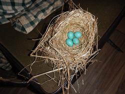
My weather app claims the rain is supposed to stop around 9:00 this morning. As we depart, we do get a few fleeting glimpses of the sun trying to break out, but heavy gray cloud cover dominates the skies as we motor up the Tomahawk Road. After pulling into the Isabella Lake EP parking lot, we encounter a chilling breeze as we begin carrying our gear down to the lake.
Around the mid-point of the trail, I call Aurora’s attention to some cement footings that used to be part of the abandoned town of Forest Center. As we continue portaging, I impart a little about the history of the area to her. She also flashes some ingenuity and takes our ‘lemons’ of wet cool weather and makes lemonade by picking up all the worms on the trail in hopes of using them for bait later on the trip. 
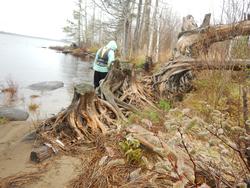
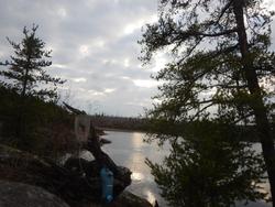
No sooner do we get out on the lake than it starts raining again. Fortunately, there is a campsite only a short paddle east of the landing, and in hopes of briefly waiting out this patch of inclement weather, we pull into the invitingly narrow sandy beached landing and check it out. Of course, the big drawback is that it is literally within a stone's throw of the EP landing. Having said that, I’d still rate it as above average. A few nice mature cedars dominate the shoreline entry, and there is a very neat conglomeration of the extensive remnant root ball of a few other mature specimens who didn’t survive the Pagami Creek fire. Much of the site was burned over but, there are some decent grassy tent pads, and the fire grate is nicely situated, but the log seating could use some upgrading. (Note: there are some ideal, already cut logs lying about camp!) Aurora finds an old gas can on the perimeter of camp and exclaims, “Remember I said I liked to find old stuff out here? We’re not even 5 minutes into the trip and I already found something. This trip is off to a great start! So too, from my perspective, it is very refreshing to see she is eagerly displaying an attitude of gratitude as we begin our adventure! 
As we paddle our way eastward, we are met again with sporadic light gusts of wind & rain showers, but steady progress is ongoing without complaint. As we near the portage into Azure Lake, submerged ‘rockodiles’ are problematic (considering the clouded skies) in our ability to identify them in a timely manner and in their increasing frequency.
Not surprisingly, we’ve seen no one out on the lake nor any occupied campsites as we paddled east across the lake. The parking lot wasn’t full by any means, but there were at least a handful of vehicles there when we pulled in. Coupling that with the fact that there are only a few open/useable sites on the Perent River, we decide to check out site #1921 here on Isabella Lake near the outlet of the Perent River in the event we are forced to backtrack.
I let Aurora hop out away from camp so she can explore the shoreline more closely. Meanwhile I still have an onerous paddle over to the landing as I am still continually scraping and/or bottoming out as I approach. But, once there, the landing is very convenient, and it’s effortless to just step right out.
Pre-trip intel has indicated that this is a very nice campsite, and we both quickly confirm that. Nice view, multiple flat tent pads, lots of room for every purpose. However, some of the luster is lost when we discover that someone recently chopped down a cluster of live trees near the perimeter of camp. And there is a big widow maker snagged up in some branches above one of the many tent pads. Still, neither of us would be too heartbroken to stay here if the need arises.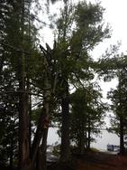
Just before reaching our first portage, we paddle past a trio of stately male mallard ducks lounging on a large boulder where the rapids cascading in from Azure Lake noisily bubble in. The landing here is level granite but is still initially wet and mushy and then sports a few boulders for the first several feet of the portage. The trail then rises just enough to dry out and is an excellent path the entire way before dropping slightly down to a narrow grassy landing on the other end. 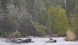
Just south of this portage landing is another campsite. There is a large, exposed boulder out in the water just a few yards from the landing for this site (#1925) serving as something of an identifying marker. The landing here is horrible! I must admit I’m a little biased as, after my foot gets caught, I take a spill trying to get out of the canoe. I go down on one knee & my glasses fall off into the water but, thankfully I am no worse for wear afterwards. 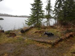
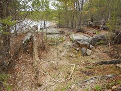
Perhaps this experience jades my evaluation of this site but, after a cursory inspection: constricted, dilapidated fire grate area, no room to store canoe, tent pads way back up the hill etc. Aurora also isn’t too enthralled, and we quickly decide to look for greener pastures. As we exit the narrows just SE of this camp and turn again eastward and enter the fire zone, we soon discover that the next camp (our target site) is occupied. I tell Aurora this is now a moment of reckoning. We can turn back and redo the portage and claim site #1921 on Isabella Lake. Or we can press-on up the Perent River and see if the next site is open. Either way, we’ll have to do a portage of about 20 rods. She doesn’t say as much, but I think the fact that the one up ahead is at the base of some rapids helps sway her mind in that direction.
As we approach the “T” of the Perent River & Powwow Creek, the rain appears to be done for the time being. After making the turn south, the Perent constricts considerably. We pass by (what a friend & co-worker calls Frog Rock) just before reaching the next portage. While the landings of this portage are muddy & mushy, the trail itself is exceedingly flat and, though a bit brushy, easily traversed. Another bonus is that campsite #1913 can be seen from the upstream end of the portage – and it appears to be vacant! 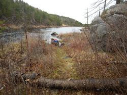
While I’m finishing up the portage, Auroa claims there is a decent sized fish just sitting here at the landing in the water and it’s not afraid of her. She grabs the net and pulls up an injured sucker. Not sure how it ruptured its belly; we snap a couple of photos and eventually release it back from whence it came. 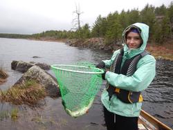
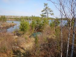
The campsite is indeed unoccupied, and we happily paddle into one of the narrow landings. This is an elevated site with an excellent panoramic view of the widened river we just paddled across. The fire pretty much consumed most of the surrounding area and this site; save for the one large jack pine near the fire grate. There are a couple of ideal grassy tent pads, but they are both right on the trail to the latrine. The rapids running through the gorge just upstream wash out right in front of camp so, we’ll have some natural noise and the promise of good fishing right here. Not claiming this is a 5-star site, but there can’t be even a dozen designated campsites in the BWCA that can claim to have a rapids/waterfall right out the front door, so, it does fall into a very select & rarified class in that sense. I don’t think larger groups would do well here but, for the two of us, it should serve quite nicely. 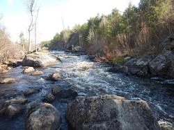
While I’m getting the tent situated, wanting to warm up and dry out, Aurora sets about getting a fire going posthaste. It appears the rain may be done for the day, but it is still overcast and cool, so the fire does help take the edge off our collective feeling of dampness. 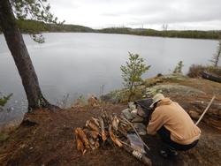
Since it has been a short travel day, after satisfactorily establishing camp, we hope to head out to try some fishing and exploring – not necessarily in that order. Retracing our route in, we paddle up to the confluence with Powwow Creek and continue north up that ever constricting waterway.
Tiny though it has become, we soon paddle upon an impressive increase in floatable water. Of course, we first need to climb over the massive beaver dam holding all that water back. Since this is just an exploratory day trip, it is quite simple for me to just drag the unburdened Black Pearl up the mass conglomeration of slick, wet sticks. 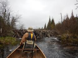
Just a quick paddle later Ferne Creek comes in from the east, and we turn down that already weedy shallow inlet as we also enter the southern boundary of the Fungus Lake PMA (Primitive Management Area). The portage into Ferne Lake is supposed to be located somewhere very near here, and we begin scanning the jungly northern shore for signs of it.
While acknowledging that it's not the portage, Aurora points across the channel to a high escarpment with a huge, very round boulder perched atop the south side that looks like it’s purposely been set up to ambush inattentive canoeists who unwittingly paddle past. Almost simultaneously, we notice a pink ribbon & an old sock tied to a bush here on the north side indicating a very narrow channel leading into what we presume is the landing. 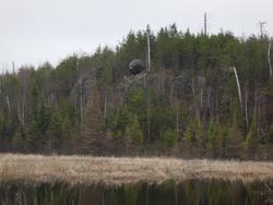
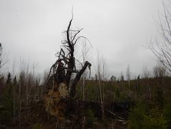
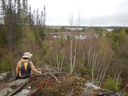
There is very little room for maneuvering, getting out of, or storing the canoe. So, I just pull it up onto shore and leave it there as I can’t imagine anyone else we be along during our exploratory trek. The trail marking pink ribbons continues as we make our way across the trail. It’s very brushy, lots of twists, turns etc. Yet we are able to follow along pretty easily. There are several hills and even a swampy creek crossing. Aurora is amazed by all the moose plums along the way. A couple of enormous burnt-out white pine sentinels have met their demise right alongside the trail, and we have fun crawling on & playing around them. Just before we reach the lake, there is a scenic overlook, and we can see that someone is currently camping on the small island near the landing. Not wanting to infringe upon their solitude, we don’t hike down to the lakeshore and turn back after savoring this idyllic spot for a while. 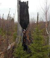
Going back across the trail, Aurora is leading the way and seems to be effortlessly outpacing me. My ever-pondering mind drifts back to memories from not so very long ago; now charred with a poignant fondness, when I would be the one having to wait for her while trekking across long portages such as this. The unerring manner of Father time revealing the inevitable realities of this life give me pause, and I take a moment to thank and praise the Lord for gracing me with these reflective recollections and experiences and this occasion to create more. 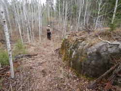
Making our way back to the Perent River, we pull out our fishing rods. I hook into one right away and we linger here for a while before proceeding back to camp. Afterwards, at Frog Rock portage, we are sure to grab a bunch of the chewed-up, dried out beaver sticks (for firewood) that have washed up on shore from the recent high waters. 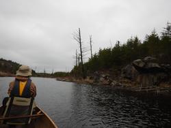
I no sooner get our pork chops on the grill when Aurora catches another fish from camp. A bald eagle and several ducks fly overhead; the beavers are busy right in front of camp, and we even have an otter frolicking nearby. This site is already serving us remarkably well! The sun tries to break through, but the clouds don’t seem like they want to move on tonight, and we are denied a starry sky this evening. Aurora turns in early shortly after we say prayers but, I hang out enjoying the fire, grateful for having had a good day together and for spending some time in canoe-country once again. 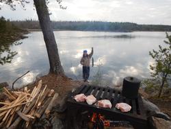
~Isabella Lake, Azure Lake, Boga Lake, Perent River
It’s slightly chilly early this morning but, the clouds have moved off, and the sky is bright baby blue so things should warm up quickly. Ova-Easy scrambled eggs and asiago bagels for breakfast. After, I occupy myself loading Aurora’s pack with our rain gear, 1st aid kit, some finger foods and all our water bottles –filling them to capacity for our extended daytrip up the Perent River. Our game plan today is to just keep plugging away at all the portages and then take our time on the way back to fish and explore the area more thoroughly.
There is a spur trail leading from our camp to the portage through the gorge and, having checked it out already yesterday, Aurora gives me a pithy rundown as we paddle the Black Pearl over to the accommodating landing. Mercifully, there is just enough terra-firma that the trail runs right along the bank of the water for most of its length. Otherwise, it would be a very steep climb up either side of the river to get past this one. As it is, this is an exceedingly flat trail that clearly has been improved at some point (likely by residents of Forest Center back in the mid 1900’s) as the only bothersome aspect is that it is slightly brushy/overgrown. The upstream landing is almost as good as the downstream one. I don’t think a portage of this length could be much easier.
We soon encounter, even what those who may only look at a map will immediately realize, one of the obvious realities of the distinct character of the Perent River. There is not a lot of paddling between most of the portages. Our next portage is on the west side of the river and has a more difficult landing. The path is very flat, very grassy, and very brushy. Not much in the way of mature trees in the near vicinity, and the downstream landing is cumbersome with a sloping rock face on one side. This is one of the longest portages on the river at around (depending on map) 40 rods. 
Some maps show a portage immediately after crossing this tiny ‘bay’ and starting where the river constricts down. While the current here was noticeable, we seen no portage landing/trail nor felt there would be a need for one here under present normal conditions as there were no nearby beaver dams that we ascertained that would dramatically change the flow of water through this narrow channel.
After navigating the channel, the river broadens into an almost lake like setting and the slight breeze is actually kicking up some small waves. There is supposed to be an old campsite in this vicinity, but we see no trace of where it may have been. We’ll investigate more on our way back through.
The rapids ahead indicate we will soon be portaging again. However, we have some difficulty locating the landing as we pull up to what appears to be a landing on the south side but quickly learn otherwise. We ferry across the washout flume to the north side which looks even less promising. I pull up to shore and tell Aurora to hop out and scout around. At the base of the rapids she hollers out, “There’s an old campsite here!” So, I locate a spot to pull off and get out too.
My Voyageur map indicates this site should be at the other end of the rapids but, indeed, there is an old fire grate (that’s still in pretty good shape) here, but the site has apparently been abandoned as most of the immediate area is overgrown. Of concern, is that there is no sign of anything nearby that remotely resembles a portage trail. We pull out some Clif bars and take a break as I try to look closer at my map to determine which side of the river the red portage line is on. It looks like this side....
I walk out of the woods back to the water's edge and tromp and high step through the hummocks and long grass on this (north) side of the river. About 40-50 yards from the spot where the rapids wash out, a clearly visible trail is seen heading up into the woods. Due to all the long grass/hummocks it was very difficult nigh impossible to spot from out on the water but here it is! I figure with all the trouble locating it that it’s going to be a beast of a portage. And while it is slightly more challenging than what we’ve encountered so far, it ends up being a gentle up an over on another excellent (though brushy) path with a beautiful grassy staging area on the upstream end. Once we’re across, I wonder out loud to Aurora, “That grassy area clearly has room for a couple of tents, and that’s where the map says the site was. I bet the campsite ran across the length of the rapids back in the day.” Of what we could see of them, these rapids were a bit pushier than the previous set. And we made note that while the landing was much more visible on this end, it was quite close to the top of the chute.
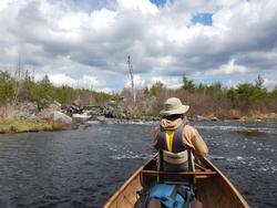
As we paddled away, for the first time, the forest began pulling back from the shoreline of the Perent River replaced by large expanses of swampy marsh. Even though the day was now upon us, we are hopeful to spot a moose in this stretch. While the moose seem to be hunkered down, we do come across an equally surprising sight. As we are approaching a small rapids/beaver dam, the unmistakable sound of a canoe paddle clanging off an aluminum gunwale reverberates across the open expanse. Seconds later a group of 8 men (4 canoes) come paddling around the bend. We exchange pleasantries as we watch them negotiate the tiny flume of rapids before we can pull the Black Pearl up through. I must admit, I did not expect to see anyone on this stretch.
At least when looking at the map, the section we are entering now could be the most confusing as there is another (Tomahawk???) creek coming in, and the river appears to turn back on itself near our next portage. Not to mention, the recent experience on the last portage hasn’t instilled me with a canoe full of confidence either. Happily, however, we have zero difficulty locating the sloping rock faced portage landing here. 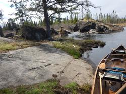
This trail is the brushiest we’ve encountered yet and the hill has a noticeable gradient to it but is nothing close to severe and the trail is short so it’s over before we even work up a sweat. The upstream landing is a bit tricky, but this is a scenic spot to be sure.
The forest has crept back onto the shoreline, and we cross out and then back into the fire zone as the river meanders through several twists & turns. We paddle upon a short, narrow flume we must get out and pull through before the river starts broadening out again as the surrounding hillsides begin to cast a longer shadow as well.
The now familiar cacophony of crashing water begins to echo, forewarning us of another impending portage. The narrow landing is spotted in some thick grass on the north side of the river. There isn’t much room here, but we don’t need much either. It appears this section of this trail has clearly been washed out at some point, as the start is a ravined succession of small rock and boulders. The brushy trail then climbs significantly before leveling out and then drops steeply down to a muddy/grassy upstream landing which is precariously close to the head of the rapids. Certainly, the most challenging portage of the day thus far. But that is tempered by the fact that it is also the most aesthetically pleasing, and we will be lingering here on our way back. 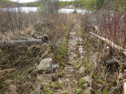
Since this is approximately the mid-point of our travel plans for the day, I thought I’d interject some thoughts and noticed patterns of the experience thus far. I believe all the portages we’ve done (including this last one) have clearly shown signs of being improved and, except for the beginning of this last trail, are all excellent paths with very minimal bothersome boulder, root etc. Impediments. Beyond the various minor gradients, the overgrown/brushy nature being the only real hindrance of note. Frequency is the primary detrimental word that comes to mind when describing the unsavory aspects of these portages.
The river remains wide throughout this next section, and a preponderance of lovely cedar trees seems to be replacing the Jackpine as the predominate shoreline attraction. Our next portage is on the east side of the river. The narrow landing isn’t the greatest, but the trail is a flat pine duffed path for most of its short length. As one might guess, a giant white pine sentinel towers over the downstream end of the portage.
It's a short paddle to the next trail which is located on the south side. A very difficult muddy boulder strewn downstream landing and then one of only 2 portages along the Perent River that ‘boasts’ a significant hill to climb. It is also one of the longest (around 45-50 rods) trails. A wet muddy, mushy landing on the upstream side.
An even shorter paddle to the next portage which is located on the north side of the river. This one mostly traces the banks of the river on a very flat path that has some troubling roots and boulders along the way. There is a nice white pine sentinel about mid trail however, we encounter another similar sized one across the trail too. Fortunately, at least the interfering branches have been cut away. A tight bouldery landing on the upstream side and then the river widens a bit into an idyllic little pool below the next set of rapids. 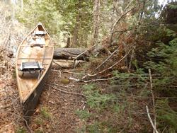
NOTE: We did not do the last 2 portages to Perent Lake on this trip; we stopped at the pool just below the next portage (2nd from Perent Lake) to have lunch and fish. However, we did do those 2 portages a couple years earlier, and I will add my notes from that trip here to complete the documenting of travel on this river.
The 2nd to last portage before Perent Lake is located on the north side of the river. While the landings aren’t horrible, they are not ideal either. It’s a very level trail that has some boulders along the path that can be hard to see due to its overgrown brushy nature. One of the longest stretches of continuous paddling is now encountered before reaching the last portage into Perent Lake. This section will likely be choked with weeds during the summer.
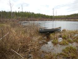
The last portage is also the longest at nearly 60 rods. It is also located on the north side of the river. A mushy downstream landing and another level, though overgrown & brushy, path leads to a nice sandy beach landing on Perent Lake. The rapids here are not severe, and we did see a group walking their canoes through during our visit.
NOW BACK TO THE CURRENT TRIP REPORT: As previously mentioned, we had made it back this far (from the other direction) on an earlier trip. Our group had some decent luck fishing then so, after grabbing some lunch (Zup’s smoked polish & asiago bagels) we wet our lines for the first time. The breeze gently blows us where it will around this quaint lush pool, and Aurora gets us started by catching a small northern.
We slowly start working our way back to camp. We don’t stop to fish after getting across the big hill portage but, the very next one has a scenic pool below the rapids that looks very ‘fishy’ so, we float out to try our luck. Aurora catches a walleye in short order and then another nice one not long after, which she measures with the sticker ruler inside the Black Pearl – 20 inches. She asks. “Should we keep it?” To which I say, "No, I didn’t bring the filet knife, and we’d have to drag it across too many portages before getting it back to camp.” I haphazardly snap a couple of photos before she gently releases it back into the river at which point she confides, “I think that was the biggest walleye I’ve ever caught?!” Aurora has caught countless walleyes over the years but, it just never occurred to me that she hasn’t hooked into a big one yet. If I had realized that was her new personal best, I would’ve taken the time to get a better picture. Ah well, she once again is just grateful for the experience. 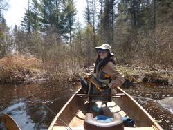
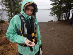
Next up is the other portage with a ‘big’ hill at the bottom of the ‘U’ section of the Perent River. It was hit hard by the fire, so exploration of the gorge and scenic rapids is relatively easy, and we indulge ourselves by doing just that. I hike along the rim of the gorge taking in the sublime scenery eventually hooking up with Aurora near the upstream landing where she has found a new friend. A baby painted turtle who is understandably quite shy and won’t come out of his shell. 
 Back on the river we fish in the big pool below these rapids before proceeding onward. I had been concerned about finding the next portage when we were coming from the other way but had no trouble locating it then. Now, we do get briefly turned around trying to spot it when heading down the river. I do believe this is also the section that straighthairedcurly mentions (in her superb trip report) where she became temporarily disoriented too. There is a spot that does indeed look like a portage landing in the little finger on the west side, near the top of the ‘U’ where there is a rapid running. While it is excruciatingly close to the real trail, and the water running through the rapid eventually leads to where we need to go, this is not it. It also doesn’t look at all familiar, and we soon realize we need to paddle around the previously unnoticed little fishhook bend to get to the actual portage.
We continue exploring and fishing as we paddle & portage our way back to camp. Aurora adds several more smallish walleyes to her tally as the weather pattern now holds to steady sunshine, but the wind is beginning to increase and sustain. 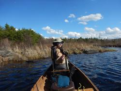
Returning to camp with plenty of daylight yet to burn, I process some additional firewood for this evening. I am grateful to learn that the lone mature Jackpine at this site is well positioned as it provides a generous amount of late afternoon shade. Still itching to fish, Aurora asks if she can take the Black Pearl out solo but, I don’t think it is wise as the wind has picked up and I remind her of what happened to Naomi on our trip last August. Besides, camp is probably the best spot anyways, and she does end up catching a few more from our shore. 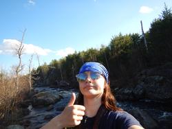
By nightfall the wind has receded, and we are able to enjoy a glorious star lit evening together watching the busy beavers out in front of camp as we both stay up later tonight before retiring to the tent after prayers for a game of rummy as a Nite cap. I won’t say who won. 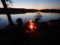
I am up earlier today, and it is already much warmer than it was at this time yesterday. After my morning prayer routine, I boil some water for hot chocolate and grab a bagel before beginning the process of taking camp down. Aurora is still sleeping so I ever so gently nudge her to get her going. She complies, gets up and makes herself a cup of hot chocolate and grabs our last bagel as I finish getting things packed away.
I brought a bottle of tonic water along on this trip. Not that it happens all the time but, over the last several years, I would occasionally have severe leg cramps, especially on cooler nights/morning in the tent. Obviously, that is not close to the ideal locale to try and work them out. So, as a hopefull remedy, I brought the tonic water and would take a gulp or two before going to bed. It certainly seemed to dramatically minimize/prevent the occurrence of my leg muscles tightening up, so I think I’ll be bringing some along on future trips. 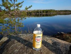
Aurora douses our meager fire, and we set off for Isabella Lake. We make quick work of Frog Rock portage and are soon on Boga Lake where the lily pads are just beginning to emerge above the waterline. As we approach campsite #1926, the familiar aroma of campfire smoke fills the air. We were hoping to check this site out before heading out, but it must still be occupied. Yet, when we paddle past the exposed kitchen area, there is a steady plume of smoke rising from the boxed in fire grate, but we don’t see anyone there. So. We pull into the narrow sandy landing around the point to investigate. 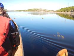
To our amazement there is no one here! As mentioned, it is one of the box fire grates and there is only one large piece of wood there so, it's unlikely to go anywhere. Still, Aurora dumps several cups of water on it to reduce the odds to zero.
We also take some time to see what we missed out on with regards to this site. The fire grate area is exposed but there are several very nice tent pads and a neat huge boulder back by one of them. There are several nice mature trees that survived the Pagami Creek fire, including an impressive shoreline cedar. I think most would concur that this is unquestionably the premier designated campsite along the course of the Perent River. 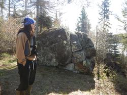
At our next portage, Aurora astounds me. On this trip we have been able to get all our gear across in maybe a little more than a portage and a half. Essentially, one pack and a few loose items are left after our first trek across. Aurora voluntarily grabs the pack and brings it across telling me I just need to grab the chairs. An unexpected heartwarming moment to be sure. 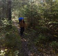
Once we poke out onto Isabella Lake, there are several canoes seen out and about on this gloriously sun-drenched morning. There is a bit of walleye chop to contend with as we work our way back to the entry point landing but, the wind & waves serve as more of a cooling blessing than any sort of hindrance. The landing is a popular place on this beautiful morning as several other groups are exiting, and entering, as we pull in. In contrast to when we entered the other day, today we literally work up a sweat negotiating the portage back up to the parking lot. Soon we are on the Tomahawk Road behind a train of slow-moving vehicles but, still make it home around noon. 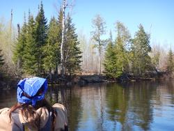
After getting most of our gear unloaded and put away, we still have time to stop at the cemetery to briefly visit Aurora’s Grandfather (my dad) and then Aurora’s cousins before hitting the open road to bring her back to meet her mom.
I thought things went well on this trip. We got to all the places I wanted to get to, had plenty of leisure time for fishing and evening campfires plus there was a good amount of wildlife that presented itself, bugs that didn’t and, for the most part, the weather was nice too. I didn’t find out until a week or so before the entry date that Aurora would be joining me; so, I half expected she would be rolling her eyes and be exacerbatedly asking, “What is Dad getting me into on this trip?” but, she did a fantastic job handling all the portages and it’s always a memorable thing to catch your biggest fish ever. (at least of that species) At least as equally so for the proud papa watching it all happen.
In the final analysis, we crossed all 13 portages on the Perent River (except the last 2 closest to Perent Lake) at least twice on this trip. As the maps indicate, all are relatively short, most in the 20 –30 rod range. Only 2 have sizeable hills, there are also a couple of gentle up and overs, but most are very level with excellent paths. In my estimation, the primary hindrances would be the brushy, overgrown nature of the trails and the typically narrow, bouldery landings on many of them. I looked at the time stamps on the photos and determined that we made it from our campsite (#1913) on the Perent River all the way to portage #668 (the second to last from Perent Lake) and then back to camp, for a daily total of 18 portages, in a little less than 8 hours. And that is with plenty of fishing and exploring stops on the return voyage factored in.
During normal water levels, I think that most of the rapids would only rate about class 2 but, I did note that, because of the fire, there were a lot of downed trees hanging and snagged in most of them; making running them a dangerous gamble. I would warn that in flood waters, many of these portages would quickly get flooded out and make travel through this route very impractical if not outright impossible. The good news is that, regardless of which direction you’re coming from you should be able to tell by the 2nd portage (on either end of the river) if the trail is flooded out or not. If so, I wouldn’t recommend proceeding.
This was a trip I’d been hoping to do for quite some time as I had often wondered what the mid-section of the Perent River was actually like. Maybe I wasn’t looking in the right places? But there seems to be very little information/photos out there about it, so as always, it was particularly satisfying to be able to see it all firsthand. As I am wont to do, I wrote up this trip report in hopes of sharing a little about the area. It is one of the guiding spiritual principles I try to live out in all aspects of my life: People should see/understand things in a more beautiful/profound way because of me. My great hope is that this report can help do that, at least in some small way, for others who may come after me. 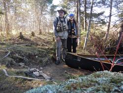
And to tie up a loose end from the beginning of this trip report. I am happy to report that the robins reclaimed their relocated home and are currently the proud parents of 4 perpetually hungry babies.
As always, in all things: Praise be to the Creator Jesus Christ, my Lord & King!