BWCA Entry Point, Route, and Trip Report Blog
July 12 2025
Entry Point 20 - Angleworm Lake
Angleworm Lake entry point allows overnight paddle only. This entry point is supported by Kawishiwi Ranger Station near the city of Ely, MN. The distance from ranger station to entry point is 18 miles. Access is a 640-rod portage to Angleworm Lake.
Number of Permits per Day: 2
Elevation: 1260 feet
Latitude: 48.0659
Longitude: -91.9303
Angleworm Lake - 20
Number of Permits per Day: 2
Elevation: 1260 feet
Latitude: 48.0659
Longitude: -91.9303
Angleworm Lake - 20
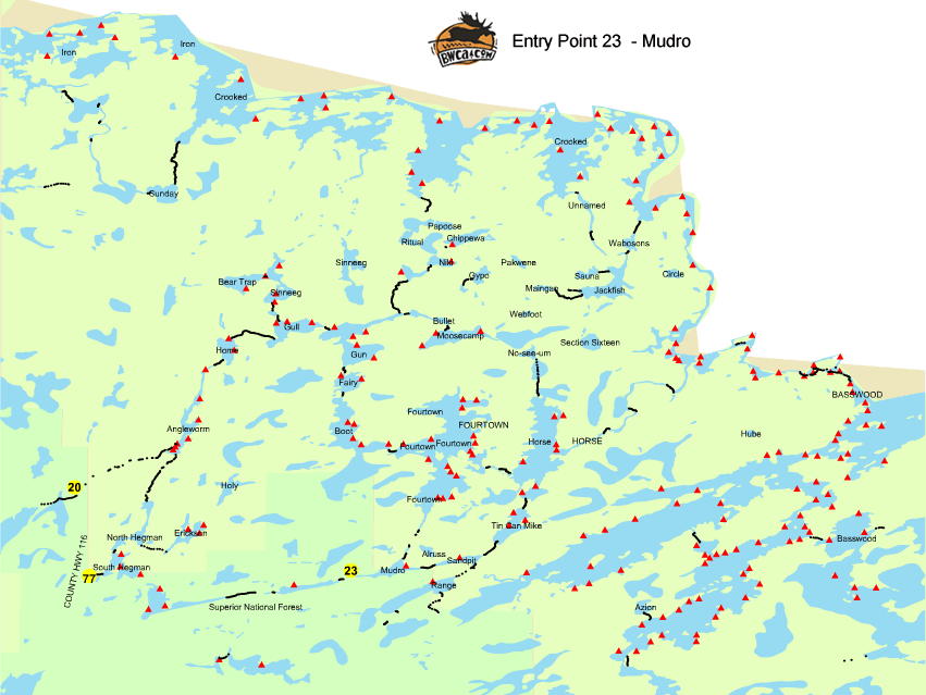
mudro
by luv2pack
Trip Report
Entry Date:
June 07, 2008
Entry Point:
Mudro Lake (restricted--no camping on Horse Lake)
Number of Days:
5
Group Size:
6
Trip Introduction:
My husband and I took our first BWCA trip last year through this same entry point. My parents have never done this sort of thing and wanted to try it, so we chose the same entry point since we kinda knew our way around here.
Day 1 of 5
Saturday, June 07, 2008 It's 4:00 in the afternoon by the time we finally arrive in Ely. We have decided to make a short stop to the North American Bear Center before continuing on to the outfitters. My parents have decided to join us this year and we thought they might enjoy this stop. Then, off to Voyageur North. Once again John and Lynn and their crew did a wonderful job of helping us get ready for our trip! We decided to stay in one of their bunkhouses this year which was very convenient. After getting everything settled and ready for our morning departure we headed downtown to visit a few shops then enjoyed a wonderful dinner at the Ely Steakhouse.
Day 2 of 5
Sunday, June 08, 2008 I was the first one up this morning at 4:15. After a quick shower I ran over to the gas station next door to pick up some doughnuts and juice for breakfast, and a Pepsi for myself - an addiction that will be greatly missed this week. Back at the bunkhouse everyone is beginning to wake up. Ross and my dad head over to the station on a coffee run and to pick up some medicine for Tyler, who has woken up with a bad cold. I bring the van around and begin loading up when Ross discovers his wallet is missing. WOW - what a great start! We inform Lynn of the missing wallet in case it is found while we are gone and head out. We finally arrive at our entry point and have the paddles in the water by 7:30. We were able to skip the short portage into Mudro from the parking lot due to high water. Ross lost his footing on a slippery rock on the first of the three portages between Mudro and Fourtown and sprained his ankle, just not a great day for him! We exchanged hellos with the few people we met along the way, and saw only two campsites in use of those we passed on Fourtown. We stopped for a quick snack at the Fourtown to Boot portage, then we were on our way again. Passing through Boot Lake we noticed that all the campsites were empty. We are hoping to get the nice, eastern campsite on Fairy since we have seen so few people. I attempt to portage my first canoe from Boot to Fairy, and did a pretty good job (for a girl). I can't pick the canoe up, so Ross picks it up and places it on my shoulders and away I go. We all load up our canoes and take off for 'our' site to find that someone has beaten us to it, so we head across to the other site. It is 12:30. We spend the rest of the day fishing and relaxing. Made pizza for lunch and had some fresh fish and pasta salad for dinner. Weather has been perfect and it has been a good first day...besides the missing wallet and sprained ankle! 

Day 3 of 5
Monday, June 09, 2008 Ross and I were the first awake this morning, followed by the boys and my parents. Did a little fishing and a breakfast of biscuits and gravy, bacon and oatmeal, coffee and hot chocolate. We packed up and were gone by 10:00 and paddled through Gun and Gull, into Mudhole and then to Thunder Lake. Only saw one occupied site along the way, on Gull. I portaged the canoe again between Mudhole and Thunder so Ross could give his ankle a rest. I think I picked the muddiest one to do...lots of fun. We found a nice campsite on Thunder Lake with plenty of room. Our original plan was to go to Beartrap, but my dads back has been bothering him (back surgery last year) and Ross' ankle was hurting. Ross and my parents went out fishing while the boys played around camp and I made lunch, velveeta shells, mini beef sticks and vanilla pudding. Made a nice fire this evening and put up our new tarp. Good day to try it out as it rained on and off the rest of the evening. A full rainbow appeared between rain showers. A quick dinner of PB&J rolls, then off to bed. 

Day 6 of 5
Tuesday, June 10, 2008 Ross and I were the first up once again. Wonderful day - rain, rain, rain...and cold. After my parents woke up, the four of us sat under the tarp to enjoy some coffee and hot chocolate and watched it rain. We could hear the boys playing in the tent and they yelled out that they weren't coming out 'til the rain stopped. Probably a good thing as Tylers cold has gotten worse. So we gathered whatever dry wood we could find and started a fire to help keep us warm. It stopped raining long enough for the boys to come out of hiding and have some breakfast. We spent most of the day fishing, drying under the tarp or warming by the fire. Ross and I took Kaleb with us to Beartrap Lake (not a person there) and Tyler went with Grandma and Grandpa for some more fishing. We all met up for a dinner of fish and some soup and cache bread. It finally stopped raining, so my dad headed off with the boys to explore a nearby island and just paddle around the lake a bit. We've decided to break camp early tomorrow as there are more storms on the way. We all packed up what we could and had a little snack before heading off to our tents for the night. Cold one tonight - forecast is calling for 33-35 degrees with more rain. 

Day 8 of 5
Wednesday, June 11, 2008 Tyler was up most of the night with a horrible sounding cough. I'm beginning to worry about him. He is getting sicker and the medicine isn't helping. We are all up and have things packed in no time. It is cold, but the rain has stopped so we all relax over breakfast of bacon and some trail mix and hot drinks and are on the water around 7:30. Paddling through Mudhole, Gull, Gun, Fairy and Boot Lakes before stopping for a rest and small snack once again on the Boot to Fourtown portage. The wind has begun to pick up and we decide to try for the island site at the southern part of Fourtown. The weather forecast is calling for 40 mph winds and thunderstorms, and with Tyler being sick, we decide this would be a nice site, close enough to leave in a hurry if needed. We get to the site to find it occupied and decide to go on to Mudro. We figure maybe the one site there would be open, but no luck. Tyler is exhausted and not feeling well, and none of us want to search on for another site so we make the short trip back to the parking lot. Bad weather and a sick kid...time to go home! We get everything packed into the van by 4:00 and head back to Ely and Voyageur North to find that Lynn had put an announcement over the radio to help find Ross' wallet. Talk about going the extra mile...what a dear! We stop at the grocery store to refill on medication and roll into the Grand Ely Lodge for an evening of good food and relaxation in the pool and hot tub. Always enjoyable after a trip to the BW! 

discuss this trip report (8 comments) - last post on June 22, 2022