BWCA Entry Point, Route, and Trip Report Blog
July 05 2025
Entry Point 52 - Brant Lake

Number of Permits per Day: 4
Elevation: 1500 feet
Latitude: 48.0692
Longitude: -90.8455
Brant to Tuscarora via Little Sag Route:
Round
Brant
Bat - Mud
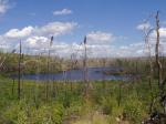
Gillis - burn area is evident:
French
Peter - first lake trout:

Virgin
Little Sag - green trees again!
Mora - gorgeous divide of burn and green
Crooked
Owl
Tuscarora - second lake trout!
Missing Link - with lighter food pack, the portage is OK
Round
September 2015 solo
Entry Date:
September 08, 2015
Entry Point:
Brant Lake
Exit Point:
Missing Link Lake (51)
Number of Days:
5
Group Size:
1

Of course there was a stiff wind coming out of the south on Round Lake so I headed for the west shore and worked my way down to the West Round portage. It had been about 5 years since I last took this and the beavers have rearranged it. First couple portages I was sluggish from long drive and late start. I eventually got to Brant and decided to take the middle campsite about 4:30. I wanted to get further, maybe Bingshick, but I decided that may get too late in the day. The wind was pretty brisk coming down that west arm, but died down nice at night. This is kind of unique site with 3 benches, one down by water, one part way up with cooking area, one on top with tent pads. Little tough to walk around in but has nice views. 


It was an uneventful evening and I quickly discovered that while I enjoy paddling and portaging solo, I hate camp time by my self. Thank goodness for the visiting squirrel. I also had a couple of grouse come down off the ridge through camp and fly across the channel.....must be a travel route.
I went to bed early so I was up early. Saw a nice sunrise, had breakfast of pancakes and bacon and was packed and ready to go fairly early. 


The plan for the day was to head west, then north, paddle the Chub river, and see where I was come supper time. The portage to Gotter looked different than in 2010. I didn't recall it being up on the ridge, but staying low near the water. It had some good hill climbs but some nice views also. I did recall the landing area at Gotter. 


Gotter is more of a swamp than a lake, but I'm a duck hunter at heart and love swamps. I headed west and found the long channel that headed for the portage to Flying. I could see where people were stopping short along the north side to start portaging, but I kept paddling west to see if I could shorten the portage up some. The channel lead me right to a nice landing with a short portage, and down the steps to Flying Lake. 


Just after leaving the landing on Flying, I met my first people...a young couple that asked, "where do those steps go that you just came down?" I said, "that's your portage....and make sure to take the first quick right at the top to make it shorter." He had a new Sanborn paddle that I asked to hoist and stick in the water. Nice paddles. I headed up Flying and decided to skip all the short portages around Bingshick and instead take the 90 rod to Fay to get to the Chub River. I was slightly confused by the landing on the Fay side that looks like a marshy river, but soon found out it's just a little finger off the main lake. I partly paddle and partly push mud to work my way out to the lake. 
When I hit the main lake, the wind was already howling down Fay with some nasty whitecaps. I fought my way up the west bank until I got over half way and then the wind and waves lessened. A rocky portage lead to the Chub River. 

I was really looking forward to a nice little paddle up the Chub River in the Fall but the west wind was really flying down the valley and made it into a wind tunnel. It was a real battle paddling up through Warclub, more River and Seahorse. 

Seahorse was a nice little relief from the wind and I found the portage to French. A nice little downhill trail with a waterfall alongside. French was tossing pretty good in the wind, so I eased along the north shore to check the campsite. It's in the burn and is just grass and 2 small trees. I looked out across the whitecaps on French, then looked back at the forlorn site, and decided to head for the southern site. I paddled back west along the north shore and then headed south and ferried my way across the main north part of the lake and eventually got out of the wind behind the big point, then followed the north shore around until I came to the campsite. It was only 3 or 4 o'clock, but I had had it with the wind, so I made camp. This is a decent little site but has an awful canoe landing. I made camp quick and with the remaining day, I walked around and took pictures of mushrooms. They were EVERYWHERE!....it was almost kind of eerie. All colors, shapes and sizes. I don't know my fall mushrooms, so feel free to fill in some names for me. 


After the mushroom marathon, I lounged around camp. I did notice 4 canoes off in the distance headed for the Gillis portage, chopped a little wood and ate supper. 


I had a small fire that night but still went to bed early after fighting the wind all day. The wind died off that night and it got clear and cold. I later found out that there was a good northern lights display, and I had a perfect camp for viewing them, but I was asleep early and slept straight through til sunrise......OOOPS! I was up early again to see sunrise, eat and pack. The portage to Fern is just a short paddle from this camp. 


Big plans today. I'm headed to Tuscarora, but I'm going to go in through the back door via some PMA travel. The plan is to go through Fern, Gillis, Crooked and then drop down through Jerry and see if I can get through the creeks and the little PMA lakes of Garret and Matthew and come into Tuscarora from the big southern bay. I have no info but it's not real far through the PMA and I have some satellite images. I make the short paddle over to the landing and portage down to Fern. 
I paddle down Fern with a slight tailwind....finally!....portage into Gillis and head for the Crooked portage. I've been on these portages before except the Crooked portage and I've heard it's a neat portage. 

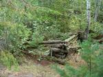
It turns out to be a neat portage complete with a small rapids on the Crooked end, the remnants of an old cabin and old rock, crib docks. 


It's a short quiet paddle across Crooked and I find the shallow little channel into Jerry. There are some scuff marks on the rocks, so someone else has come this way sometime. I look for the campsite on the west shore and don't see any sign of it so I keep paddling down Jerry It's a pretty little paddle and I eventually reach the start of the arm that heads east. There is a beaver dam to cross and a big shelf rock that I eat lunch on before the adventure through the PMA begins. 
It's a quiet little paddle down the east arm of Jerry and the mouth of the creek is obvious but surrounded by a tangle of Alders. It takes a while to crash the canoe through the thicket before it opens up on the other side. I was hoping there would be some flat ground on either side of these creeks with some grass and sweetgale, but instead this one has steep, heavily wooded sides and it looks like the further it goes east, the more it becomes a small gorge. Thankfully, there is only a couple of inches of water in the creek and the footing is good, so I can portage fairly easily right up the creek bed. There are a few down trees here and there, but nothing that alters the route too bad. I take the canoe and food barrel across first, then go back for the gear pack. It takes about 30 minutes to do this first portage to Garret and I'm feeling pretty good about this little bushwack. Things would change...... 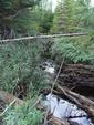

After paddling through Garret, the next creek is again obvious and has a grassy area at the start. Once again I portage right up the stream bed but this gorge is deeper and there are more down trees that must be detoured around. There is a grassy area mid-portage that is a fairly nice walk, but it is brief. I reach Matthew and am still feeling pretty good about myself. 
On the east end of Matthew there is a small series of beaver channels that have enough water to paddle and allow me avoid portaging through the tall grass and mud. There is a small crash through the woods at first because the creek is blocked with boulders and down trees but eventually I'm back in the creek bed again. This creek lies in the deepest gorge of all with walls 30 to 50 feet tall. There is an "S" turn section with huge boulders and some steep drops that requires a detour up through the woods. Thank goodness the woods is thinner here and I find a good by-pass to get around this section. I eventually come to an opening with a bog. The satellite views looked like these water channels through the bog might be paddle worthy......this was a bad assumption. 
I paddle about 20 feet and then hit 3 inches of water and 3 foot of mud. I'm able to reach a log and make it to the far bank. From there, I can cut the corner but it will require portaging through those ankle busting grass humps. I stumble across a moose wallow or scrape while in there so I keep my eyes open. Eventually the grass leads to a wider, flatter creek bed and the last part of the portage is rather quite pleasant and I get to a beaver dam with paddle worthy water on the other side!! There is good creek water from here to Tuscarora, but there are also about 4 beaver dams to pull over....one is a huge monstrosity. I finally cross the last dam and am paddling in Tuscarora. This little adventure started at the beaver dam on Jerry Lake at 11:00 and it is now 3:20. 

Paddling out of the south bay, I check the one campsite out. It's ok, but it's early so I head out around the point to the west to check the next one. It's a winner with a nice little beach landing and some nice tent pads back in the woods out of the wind which has grown quite brisk again and feels a little raw. I'm pretty tapped out so I filter some water, rehydrate and munch on trail mix for a while before setting camp. I eat supper late after snacking so much when I got to camp. This gave me time to walk to the west end of the camp to keep an eye on sunset to see if there would be any photo ops. There was a gorgeous big sitting rock but you couldn't stay there long because the wind was strong and cold. 
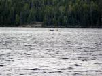
I could see a tarp or two around the lake and one canoe out fighting the wind, but my only real company was very persistent chipmunk who was not bashful about trying to snag a treat. I braved the wind at sunset for a few photos but it never let up at sundown and blew hard all night long. 


It rained a little sometime in the night but the wind had the tent all dry by morning. Mr. Chippy joined me again for breakfast and then I packed up and headed NE for the portage to Howl. The sun and clouds were fighting and the wind was still blowing as I headed north and then ferried NE and wound up hitting the portage landing which has a nice little beach to mark it.


I took my fleece off and prepared for a walk in the less windy woods. The portage to Howl is a nice rolling trail through some gorgeous woods. The Howl Swamp is about a 40 yard paddle across a deep slough that the beavers maintain. 


After crossing the swamp, you reload and portage again to Hubbub Lake. There was another rock crib dock at Hubbub, and after a short paddle up the lake, I discovered one at the far end also. 


I make the portage over to Copper and find a very quiet, pretty little lake. I originally had plans to maybe go down to Sora Lake and do some more PMA exploring, but I opt to just do some relaxing paddling instead. Part way down the lake there is a small, somewhat out of place rock slide. Just before I make the turn to head up the NE arm, I spy a nice flat rock along the shore that looks like a good lunch break spot. 


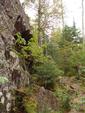
After lunch, it's a brief paddle up the NE arm of Copper to the portage landing. The beavers have made it a little confusing, but I eventually get on the right trail and make my way over to Snipe. I camped on Snipe a few years ago and really liked it's rock formations. I stop and take some pics of some spots I remember. Rocky channels, moss and lichens, and a flat rock that looks like a map of Wisconsin....lol.


Original plans were to camp on Snipe, but it's early so I press on for Missing Link. I recall the portage from Snipe to Missing Link and I'd just as soon get that bugger behind me while my joints are warmed up. A grouse runs down the trail ahead of me just before I crawl through the deep crevice near the Missing Link end. It must be 6-7 feet deep and you have to shove your canoe off your head up onto the top ledge and then crawl up after it. I'm hoping this entry point lake isn't full making me portage back to Snipe for my last night. There are only 3 campsites. When I return with my pack, I see a canoe on the lake and I get a little worried. I paddle out and around the corner and the far north site is empty. I ate lunch here years ago and recall it as just an ok site. It will do for my last night. 


I eat early and then take a paddle around the whole lake seeing as how the wind has laid down and the water is calm. There is a group of 4 guys at the middle site that I say hi to......first people I've talked to in 5 days. It gets cool, so I make a small friendly fire for the night but again go to bed fairly early. I only have one portage and a short paddle left for the morning. 
Something rousts me awake at 4:30am. It sounds like a bull moose roaring in the grassy bay about 60 yards north of my tent. I roll over to hear better and listen to see which path he is taking. I don't worry about them too much but the rut may be starting soon so I don't need him on top of my tent. I hear him splash and crunch brush around the north end of the lake and breathe a sigh of relief. It's very cool and damp and a quick peek outside reveals pea soup fog. I can't get back to sleep and toss and turn til 6am and then finally get up. After a slow breakfast, there are some foggy photo ops. 


The fog is slow to lift but I'm in no hurry as I organize gear. The sun and breeze eventually come out so I put up a clothes line and dry my tent out. Finally, it's time to leave so I pack up and make the short paddle over to the Missing Link portage. This portage doesn't have much for elevation changes (gradual downhill to Round) but is still a very under-rated portage for nastiness. About where the official BW sign is, a resident squirrel scampers up a tree and bids me farewell. 

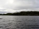
I paddle a little ways out into Round Lake.....to the west I can see my entry portage to Brant....behind me is my exit portage from Missing Link....ahead of me is Tuscarora Lodge, a warm shower, and a bunk for the night. I tip my hat and say goodbye to Canoe Country for another season.
It's been a good trip: no mishaps, good weather except for some pretty windy days, nice cool temps, some new lakes visited. One final "beach landing" picture to mark the end of this adventure. 
After a much needed shower, I head up to Trails End Cafe for a grilled cheese and fries. Coming back to Tusc, a cub bear crosses the road right by the Cross Bay landing. After having a nice chat with Andy at Tusc he asks if the sow was there too. I said no and he tells me where they hang out so I hop back in the truck to go look. I don't have to drive far to find them. 


I lounge around Tusc all afternoon....sit by the beach and sip a beer.....just recharging my batteries. At supper time, I of course hit the Trail Center and have an enjoyable supper with Maxx (Bill), Diana his wife, and Mocha. Back to Tusc to my bunk and on the road early in the morning.

