BWCA Entry Point, Route, and Trip Report Blog
May 03 2024
Entry Point 52 - Brant Lake

Brant Lake entry point allows overnight paddle only. This entry point is supported by Gunflint Ranger Station near the city of Grand Marais, MN. The distance from ranger station to entry point is 45 miles. Access is a canoe landing at Round Lake with an 85- and a 35-rod portage to Brant Lake. This area was affected by blowdown in 1999.
Number of Permits per Day: 4
Elevation: 1500 feet
Latitude: 48.0692
Longitude: -90.8455
Brant to Tuscarora via Little Sag Route:
Round
Brant
Bat - Mud
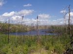
Gillis - burn area is evident:
French
Peter - first lake trout:

Virgin
Little Sag - green trees again!
Mora - gorgeous divide of burn and green
Crooked
Owl
Tuscarora - second lake trout!
Missing Link - with lighter food pack, the portage is OK
Round
Number of Permits per Day: 4
Elevation: 1500 feet
Latitude: 48.0692
Longitude: -90.8455
Brant to Tuscarora via Little Sag Route:
Round
Brant
Bat - Mud
Gillis - burn area is evident:
French
Peter - first lake trout:
Virgin
Little Sag - green trees again!
Mora - gorgeous divide of burn and green
Crooked
Owl
Tuscarora - second lake trout!
Missing Link - with lighter food pack, the portage is OK
Round
BWCA August 2013
by BEPCO
Trip Report
Entry Date:
August 05, 2013
Entry Point:
Saganaga Lake
Number of Days:
6
Group Size:
4
Trip Introduction:
Since we had our own canoes and kayaks, we used our outfitter to tow us to our camp site and pick us up 5 days later. This turned out very well, since we are getting older and did not have to deal with the 3 hour paddle each way.
Report


discuss this trip report (3 comments) - last post on August 14, 2013