BWCA Entry Point, Route, and Trip Report Blog
May 31 2026
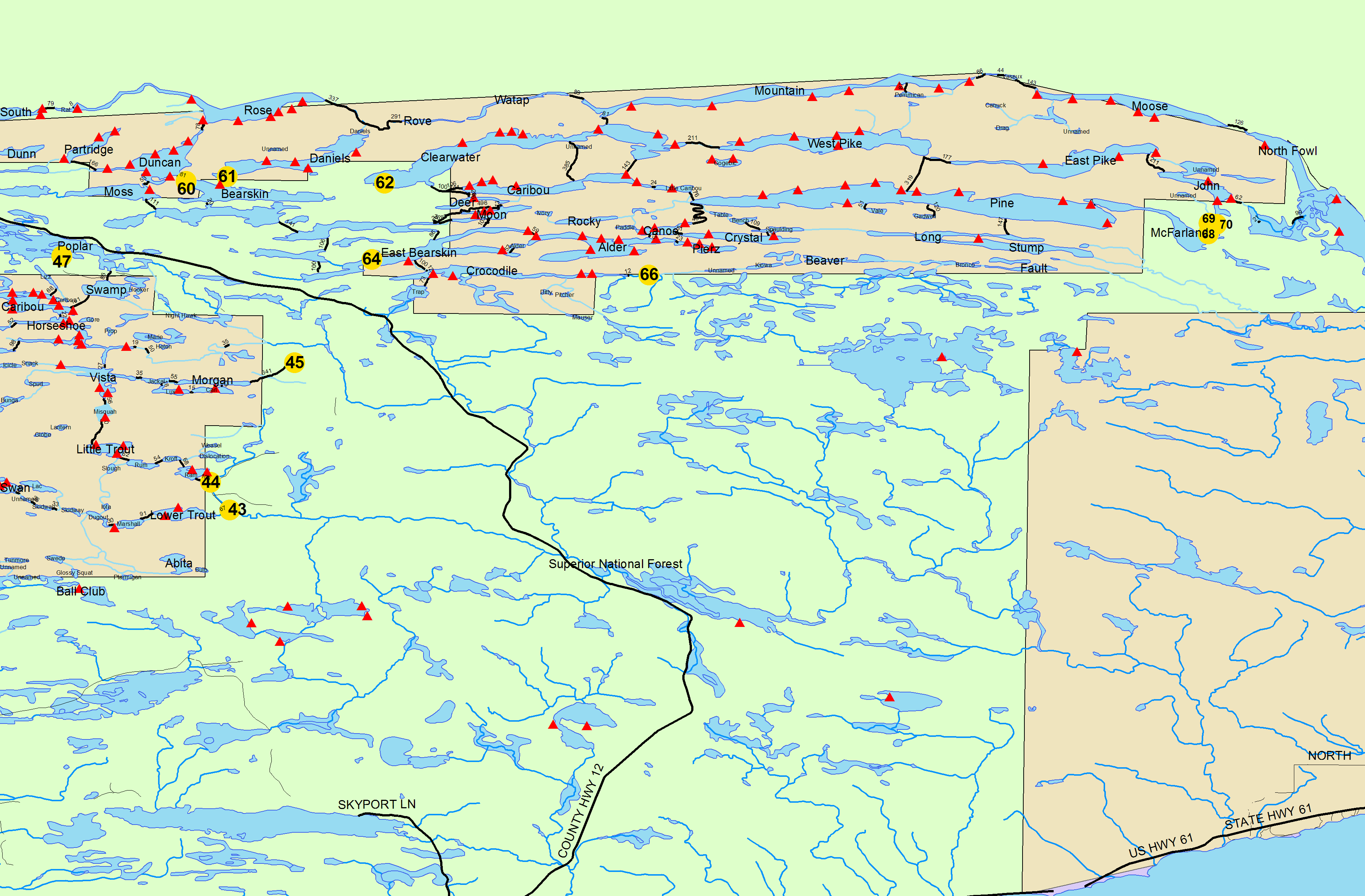
Entry Point 70 - North Fowl Lake *
Number of Permits per Day: 2
Elevation: 1256 feet
Latitude: 48.0543
Longitude: -90.0540
North Fowl Lake * - 70
Tip of the Arrowhead
Entry Date:
October 19, 2023
Entry Point:
John Lake
Number of Days:
4
Group Size:
2

Stopping in Grand Marais, we grab some last second supplies and a Subway sandwich for lunch before proceeding onwards. Upon arriving in “downtown” Hovland, immediately after crossing the Flute Reed River, we turn left up the Arrowhead Trail. The rain has let up a bit from earlier this morning but still spits out an occasional short shower. While the gravel road is in excellent condition, its saturated nature quickly transforms my silver van into a mud-caked mess.

Just past and across the road from the McFarland Lake campground and boat landing, I back down to the small yet adequate dock that serves as the official John Lake entry point #69 landing. Donning our boots & raingear, we expeditiously get our packs transferred into the Black Pearl, which is precariously clinging to the gently sloping gravel landing. Doing a trip this late in the canoeing season, there are 3 weather related factors I’m considering for determining the viability of this trip. Projected temperature, rain & wind. If 2 of these surpass the threshold of what I consider extreme, I'll pull the pin on the trip - especially with Aurora along. As it stands, the temps are going to be cool, but the overnight lows are still supposed to only be in the low 40’s which isn’t too severe. It is currently raining and there is a good possibility that it will do so on & off throughout our stay so that is a definite concern. So, the final fact that there is little to no wind, nor are any high winds predicted for our stay, convinces me that we shouldn't have any major problems. Still, we’re not going in too far and I instruct Aurora (were something to happen to me) that if all else fails she’ll also be able to get back to the van using the Border Route Trail.


The recent lack of below freezing temps & high winds have allowed the brilliance of these fall colors a longer branch life than what typically might be expected. Even in the less-than-ideal conditions as we depart, the warm glow of some nearby golden tamaracks and yellow birch leaves serve to effectively assuage the chill of our cool countenance.
It isn’t shown on my Voyageur map, but we soon encounter a short portage between Little John & John lakes. Truth be told, it’s just a small beaver dam that is easily pulled over, but for those who may be more conscientious about their canoe bottoms, there is a short little used trail on the west side of the channel – just look for the NO SNOWMOBILES sign. I silently muse to myself; the resident beavers must work for the Forest Service because this dam is literally right at the wilderness boundary.

Shortly after negotiating this tiny obstacle, we paddle past a lone canoe with 3 ladies whose cheerful dispositions bely the current weather conditions and brighten our outlook as well. Just after emerging out of the short, small channel into John Lake, where there is a vacant site on the eastern side, we can see that the site near the entrance to the Royal River is currently occupied. There are a couple of impressive stands of golden tamaracks along the lakeshore, but since it’s still raining, I neglect to dig my camera out. Pulling into the last site on the lake to rest up for the portage into East Pike as we watch the 6 trumpeter swans across the lake near the wild rice beds. Aurora is already hoping to claim a camp, but I’d like to get a little further in, so I eventually prod her to continue.
At the portage, a very shallow water landing with a mess of boulders onshore greets us near a stand of wild rice. A general topographical reality of the BWCA is that the further east you travel the more consistently rugged the terrain – most especially when portaging north/south. Well, we’re about as far east as you can be and planning to head north so, with that harbinger of peril hanging over our heads we start off.

There is a noticeable short climb right off the bat but very quickly seems to level off. (Pay close attention to that word “seems”!) Much to my surprise the trail is in very good shape, not overgrown and we don’t encounter any big, steep climbs. However, while the incline is not overly noticeable, it is a slow steady grind as elevation is continually gained. Near what I presume is the crest is a welcome opening that appears to function as a fashionable “pose” area, and we endeavor to use it for that purpose as well.
Back on the trail, the path noticeably rolls for a distance before dropping steeply down to a short board walk through some thimbleberry plants. After a quick though not as long or severe climb back up, the trail levels off and widens out the remainder of the way to East Pike. After being the first to complete the portage, Aurora excitedly runs back to give me the intel on the lake & massive landing area.

While the landing itself isn’t overly huge, there is a locale just up from the lake that is undoubtedly a staging area par excellance! It looks like this may have been a resort at one time and Aurora quips, “we could just camp here!” As much as I’d like to be done traveling for the day, we eventually shove off back into East Pike to claim our home for the next few days; hopefully at one of the designated sites. Aurora lounges in relative comfort as I head back for our last load.

Even though daylight hours are in limited supply, we paddle over to the campsite just east of the landing to check it out. The landing right in front of camp is rocky, steep & treacherous – especially in cold water. However, we’re able to scramble up to the elevated fire grate area without incident and promptly notice a few nice tent pads just behind. There is a huge old growth white pine towering over the center of camp and there are some other impressively large trees in the immediate area as well. Eventually we happen upon a very constricting, but much more accommodating, landing just a little east of the main camp area. While this is an above average site, I’m hoping to claim the next site (west) down the lake.

After leaving and proceeding on, we gather the optimal pieces of sunbaked firewood we see fortuitously laying upon the shoreline. Light rain persists as we pull into an elongated sloped rock landing at our target site. While the landing itself is respectable, the steep climb up takes a little fancy footwork as there are a finite number of good footholds and the wet rock faces are slippery. This proves to be of more importance when coming back down. There is an expansive garage area for the Black Pearl that would accommodate several canoes. The log seating isn’t spectacular but is adequate. There are multiple level pine duffed tent pads and a myriad of mature pine & cedar trees allowing for multiple top-notch tarp & hammock options. The trees really shelter the main camp area nicely but do constrict the view. However, there are several excellent spots to perch oneself on the sloping rock face that provide panoramic views in all directions.
The first order of business is to get our CCS tarp rigged up; which we’re able to do very near the fire grate – which is beneficial since it’s still raining. Next, I get a fire going so Aurora can warm up a bit and keep the fire going. Since we brought a few handfuls of dry cedar kindling (a co-worker's husband donates these quite frequently), a one match fire is easily accomplished even in these exceptionally damp conditions. After getting our gravity water filter situated and the tent & sleep systems set up, I can finally turn my attention to supper.
Aurora has done a great job keeping the fire going, so we now have a good base of glowing crimson cooking coals to grill our steaks. Mercifully, the rain lets off as we begin to prepare supper. The sun sets shortly after 6:00 so we end up eating under the illumination of our Luci light.

After the dishes are done, I process some more of the firewood, so we have an ample supply for tomorrow. It’s early bedtime as we retreat to the sanctuary of the tent. I still haven’t changed out of my damp socks so, that is the first order of business before settling in to play a few games of cards together. While I am a big fan of the Luci light, I also usually insist on bringing a propane lantern – especially on shoulder season trips. One reason is that on fall trips there simply isn’t as much daylight to properly recharge the Luci. But, more importantly, it also serves as an effective heating implement inside of a closed tent. Which really pays big dividends on a day like today. You just need to take extreme caution not to allow the sides of the tent to touch the globe. We bask in comfortable warmth as we sit up playing cards and reviewing the day's journey, while looking forward to what adventures tomorrow might bring.
After getting up this morning, I fire the lantern up again, so it warms up the tent interior while Aurora sleeps in. Much to my surprise and jubilation, it appears that most of the clouds have moved off this morning. Although, there is still a heavy mist lingering on sections of the lake. It looks like we’ll have a sunny afternoon!

After scrambled eggs & bagels for breakfast, we prepare to head out and take full advantage of the glorious weather God has graced us with. Our hopeful destination today is Gadwall Lake and, then tomorrow, Gogebic.
There is nary a trace of wind so, after initially sticking close to shore, I venture out on the lake a bit to get out past the long shadows from the high ridgeline and take full advantage of the luxurious radiant early morning sunlight. True confession: I am smitten with East Pike Lake! While I believe it would be a spectacularly stunning body of water in any season, the kaleidoscope of the brightly illuminated autumnal hues that presently paint the high hillsides in every direction make this windless paddle almost seem like something of a dreamscape. It’s been a very peculiar, elongated fall season. Some trees are completely denuded, while others are still mostly green. Yet, I don’t believe we could’ve hit much closer to the peak than we have here today. And these current facts of nature really help East Pike shine all the more.

My Voyageur map doesn’t show any islands on East Pike (nor did I note any on other maps either) but here near mid-lake, just off the northern shore, is a decent sized island. There is supposed to be another campsite along the northern shore but, according to my calculations, there’s no way we’ve paddled far enough to reach it. Yet on the mainland shore, just past this island, there appears to be a picture-perfect canoe landing on a small peninsula. Aurora quickly hops out and gives it a cursory look see. My estimations prove correct, this is not the designated campsite, but it certainly would serve well as one. And finding some sawed & burnt firewood clearly indicates that others may have attempted to use this spot for that purpose. I inform Aurora, that since it is after permit season (September 30th) that we/or anyone can camp anywhere we’d like. However, we are NOT moving camp today!

After lingering for a while, we paddle on and come across the other officially designated site. It has a rocky, shallow water landing with about a 2-foot ledge up out of the lake to negotiate. This may prove a little trickier in high water but, it’s convenient for us here today. There is a large, flat, pine duffed area with multiple tent pads and several large trees in & near the fire grate area which has excellent, planed flat log seating. The view from camp is marginal but overall, it’s a really nice site. 
As we continue to work our way west, another brilliant surprise is that we begin to start running across a few golden tamaracks here in the western, river like, channel of East Pike. The better percentage of the lake is rimmed by lush cedar trees with old growth white & red pines towering amongst and behind those with swaths of birch and aspen providing vibrant splashes of color. If I were able to design a lake, having large, lush cedars & pines like East Pike does would be a prerequisite of my ideal lake.  The landing for the portage into West Pike is a jumbled mess of irregular shaped boulders. But once we start down the trail, things clear out quickly and the path is about as user friendly as a person could hope for. While there is an occasional wet spot, root or boulder; for the most part it’s a wide, open exceedingly level excursion under some impressively large trees. Only as we near the junction of the trail to Pine Lake do we start encountering more technically challenging patches of boulders and mud. Setting our loads down at that spur trail, we then proceed to hike the remainder of the portage down to West Pike. A short boardwalk is soon encountered, and the lackluster quality of the trail continues to a short staircase down to a small landing where there is a panoramic view down West Pike Lake.


Traveling towards Pine Lake, the ascent begins almost immediately as we veer off and start up the trail heading south. I must admit, I’m somewhat surprised at how good of shape the trail’s in. It’s well worn, not overgrown nor do we come across any downed trees. But the steady climb most definitely takes a heavy toll. As we near the (what I hope is) crest, Aurora calls out and says her back is hurting and she doesn’t want to go on. While I don’t think it’s anything serious, I can see the complete exhaustion in her face and don’t want to force a bad situation where she may really overdo it and hurt herself. We set everything down and put it off to the side and take a well-earned break.
This is certainly one of the toughest maintained portages in the BWCA – especially when you add the additional length from East Pike so, I totally get where Aurora is coming from and decide on a different course of action. As we’re resting up, I ask her if she’s ok to hike without out gear. She’s a little hesitant at first but, eventually she agrees to hike down to Pine Lake sans gear. As it turns out, we pulled up just shy of the Border Route Trail intersection. After stopping for a brief description and some pictures, I tell Aurora it’s all downhill from here! Soon she is enthralled by the impressive upland cedars, large, downed trees that serve as excellent rest stops, and much of the forest ecology along the way. And I always appreciate the subtle, though sweet, aroma of being in an autumnal forest. Mother Nature has a way of curing what ails if one doesn’t have to work too hard.


There is an awesome hike-in campsite 50-100 yards up from the lake that we stop at to grab a snack. Obviously, there’s no view of the lake but, sporting a bunch of flat, pine duffed tent pads under a canopy of old growth pines makes this one of the better hike-in sites you’ll run across.

Eventually Aurora leads us down to Pine Lake where there is a breathtaking view of the still very vibrant fall colors spilling down the high sloping hills in every direction. Pine lake is certainly one of the gems of the BWCA and that truth is confirmed in spades here today. Since we visited Pine last year (we went to Johnson Falls via Canoe Lake), Aurora marvels at how large the lake is and how different it looks than what she remembers.

Feeling adventurous, Aurora takes us down a faint trail west off the portage that comes out at campsite #732. Ironically, this is the site where her mother & I were forced to spend a night 12+ years ago. Aurora was there too but she doesn’t remember much of that trip as she was still in her mother’s belly! As we sat on the top-notch flat log seating this site provides, I regaled Aurora with the sordid tale of that trip (as best as I could recall) and tried to recollect details about this camp. Even though, on that past trip, we had swamped; Aurora assured me she stayed warm and cozy the whole time.

After our stroll down memory lane, we begin slowly retracing our tracks back to the Black Pearl & our gear. Aurora insists we take a break at a huge fallen log just off the trail that is about the perfect height off the ground for me so, I am happy to oblige. Approaching the intersection of the B-R-T, we begin to hear strange noises off in the distance. At first, they are so faint that we think it might be an animal like a lynx or something of that nature. However, as we continue our climb the din becomes more clearly audible, and I quickly realize that the horrible screeching sounds originate from homo sapiens. And, as we crest the hill, there is a large group of young adults yelling & shouting various sounds for no apparent reason. Upon realizing we are approaching they abruptly cease but, seeing that we pose no real threat, they soon start up again shortly after we pass by. Afterwards, I thought maybe I should have said something but, not wanting to force an uncomfortable situation (with people I presume may have been influenced by drugs and/or alcohol); having Aurora along is ultimately what compels my decision (or lack thereof).
Thankfully our gear is right where we left it, and we (and all our gear) make it back to East Pike without further incident. As we paddle out onto East Pike; yet again we can hear the annoying screams of the crew we passed echoing down from high on the ridgeline. I study the map to ensure there isn’t a spur trail from the B-R-T into our camp and hope we won’t have to listen to them all night if they camp nearby.
Another quality that endures East Pike to my heart is the fact that along much of the shorelines is an abundance of old dead & downed sunbaked cedar trees. In my opinion, the penultimate firewood. So, even though we already have a decent supply back in camp, I can’t resist grabbing a few more prime pieces as we work our way back to camp. It’s a little cool but, otherwise conditions are absolutely optimal for being out on the water today and I truly savor the all too brief experience.


Fortunately, we get back to camp with a fair number of daylight hours still available so we can get things ready for supper and still have plenty of time to relax & enjoy ourselves before the sun sets. Aurora finds a crayfish to play with while I explore the nearby shoreline and then just sit back and bask in the rarified incandescence of this beautiful day God has so generously created.


The lantern follows us into the tent again this cool evening as we sit up and play a few games of cards. Despite her back still being sore, Aurora manages the energy to not only win but celebrate a bit too (Imho) vigorously. I should also take this opportunity to mention the 3rd member of our crew, who has been with us on virtually all of my trips with Aurora. “Lamby” is a baptismal present given by her Godparents Uncle Joel & Aunt Stacy and he has been along on every trip since then and I thought it was about time we acknowledge his continual contributions & presence.


At some point in the overnight, a lite rain starts up and continues into the daylight hours. We both linger in the tent, and in due course I get the lantern going to warm things up before officially crawling out of my bag. Aurora informs me that her back is still bothering her & that she didn’t sleep very well last night so, after a quick discussion, we agree to pack up and head out a day early.
There is certainly no rush, and we relish a hardy scrambled egg breakfast and a cozy warm campfire. A light rain continues as we get things packed away. I pull out some extra hand warmers to keep close at hand if needed and then we push off. The rain aside, it’s a pleasant paddle back the way we came. As I grab my last load at the East Pike landing the rain mercifully relents. The 6 swans are still out and about on John Lake but, vividly recalling our experience on Duncan Lake a few years earlier, Aurora doesn’t want to get too close. She needn’t have worried as they take to the air long before we approach. It’s a little more work bringing the Black Pearl up the shallow chute and over the beaver dam when traveling in this direction, but since it’s our last impediment of the day before reaching the van, it is mostly an afterthought.

The small bridge just off the entry point landing soon comes into view and there seems to be a fair amount of traffic passing over as we approach. I left some cookies in the van, so we enjoy a welcome snack after getting everything loaded up and tied down. It’s another muddy drive back to civilization and I’m surprised by the amount of traffic we come across on our way back to Highway 61.

My Sister’s Place is where we decide to eat once we get back to town. Fortunately, there’s a vacancy in town and we can grab a hotel for the night. It’s not crazy late but, it’s still nice to enjoy what’s left of the weekend up here on the north shore versus driving 2-3 hours back home. After showering, as we are bumming around town, I think we even crossed paths with #81 of The Purple People Eaters! Not 100% certain it was him, but I do remember Carl Eller visiting my Junior High School back in the day and it sure looked like him. Aurora seems to be more in her element as we visit the various shops & stores. Although our last stop Voyageur Brewing Company isn’t her favorite, she humors me as we stop in for quick a night cap.
Aptly, Sunday lives up to its name this morning. After breakfast we drive north again to attend Mass up in Grand Portage as some breathtaking views unfold in front of us. Arriving early, we discover the fort is closed so we decide to hike up the Rose Mountain Trail. In short order we are longing for the East Pike portage as this steep climb completely wears us out. Still, it affords a nice overlook of the fort and the bay on Lake Superior.


Holy Rosary is a small church that is Aurora’s favorite. It is also the oldest log cabin in the state of Minnesota. On top of that, it has some stellar stained-glass windows that I really admire. And to our surprise, Father Tim Cloutier is the celebrant today! Which is a happy coincidence as he was the substitute priest back home the week Dad died. Thoughts of Dad and Mark Twain’s witty quote, “Coincidences are God’s way of remaining anonymous.” are on my heart throughout Mass.


Things certainly didn't go to plan on this trip. We had such a good time fishing for brook trout last fall, and I was hopeful of recapturing some of that excitement again here. Alas, it was not meant to be. Still, counting our blessings is a practice I try to incorporate into our lives regardless of how they mesh with our own personal desires on how we'd like things to go. And blessed we were to be able to enjoy such a glorious day on Friday and catch the fall colors at (or very near) their peak. And, while we did have to drive back for the parenting time exchange on Sunday, that was also a picture-perfect fall day where we got to savor the north shore scenery. Getting to attend Mass at Holy Rosary is something we both always look forward to and having Father Tim there was a fitting and welcome surprise. So, now we pack everything away and begin getting ready for winter activities.

~Little John Lake, John Lake, East Pike Lake, West Pike Lake, Pine Lake